
|

Ulriken seen from above(No Javascript) |
In Norway's 2nd largest city - Bergen - you will find a large mountain in very close proximity just east of the city. The mountains around Bergen are known as "Byfjellene" - "the city mountains", but there is no explicit name for the eastern mountain. "The two towers" - Ulriken and Rundemanen, dominate the south and north side of this mountain, and the long plateau inbetween is known as "Vidden". You will find the highest point along "Vidden" - Haugavarden (674,5m). In fact, only Haugavarden and Rundemanen are listed on my page of independent mountains in Hordaland.
I have divided this eastern plateau in two parts - the north and the south. Ulriken, Haugavarden, Landåsfjellet and Storafjellet are the prominent tops on the south massif. See the Rundemanen page for description of the northern tops (note that this page is under rework and not published in its final form).

Mt. Ulriken above Bergen (No Javascript)
Ulriken is my favourite mountain, bar none. I visit Ulriken up to 150 times per year, and my dog simply loves to run up this mountain. I don't seem to get bored with it either. There's so much to discover. And there are quite a number of good scrambling routes as well. On the north side of Ulriken, also known as "Dødsdalen" ("valley of death"), you will find challenging gullies and ridges. This valley has earned the name, as a number of fatal accidents has occured there.
The prominent points of this massif consist of Ulriken tower (605m), Ulriken high point (642m), Haugavarden cairn (674,5m) and Storafjellet cairn (662m). In addition, the Turnerhytten hut is also a popular destination for hikers. The hut is normally open on Saturdays and Sundays. In addition to this hut, you will find a number of small huts on the massif, either private property or owned by organizations. Landåsfjellet is a lower plateau south of Ulriken/Haugavarden which offers numerous trails, and is almost a separate hiking region by its own.
Ulriken tower is an attraction for tourists, and a gondola ride will take you all the way from the city up to the tower and the tower restaurant. A number of trails run up Ulriken's west side. The trails are very well used, and the precipitation that western Norway is all too familiar with, often turns the lower parts of the trails into streams. Erosion is an emerging problem.
It is not only the west side of the mountain that offers good trails. You will find trails from all corners of the mountain. This side will document the major trails. Regarding the trail from the north side of the massif, I will refer to the Rundemanen page for trailheads.

Downtown Bergen (fog-free) (No Javascript)
 |
BT Web camera 1 | |
BT Web camera 2 |  |
Temperature |  |
Wind-speed |
The web camera images are presented by Bergens Tidende. The temperature and wind charts are presented by Geofysisk Institutt
|

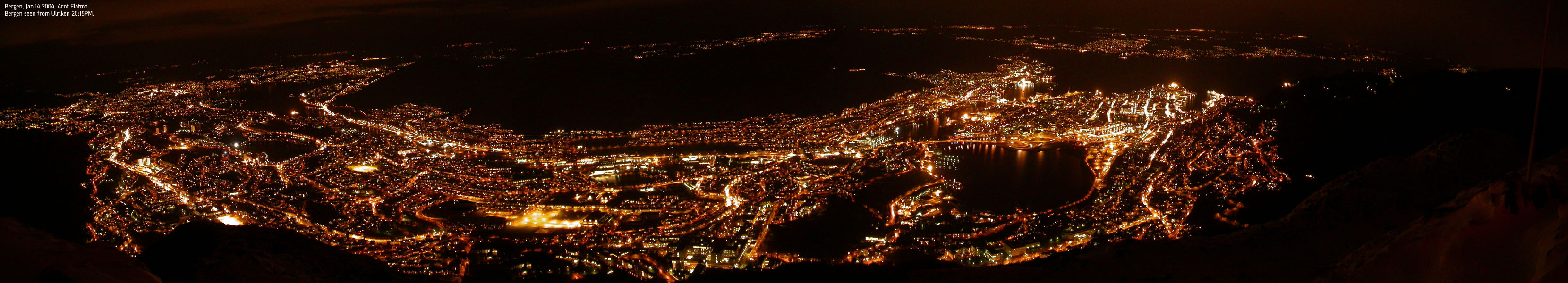
Ulriken tower (No Javascript) It's late one December evening in Bergen. As normal for this season, it has been raining heavily. For days. But right now, there is a break between the rainshowers. You look up towards Mt. Ulriken and see that the television tower is hidden behind the fog. But a shimmer from the top tells you that the fog layer is thin and the colors from the tower spotlights are just waiting to shine through. The mountain looks inviting, and you decide to pay the summit a late evening visit. You follow the Langrinden ridge trail and gradually rise above the city. It's an impressive thing, to have a whole city below your feet. It's late in the evening, but you really don't need the headlamp; the fog reflects the city lights from below, and the tower spotlights are radiating from above. Besides, you know this trail inside out, you've been up here hundreds of times. The sounds from the city begin to fade. You hear a siren, but this sound eventually drowns in the noise from a stream below you. You wonder if you've ever seen this stream any bigger than it is tonight.

Panorama from the tower (No Javascript) Your mind wanders about on details in the terrain. You reflect on the trail erosion. A pond has built up and isn't draining. You stop for a brief moment to lead the water away from the trail. You feel you've done something good. Something useful. It wasn't all that much, but at least you can keep an extra eye on this pond next time you go up the mountain. You start moving into the fog. Thousands of lights are slowly fading, through a veil of haze. It's a beautiful scene. You've brought your digital camera, and you take a few pictures. However, you realize that you will be disappointed when you see the pictures. This moment is multi-dimensional and cannot be captured through x times y pixels. As you're wrapped in the fog, the only sound you hear is from the winds up by the tower. You try to find words describing the sound. It is difficult, as you've never heard this kind of deep roar anywhere else. Captured by the moment, you turn slightly pompous and imagine that if there was a God who was angry, these would be the sounds of an angry God. The winds are picking up, and you wonder how strong they will be on top. The shimmer from above is getting stronger, and suddenly, the tower vaguely presents itself, and only for a brief moment. The tower dominates you completely, at least seen from your angle. In the next second, you only see the concert of colors as the spotlights change, and the steaming fog pass in waves, at incredible speeds.

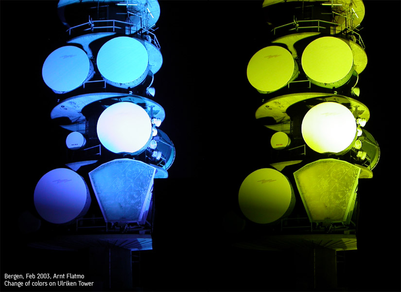
The change of colors (No Javascript) In many ways, it's a breathtaking moment. A work of art that never can be claimed or captured. You try to find words to describe this scene to friends, yet knowing the futility of it. The best you can hope for is a "sounds great!". You wonder if you'll run into a stray late evening walker on top. In one way, it would have been nice; someone to share the moment with. On the other hand, it would be no longer your moment alone. You know you're damned alone near the top of this mountain, while 250,000 people live at the mountain foothills. And you enjoy it to the fullest. You've reached the top now, and are standing below the tower. The winds are at their strongest here. You pull out your anemometer. The meter reads 17 meters per second. You try to stand still, but the wind doesn't quite let you. You're a bit disappointed, as you know how rough it can get up here. Your mind wanders back to the evening where you could lean backwards without falling. You hope to experience that sensation one more time, but it's not going to be this evening.

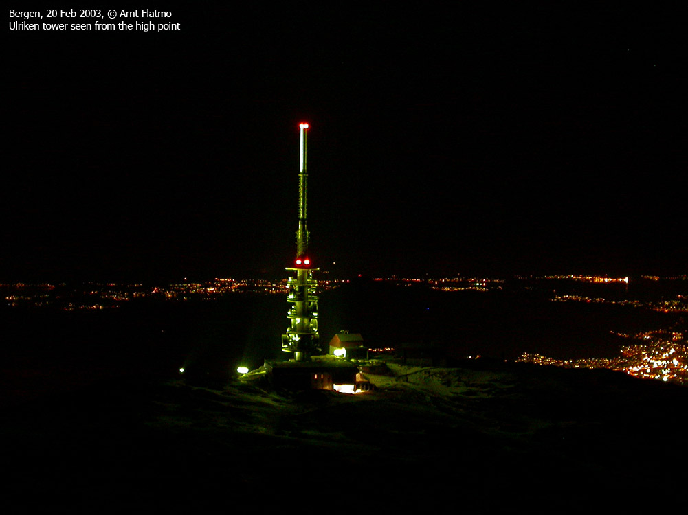
Ulriken tower seen from the high point (No Javascript) You're looking down on the spotlights, and you are completely overwhelmed by the rage and fury that the mixture of wind, colors and fog can produce. The fog is passing like an express train, shifting colors every other second. It feels like standing on top of a giant chimney, about to explode. You raise your hands and let the wind rush up under your jacket. You have a faint hope that the winds will lift you up, knowing this won't happen. You lower your hands and get back to reality. You're heading down the mountain. You're quite uplifted, and your mind wanders on good things. After a while, you're back in the zone where the semi-transparent veil of haze reveals the thousands of lights from the city. You're on your way back to civilization. What of it? You feel light and strong. Come what may. |

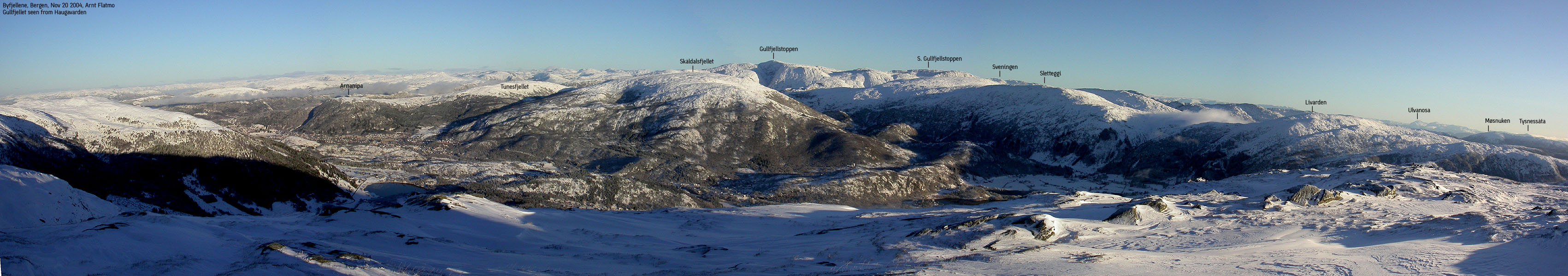
Gullfjellet seen from Haugavarden (No Javascript)
Haugavarden - which is the massif high point is indeed a very prominent mountain in Hordaland scale. Measured by primary factor, it ranks as #17 on the Hordaland list.
The mountain (M711: 673m, Ø.K: 674,5m ~ 674m) has a primary factor of 591m towards the higher Livarden (683m). The saddle near lake Søylevatnet on the east side. Lake Haukelandsvatnet drains north to Sørfjorden. This eliminates a vast part of the valley between the Ulriken and Gullfjellet massifs. Furthermore, lake Søylevatnet drains south, via lakes Nesttunvatnet and Nordåsvatnet, and eventually to the sea.
This leaves the area between lake Søylevatnet and lake Haukelandsvatnet. More precise, at the northern foothills of Rislikampen (the northern ridge of Totlandsfjellet) and west of the stream from Totlandsfjellet to lake Haukelandsvatnet. Ref. Økonomisk Karverk (5m contours), you cross the 85m contours in this saddle, but not 80m. The saddle height has been interpolated to 83m.
Ulriken (M711: 642m, Ø.K: No height. Highest contour is 640m) has a primary factor of 34m towards the higher Haugavarden (674m) The saddle is found SE of the summit and ref. Økonomisk Karverk (5m contours), you cross the 610m contours on the high route, but not 605m. The saddle height has been interpolated to 608m.
Storafjellet (M711: 662m, Ø.K: No height. Highest contour is 660m) has a primary factor of 24m towards the higher Haugavarden (674m) The saddle is found near the summit and ref. Økonomisk Karverk (5m contours), you cross the 640m contours on the high route, but not 635m. The saddle height has been interpolated to 638m.
Landåsfjellet (M711: 427m Ø.K: No height. Highest contour is 424m) has a primary factor of merely 44m towards the higher Haugavarden (674m) The saddle is found near Landåseggen and ref. Økonomisk Karverk (5m contours), you cross the 385m contours on the high route, but not 380m. The saddle height has been interpolated to 383m. This point is named "Nubbane" on Ø.K.

Ulriken seen from Landåsfjellet (No Javascript)
 |
Ulriken trails from Montana |
more to follow soon...
|
Ulriken by night |
|
Ulriken - misc. pictures |
Bergen seen on the way to Ulriken
|
The following pages are under construction.

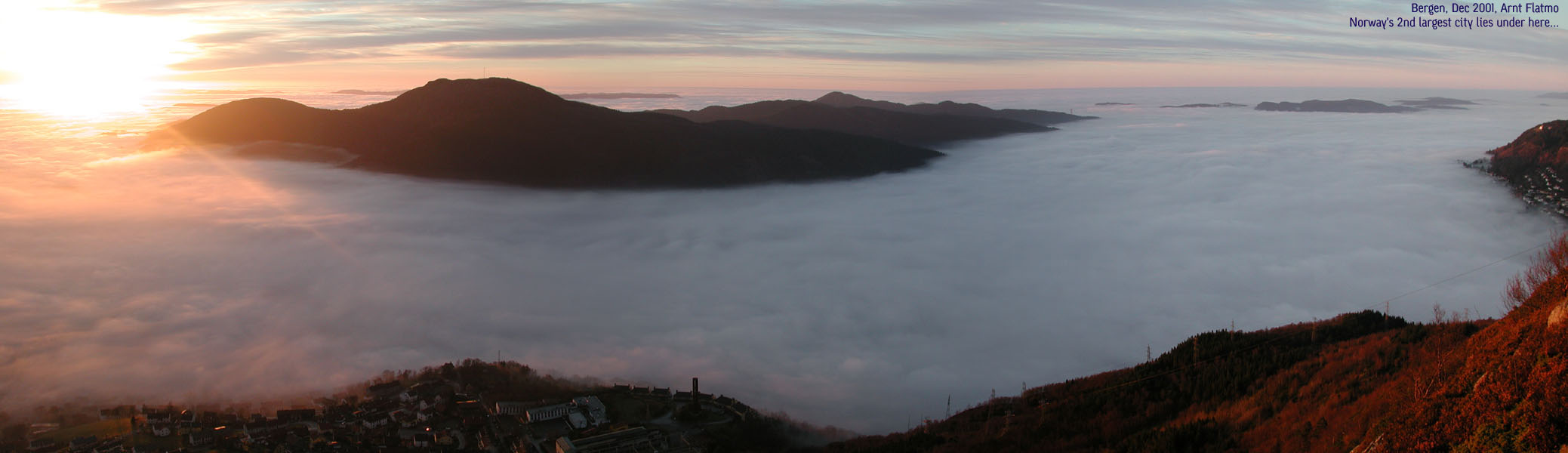
Not seen every day; Bergen hidden below the fog (No Javascript)
Photos:

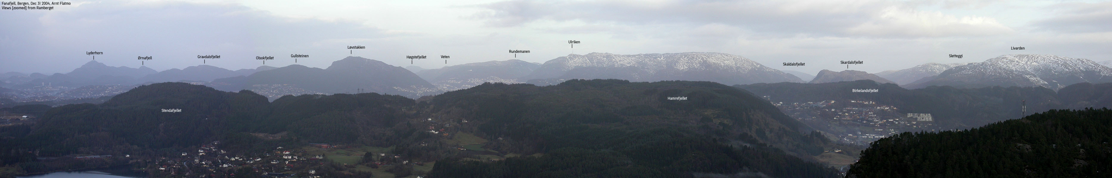
Bergen mountains seen from Fanafjell (No Javascript)
Other hordaland mountains
 Other Bergen K. mountains
westcoastpeaks.com
Other Bergen K. mountains
westcoastpeaks.com
