
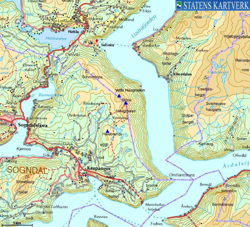
Norwegian Mountains, Sogn og FjordaneStore Haugmelen, 1172m
|
| Fylke/Kommune : | Sogn og Fjordane/Luster,Sogndal | ||||||||||||||||||||||||
| Maps : | 1417-III Sogndal (Statens Kartverk, Norge 1:50 000) | ||||||||||||||||||||||||
| Primary factor : |
Store Haugmelen: 974m Vetle Haugmelen, 108m Helebrandseggi: 90m |
||||||||||||||||||||||||
| Hiked : | Jan 2010 | ||||||||||||||||||||||||
| See also : |
| ||||||||||||||||||||||||
| See also : | Other Sogn og Fjordane mountains on westcoastpeaks.com |
 seen from the air")
Haugmelen (right) seen from the air
(Click for larger image)
Store Haugmelen is located 11km east of the town Sogndalsfjøra and has a shared border to the municipalities Sogndal and Luster. The mountain is also the highest point in a mountain region enclosed by Lake Hafslovatnet, Barsnesfjorden, Eidsfjorden, Sognefjorden and Lustrafjorden and offers fantastic views towards Sognefjorden (Norway's largest fjord) and some of its many fjord arms.
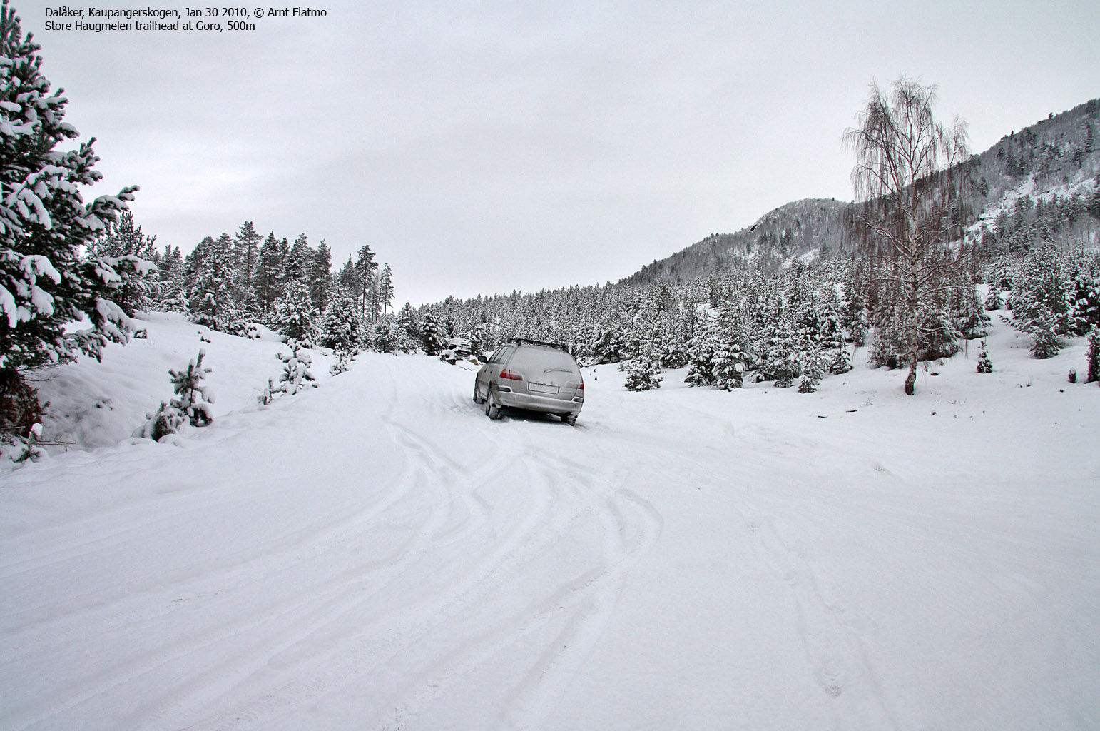
The mountain is popular in all seasons, one can ski this mountain without having to cross through avalanche terrain. One of the most popular starting points is Goro (500m) above Dalåker. A winter route from here is described on this page.
Vetle Haugmelen is located only 900 meters northwest of Store Haugmelen, and one might think that the intention is that the Sogndal/Luster county border runs across this top. If this is true, then the person who drew the map has a bad day at work. The summit is 118 meters away from the municipality (map) border, so the conclusion has to be that Vetle Haugmelen belongs to Luster only.

Haugmelen seen from Molden
(Click for larger image)
Helebrandseggi is found 3,7km southwest of Store Haugmelen, and is a shorter ski-trip from Goro. Helebrandseggi belongs to Sogndal municipality.

Helebrandseggi seen from Haugmelen
(Click for larger image)
Store Haugmelen (Norge 1:50,000: 1172m, Økonomisk Kartverk: 1171,63m, UTM 32 V 408988 6791615) has a primary factor of 974m towards the higher parent Krokberg (1356m). The defining saddle (approx. UTM 32 V 404293 6797868) is found in a road junction near Galden, east of Lake Hafslovatnet. Ref. Økonomisk Kartverk (5m contours), the saddle is within the range 195-200m, interpolated to 198m.
Vetle Haugmelen (Norge 1:50,000: 1118m, Økonomisk Kartverk: -, UTM 32 V 408360 6792265) has a primary factor of 108m towards the higher parent Store Haugmelen. The defining saddle (approx. UTM 32 V 408845 6792052) is found between these two tops. Ref. Norge 1:50,000 (20m contours), the saddle is within the range 1000-1020m, interpolated to 1010m.
Helebrandseggi (Norge 1:50,000: 920m, Økonomisk Kartverk: 920,35m, UTM 32 V 407130 6788115) has a primary factor of 90m towards the higher parent Haugmelen (1172m). The defining saddle (approx. UTM 32 V 408408 6788546) is found south of Storavatnet. Ref. Norge 1:50,000 (20m contours), the saddle is within the range 820-840m, interpolated to 830m.
 seen from the air")
Haugmelen (right) seen from the air
(Click for larger image)
Google's interactive map. You can zoom, pan and click on the markers.
|
|
|
|
Route 1: Dalåker/Goro - Store Haugmelen (winter)
|
|
This route description is valid per Jan 2010
Access
(all distances are approx. distances)
The nearest bigger town is Sogndal (has an airport). From Sogndal, follow highway RV5 southeast in the direction of Kaupanger. At Kaupangerskogen, turn right towards Kaupanger/Sogndal Lufthavn (signposted). Continue to the first roundabout and turn left (Kaupanger industrial area [symbol]). After 100m, turn right towards Dalåker (signposted).
1,6km up the road to Dalåker, stay right (straight ahead) in a fork. After 700m, the road turns sharp to the right. 800m later, you pass a gate (N61.20097 E7.24658). The road is closed here in summer. After 250m the road turns sharp left. Drive north 1,7km to Goro and the public winter parking (provided the road has been ploughed).
The route
From the parking (N61.21325 E7.24768), follow the forest road 1,8km to the north. The forest road forks (N61.22838 E7.25466). Turn right towards Vassløysa (the road to the left runs towards Breidesete) which you reach 1,8km later (there is one downhill on the way to Vassløysa).
From Vassløysa (N61.23912 E7.27645), continue northeast 200m until you reach a small valley which takes you to the foot of the mountain. Pick your ascent route. Depending on your route selection, you may pass by point 1169m, which means you get a short downhill before you ascend up to the summit - marked by a proper cairn.
Descend your ascent route or head west towards Breidesete and the forest road that in turn connects to your ascent route.

Vassløysa cabins
(Click for larger image)
|
Route 2: Dalåker/Goro - Vetle Haugmelen (summer)
|
|
This route description is valid per Sep 2011
Access
Same as for Store Haugmelen (above). Note tha the road to Goro is closed by a gate (N61.20097 E7.24658) near Dalåker. A bike could come in handy...
The route
From the parking (N61.21325 E7.24768), follow the forest road 1,8km to the north. The forest road forks (N61.22838 E7.25466) close to Syresete. If you're on bike, consider leaving it here. Turn right towards Vassløysa (the road to the left runs towards Breidesete) which you reach 1,8km later (there is one downhill on the way to Vassløysa).
From Vassløysa, continue northeast off-trail approx. 2km up to the top of Vetle Haugmelen. Alternatively, follow the path in the direction of Store Haugmelen until it's time to turn towards Vetle Haugmelen.
Upon descent, consider descending (off-trail) to Breidesete and follow the forest road along Breidesetevatnet back to the fork near Syresete. This will give you a nice round trip hike in easy terrain.

Breidesetevatnet
(Click for larger image)
|
Route 3: Dalåker/Goro - Helebrandseggi (winter)
|
|
This route description is valid per Mar 2011
Access
Same as for Store Haugmelen - above.
The route
From the parking (N61.21325 E7.24768), follow the forest road 1,8km to the north. The forest road forks (N61.22838 E7.25466). Turn right towards Vassløysa and Store Haugmelen. Approx. 400 meters later, leave the route and head (off-trail) up the birch forest. Once out of the forest, you still have 1,3km of skiing ahead of you. The summit (N61.21636 E7.27101) is marked by a few rocks.

Haugmelen seen on the way to Helebrandseggi
(Click for larger image)
|
|


