
|

Skagastølstindane(No Javascript) |

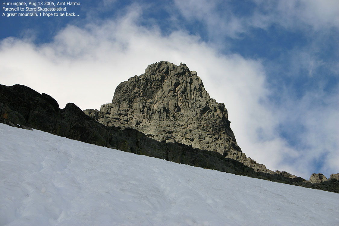
Store Skagastølstind is the 3rd highest mountain in Norway, located in the Hurrungane mountain region on Sognefjellet. The mountain is the highest among "Skagastølstindane", and the traverse across these peaks is known as "Skagastølsryggen". The mountain was first ascended by the British mountaineer William Cecil Slingsby in 1876. A legendary achievement in the early days of Norwegian mountaineering.
The summit is located on the Luster/Årdal kommune border, Sogn og Fjordane county. The height 2403m has for a long time been the official height of the mountain, but the official height is now 2405m.
There are numerous routes to Store Skagastølstind, and all involve various level of climbing in very exposed terrain. "Storen" - (the big one) which is the popular name of the mountain, is mostly climbed in the August timeframe, just before the new snow falls. The most popular routes offer easy climbing when the rock is dry. With rain, ice and snow, everything gets more challenging. Some climbers will climb this mountain unroped. In addition to the steep faces and exposure, rockfall is a major problem. The rockfall is both caused by the climbers and for natural reasons. Fatal accidents have occured on this mountain because of rockfall.
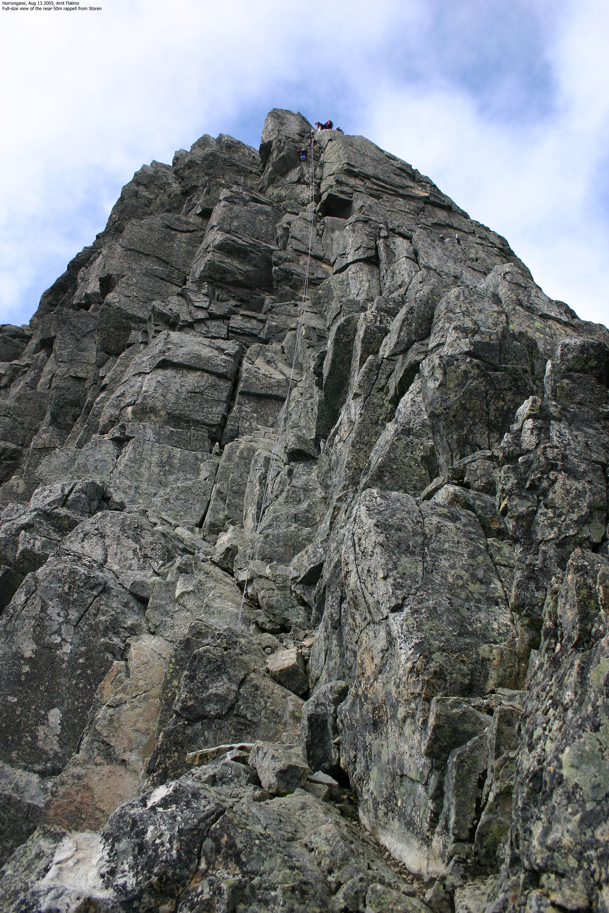
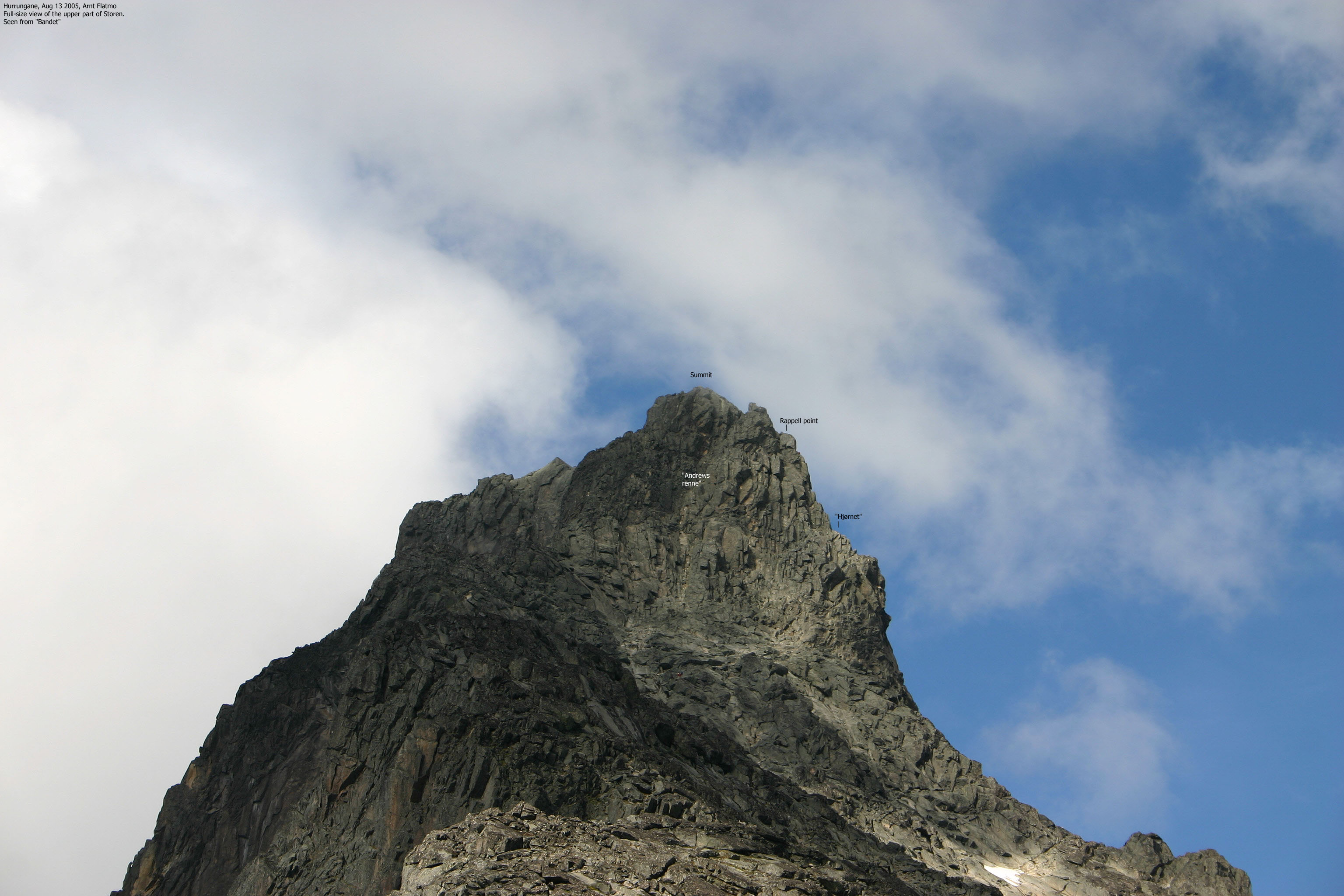
Skagastølsryggen and Styggedalsryggen are two of Norway's finest ridge traverse routes that both lead to Storen. These routes are long, exposed and require climbing in parts of the routes. But the most used route runs from "Bandet" - the pass that divides Skagadalen and Midtmaradalen valleys. From "Bandet", one proceeds to "Hjørnet" ("the corner") where you have several options. "Andrews' Renne" is a popular couloir, but offers the longest pitch of climbing. From "Hjørnet", several routes can be followed. "Heftyes renne" is the most popular of these routes, although it has the most difficult "crux" of all routes; 4+ in the Norwegian climbing scale. The normal descent from the summit is a 40-45m long rappel that ends close to "Hjørnet". A "feature" that is not easily forgotten.
When William C. Slingsby, Emmanuel Mohn and their guide Knut Lykken headed for the top one July day in 1876, they passed below the south face of Storen, headed up a glacier that is nowadays called "Slingsbybreen" (the Slingsby glacier) and entered a col between Vesle and Store Skagastølstind. Only Slingsby continued from this col which today is known as "Mohn's skar".
The primary source for climbing in this area is "Klatrefører for Jotunheimen", written in Norwegian (ISBN 82-991002-1-6). A lot of information also exists on the net. Search keywords are "Store Skagastølstind", "Storen", "Skagastølsryggen", "Skagastølstraversen", "Turtagrø", "Jotunheimen", "Hurrungane", "Sognefjellsveien". Visit the websites etojm.com and bergatt.net, for good information about the Norwegian 2000m mountains.
For guiding to Storen, contact Turtagrø hotel or Norgesguidene. If you plan to climb this mountain, *strongly consider* teaming up with someone who knows the route and the mountain. Be aware of the rapidly shifting weather conditions. Travel light, but be prepared for weather changes and sudden drop of temperatures.

Store Skagastølstind (M711: 2403m, Ø.K: -, other source: 2405m) has a primary factor of 1015m towards the higher Galdhøpiggen (2469m).
The saddle location is derived from Petter Bjørstad's list of Top 100 Mountains in Norway ranked by primary factor:
Since this mountain is the 3rd highest in Norway, we need to examine a highest possible path from here to Galdhøpiggen, 2469m. This path runs north to Fannaråki, then across a saddle north in Vetle Utladalen to Smørstabbreen, further across near Leirvassbu to the Galdhøpiggen area. The first saddle is in Jervassdalen at about 1470m, then about 1510 across to Keisaren. Noth of Fannaråki, east of Prestesteinsvatnet (1356-1333), there is a saddle west of Steindalsnosi (1488m) at interpolated 1390m, the 1400 contour passes through. At the other side of this peak is another saddle that interpolates to 1390m, this one is likely to be a bit lower, just judging from the map. The next saddle across north in Vetle Utladalen stays barely above 1400m, just north of Utledalstjørn (1403m). The next low point is near Leirvassbu, Leirvatnet is 1401 meter, the interpolated high path circles south and east around the lake across an interpolated saddle of 1410 meter. Thus, the lowest point is definitely below 1400m, interpolated between the 1380 contour and the 1400 contour to 1390 meter.
Saddle location: UTM: (32 447162 +6822638) (Petter operates with 2403m as the height, giving a primary factor of 1013m)
On the summit, and over a 10-minute period, I watched the GPS steadily report 2414m - 9m above the official height. The day after Storen, I visited Store Soleibotntind (2083m), and the GPS reported 2091m - 8m above the official height. This was noteworthy, as the GPS normally agrees with the map heights. At least for the mountains in Hordaland, which I frequently visit. I expect that the reason for the deviation will present itself one day.
Also noteworthy was that the summit location (32 V 439880 6814680) was 29,8m south of the 2404m summit point on the Garmin map. Infact, my summit point was *outside* the 2400m contours on this map.
Other sources:
Wikipedia reports 32V 439870 6814690 as the summit point. This is 13,9m NW of my reported position, and also outside the 2400m contours on the Garmin map. Statkart reports 32V 439878 6814678 which is almost the same as my reported position. Statkart reports that this is trig. point D30T0047 (base of cairn).

Notes:
|
Turtagrø - "Storen" via "Andrews' renne" (autumn)
|
|
Locate Turtagrø hotel along Sognefjellsveien (RV55 Sogndal - Sel), 884m elevation. Parking is found other side of the road. You can only get to Turtagrø via car or bus. From Bergen, it is convenient to drive to Øvre Årdal (via Lærdalstunnelen) and continue up the toll road to Turtagrø, avoiding the ferry across Sognefjorden. From Oslo, you have several options: via Otta (E6), via Fagernes (RV51) or Fillefjell-Tyin-Øvre Årdal (RV53)
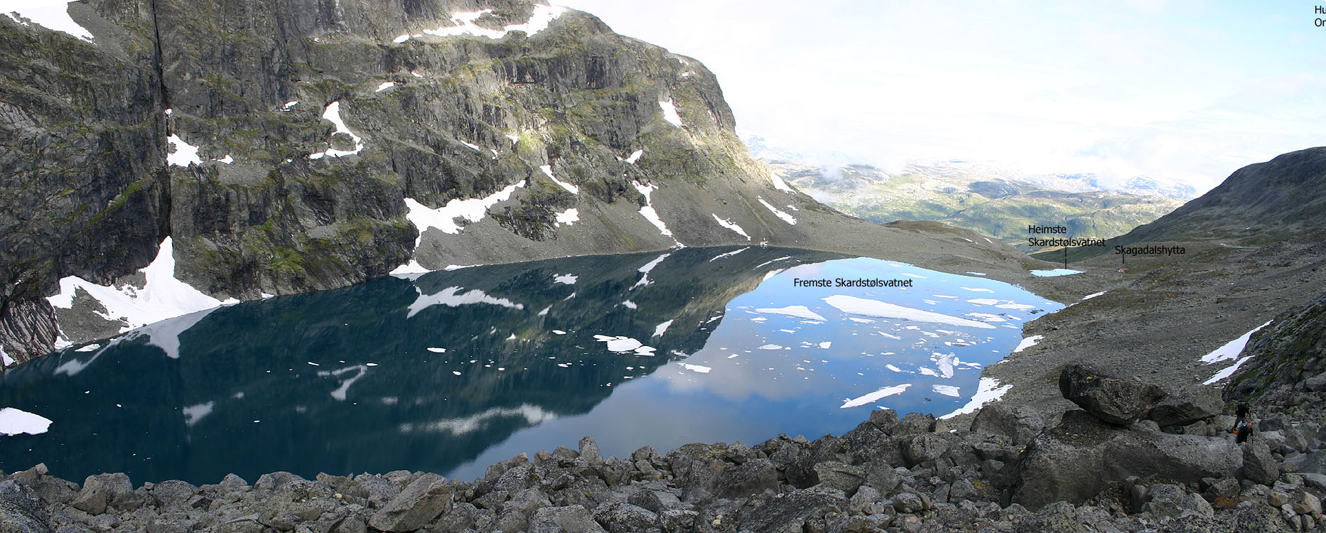
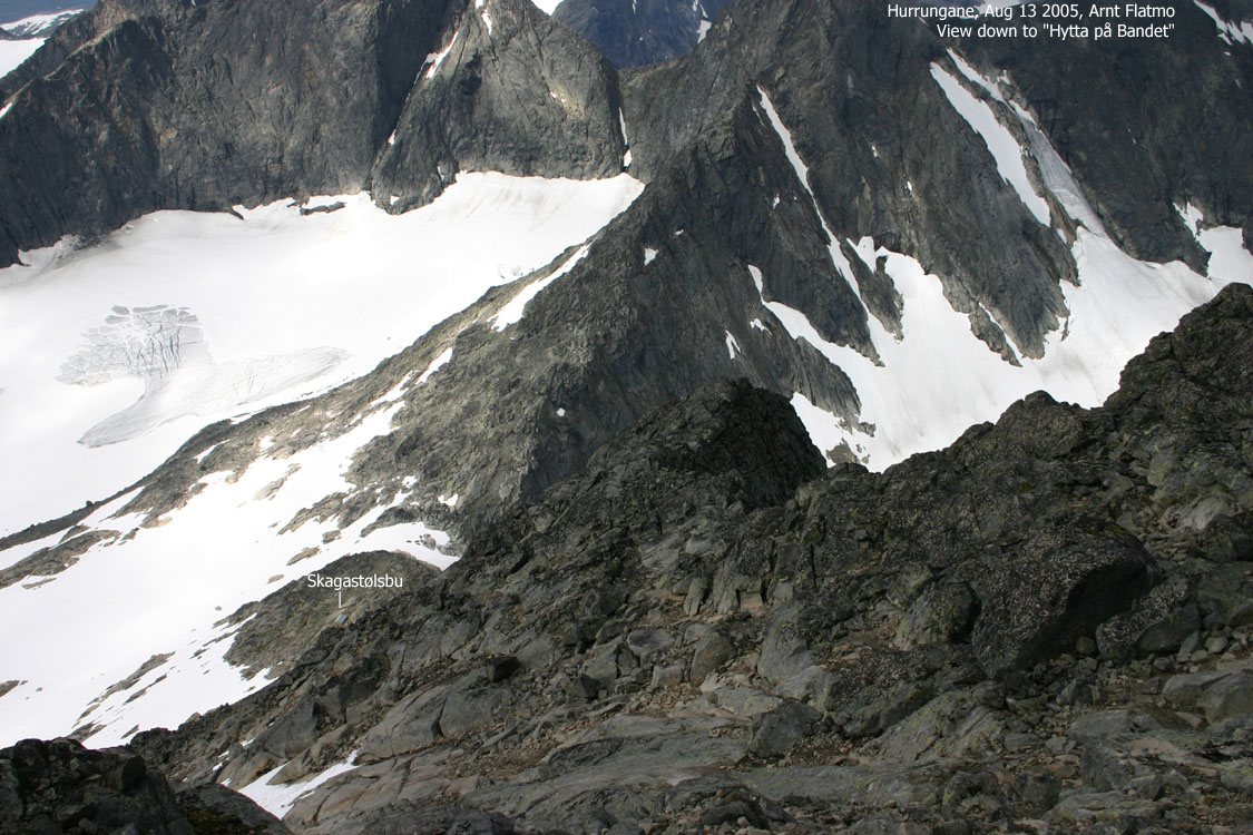
Follow marked trail into Skagadalen. The route climbs up to Heimste Skardstølsvatnet where Skagadalshytten (1344m) is located. This hut is owned by Norsk Tindeklubb and is reserved to its members and their guests. Because of avalanche danger, the winter route runs up Dyrhaugsryggen and along the 1400m contour towards the lake. Proceed along Lake Fremste Skardstølsvatnet (1370m) and across Skagastølsbreen up to Skagastølsbu ("Hytta på Bandet") at 1758m.
Many prefer to spend the night inside the hut, or camp outside. The hut is a self-served DNT hut with 4 beds. Expect a full hut (people on the floor) in the busy season.
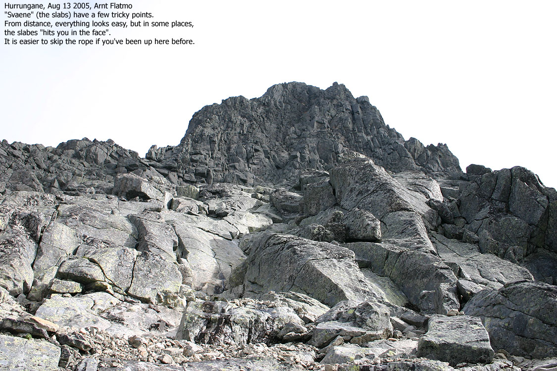
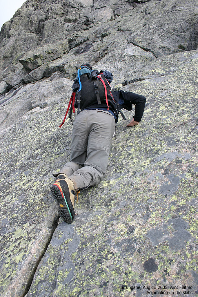
Proceed up the snowfields which may require ice-axe and crampons. The further route is not officially marked, although you may see a small cairn here and there. Above the snowfields, you enter a distinct slab area. Routefinding is essential here. On dry rock, some may choose to pass the best route unroped. Avoid drifting towards the right. The left-hand side of the slab area offer the best route.
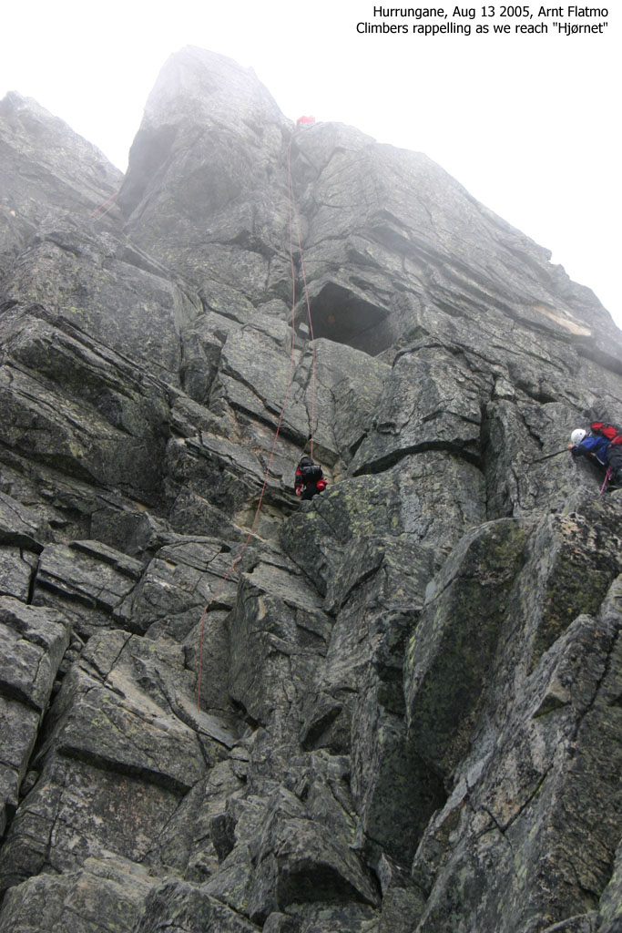
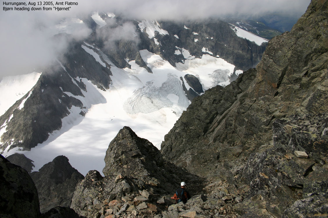
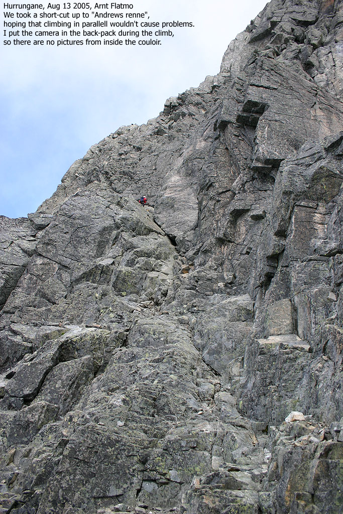
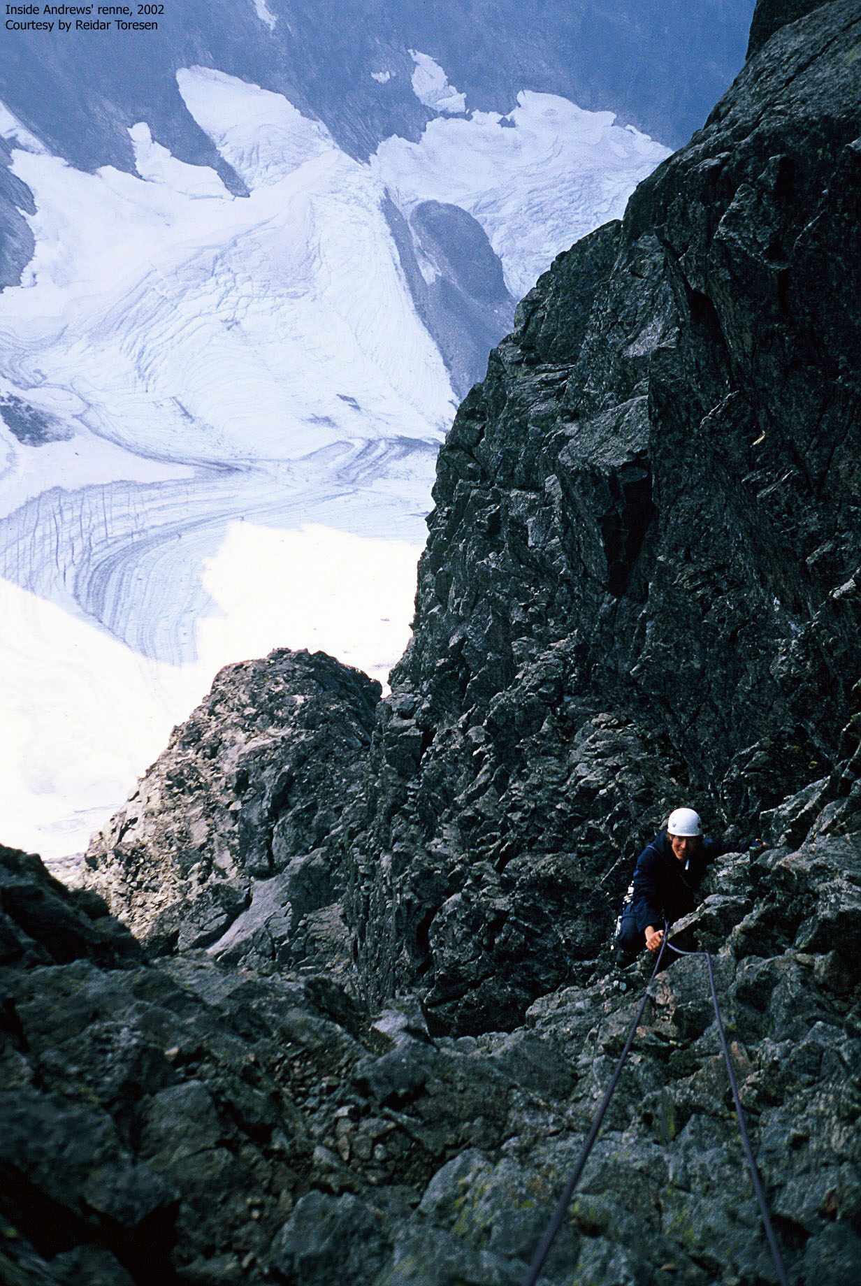
The terrain from the slab area up to "Andrews' renne" is easy, providing you locate the correct route. Unless the mountain is completely fogged in, it is easy to identify "Andrews' renne". This couloir begins a slightly below "Hjørnet" and runs northeast from the center of Storen's southwest face, up to the pass that separates the summit from the front top. From the base of the couloir, you may consider to continue towards "Hjørnet", and take a short-cut (easy scrambling) into the couloir.
"Andrews' renne" is rated class 3+ in the Norwegian climbing scale. The climb is 3 rope lengths (approx. 120m total) The couloir gets gradually steeper and exposed, but the climbing is moderately difficult. Climbing shoes are recommended if you don't expect to freeze. Inside the couloir, you have several options for holds, but be aware of loose rock. Do not cause rockfall! There are most likely other climbers below.
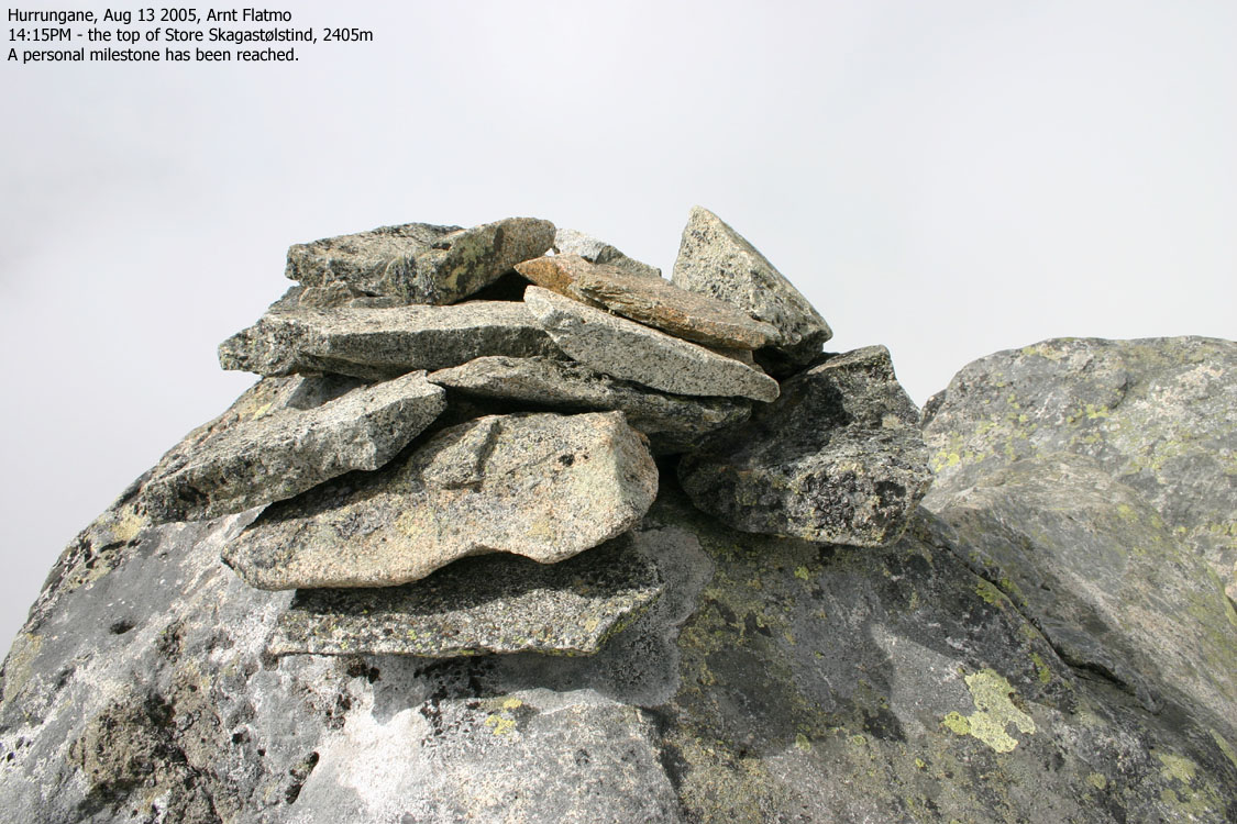
At the top of the couloir, turn left and scramble the short section up to the summit. The first step can be a bit tricky, especially during descent. Most climbers continue roped all the way to the top, although the top section is easy scrambling. The summit is marked by a few rocks, which you should avoid touching.
Descent
Head back down to the pass and enter the front top. Descend to the left through a narrow pass between the mountain and a rock. Then turn right before you get to a long ledge and you will locate the rappel point. A fixed, solid runner is located here (it is replaced once a year). Rappell straight down the face, as far as you can or until you see that you can get back to the "path" to "Hjørnet". The rappel is 40-45m. Two 50m ropes are required here. With only one rope, your alternatives are a single-rope rappel or a double-rope rappel down "Heftyes renne" (not described on this page). Descend down to the start of "Andrews' renne" and descend your ascent route from here. Consider rappelling down the slab area.

Background
To me, Store Skagastølstind was always the "mother of all Norwegian mountains". But because of my fear of heights, I never dreamed about standing on top of this mountain. Not until I actively began to work on my vertigo two years ago. I scanned the net for trip reports and pictures and noticed that I was sweating when I looked at the pictures. But at least, the dream was born.
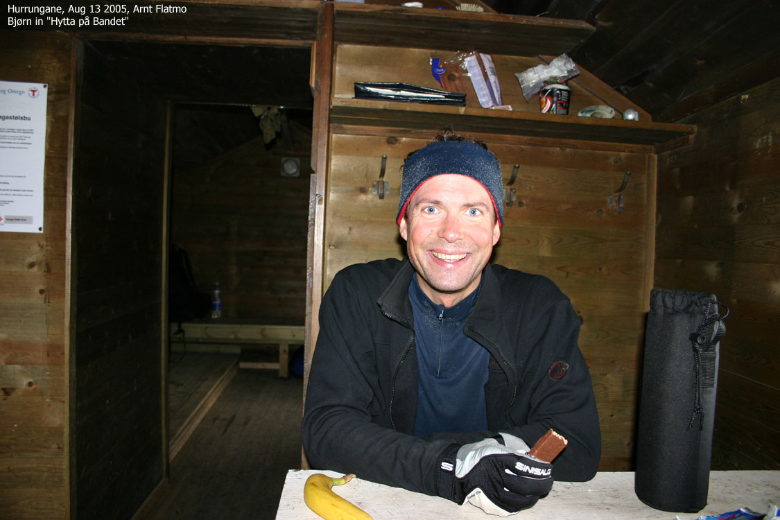
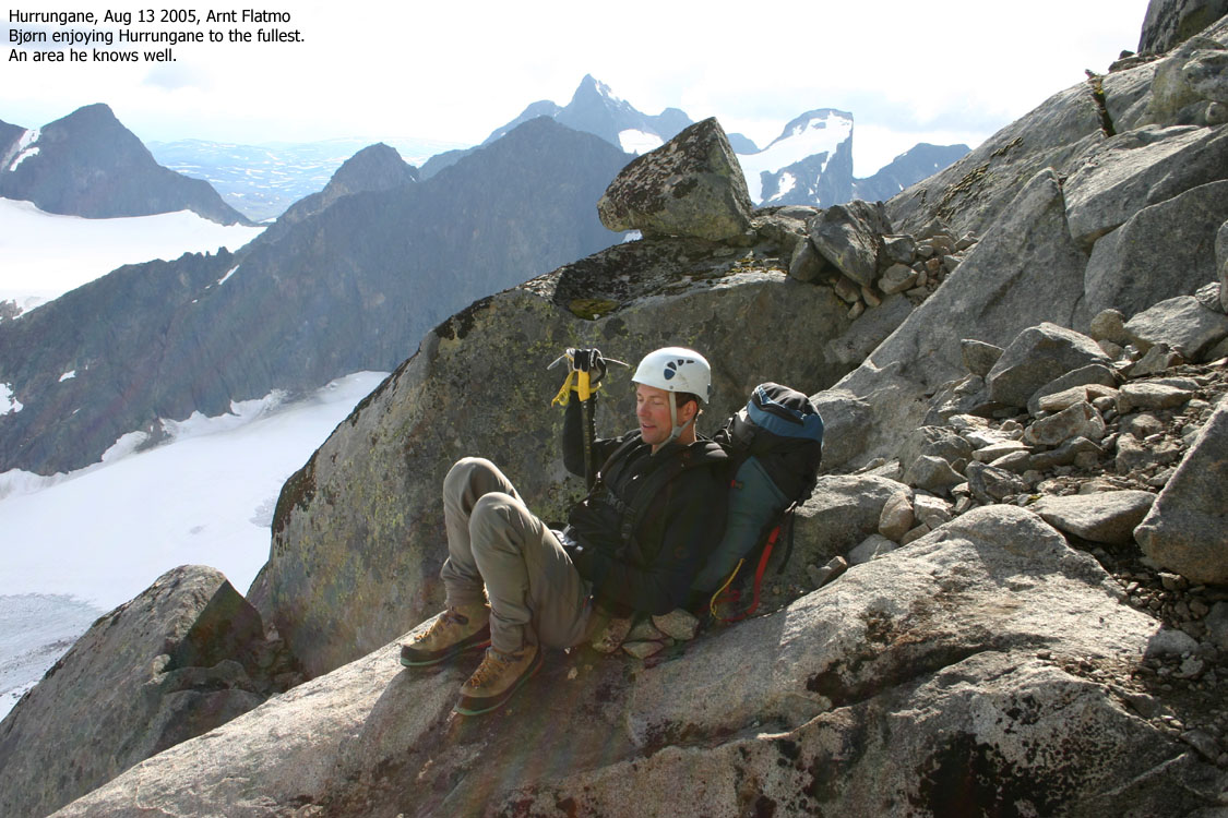
After our Greenland trip in 2004, I decided that "Storen" should be my goal for 2005. I needed a guide and was prepared to join in a guided group from Turtagrø. But then I remembered that Bjørn Eirik Hanssen, whom I met on the two-day ski-trip across Meneseggi in 2004 was a skilled climber and knew Hurrungane, and Storen in particular, very well. He has been to Storen at least 15 times and performed numerous climbs in Hurrungane, in all seasons. I asked him if he would be willing to come along on a trip. He gave a positive response, and only the weather would be the final factor. The original plan was that there would be three of us, but it ended up being only Bjørn and myself.
To Skagadalshytta
After checking the weather forecast on Aug 11, the trip was on. The forecast was a bit unclear, but it didn't look directly bad. But with Hurrungane, you never know for sure. Bjørn drove from Oslo on Friday afternoon. I drove from Bergen and we met at Turtagrø just before 22:00AM. As Bjørn is a member of NTK, we walked up to "Tindeklubbhytta" (Skagadalshytta) and "checked in" 23:20PM. We shared a 4-bed room with another couple. Bjørn had brought a pizza up to the hut, and after a delicious evening meal, we went to be 00:30AM.
I couldn't sleep at all. With the large roar from the river, I expected that the stable sound would put me to sleep, but it didn't. I thought of the project next day, but I didn't think of the climb or the exposure. That didn't bother me at all. I found that odd. I expected to be all wired up and tense, but I wasn't. But I thought about the weather, what to carry, what to eat, when to drink, and so on. The practical things kept my mind wandering half the night. As I might have been drifting into sleep, I was suddenly awake when a party came into the hut in the middle of the night. It was no more sleep the rest of the night.

To Storen
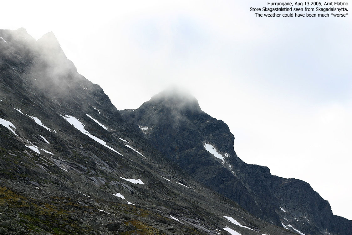
We got up 07:00AM and were on our way 08:10AM after breakfast. The weather didn't look bad at all. There was some fog on the summit, but the day had all the signs of a good day. We knew that numerous climbers were on their way, ahead of us. We hoped that we wouldn't be stuck at "Hjørnet", where precious time gets lost while standing in line. We kept a slow, but steady pace up to "Bandet" where we had a short break. We then proceeded up the snowfields and left our ice-axes at the end of the upper snowfield. We had left the crampons back at the hut as we had been told that the snow was soft. In the slab area, we came upon a section that made us put the harness on and rope up. This was easy, but exposed scrambling. I would have been OK with climbing unroped, but Bjørn probably figured that we should get into a climbing state of mind. The sooner the better.
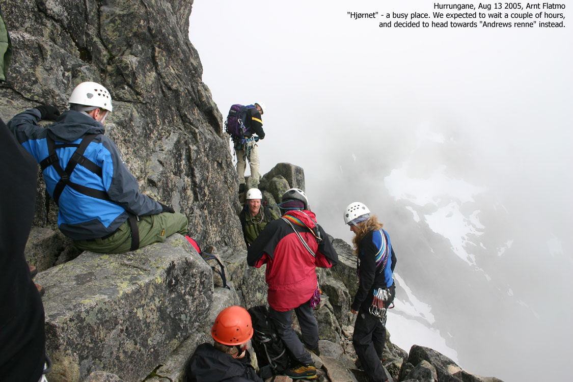
We continued up to "Hjørnet", which was packed. Bjørn estimated a two-hour wait and tried to "negotiate" parallel climbing with the other groups. The result was negative and Bjørn suggested that we should climb "Andrews' renne" instead. I was fine with the decision, and we headed back down the short pitch to this couloir. A large party was busy in the couloir and it would take hours to wait for them to complete. Bjørn laid out a plan for parallel climbing that would quickly get us ahead of them. It would be a "speed-climb" and I put the camera in the back-pack. We changed into climbing shoes and stripped the back-packs for everything we didn't absolutely need.
The start of the route was easy scrambling, but suddenly everything got very steep and exposed. The climbing was swift. Bjørn led quickly and I followed on as fast as I could. The other group were nice guys and didn't send us any negative messages about "crashing in". We didn't cause any problems for them, and they didn't cause any for us. While belaying Bjørn, I had all the time in the world to reflect on my whereabouts. In the middle of Storen's south face. I had been in steep terrain before and felt the adrenaline and fear take control over the body and mind. But not now. I felt safe and calm. A sensational feeling. I didn't know what was above me, but if it didn't get substantially more difficult, I knew that I could climb it.
At the third rope length, I passed 4 guys from the other group, taking a pause. I felt a bit clumsy in this section, which was the most difficult part of the route. I mumbled "Don't laugh. It's my first climb". Three of them replied "Mine too!" and I felt good again. Bjørn and I climbed up the top of the couloir and then up to the summit. The time was 14:20PM and it had taken us approx. 6 hours from Skagadalshytta. Adding approx. 1,5 hours between Turtagrø and Skagadalshytta the day before, the total time was approx. 7,5 hours. I didn't feel anything when I reached the summit. But I didn't expect to, either. All my previous "moments" needed time to mature. In time, I will fully appreciate this climb. No doubt about it.
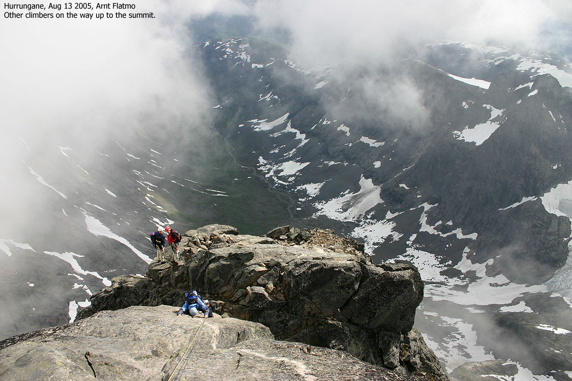
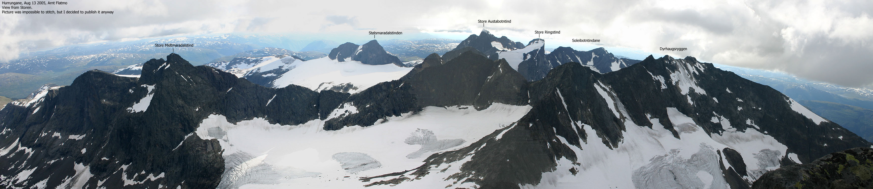
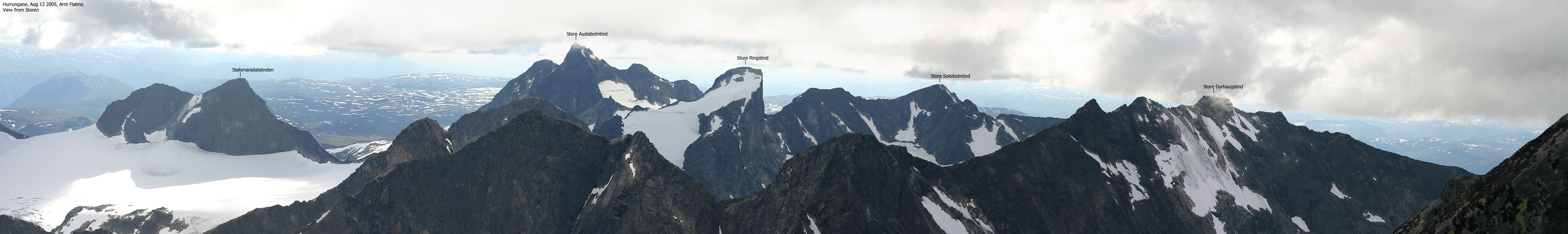
The summit hasn't a lot of space and one has to be careful when moving around. I tried to get some good pictures, but Skagastølsryggen and Styggedalsryggen were fogged in. But the views towards the west were good. I got busy with taking pictures and checking the GPS (see "Notes on height and location" above). Two other climbers - Konrad and Bjørn reached the summit a few minutes later. I had spoken with these guys down at Turtagrø Friday afternoon. They spent the night at "Bandet" and were in the process of climbing from "Hjørnet" when Bjørn and I turned around and headed for "Andrews' renne". We had decided to leave one rope behind at the base of the couloir, and agreed with Konrad and Bjørn that we should team up and join ropes. They were in the same position as us, and we then could avoid a single-rope rappel or rappelling down "Heftyes renne".
Disaster nearly happened when a climber touched one of the rocks on the summit cairn. The rock fell straight into "Andrews' renne", where a large party was on their way up. The rock hit the mountain inches away from one of the climbers before it exploded into smaller fragments. Even climbers on Dyrhaugsryggen noticed this rockfall. This is a good example of how dangerous the mountain is. Loose rock all over a crowded mountain. One guide I spoke to expected there to be *at least* 50 climbers on top that day. For sure, it had been the busiest day of the season.

Descent
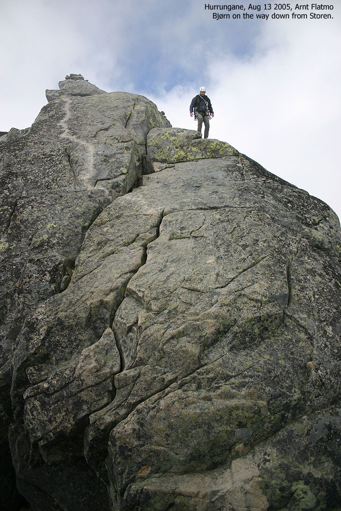
We left the summit 15:00PM and headed down to the rappel point which was busy. A group of three were climbing up here. They were already in the process when we turned around at "Hjørnet" and it seemed that they hadn't come much further. One person was still at the base of the pillar. I had some concern about rappelling in thick fog - not knowing when to stop - but having seen the rappel route from below put the worries at rest. I was the first one out and had to rappel past the last person in the other climbing group. I felt that this was a silly climbing route. The rappel point would be busy enough with people going down. With people coming up at the same time, the place gets very crowded.
I never had any concerns about the rappel itself, but I wasn't custom to using the French prusik. I hoped that it was mounted properly and without realizing it, my left hand kept working the rope. Bjørn shouted to me from above, telling me to let go. Once down, I waited for the others to come down before we proceeded down to our boots and other gear at the base of "Andrews' renne".
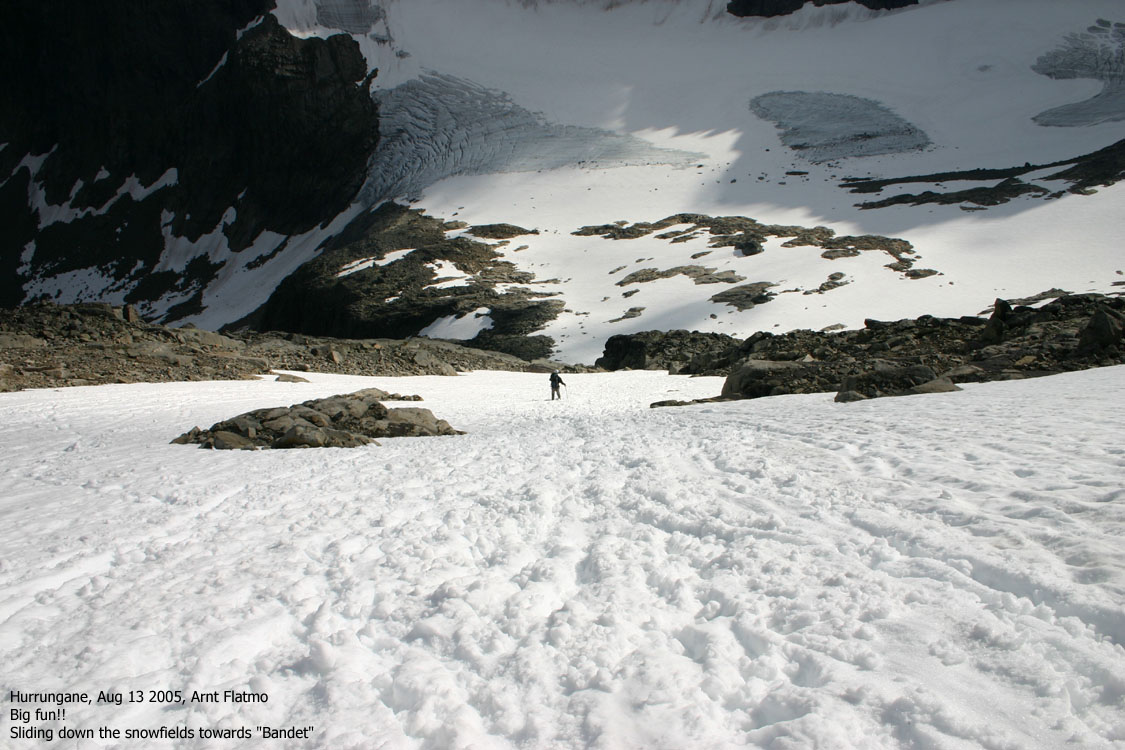
We caught up with Konrad and Bjørn at the slabs, and they were kind enough to let us rappel on their rope. We slided down the snowfields (great fun!) and had a break by "Hytta på Bandet" before returning to Skagadalshytta. We were back at the hut 19:15PM. We enjoyed a nice dinner (made by Bjørn, of course) and a bottle of red wine before we went to sleep. I had less problems sleeping that night, although my brain was busy processing all the events of the day.
We left the hut 08:15AM the next morning and were back at Turtagrø 09:30AM. Bjørn began his journey to Oslo while I drove to Berdalsbandet and hiked Store Soleibotntind. From the top of Soleibotntind, Storen looked like the Devils's Tower (Wyoming) and it was difficult to fully comprehend that I had been on top the day before. I would like so send a warm thanks to Bjørn for his excellent lead, and for the good atmosphere he creates around himself. I already look forward to our next trip together.
Move cursor to read notes, and click on the images to see full version.
Some of the thumbnails may have been cropped to fit the format.
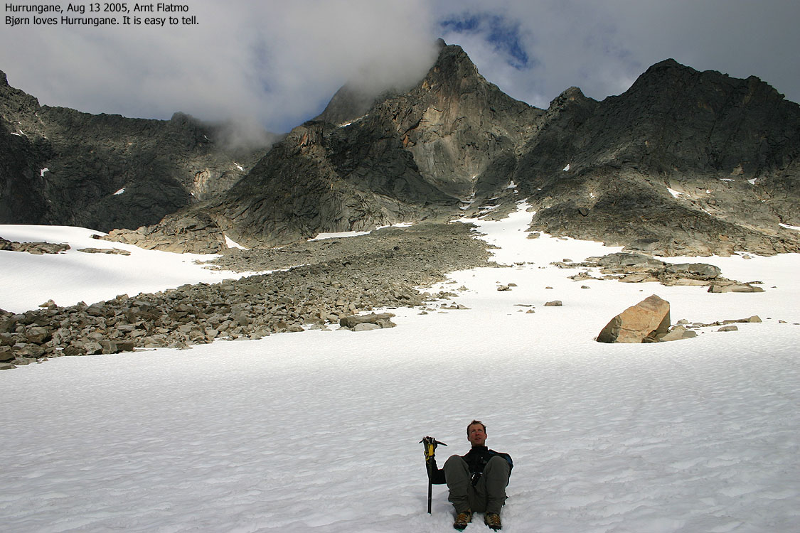
To Bandet, Aug 12-13


Up the snowfields, the slabs, "Hjørnet" and "Andrews' renne", Aug 13


There are no pictures from the climb itself, for various (and good) reasons, but you may see the Andrews' renne section below. Pictures submitted by courtesy of Reidar Toresen.
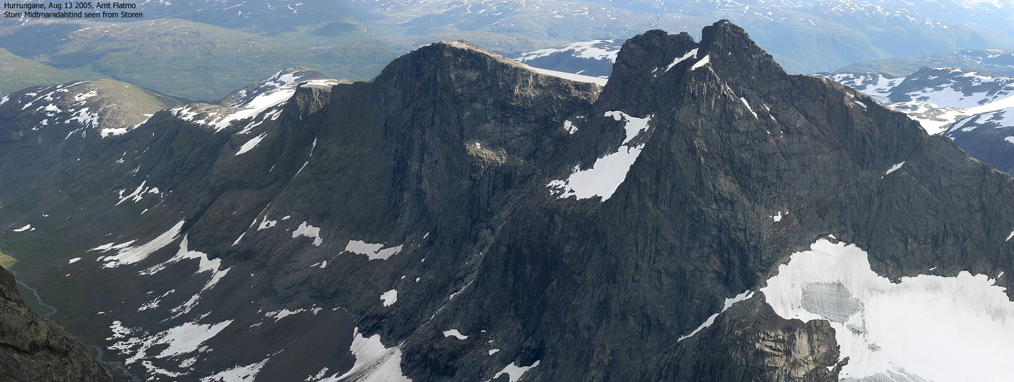
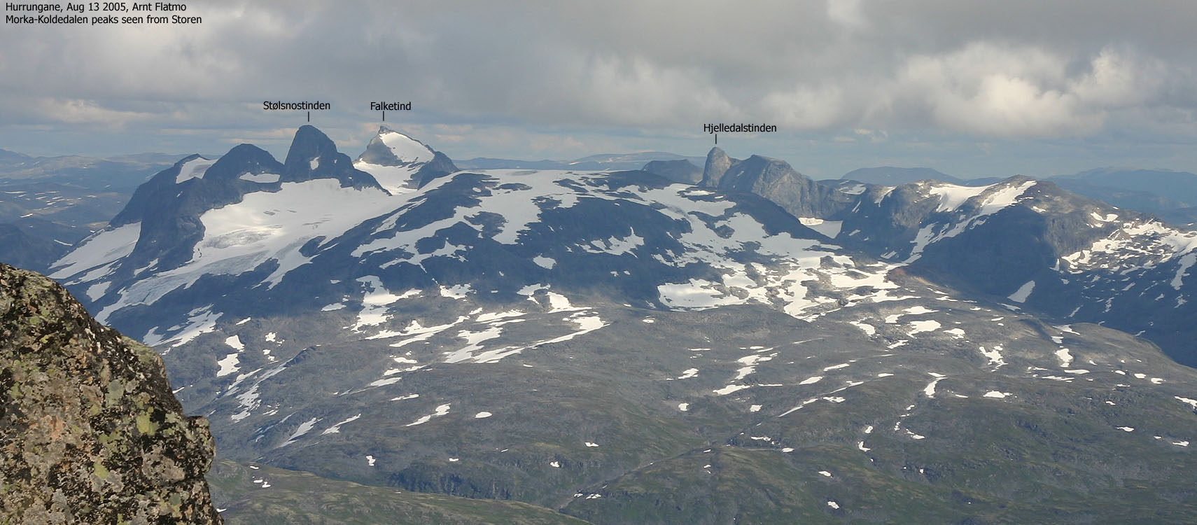
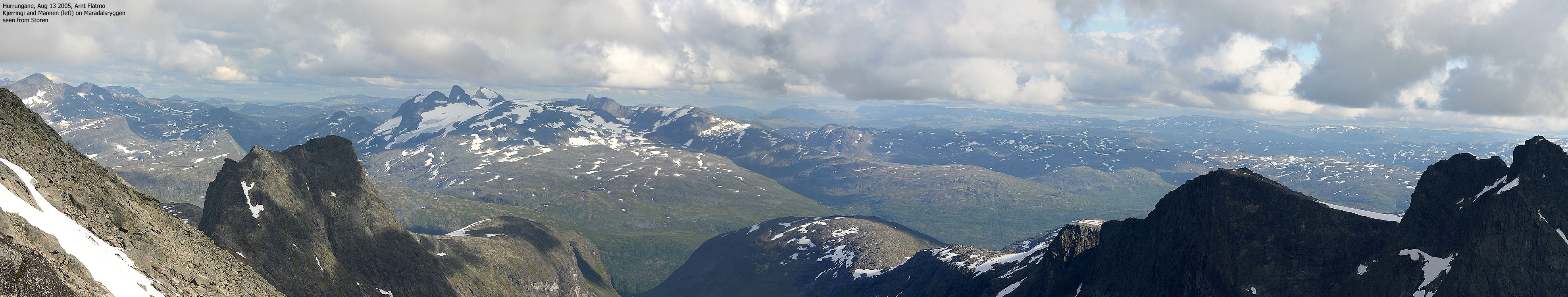
Summit and views


The rappel


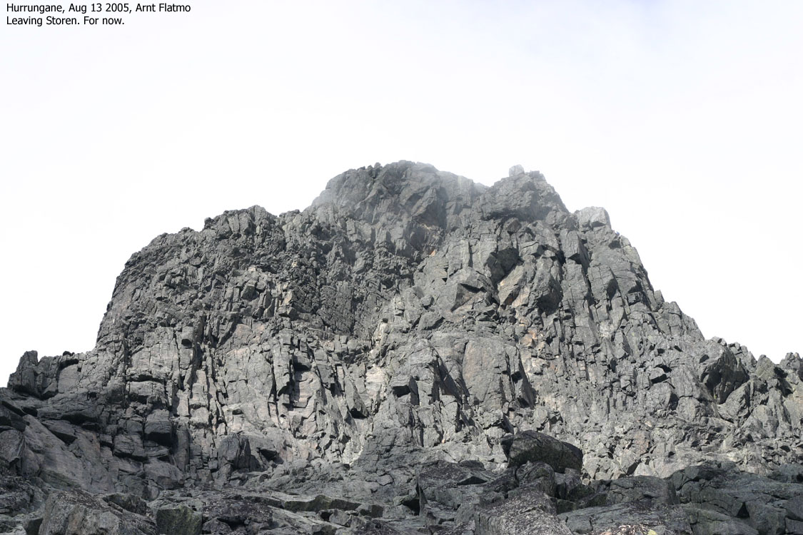
Descent and more views


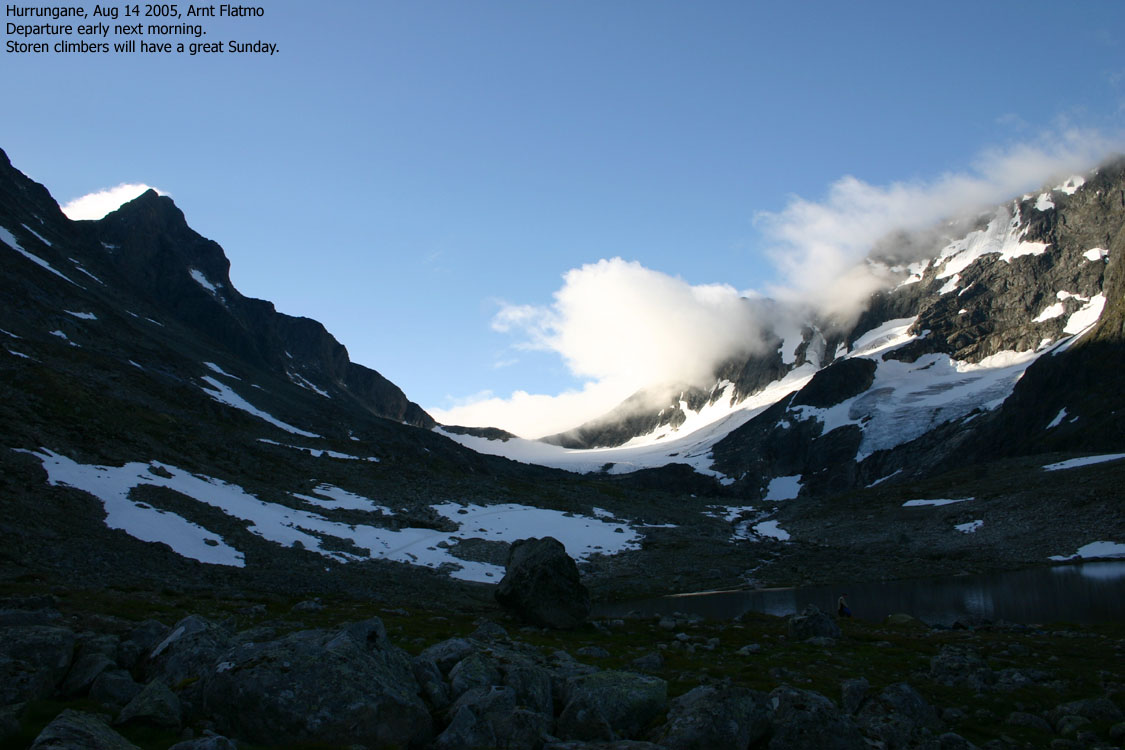
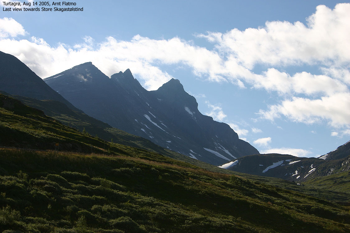
Next morning, Aug 14


No Javascript:
1 2 3 4 5 6 7 8 9 10 11 12 13 14 15 16 17 18 19 20 21 22 23 24 25 26 27 28 29 30 31 32 33 34 35 36 37 38 39 40 41 42 43 44 45 46 47 48 49 50 51 52 53 54 55 56 57 58 59 60 61 62 63 64 65 66 67
The pictures are taken in 2002 from a climb that Reidar performed together with Magne Olsen.


No Javascript:
Other hordaland mountains
 Other Norwegian mountains
westcoastpeaks.com
Other Norwegian mountains
westcoastpeaks.com

