
|

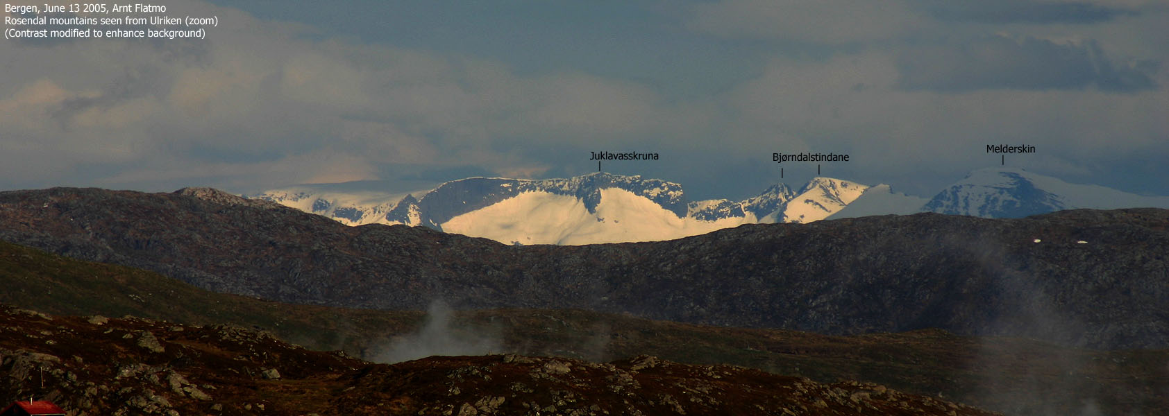
Juklavasskruna seen from Ulriken(No Javascript) |
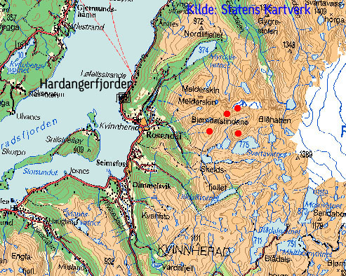
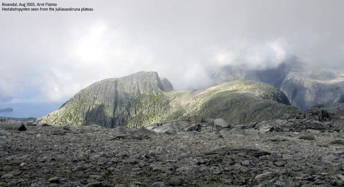
Bjørndalstindane and Juklavasskruna are located between Rosendal/Hardangerfjorden and the Folgefonna glacier. The peaks are in the heart of the mountain region also known as the "Rosendal alps". In terms of hiking/scrambling, this is the most demanding mountain region in Hordaland, as Bjørndalstindane and Laurdalstind demands class 3 scrambling on the easy routes. So far, I have not visited - or heard about other Hordaland mountains with class 3 on the easy routes. Although located further north, Gygrastolen also deserves to be mentioned along with the Rosendal alps, as entering the Gygrastolen summit is quite "airy" and somewhat tricky.
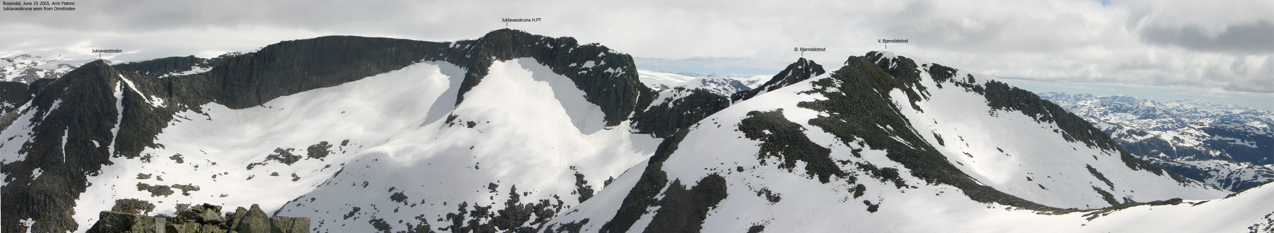
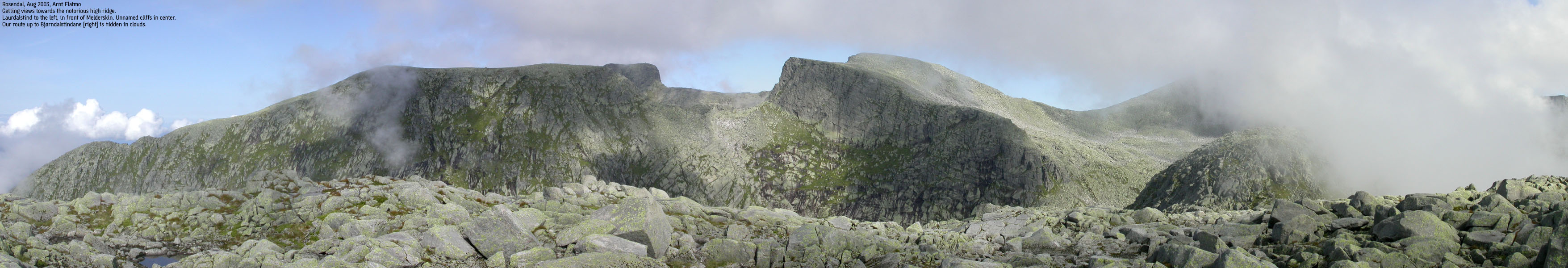
Before reading further; know that locally in Kvinnherad, point 1455m (described as Juklavasskruna high point on this page) is known as Inste (innermost) Bjørndalstind, and measures 1454m. Heimste (closest) Bjørndalstind is the same as Bjørndalstinden (1426m) as described on this page. The two minor Bjørndalstindane (east and west of 1426m) do not seem to have a local name. The locals refer to all of these tops as Bjørndalstindane, while Juklavasskruna is merely the large plateau further east.
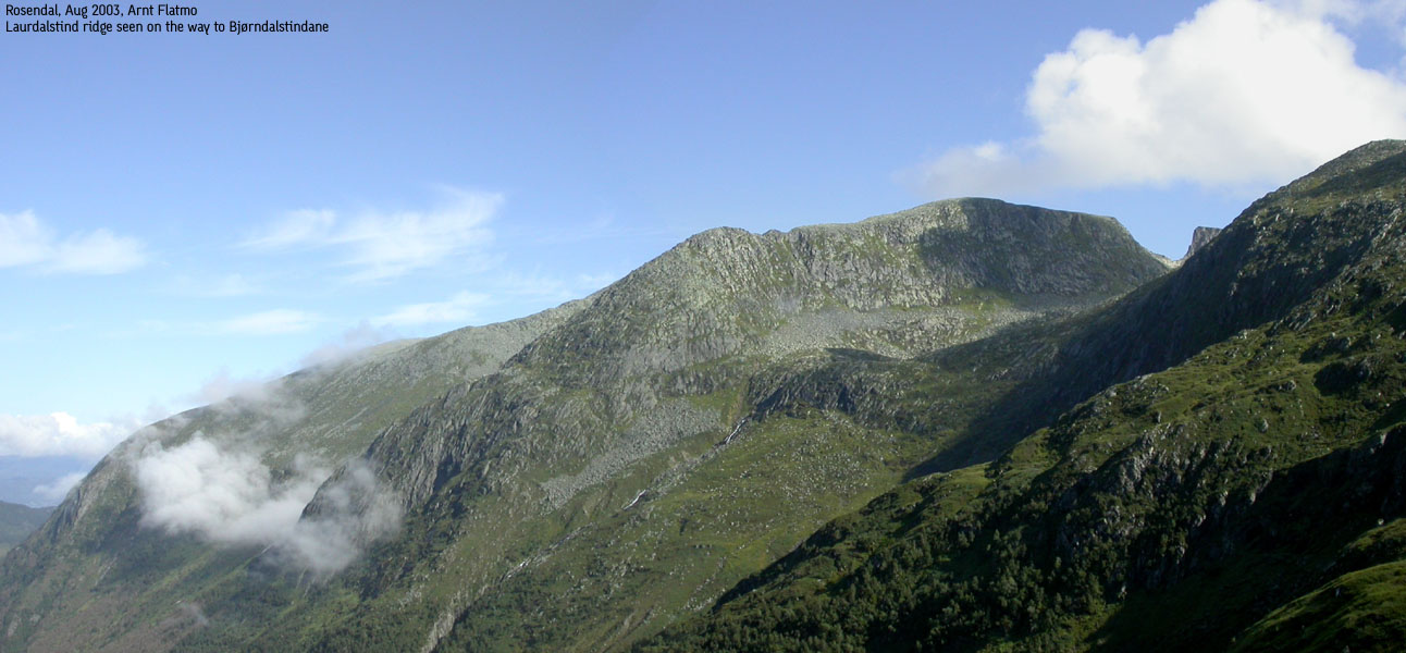
Summary; On this page, "Juklavasskruna" refers to the highest point on this plateau, which measures 1454-1455m (the 1214-I map only lists point 1434m) and Bjørndalstindane are the three tops west of Juklavasskruna. If you continue further west on this ridge, you reach Inste Laurdalstind, which is described on the Melderskin page. The name difference is shown best on this picture;

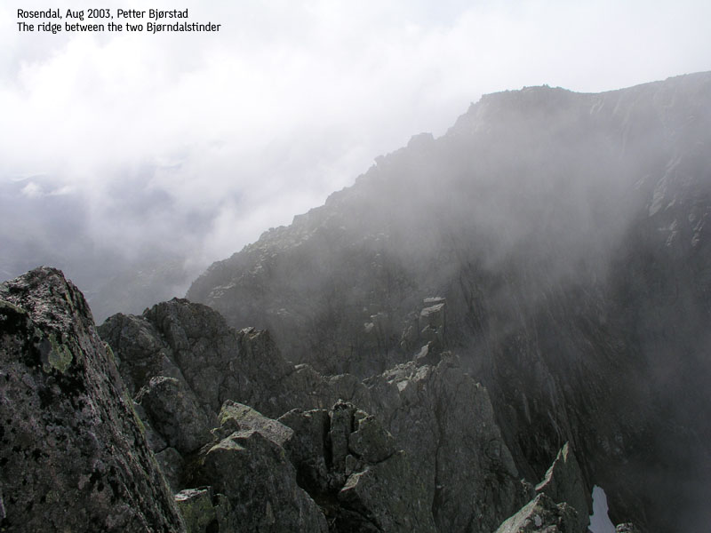
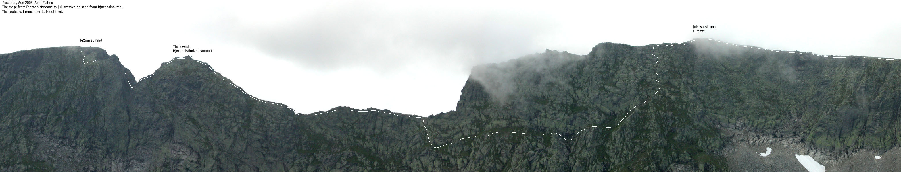
The ridge route across Bjørndalstindane to Juklavasskruna is a classic high ridge scramble route with tremendous views and exposure. In my opinion, this is the finest ridge walk in the entire Hordaland Fylke. Completing the whole ridge would start with a rappel down Melderskin and (most likely) continue with some pitches of climbing until the western Bjørndalstinden is reached. I can not state the difficulty of this route. The route described in this document hits the high ridge on the western Bjørndalstinden summit and continues traversing the ridge towards Juklavasskruna. All in all, 2Km (!!) of exposed ridgework, which surely will keep you mentally focused. This is a good alternative when time is essential. In addition, the route described in this document does not involve climbing above US class 3, which is considered scrambling.
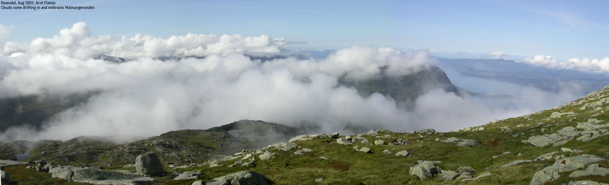
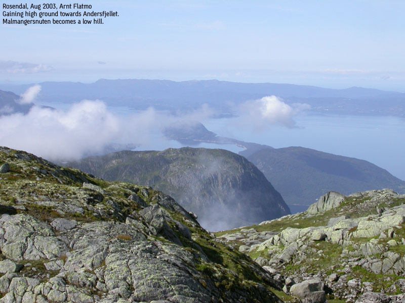
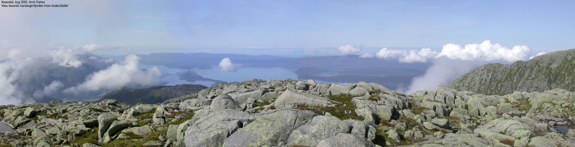
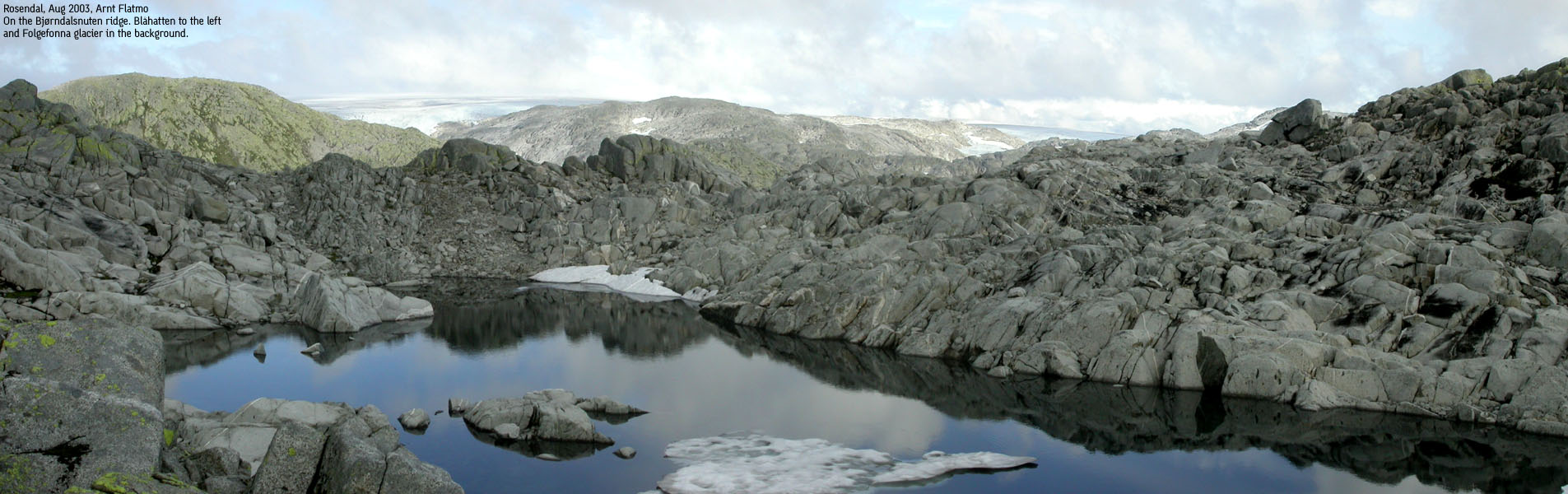
The route described here crosses Andersfjellet on the way to Bjørndalstindane and the Bjørndalsnuten ridge on the descent. Both these summits are named, but unranked mountains. This means they have a primary factor of less than 100m and are not considered to be separate mountains on this web site. They do however deserved to be mentioned. Andersfjellet provides a nice wiew towards Hardangerfjorden while Bjørndalsnuten offers a great view towards Folgefonna and the nearby mountains. Bjørndalsnuten also offers an exciting 1000m, much less exposed high ridge walk.
Heights
On the map, you will see the 1434m trig. point on Juklavasskruna. After correlating two GPS readouts, we have concluded that the highest point on this mountain is 1455m and is located SW of 1434m, on the narrow ridge towards Bjørndalstindane. The high point holds a distinct cairn and can be reached from the Juklavasskruna plateau through a short, but narrow ridge walk.
The western, and highest Bjørndalstind have a map height of 1426m. The second summit (further east) have no height defined on the map. We estimate this peak to be approx. 1420m. On the GPS vector map, the 1420m contour line is found on the summit, suggesting this peak is 1420m or higher.
The Bjørndalsnuten cairn (1201m) is located SW of the high point, which makes little sense. We estimate the high point to be approx. 1230m.
Primary Factor
Juklavasskruna has a primary factor of 325m towards the higher Folgefonna glacier. The saddle is found west of lake 1208m and the adjacent contour lines in the saddle are 1140m. The saddle height has been interpolated to 1130m.
The western Bjørndalstind has a primary factor of 96m towards the higher Juklavasskruna, and unfortunately, does not qualify for entering my list of Hordaland mountains. The adjacent contour lines in the Bjørndalstindane - Juklavasskruna saddle are 1340m, and the saddle height is interpolated to 1330m. For such a peak, one is tempted to use 300 feet instead of 100m, as 300 feet is 91,44m :) A GPS that rounds up or down to the closest 10m stated the saddle height was 1330m. This means that the saddle could be anywhere from 1326m to 1335m. Given 1326m, the primary factor would read 100m. This assumption is called a "soft rank".
As the height of the easter Bjørndalstinden is unclear, we can only suggest the approximate primary factor. My GPS map shows a saddle point measuring 1380m. Given a summit height of 1410m, this gives a primary factor of 30m.
Andersfjellet has a primary factor of 61m towards the higher Bjørndalstindane. The adjacent contour lines in the saddle north of the summit reads 1160m, and the saddle height is interpolated to 1150m.
Bjørndalsnuten has a primary factor of a modest 40m towards the higher Juklavasskruna. The adjacent contour lines in the saddle north of the (approx.) 1130m summit reads 1200m, and the saddle height is interpolated to 1190m.
Note: Class ratings are in reference to YDS (Yosemite Decimal System).
Note: The trail described below is not necessarily the easiest trail to this mountain.
|
Muradalen valley - all summits round-trip (summer/autumn)
|
|
Access
From Bergen, follow highway E16 (Oslo). At the Trengereid junction (approx. 25 minutes from Bergen), exit right onto highway 7. When you arrive Bjørkheim by the Samnangerfjord, drive through two tunnels, and exit right onto highway 48 (Tysse/Rosendal) immediately after the second tunnel.
Follow highway 48 to the Hardangerfjord (Mundheim), and exit right towards Gjermundshamn at the Mundheim junction. At Gjermundshamn, take the ferry to Løfallstrand across Hardangerfjorden. Some ferry routes make a stop at Varaldsøyni island. Make sure you get off at the right stop. Allow 2 hours for driving from Bergen to Gjermundshamn, and calling 177 (Norwegian short-dial for traffic information) for ferry departures might be a good idea. Onboard the ferry, obtain ferry route in the cafeteria.
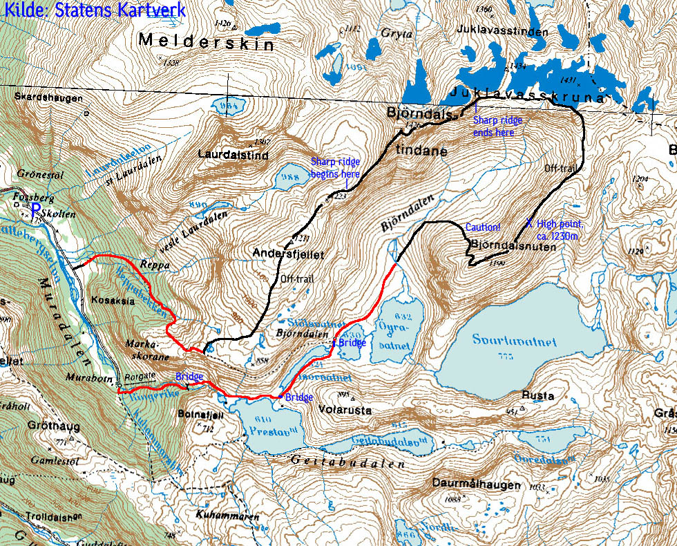
From Løfallstrand, exit right towards Rosendal. From the centre of Rosendal, exit left onto a paved road signed "Baroniet" (a historic building). At the first junction, go straight ahead and continue through the Baroniet gate (the road to the left goes to Kletta - the Melderskin trailhead). Continue on a gravel road passing Baroniet and follow this road up Muradalen valley. Drive on this road until you see a roadsign that prohibits cars and motorbikes from further driving. Shortly before, you find a small parking on the right hand side.

The route
To W. Bjørndalstind via Andersfjellet and the SW ridge
Follow the gravel road into Muradalen valley. Pass a gate, which you must lock. On a long flat pitch, you have three streams coming down on your left. Pass all streams and head on up along the last stream (the 3rd). In not too long, this stream forks (the left branch connects to the 2nd stream). Continue along the branch going to the right, and 50m later you should see the trail as it crosses stream 3 and continues on the ridge between stream 2 and 3. Follow this very visible trail as it rises to 820m.
On 820m, you see a couple of cairns. The trail will continue across the mountain and down to Bjørndalen, but you leave the trail now and head north-east towards Andersfjellet summit (1211m). Stay on the high ridge. The terrain is easy to follow.
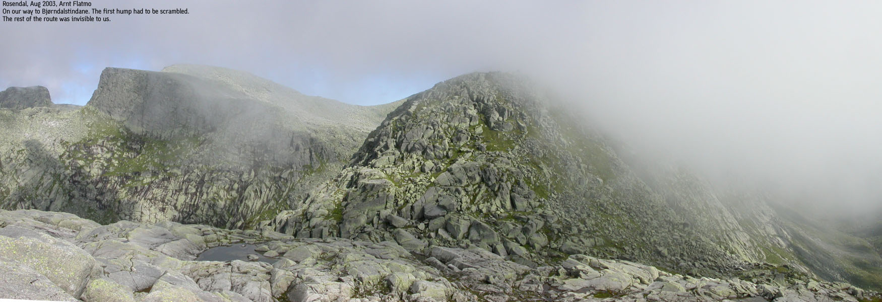
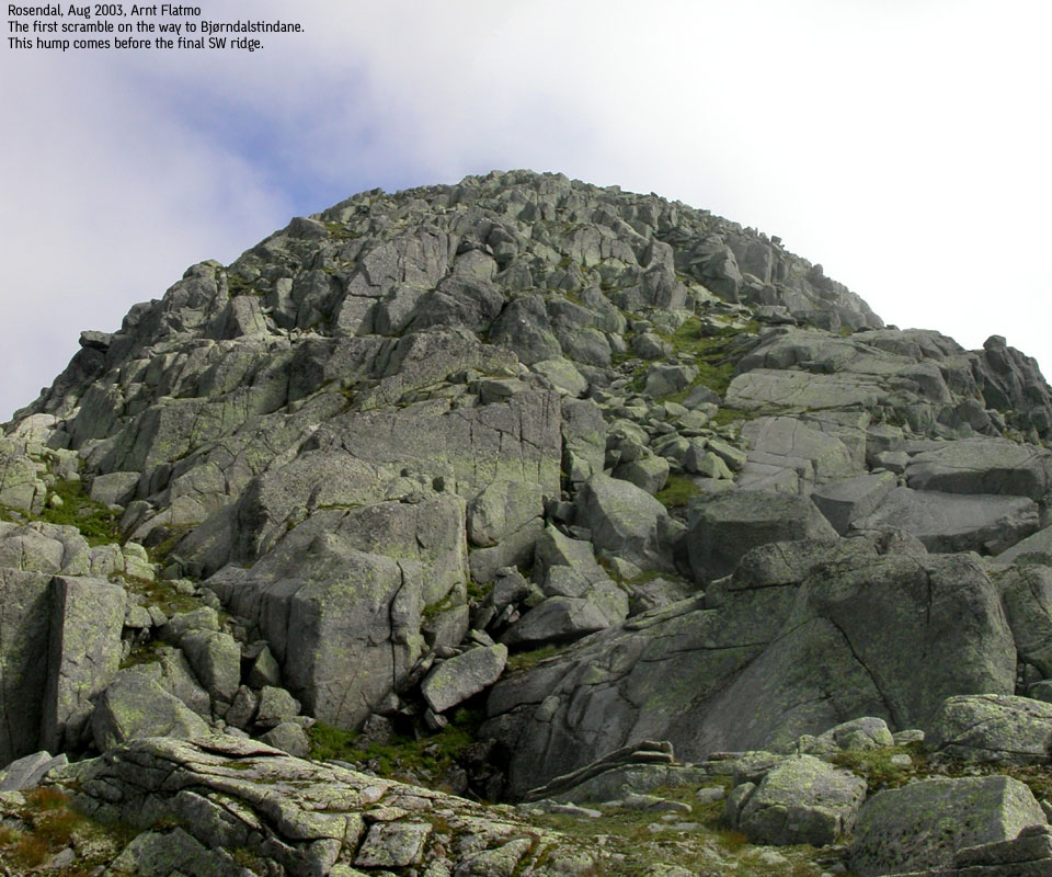
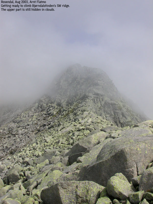
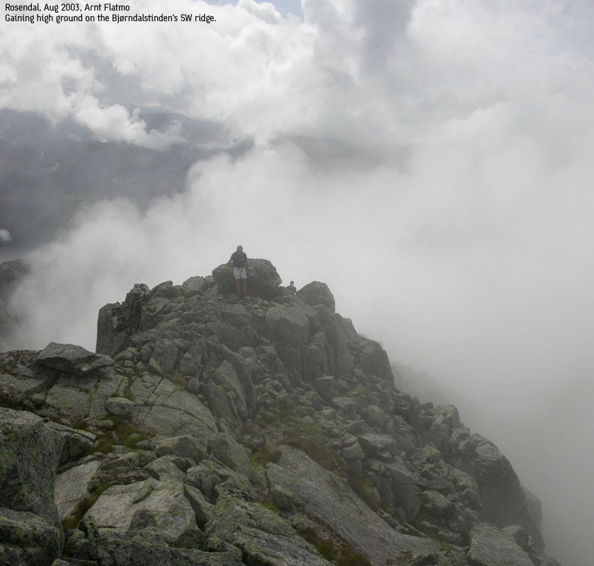
From Andersfjellet, head north down to the saddle between Andersfjellet and point 1223m. Follow a grassy pitch steep upwards and then through a corridor, or find a scramble route that suits your talents. It can quickly get steep! From 1223m, you have a large basin in front of you, along with the SW ridge towards the western Bjørndalstind. This ridge is intimidating, but offers the easiest access to Bjørndalstindane. The route up the SW ridge consists of multiple short class 3 moves. Another option is to go into the basin and onto the high ridge from Melderskin. The difficulty here is unknown to me, as it probably involves crossing over a deep notch before the summit can be reached from the west. This notch may require climbing.
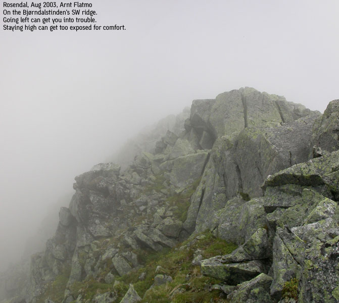
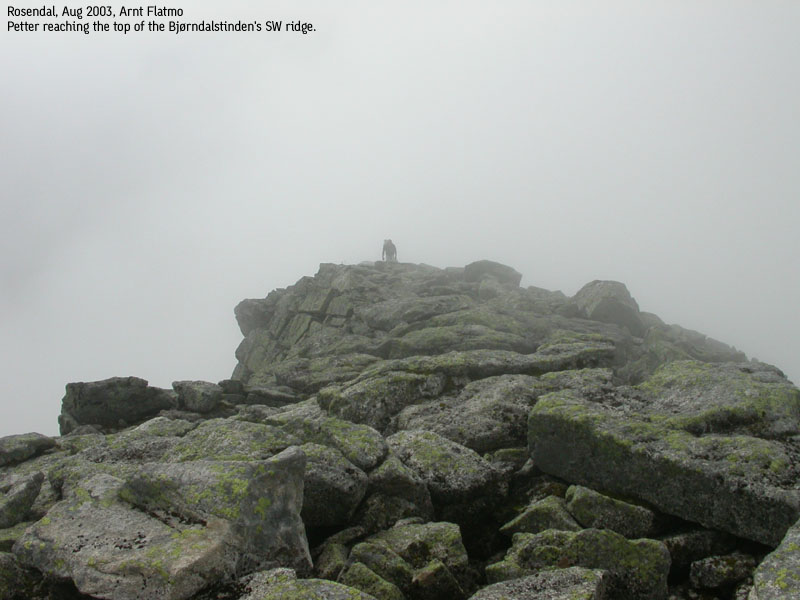
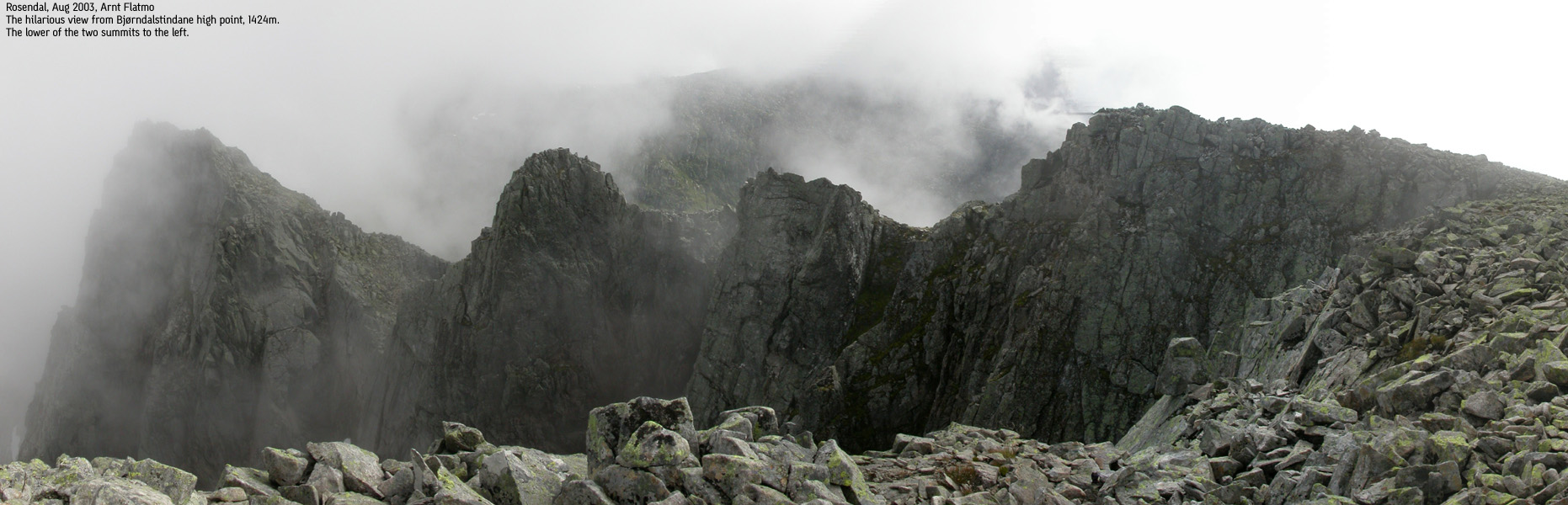
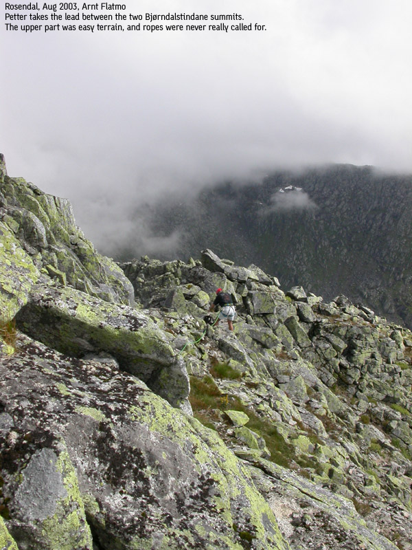
Early on the SW ridge, it is possible to bypass the initial obstacles by seeking left of the ridge and scramble up a grassy pitch that connects to the ridge. This grassy pitch should be obvious. However, the pitch is also steep and messy. Since the rest of the traverse involves narrow ridges with screaming exposure, you might as well get used to staying on the high ridge. When you reach 1370m, the ridge starts leveling out and provides an easy hike up to the 1426m summit which is marked by a proper cairn.
The traverse to Juklavasskruna
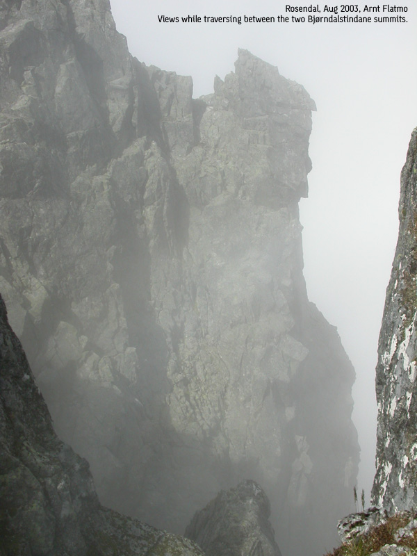
From the 1426m summit, you see a series of humps along the eastern ridge, connecting to the lowest of the two summits. The humps look downright scary, but are easily bypassed on the south side. The descent into the saddle between the two summits require caution when you scramble down the steep mountain side. This is class 3 terrain, but only a few short pitches can be said to be technical. If there is more than 1 person here, use a helmet or make good sure no one kicks off any loose rock. Climb steeply up to the lower of the two summits, which only has adequate room for 2-3 persons.
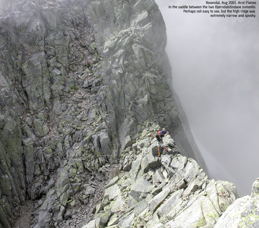
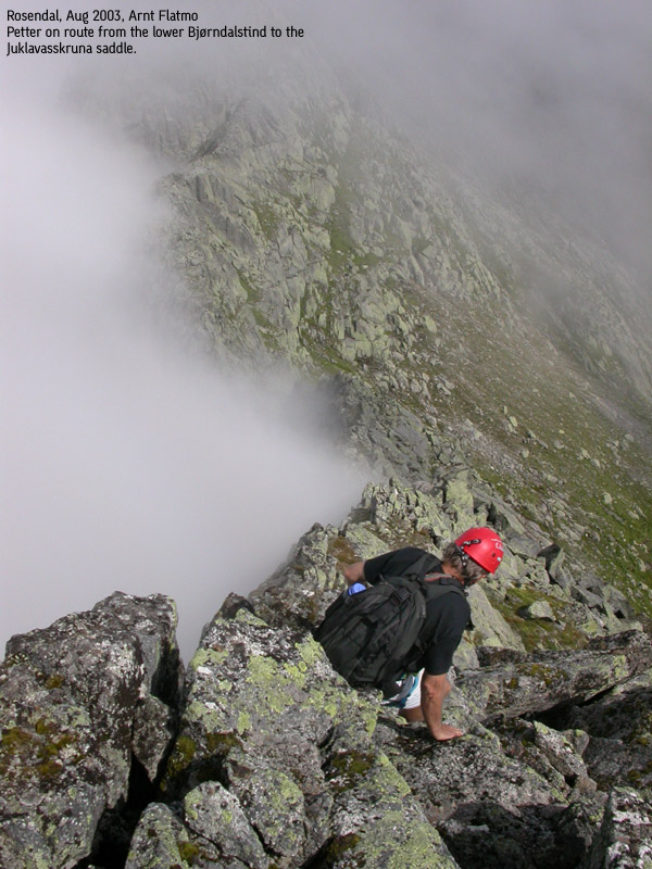
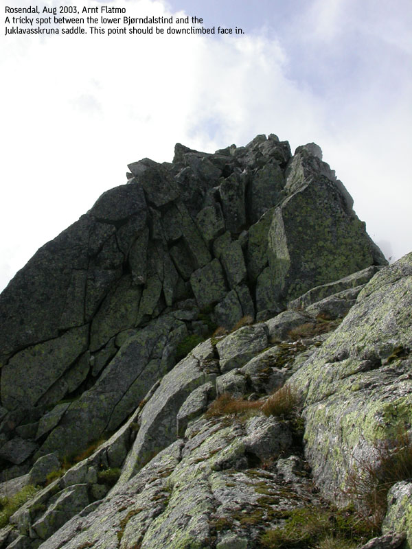
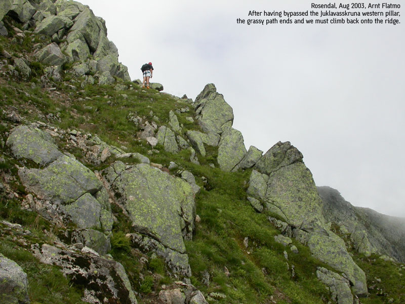
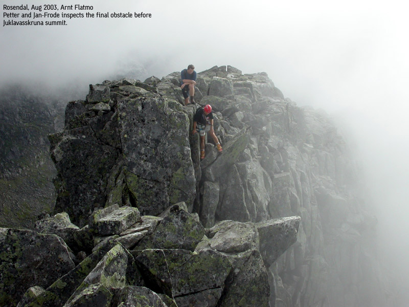
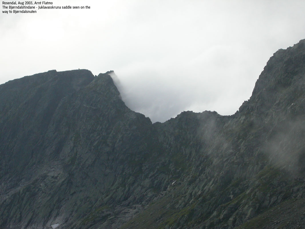
From the 2nd summit, the demanding traverse begins. Follow the ridge down to the Bjørndalstindane - Juklavasskruna saddle. The ridge is very narrow in places (less than 1 meter wide) and requires solid handholds. At least one point can be called tricky and requires a downclimb face in. As you approach the saddle, you see the awesome steep west Juklavasskruna pillar. If you're into climbing, this is your route up. If you prefer walking, then follow a grassy path that takes you around the pillar. Follow the grassy path as it gradually climbs up the south side of the Juklavasskruna ridge. When the grassy pitch ends, then climb directly back onto the ridge. You should now be 50-60m from the summit. Another spooky obstacle awaits before you reach the Juklavasskruna 1455m cairn. A deep crack in the cliff requires a downclimb (face in or out) on your left hand side. Technically, the moves are not very difficult, but the exposure is mind-boggling. Do not slip here.
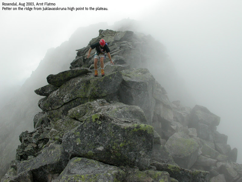
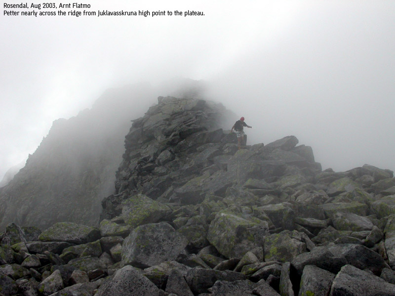
After celebrating on the Juklavasskruna summit cairn, complete the final ridgewalk (approx. 250m) to the Juklavasskruna plateau. Again, the ridge gets really narrow, and you need to make sure handholds/balance are good. Once on the plateau, the rest of the hike is easy in comparision.
Back to the trailhead
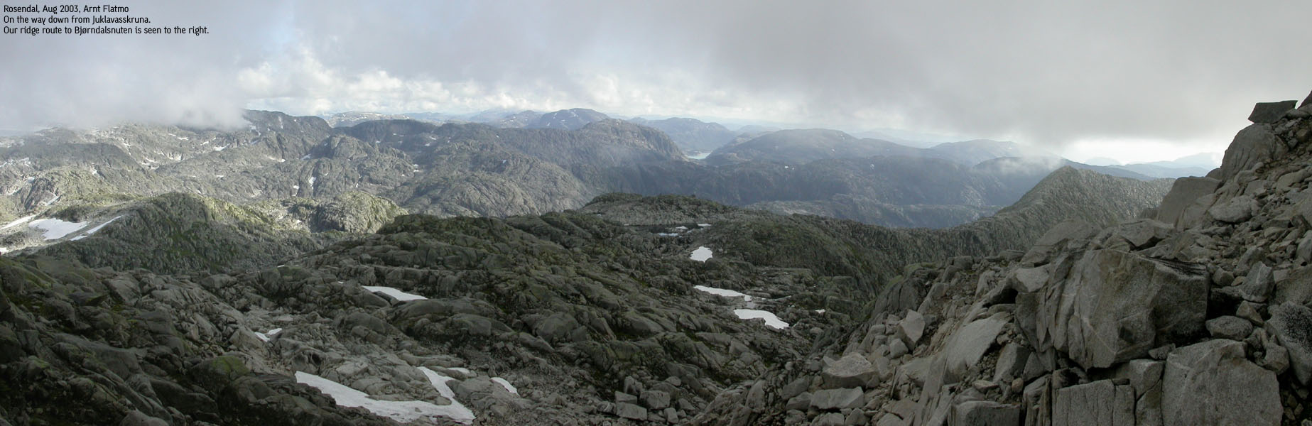
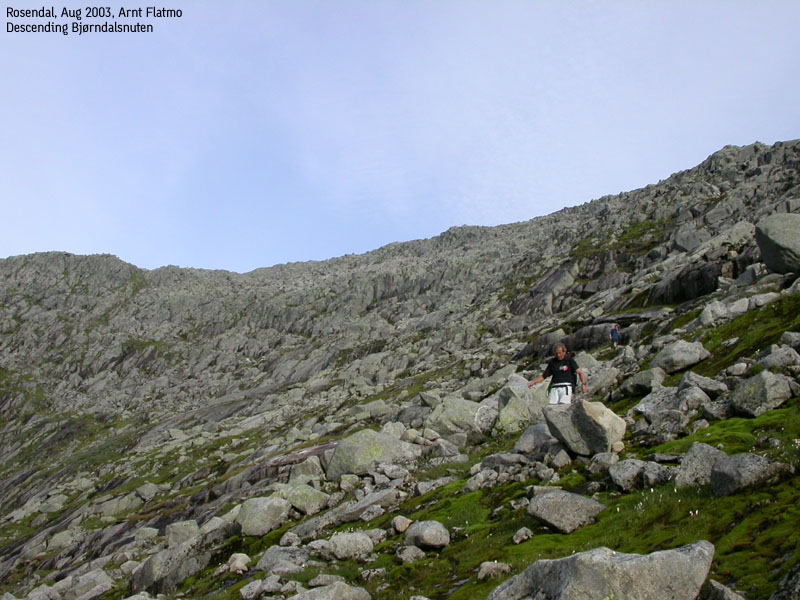
Visit the 1434m cairn on the Juklavasskruna plateau before you head south-east across the plateau and climb down to the Juklavasskruna - Bjørndalsnuten saddle. The climb down to the saddle isn't difficult, but the terrain is somewhat cumbersome. Then follow the ridge across Bjørndalsnuten until ridge end. The high point should be obvious, and is located before you reach the Bjørndalsnuten cairn which is located oddly on the ridge.
From the far end of the ridge, descend down to the valley via Bjørndalsnuten's north-west ridge. The descent requires routefinding to avoid troublesome parts. High on the descent, move towards the basin (right). In the middle of the descent, move towards the left. When you approach a band of flat rock (not exactly cliffs, but still equally troublesome) then make sure you find a good route down. There is at least one secure path. Once below these flat rocks, then shortcut the ridge down to the valley. These manoeuvers should hopefully work as a general guideline.
Once you cross the stream that drains towards the lake, you might spot a narrow path that you can follow all the way to the Bjørndalen cabins. Cross the river via a bridge and follow a trail that may not be on your map, running on the south side of lake Isorvatnet. At the far end of the lake, another bridge will take you across the river. Follow the trail to the west end of lake Prestavatnet. From the lake, the trail runs steep down the hillside. Wires can be used for support in the steepest parts. The trail continues across boulder and crosses the waterfall via a bridge. Once you've crossed the bridge, follow a forest trail all the way down to the road in Muradalen (Murabotn). From here on it is approx. 2,2Km back to the trailhead.

|
To Bjørndalstinden Petter and I had been talking about this traverse for quite some time, and this week-end we finally had the opportunity. Jan-Frode wanted to come along for the trip. He had given this ridge a shot earlier, but was turned down by ugly weather. The weather for this Sunday was supposed to be brilliant. We all expected the local fog to be burnt off by the time we got to higher ground. Due to late departing ferries from Gjermundshamn on Sundays, we didn't get going until 09:25AM. We very very excited to be on the way. We expected that the long rope and iron tools would solve most of the challenges along the way, but we really had no clue on what kind of challenges we would encounter. We would just have to deal with them along the way. The first challenge was to find the trail from Muradalen. After briefly messing around in the forest, we adjusted the course and found the trail towards Andersfjellet/Bjørndalen. It was a hot day, and we took our time up the mountain. High on Andersfjellet we scouted for a possible descent route. The initial plan was to descend in Bjørndalen's inner basin. It looked steep, but doable. And in any case, we had the rope. Higher on Andersfjellet, we modified the plan and decided to descend Bjørndalsnuten's north-west ridge. The ridge seemed slightly less steep, and we could collect another mountain top, although this one not ranked. Once on Andersfjellet summit, it was clear that the fog would be a slight problem. We had no view of the Bjørndalsnuten SW ridge, which made planning somewhat harder. The second option was to get on the Melderskin - Bjørndalstindane ridge, but Petter believed a notch would cause more problems on that route. We decided to get lucky on the SW ridge. First, the 1223m point had to be passed. The climb to the top was steep, but unproblematic. But at least we got into scrambling mode. I was overeager and got way ahead of the others on my way to the SW ridge. The initial part looked ridiculously steep and I decided to bypass these problems and follow a grassy pitch on the left hand side. Of course, Petter and Jan-Frode took on the ridge directly, and I got a bit nervous about getting stuck in the steep side below the ridge. I fumbled around for a route up, and had the sensation that everything was vertical. Finally, I made it back on to the ridge, and watched Petter and Jan-Frode take on the various obstacles further down on the ridge. After some further light scrambling, we were in easy terrain and entered the highest of the Bjørndalstindane peaks at 13:35PM.
The traverse I was full of joy of reaching the summit, and after one glance towards the "humps from hell", also known as the further route, I just wanted to go home. I couldn't believe that this sort of terrain could exist in Hordaland, where 99.8% of the mountains are friendly and easily traveled. The fog that dressed the mountains only added value to the atmosphere. I was perhaps relieved of the fact that I didn't get to see valley floor. After a meal on the summit, we decided to rope up. It seemed to be the kind of terrain where the rope is your friend. The south side of the "humps from hell" was quite friendly, and I cursed the rope after only 5 minutes. The distance between us was too long, and the echo distorted any vocal communication. If there was to be any sense in the rope, it should be tight when the leader climbed down. This also meant that I had only seconds to complete the awkward moves before the rope pulled me further. And once down in the saddle between the two Bjørndalstindane summits, we decided to put the rope back into the rucksack. As the others were in "high ridge mode", it felt like cheating taking the sensible route around obstacles. So, in the saddle, I started climbing the high ridge towards the 2nd of the two summits. The ridge was narrow indeed. I did not find words in my vocabulary to express the exposure down to my left. For a moment I got stuck on the ridge, standing on my knees, trying to figure out an answer to the obvious question - Why? I acclimated fast and continued up the ridge without further glitches in the psyche. The 2nd summit was by far the narrowest peak I have ever been on. Petter and I crowded the summit. I only got a glimpse of the route ahead. It looked narrow. And then it disappeared into the big white nothing. Jan-Frode was leading on across the ridge towards Juklavasskruna. Swiftly, he passed over obstacles that was more time consuming for Petter and myself. At one point on the ridge, we were downclimbing face in while Jan-Frode was giving us suggestions on where to put our feet. How did he swing down here without building up a queue? When we finally reached the western Juklavasskruna pillar, the confidence I had built up swept away like a newspaper in a storm. The pillar was not only high, it was ugly-steep. I looked towards an inviting grassy pitch, bypassing the pillar, hoping the rest of the team felt the same way. We could obviously climb this thing using ropes and belays, but it would take considerable time. If there was a way around this thing, then why not. The fog (and a poor map resolution) caused some uncertainty whether this pillar was the 2nd of the two Bjørndalstindane summits. But then Petter realized that this had to be Juklavasskruna, and exactly the place where a friend of his had tried to rappel down, only to be hanging high above ground with no more rope. His friend had told him that they had to climb back up, and bypass the pillar on the south side. The grassy pitch we were looking at could very well be that route. The grassy pitch had its degree of exposure, but in dry conditions, the route felt safe enough. We gradually climbed upwards until there was no more grassy route to follow, and then climbed directly onto the ridge. In order to gain the ridge, we could choose between climbing through a V-crack, or in a more creative fashion directly onto the ridge. I had great fun in manoeuvering through the V-crack, but Petter didn't like my recommendation and wondered why I had put him in this situation. Jan-Frode decided to climb up outside this crack. I could see a cairn 50-60m away and started a solo journey before Jan-Frode had reached the high ridge. I wanted to take some photos as they came along the narrow and airy ridge. Just before the summit I stared down to a deep notch in the ridge. The climb down had an insane exposure. I decided to downclimb face out. When I was parallel to the ridge (below me was just the rock I was standing on, and nothing else), I prepared to move onto the ridge through a gentle swing. I saw a chance that the move could fail, and made sure I had the right holds. The first move failed and I felt significant stress come upon me as I bounced back on the narrow rock I was standing on. This was an interesting moment. It was just me and this tricky move. The others hadn't arrived yet. Only one year ago I would have been busy with cursing everyone, finding every excuse to turn around, but having to complete the job anyway with a "I'll never hike mountains again!" mindset. Now it was just me and the problem. I felt a strong sense of satisfaction noticing the heart beating at its normal rhythm. The second swing was successful, and 16:05PM I sat down on the Juklavasskruna high point cairn. The others came across the ridge and was highly surprised to find this type of obstacle, so close to the summit. After measuring the height using two GPS receivers, we concluded that Juklavasskruna was 21m higher than what we had perceived.

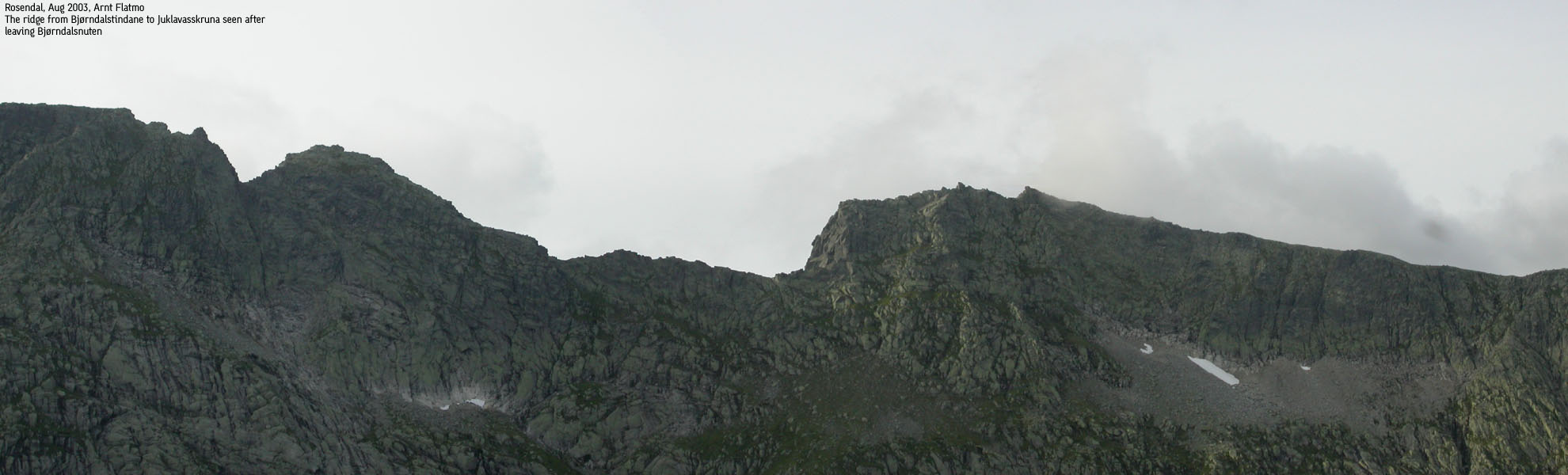
The traverse seen from Bjorndalsnuten
The "thriller" finish The remaining ridge towards the Juklavasskruna plateau was no easier than the ridgewalks we had done so far. But soon we were on the plateau, and stopped by the 1434m cairn, only to verify that this point was as high as the map stated. Then we headed across the plateau, on the way towards Bjørndalsnuten. We had only carried one litre of water each, and 1 litre/7 hours is way too little. When we found running water on the Juklavasskruna plateau, I almost fainted after satisfying the thirst. I had trouble with both vision and balance. After gaining self-control, I concluded that there was nothing wrong with me. The water was just "THAT GOOD". We scrambled down to the Bjørndalsnuten ridge and started to move across the ridge. We reached the Bjørndalsnuten high point 18:02PM and I asked Petter when the last ferry was departing from Løfallstrand. 22-something, he replied. We still had a long way to go, and the overall team tempo was decreasing. Before us, we had a 200m climb back onto the trail over Andersfjellet, which we knew would be time consuming. At 19:15PM, on the way down from Bjørndalsnuten, Petter presented "Plan B". Plan B was about making it across the south side of lake Isorvatnet. At the far end of the lake, we could follow the trail from lake Prestavatnet down to the Muradalen valley. This meant no upwards hiking, which would be of great benefit, time-wise. The concern was that we had to cross the river from lake Stølsvatnet to gain lake Isorvatnet's south side (the north side was way to steep, and this is where the trail to Andersfjellet ran). Then, the river from lake Isorvatnet had to be crossed to get onto the trail to Muradalen. Petter suggested that I ran down to the lake and looked for a way across. If I could make it down to the valley, then I could go and get the car and drive it to the end of the valley (ignoring any signs prohibiting traffic). If I couldn't make it across the lake, then I was to come back and join the group. Missing the last ferry involved a high probability that we would have to drive to Bergen via Hol-Aurland. This would take 6-7 hours, and was clearly the very last option. I ran down to Bjørndal and uttered sounds in pure joy when I discovered a bridge across the river and a visible trail along the south side of lake Isorvatnet. My heart rhythm involved some extra beats when I was approaching lake Prestavatnet. The river was raging. Would there be a second bridge? Yup, there it was. The trail down along the waterfall from lake Prestavatnet was cumbersome, and wires provided welcomed handhold. Across the boulder section below I had to look hard for the trail. But by 20:35PM, I was down in the valley and ran the remaining 2,2Km for the car. I called my colleague Tore "always on-line" Larsen and asked him to look up the last ferry from Løfallstrand on the hsd.no web-site. As I was on the border of cellular coverage, I said I would call back for the answer when the others had come down from the mountain. I wasn't sure how fast the others were advancing, and decided to head back up with a headlight. If darkness came upon them, they would have problems following the trail down the waterfall. At 21:15PM, I met Petter and Jan-Frode about 200m above Muradalen. I was very happy to see them. Perhaps we would reach the ferry after all. We were down by the car at 21:35PM and I dropped them off at their car by the trailhead 21:40PM. On the way to the ferry, I called Tore. He told me that the last ferry left at 22:00PM. We arrived at Løfallstrand 21:51PM. The hike took 12 hours, 10 minutes. How's that for cutting it close?
|
Move cursor to read notes, and click on the images to see full version.
Some of the thumbnails may have been cropped to fit the format.
Pictures are presented in the order they were taken.
The route to Bjørndalstinden


No Javascript:
1 2 3 4 5 6 7 8 9 10 11 12 13 14 15 16 17 18 19 20 21 22 23 24 25 26 27 28
The traverse


No Javascript:
1 2 3 4 5 6 7 8 9 10 11 12 13 14 15 16 17 18 19 20 21 22 23 24 25 26
The descent


No Javascript:
1 2 3 4 5 6 7 8 9 10 11 12 13 14 15 16 17 18 19
 Other hordaland mountains
Other Kvinnherad K. mountains
westcoastpeaks.com
Other hordaland mountains
Other Kvinnherad K. mountains
westcoastpeaks.com

