
|

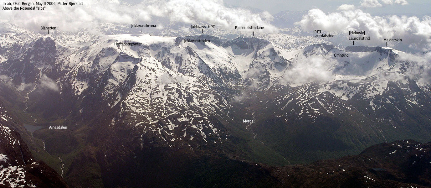
Rosendal alps seen from the air(No Javascript) |
Hordaland's finest (and most challenging) ridge walk runs from Melderskin above Rosendal via Omntinden, Inste Laurdalstind, Bjørndalstindane and Juklavasskruna. Bjørndalstindane and Juklavasskruna are presented here while this page describes the western mountains.
Melderskin is a mountain for the people, and a marked T-trail takes you safely from Rosendal to the summit. Omntinden, Inste and Heimste Laurdalstind are more challenging mountains, and Heimste Laurdalstind has a spectacular, narrow saddle that you must pass on the normal route to the top. Omntinden and Inste Laurdalstind are much easier, when approached from the easiest sides.
The ridge from Melderskin to Juklavasskruna is not technically very difficult in late spring/summer, but in winter this route is the undisputed (my opinion) winter traverse in all of Hordaland. Ropes are necessary as parts of this ridge are both narrow and extremely airy. Skiers who like steep hillsides and couloirs enjoy the terrain around the north sides of the Melderskin - Juklavasskruna ridge.
Note that the local (Rosendal) name is Omnatind, not Omntinden. This will be corrected in a future revision of the document and pictures. Many thanks to Kåre Eik, providing me useful local information.
Melderskin (M711: 1426, Ø.K: 1425,54m) has a primary factor of 196m towards the higher Juklavasskruna. The saddle is found between Omntinden and Inste Laurdalstind. Ref. the 1214-I Kvinnherad/Rosendal map (20m contours), you cross the 1240m contours on the high route, but not 1220m. The saddle height has been interpolated to 1230m. (My GPS reading in this saddle was 1227m)
Omntinden (M711: -, Ø.K: -, GPS: 1388m) has a primary factor of 60m towards the higher Melderskin. The saddle is found between the two tops. Ref. the 1214-I Kvinnherad/Rosendal map (20m contours), you cross the 1320m contours on the high route, but not 1300m. As such, the saddle height should have been interpolated to 1310m. Instead, I have used my GPS readings from the top (1388m) and the saddle (1318m).
Inste Laurdalstind (M711: -, Ø.K: -, GPS: 1389m) has a primary factor of 104m towards the higher Bjørndalstindane. The saddle is found between Inste Laurdalstind and V. Bjørndalstinden. Ref. the 1214-I Kvinnherad/Rosendal map (20m contours), you cross the 1280m contours on the high route, but not 1260m. I have used my GPS reading at the top (1379m) and chosen 1275m (conservative interpolation) as the saddle point (I have not been in this saddle).
Heimste Laurdalstind (M711: 1307m, Ø.K: -) has a primary factor of 57m towards the higher Inste Laurdalstind. The saddle is found on the ridge between the tops. Ref. the 1214-I Kvinnherad/Rosendal map (20m contours), you cross the 1260m contours on the high route, but not 1240m. The saddle height has been interpolated to 1250m.
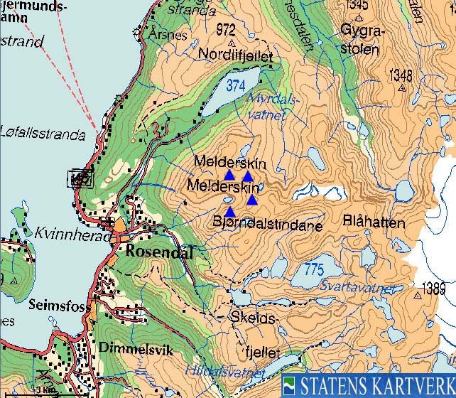
The 1214-I Kvinnherad (1:50 000) map is now named 1214-I Rosendal. In addition to the 1215-II Varaldsøyna (1:50 000) map, you may also refer to the "Folgefonna-Hardangerfjorden" (1:100 000) turkart map. For this web-page, I have assembled the following maps, covering the area:

(No Javascript) |

(No Javascript) |
There are 3 logical trailheads that offer access to these mountains. I have not been to all of them, and will only describe the ones I know.
Common for all is the Kletta/Highway RV48 junction in the centre of Rosendal. From Bergen, follow highway E16/RV7 towards Oslo. At Trengereid outside Bergen, turn right onto RV7 and follow this to the RV7/RV48 junction shortly after Bjørkheim by Samnangerfjorden. Turn right onto RV48 and follow the road to Mundheim by Hardangerfjorden. Turn right at Mundheim and continue to the ferry at Gjermundshamn. It takes approx. 2 hrs to drive from Bergen to Gjermundshamn. Note that you can also travel from Bergen to Rosendal via bus and/or express boats. Check the hsd.no web-site for more information.
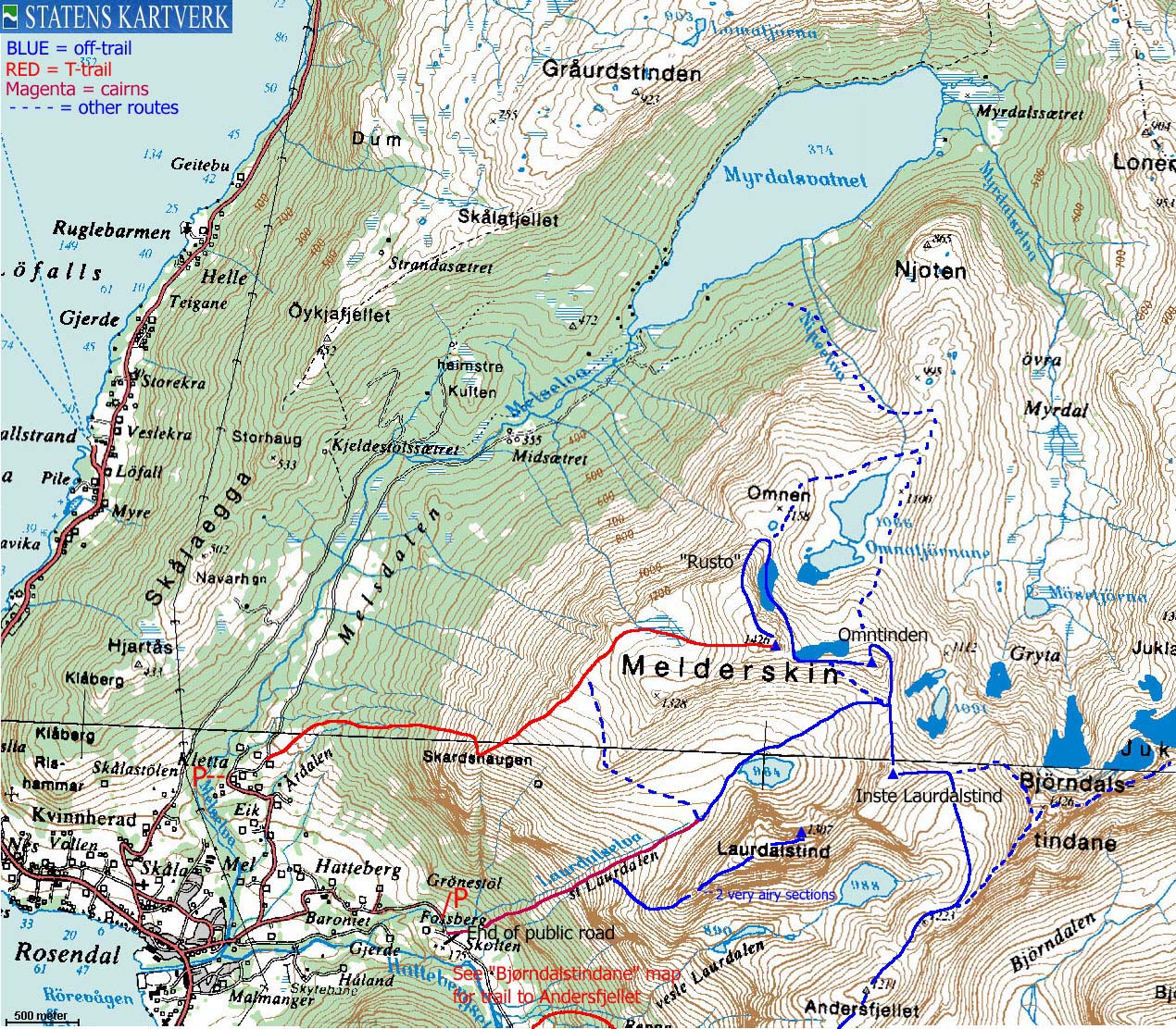
Kletta
This is the trailhead for the normal route to Melderskin.
From the Kletta/RV48 junction in Rosendal, follow signs towards Kletta. After approx. 600m (after you've crossed the river) the road forks. Turn left (the other road leads to Baroniet - "The Barony"). Continue up to Kletta, approx. 1,3Km from the fork. Find parking on the left hand side of the road.
Muradalen
This is the trailhead for Heimste Laurdalstind, and offers also access to the Omntinden - Juklavasskruna ridge.
From the Kletta/RV48 junction in Rosendal, drive approx. 600m to a road fork. Go straight ahead (right), pass Baroniet and drive until you see the sign that prohibits further driving into Muradalen valley. This is approx. 1,6Km from the road fork. There is a small parking area just before this sign.
Myrdal
I have not hiked from Myrdal, but the road runs up to Kletta (see above) and continues as a forest road, locked by a gate just after Kletta. If you want to hike Melderskin via the NW ridge (Rusto), you may consider hiking from Lake Myrdalsvatnet and up via Nipeelva river.

T-trail from Kletta to Melderskin
Assuming you parked at the regular parking area at Kletta; continue approx. 300m along the road until the road forks (you will see the Melderskin trailsign). Go to the nearest farm and continue up the tractor road that begins by the farm. Pass a gate and follow the T-trail all the way to Melderskin summit.
This is a straightforward class 1 trail. The distance from the trailhead to the top is just above 4Km. Kletta is approx. 150m elevation and the total vertical gain is approx. 1280m. Depending on your shape, allow up to 4 hours for the ascent and 3 hours for the descent. Very fit hikers will reach Melderskin in 2 hours. Fit hikers will do this in 3 hours, and others may need more. This estimate includes time for short breaks. Take your time.
In winter and early spring, steep snow in "Skarsklyp" (the point where you enter the SW ridge above Skar[d]shaugen) may call for the use of ice-axe and crampons on the normal route to Melderskin.
Return your ascent route, or hike down the NW ridge called "Rusto" (source: Kåre Eik) if you aim for Lake Myrdalsvatnet or want to continue towards Omntinden. A more direct approach to Omntinden is through a couloir directly from the Melderskin summit. Although some ski down here under good snow conditions, others may choose to rappel down or climb using ice-axe and crampons. If you aim for the Laurdalen valley, you can a) find a route down from the Melderskin - Omntinden saddle, b) Go around Omntinden and find an easy route down from the Omntinden - Inste Laurdalstind saddle, or c) descend via the 1328m sub-peak down to 1100m elevation and then into Laurdalen.

All summits from Muradalen via Store-Laurdalen
From the end of the public road in Muradalen, head towards the ruins of an old farmhouse. Cross the creek and look for a small boulder field. Search the right hand side of the boulder field for the "Store-Laurdal" trailsign. From here on, follow cairns all the way up to the valley floor with Laurdalselva to your left. Higher up, you get another stream to your right.
Do make sure that you find the cairns. This will save you from a lot of problems. The lower forest is steep and in a couple of places, you need to drag yourself by holding on to trees. The overall route is quite trivial.
Heimste Laurdalstind
Once in Laurdalen, you have Heimste Laurdalstind up to your right. You can reach the summit without using ropes, but the ascent is extremely airy in two narrow sections. Moving on from the summit, a rappel is normally required to reach the Heimste - Inste Laurdalstind saddle, unless you find a route facing Vetle-Laurdal and climb back on to the saddle. It is not possible to ascend Inste Laurdalstind from this saddle, unless you are a skilled climber. From the saddle, descend directly down to Lake 964m in Laurdalen.
I have only ascended Laurdalstind via the SW ridge from Laurdalen. The ascent is in dry conditions rated to class 3. With snow, the two narrow sections may appear even more difficult. Read the trip report here.
Inste Laurdalstind
Proceed up Laurdalen valley and stay left of Lake 964m. Head directly up a hill that tops out on the Omntinden - Inste Laurdalstind ridge. Turn right and head up to Inste Laurdalstind. In winter and early spring, this ridge will seem more airy the closer to the top you get. If you have to walk on snow, ice-axe and crampons are mandatory.
Omntinden
Descend back to the Omntinden - Inste Laurdalstind saddle. You can reach Omntinden in two ways. Either aim directly for the Melderskin - Omntinden saddle (with Omntinden up to your right) or pass Omntinden to the east and ascend the summit from the north side.
In winter/early spring, be aware of avalance hazard. Both sides are steep. In snow-free conditions, be aware of loose rock and moving boulder. The sensation of "air" will dramatically decrease in dry conditions, and more solutions (routes, handholds) will appear. The northern side of Omntinden is more friendly, and people ski down from this top.
Those who are looking for a real challenge may attempt to climb Omntinden directly from its base on the Omntinden - Inste Laurdalstind saddle.
Melderskin
Follow the Omntinden - Melderskin ridge towards a couloir that runs all the way up to the summit cairn. The snow conditions will determine if you can climb up here. If this couloir is not what you are looking for, then descend along Melderskin's east face until you reach the NW ridge ("Rusto"). This ridge is similar to the one up to Inste Laurdalstind, and is quite airy near the top before the snow melts away. Proceed up to the Melderskin summit cairn and descend the normal route towards Kletta.
If you want to get directly back to your car in Muradalen, then consider descending into Laurdalen a bit SW of point 1328m (SW of Melderskin). From approx. 1100m elevation, the terrain down to Laurdalen is quite gentle.

The mountains from Muradalen via Vetle-Laurdalen
Refer to the Bjørndalstindane page for this trailhead. Instead of following the ridge directly to Bjørndalstindane, walk from Andersfjellet to the basin between Bjørndalstindane and Inste Laurdalstind. I have not walked into the basin, but this should be trivial (off-trail) terrain.
Other hordaland mountains
 Other Kvinnherad K. mountains
westcoastpeaks.com
Other Kvinnherad K. mountains
westcoastpeaks.com