
|

Geitanuken central, dominated by Høgstefjellet(No Javascript) |
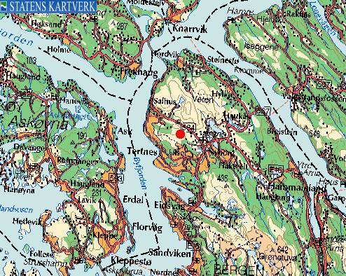
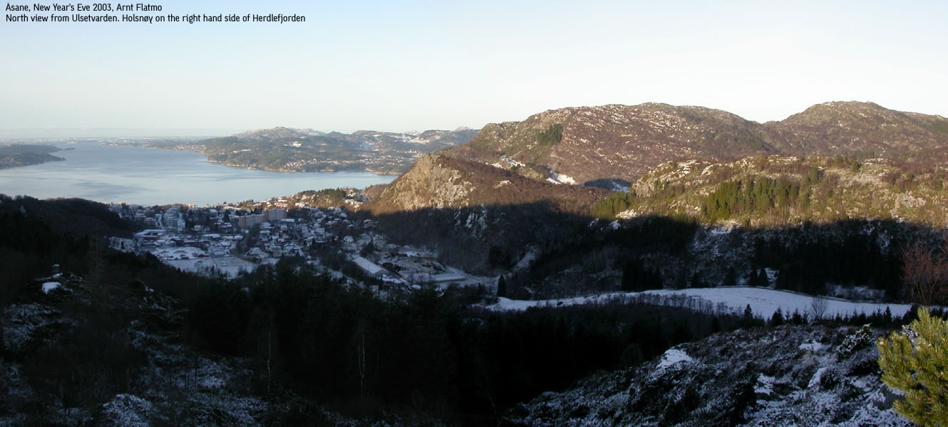
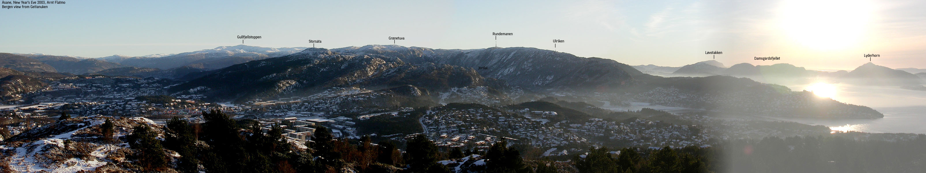
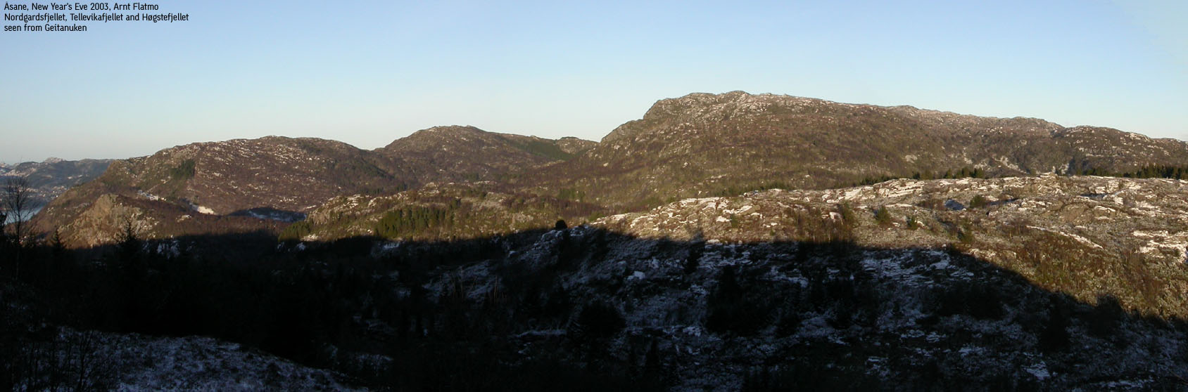
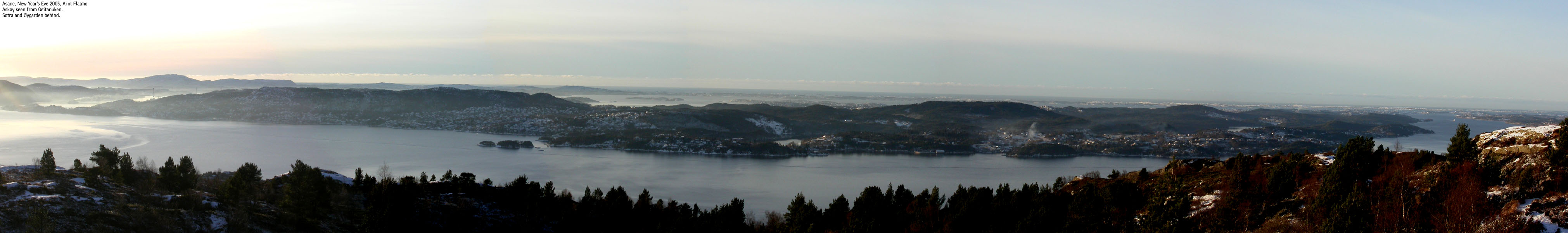
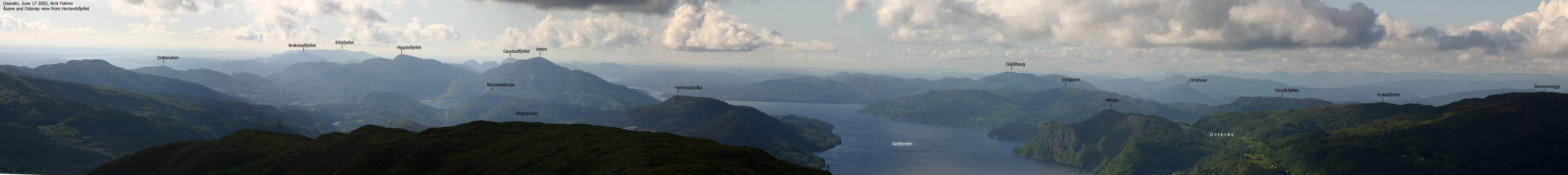
Geitanuken is located near Åsane, just outside the city of Bergen. You will find a good trail system which is extensively used by hillwalkers. From the top, you have a panoramic view towards Bergen, Sotra, Askøy and Holsnøy. The neighbour Høgstefjellet takes away most of the eastern views. Geitanuken is very accessible to the public, both in terms of trail length, quality and number of trails. A very good option for a hike for the family. From all the trails, I have described a hike from lake Ulsetstemma to Geitanuken via Ulsetvarden.
Geitanuken (M711: 305m, Ø.K.: 304,53m) has a primary factor of 172m towards the higher Høgstefjellet (464m). The saddle is found just east of Toppefjellet and north of lake Ulsetstemma. Ref. Økonomisk Kartverk (5m contours), you cross the 135m contours on the high route, but not 130m. The saddle height has been interpolated to 133m.
Note: Class ratings are in reference to YDS (Yosemite Decimal System).
Note: The trail described below is not necessarily the easiest trail to this mountain.
|
Ulsetstemma - Ulsetvarden - Geitanuken (summer/autumn)
|
|
Access
From Bergen, follow highway E16/E39 towards Oslo. When you arrive Åsane, exit left towards Salhus in the first roundabout (12,1Km from the Danmarksplass traffic junction in Bergen). Follow the Salhus road for approx. 400m. Then turn right towards Salhus. You've been on highway 564 since you left highway E16/E39. Continue on the Salhus road for approx. 1,2Km and locate a small turnout on the left hand side (room for 2-3 cars). This is just before the drain from lake Ulsetstemma crosses the road. If you pass a large building on your right, you've driven a bit too far.
The route
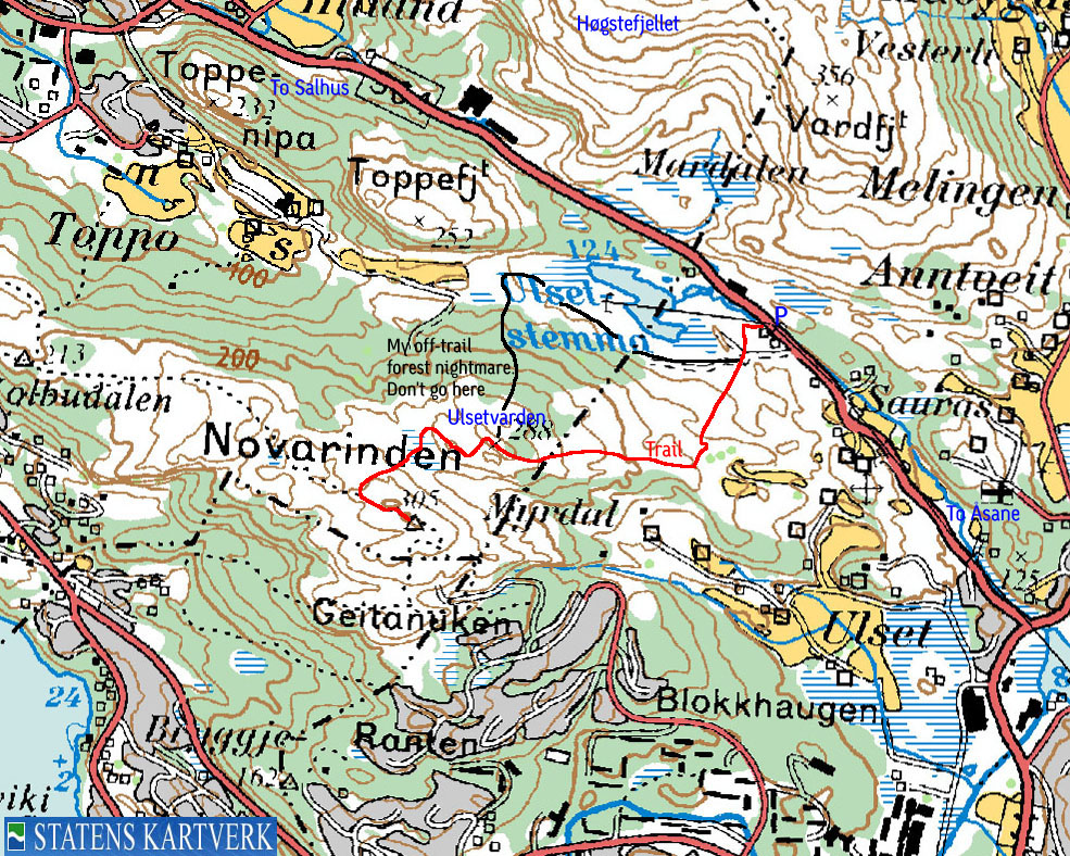
Follow the visible trail approx. 60m and cross a gate. The trail turns sharp left and runs southbound, parallel to the fence. After 130-140m, the main trail you're on turns right and runs along lake Ulsetstemma to the left of the lake. Do not follow this trail.
Instead, follow a smaller trail that will take you towards the ridge ahead of you. The trail up to the ridge runs for approx. 400m, and turns westbound on the ridge just after the powerline closest to the ridge.
Follow the trail up the ridge for 600-700m to Ulsetvarden (288m). You see Geitanuken further southwest, and the trail should be obvious. The trail runs down to a ridge between Ulsetvarden and Geitanuken, in northwest direction. Then the trail turns southwest and takes you down to the valley between Ulsetvarden and Geitanuken. You arrive the Geitanuken ridge (Novarinden) approx. 240m northwest of Geitanuken. Follow the ridge to the summit. The summit is marked by a marker painted in red and white. There is also a large transmitting antenna on the summit. Descend your ascent route if you have the car at lake Ulsetstemma.
It was high time I did the Geitanuken hill. It was the only hill on the Bergen peninsula that I hadn't been to, and this was a symbolic hike on the last day of 2003. The weather was brilliant. Sunshine and a thin layer of snow. I had called my colleague Jan Kåre Aasebø and asked for trail instructions. He knows this hill inside out. I found the trailhead straight away and left the car 12:10PM.
The dog was busy sniffing tracks and forgot to do the ususal sit-down at the start of the hike. The route to Ulsetvarden was obvious. Up to the ridge and then to the right. I decided to make this my return route, as I discovered a trail along lake Ulsetstemma. I was convinced I would find "dozens" of trails running up to Ulsetvarden from this major trail.
This was a false assumption. If there were any paths up through the forest, then the snow made them invisible. After a while, the major trail vanished, and I was more or less off-trail, wondering what this was all about. I was now just south of Toppefjellet and decided to end the search for a forest trail. Ahead of me was dense forest, and I knew this would be an annoying experience. The forest was so dense that I had to crawl on the ground, avoiding the sharp branches from the trees. The dog took interest in every hole in the ground and the forest adventure took its time. When I returned home, I found that I was only 95m away from a trail running up the forest....
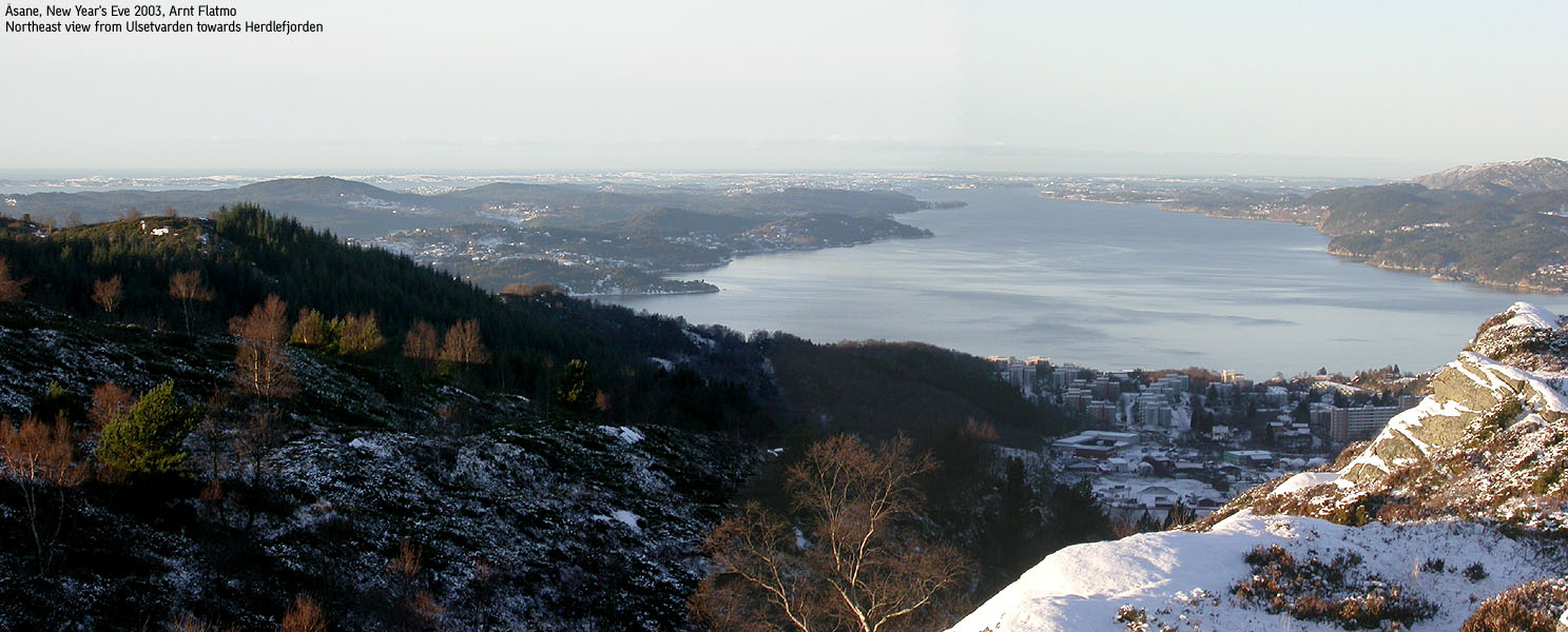
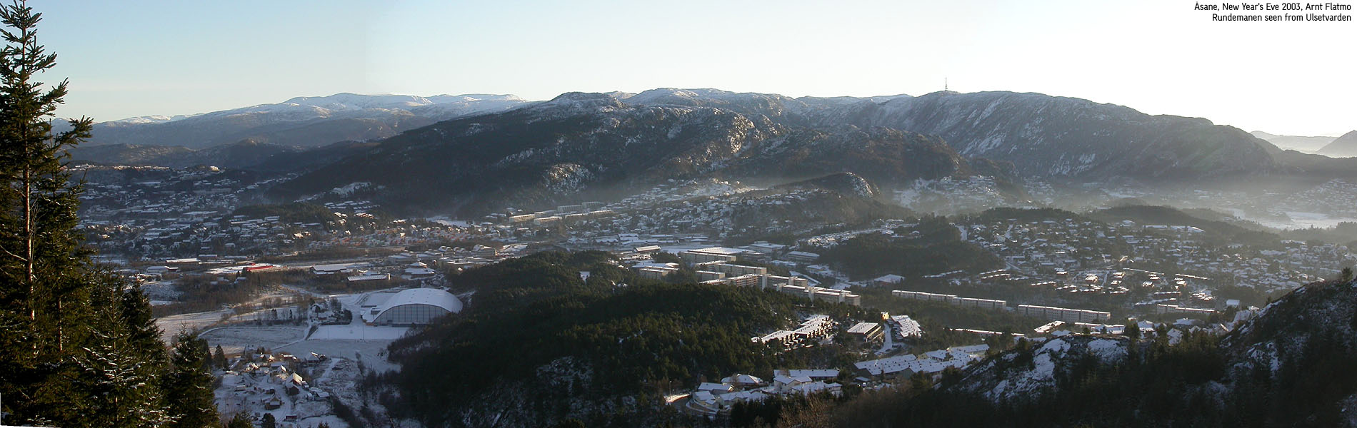
Finally, I saw blue sky behind the trees, and realized this misery would soon be over. We arrived Ulsetvarden from the north and had the rest of the route in clear view from here. After a hike down to the valley and up on the other side, we reached Geitanuken 13:20PM. The views were great, just as I expected they would be from this angle. Suddenly there were hikers all over the place. I counted 7 people within 4 minutes. A contrast to my forest adventure. We walked back to Ulsetvarden, and followed the *correct* trail down to the car. Just before reaching the car, I walked across an icy field. The ice gave in, and I was in a mudhole with mud up to my knees. What a gracious way to end a good hike. Back at the car, 14:05PM, I spent at least 10 minutes digging the forest out of my clothes.
Move cursor to read notes, and click on the images to see full version.
Some of the thumbnails may have been cropped to fit the format.
Pictures are presented in the order they were taken.


No Javascript:
1 2 3 4 5 6 7 8 9 10 11 12 13 14 15

No Javascript:
 Other hordaland mountains
Other Bergen K. mountains
westcoastpeaks.com
Other hordaland mountains
Other Bergen K. mountains
westcoastpeaks.com

