
|

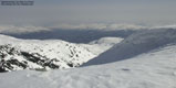
Volafjellet seen from Horn |
Volafjellet is located in the SE outskirts of Stølsheimen. Few will however acknowledge that Volafjellet belongs to Stølsheimen, but for these pages, I have found it practical to use Stølsheimen as the name for this large mountain area south of Sognefjorden and north of highway E16.
Volafjellet summit is a less distinct top on a plateau that consists of many smaller tops. The views are however excellent. Kvitanosi is easy to spot in the NW, while Lønahorgi can be seen in the east. In addition, a string of Sogn and Hordaland mountains dominates the horizon all views.
The mountain area is excellent for skiing and hiking. The climb up the mountain is gentle, and once up, a wide landscape lays before you. A trip that includes Lønahorgi is a way to make the trip long and extra rewarding.
Tvarafjellet is a slightly smaller, but separate mountain, east of Volafjellet. Seen from the north, it would be difficult to identify this mountain, but when seen from the south, one notice the dramatic cliffbands that are characteristic for this mountain. The two mountains are divied by the Helleskaret pass, also quite distinct, as it drops steep into Hellebotnen below.
Primary Factor
Volafjellet has a primary factor of 197m, towards the higher Lønahorgi (1410m). The saddle is somewhere along Vidvangane. Last 20m adjacent contours are 1140m, and the saddle is interpolated to 1130m. For instance, near point 1159, where the contours are quite close.
Tvarafjellet's primary factor towards the higher Volafjellet is 103m. The last 20m adjacent contours in Helleskaret are 1200m, and the saddle is interpolated to 1190m. Note that if the actual saddle height is 1194m or higher, this mountain will not be considered "ranked", as the primary factor will drop below 100m. Although the mountain is quite characteristic in respect to the cliffbands and the steep drop towards the south, the mountain can hardly be called prominent, when viewed from the higher Volafjellet. From the Volafjellet summit, looking towards Lønahorgi, Tvarafjellet can not be seen, as it is hidden by Volafjellet's 1311m point on the east side.
Note: Class ratings are in reference to YDS (Yosemite Decimal System).
|
Dyrvedalen - Volafjellet - Tvarafjellet (winter)
|
|
Access
From Bergen, follow E16 towards Voss. At Bulken (approx. 9Km before Voss), follow E16 for 2,8Km from the Bulken junction. Exit left towards Dyrvedalen. Follow the Dyrvedalen road uphill. On the paved section, go straight ahead in the first (immediate) junction. At the next junction, go right and follow Dyrvedalsvegen road upwards. The road now turns to a gravel road. 3,5Km from the highway, and just after a bridge, turn right onto a gravel road and follow this road 200m to a gate. The gate may be open, but this is a private road. Park by the gate, but don't block for tractors driving timber that is wider than the road itself.
The route
Volafjellet
Follow the gravel road upwards. After a long stretch SW, go right in the road junction and follow the road a long stretch NE. You will enter a "S" curve as the road starts to climb. Halfway up the long hill, exit left onto a side road. This road ends shortly after.
In summer, there should be a visible trail to the Mjølkeråni cabin. In winter, you have to find your way through the forest. Keep NW direction until you are out of the denser forest. You may spot Mjølkeråni up to your right. Find a good route westbound and get on the ridge by Storhaugen. Keep a NE route up to approx. 900m before adjusting the course to N towards Sledavarden. The climb NE and stay on the right hand side of the deep gully/valley to your left. Continue all the way to the Volafjellet plateau and turn NW at approx. 1280m and go to the summit. A broken cairn and the reminders of a trig. point denotes the summit.
Tvarafjellet
Go across the plateau, NE towards Gygrabruni, which is a distinct top with a steep south face. Find a good route down to Helleskaret with Gygrabruni to your left. Go down to the base of Tvarafjellet, and climb up the gentle slopes to the summit. Note that Tvarafjellet consists of two ridges. The 1293m summit is on the one to your left. This is difficult to see from below. Yet another broken trig. point denotes the summit.
Return the same way, but instead of climbing up next to Gygrabruni, find a route that will take you east of Volafjellet point 1311m. The maintain a SW course until you join your ascent route.
|
After a great hike to Håfjellet in Etne the day before, it was time to put the skis back on. The weather was still gordeous and it would be a crime not to go up to the mountains. I chose Volafjellet as the destination, as it looked to have some gentle south slopes, excellent for skiing. Near the top of Dyrvedalen, I rang a doorbell and asked for trail descriptions. After getting some good advice, I got in the car and drove up. I skipped at least 5 heartbeats when I noticed a cat through the mirror. While I was asking for instructions, a highly pregnant cat had jumped in the open window and taken the rear-window seat. I drove back to the house and got rid of the adventure-seeking animal. It wasn't quite obvious how to lift a pregnant cat, even if I've had two cats of my own. By the sound of the cat, it didn't seem like I found the optimal way. To my delight, they had made a new forest road that would give me a easy ride through most of the forest. I left the trailhead at 10:40AM, and limped up the forest round. The blisters that I developed in Scotland caused more pain than ever. I tried a triple band-aid solution, without any greater success. Thanks to good instructions from a guy I met at the trailhead, it was easy to find the trail towards Mjølkeråni. This end of the forest road was also the snowline, and I put the skis on. I was grateful that someone else had gone up here with skis earlier, and I had an easy trip through the dense forest. At Mjølkeråni, I didn't find the slopes up to Volafjellet as gentle as I had hoped for. But I followed the skitracks towards Storhaugen, hoping they would lead me to the mountain. They did, and soon I was on route towards the mountain. Skiing up the mountain was delightful. The sun was shining, soft snow everywhere (too soft, perhaps), blue sky, and no other humans in any direction. I arrived the Volafjellet summit 13:50PM and enjoyed the great view towards Kvitanosi. I left the summit 14:00PM and headed across Tvarafjellet. I skied down to Helleskaret pass with Gygrabrun on my left, then down a bit before I started the climb towards Tvarafjellet, which I reached 14:50PM. On top, I noticed three hikers coming towards Tvarafjellet, across Vidvangane. In this great white landscape with soft and rotten snow, they didn't quite match the picture. On my way back to Volafjellet, I watched them take on a mighty steep snowgully that would lead them to the plateau below Tvarafjellet. I was wondering what their destination was, because from this plateau, there seemed to be no easy route out. Skiing down the mountain was the big reward for all the hours of struggle. The rotten snow didn't invite to a fast descent, but it was nice nevertheless. And by now, I saw skiers here and there in the slopes. Perhaps this was where the cross-country skiers from Voss come. At least there were more cars at the trailhead when I arrived there at 17:10PM. The trip took 6,5 hours and included a total vertical ascent of approx. 1300m. Highly recommended!
|
Move cursor to read notes, and click on the images to see full version.
Some of the thumbnails may have been cropped to fit the format.
Pictures are presented in the order they were taken.


 Other hordaland mountains
Other Voss K. mountains
westcoastpeaks.com
Other hordaland mountains
Other Voss K. mountains
westcoastpeaks.com

