
European Mountains,
Bulgaria
Vihren, 2914m (Вихрен)
Hvoynati Vrah (Chvoinati peak), 2649m
| Maps : | GPS: bgmountains.org | ||||
| Primary factor : |
Vihren: 1784m Hvoynati Vrah: 50m |
||||
| Hiked : | July 2011 | ||||
| See also : |
| ||||
| See also : | Other European mountains on westcoastpeaks.com |

Vihren
(Click for larger image)
Introduction
Vihren is the 2nd highest peak in Bulgaria, and the highest peak in the Pirin mountain range. According to Wikipedia - Vihren is also the 3rd highest peak on the Balkan peninsula, after Musala and Olympus.
The mountain is easily accessible from above the town Bansko - the most popular ski-resort in the country. You'll reach Vihren summit in 3,3km and 950 vertical meters after you set out from the Vihren hut at 1970 meters elevation. This is a very popular mountain, and there are no airy or difficult sections.

Vihren
(Click for larger image)
Hvoynati Vrah is a satellite top that you can easily include on your route - either upon ascent or descent.

Hvoynati Vrah
(Click for larger image)
Primary factor:
Vihren (2914m, N41.76732 E23.39890) has - according to internet sources - a primary factor of 1784m.
Based on the GPS track log, I have set the following (rounded) primary factor for Hvoynati Vrah (2649m, N41.75627 E23.39996); 50m.

GPS profile
(Click for larger image)
Google map
Google's interactive map. You can zoom, pan and click on the markers.
|
|
|

Trail descriptions
| This disclaimer is regarding all of the literature and instructional guides posted on the westcoastpeaks.com website. These instructions are guidelines only, and should not be used in lieu of common sense or judgement when attempting any of the actions involved or instructed. Westcoastpeaks nor myself will not be liable nor will it indemnify any form of compensation to anyone who has injured, harmed or even killed themselves or others while following any of the instructions written within the website. It should be noted by any persons willing to undertake any of the instructions provided that mountains offer varying levels of risk, regardless of size or incline. Risks to be considered are as follows but not limited to: wild animals, weather, the terrain, bad judgement, inappropriate or insufficient equipment, improper training or experience and of course, bad luck... |
The route descriptions are valid per
July
2011.
|
Route 1: Vihren hut - Vihren (summer/autumn)
|
|

Access
(all distances are approx. distances)
The starting point for this route description is the Malyovitsa village. Use Google Maps to get the road description from Sofia Airport, Sofia, Bulgaria (if this is your starting point) to N41.75672 E23.41637 - the Vihren hut, southwest of the town of Bansko.
If you start from Bansko, follow the main road upwards, along the river Glazne. At 1700 meters, turn right in a fork (N41.78213 E23.44779). The road is signposted Vihren. Follow this road until it ends at the Vihren hut (N41.75672 E23.41637).
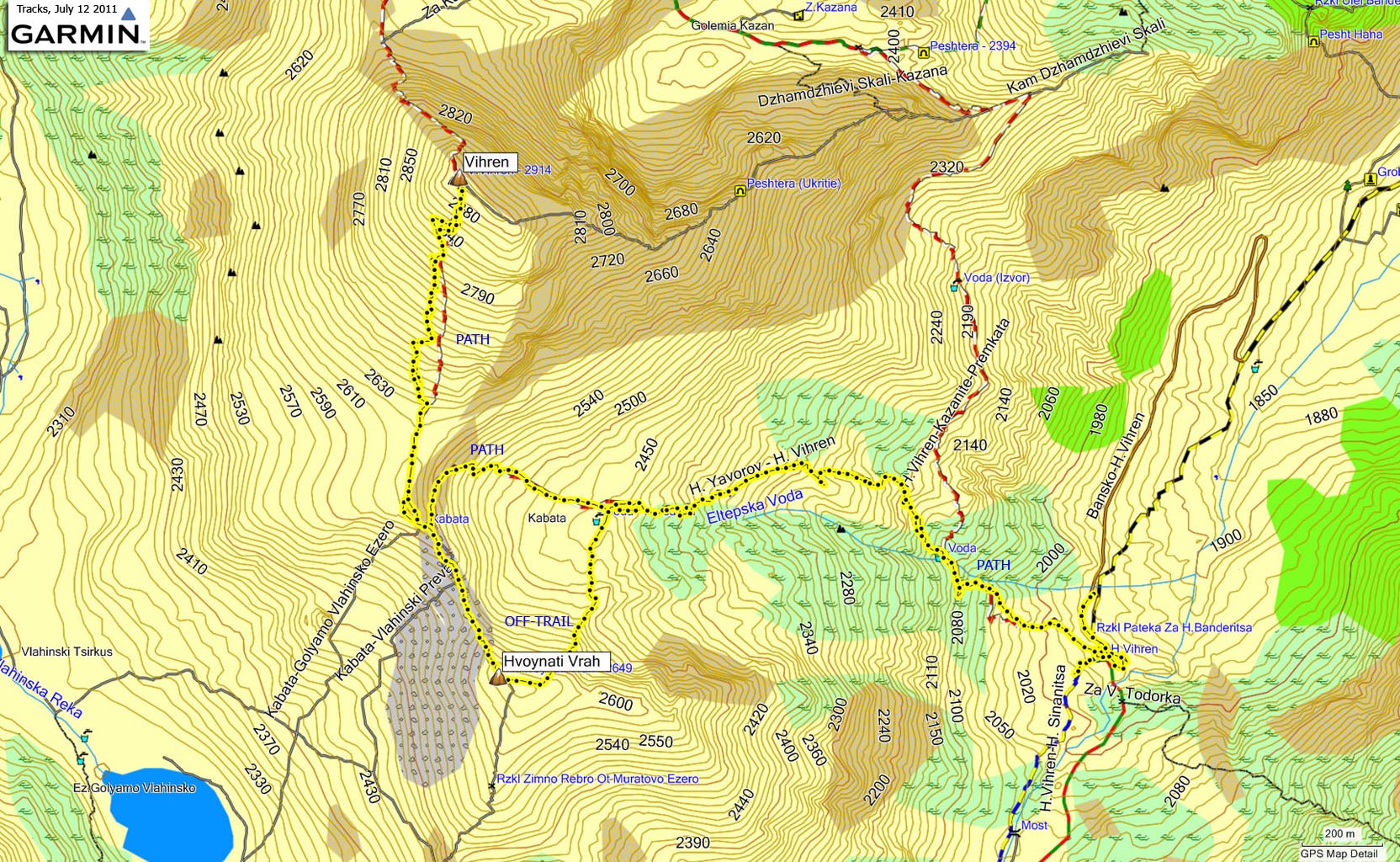
The route - To Vihren

The route, seen in Googlhe Earth
(Click for larger image)
Two main trails begin at the Vihren hut ; the Sinanitsa trail runs to the southwest, while the Vihren trail runs to the northwest. Make sure you see the Vihren signpost before heading out. The first part of the route runs through rocky terrain, but the trail is easy enough to follow. You'll catch "a break" in the basin below Vihren, but then the trail climbs steeply up to the ridge and the final 300 vertical meters to the summit.
The summit (N41.76732 E23.39890) is marked by an odd "cairn" and a broken concrete structure. If you have the time and energy, consider also visiting Kutelo (2900m) - 1,4km to the northwest.
Upon descent, consider visiting Hvoynati Vrah (2649m) - only a 0,4km walk from the point where you ascended the ridge. From the summit (N41.75627 E23.39996), it is fairly easy to descend Hvoynati's northeast ridge (off-trail) and join your ascent route down in the basin.

Early on the trail
(Click for larger image)
Pictures and Trip reports:
- Vihren, July 12 2011
 westcoastpeaks.com
Other European mountains
Other Norwegian mountains
westcoastpeaks.com
Other European mountains
Other Norwegian mountains