
|


Tustnastabbene" is a common name for the high mountain tops on Tustna and Stabblandet islands, formerly Tustna kommune before the union with Aure. The names of the tops vary, depending on your source of information. The names used on this page is based on maps and information from local people.
Innerbergsalen (908m) is the highest of the mountain tops. It is also the highest mountain in Aure kommune, and the highest island top in southern Norway. The mountain can be reached on several routes; from Innerberg via the southwest ridge, from Fjelnesdalen via the southeast ridge, via Stabben (steep route!) or Grova from the north, and it is also possible to walk up directly from the Innerbergsalen - Storøra saddle. This is a steep route, and caution is required in the lower part. There are of course other possibilities, but these seem to be the obvious routes.
Storøra (905m) is the 2nd highest mountain, in Aure, on Stabblandet and among the southern Norway island tops. The easiest routes run via Runden (609m), either you come up Solemsdalen (north), of Fjelnesdalen (south), and from Ørbogen via the north ridge.

Innerbergsalen
Skarven (899m) is the highest top on Tustna island, the 3rd highest top in Aure kommune and the 3rd highest island top in southern Norway. Skarven is normally reached from Gullsteinsdalen, either via the north ridge or from the Jørenvågsalen - Skarven saddle, or from Ersviksetra, via the south ridge.
Jørenvågsalen (857m) is the 2nd highest top on Tustna island, the 4th highest top in Aure kommune, and (probably) the 6th highest island top in southern Norway. Hornelen (889m, Bremangerlandet) and Høgefjellet (868m, Osterøy) preceeds Jørenvågsalen on the island list. Jørenvågsalen is also known as Jurtinden. The normal routes run up Gullsteinsdalen and via the Jørevågsalen - Skarven saddle, or via Knubben - on the north side of the mountain plateau.

Skarven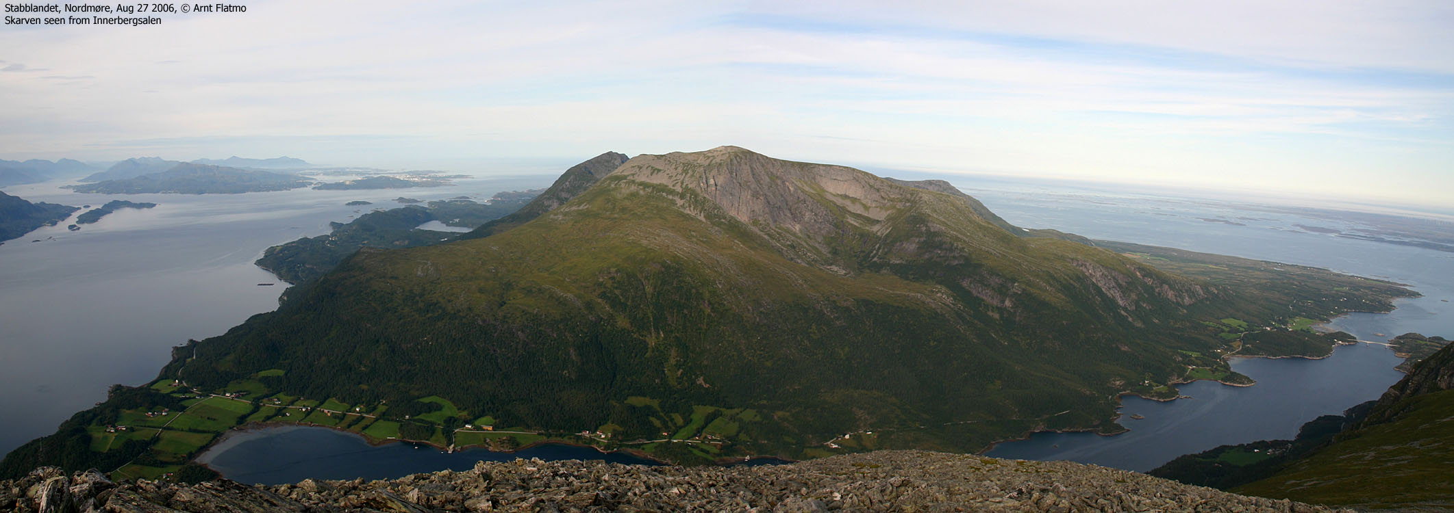
|
"SEVEN PEAKS NIGHTMARE" A couple of enthusiasts from Tingvoll Tindeklubb has named this hike that runs across all "Tustnastabbene", probably based on how it feels upon completion. The hike has been done a couple of times. They start out at Leira, hike up to Knubben (peak #1) via Vettalivatnet before continuing south to Jørenvågsalen (peak #2). They continue eastbound on the normal route towards Skarven (peak #3) before they descend the north ridge (via Dyrkollgrova) and down to the road junction before the bridge across Soleimsundet. On the other side, they take a short-cut towards Soleim and hike a steep (and partly exposed) route up to Stabben (peak #4). They scramble southbound in exposed terrain before they get on more gentle terrain southbound towards Innerbergsalen (peak #5). Rather than hiking directly eastbound from Innerbergsalen, they "fight" their way down the forest, a bit further southeast, before traversing the forest to the Innerbergsalen - Storøra saddle. The remaining route up to Storøra (peak #6) runs on far easier terrain. Finally, Litløra (peak #7) is reached by descending Storøra to the southeast, followed by a traverse to the Storøra - Litløra saddle. The hike involves approx. 3400 vertical meters and takes somewhere between 20 and 24 hours. Good luck! |
Innerbergsalen (Norge 1:50,000: 908m, Økonomisk Kartverk: 907,91m, UTM 32 V 460714 7004920) has a primary factor of 908m, being the high point on Stabblandet island.
Skarven (Norge 1:50,000: 896m, Økonomisk Kartverk: 899m, UTM 32 V 456326 7005638) has a primary factor of 899m, being the high point on Tustna island.
Storøra (Norge 1:50,000: 905m, Økonomisk Kartverk: highest contour: 905m, UTM 32 V 463055 7005799) has a primary factor of 664m, towards the higher parent Innerbergsalen (908m). The defining saddle (approx. UTM 32 V 461677 7004753) is found between the two tops. Ref. Økonomisk Kartverk, the saddle is defined by a fixed point - 241m.
Jørenvågsalen (Norge 1:50,000: 857m, Økonomisk Kartverk: 857,07m, UTM 32 V 454641 7005005) has a primary factor of 367m, towards the higher parent Skarven (899m). The defining saddle (approx. UTM 32 V 455463 7004998) is found between the two tops. Ref. Økonomisk Kartverk, the saddle is defined by a fixed point - 489m5m ~ 490m.
Personal GPS measurement averaged the elevations to: 858m on Jørenvågsalen, 893m on Skarven, 915m on Innerbergsalen and 907m on Storøra. All measurements were done on the ground. On Innerbergsalen, two GPS devices reported 914-915m on the ground, and one reported 918m on top of the summit cairn (about 3m high). It is reasonable to assume that Innerbergsalen is slightly higher than 908m, and that the Økonomisk Kartverk height for Skarven (899m) is too high.


Notes: Class ratings are in reference to YDS. Click here for more information.
The trails described below are not necessarily the *easiest* trails to this mountain.
|
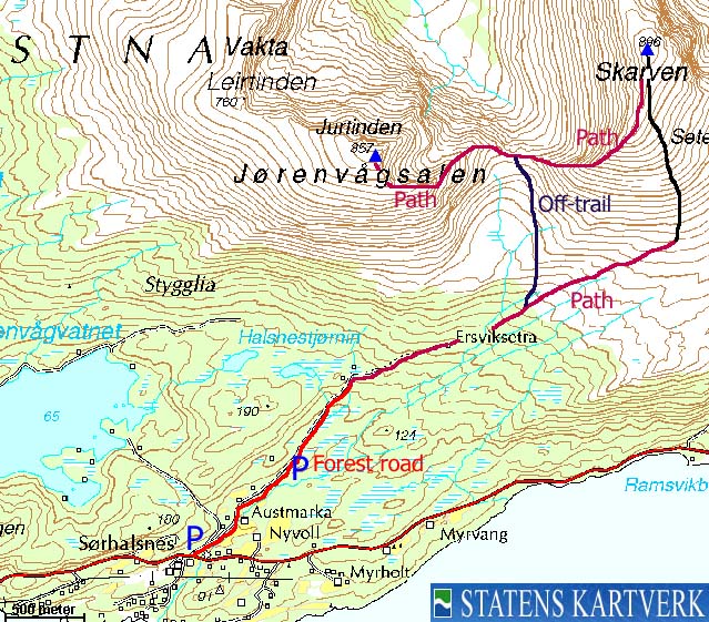
Halsnes - Skarven - Jørenvågsalen (summer/autumn)
|
|
Access
From Kristiansund, follow highway RV680 eastbound and signs to "Smøla/Aure/Tustna". Take the Seivika - Tømmervåg ferry. From Tømmervåg, drive 700m and turn right towards "Indresæter". Drive 7,3Km and turn left onto an unsigned gravel road. For low-clearance cars, it is possible to drive approx. 700m on a road that turns rough.
The route
Skarven
Follow the rough road towards the northeast. The road turns into a forest road and runs to a cabin at 140m elevation. Just before this cabin, turn right when you see the "Skarven" trailsign. Follow a vague path northeast into the forest. You should be able to follow this path all the way to 400m elevation - where you are above the tree-line. From this point, head off-trail up to Skarven summit (proper cairn), crossing boulderfields along the way.
Jørenvåsalen
Descend Skarven's south ridge (fun route!) down to the Skarven - Jørenvågsalen saddle. Follow a visible path up Jørenvågsalen's southeast ridge and up to the summit (proper cairn). The southeast ridge has one point which can said to be partly exposed. For the majority of hikers, this point should offer no problems, whatsoever. Those with absolutely no tolerance for heights may feel uncomfortable here.
Descend the same route down to the saddle, and follow a marked trail southbound. If you loose track of this trail, then head southbound until you cross your ascent route.


|
Innerberg - Innerbergsalen - Storøra (summer/autumn)
|
|
Access
From Kristiansund, follow highway RV680 eastbound and signs to "Smøla/Aure/Tustna". Take the Seivika - Tømmervåg ferry. From Tømmervåg, follow highway RV680 approx. 17KM and turn left towards "Aure/Smøla". Drive 2,5Km and turn right towards "Soleim". Drive 1,8Km and turn left. The road turns into a gravel road after a while. Drive 7,2 to road end at Innerberg. Park here, or consider your cars' future. A low-clearance vehicle CAN drive the remaining 2,6Km towards Fjellnesdalen. At 2,6Km, you can find a "pocket" to park on the left-hand side, 250m before the valley path (and before the road descends towards the Fjellnesdalen houses, and before an open field on the right-hand side. Do note that this is a road only suited for high-clearance vehicles (4WD trucks).
The route
Innerbergsalen
Just as the 4WD road descends towards the Fjellnesdalen houses, turn left onto a forest path marked by a stick. Follow this path 150m through the forest. First through forest, then as you enter open space (not on the sides, but on the path), turn left and follow a vague forest path that runs towards a distinct forest gully. The path follows the gully upwards, and switchbacks along the way. At approx. 340m, you are above the tree-line and have Innerbergsalen in clear view ahead of you. Proceed off-trail up to the summit (proper cairn), crossing a boulder field along the way.
Storøra
Descend back to the path from Fjellnesdalen and follow it up towards the Innerbergsalen - Storøra saddle. The path becomes more visible on the east side of the valley stream. From the saddle, you can follow a path all the way up to Runden, which you might want to pass on the south side. From the Runden - Storøra saddle, proceed off-trail up to Storøra summit (proper cairn), passing a boulderfield along the way.


 westcoastpeaks.com
Other Møre & Romsdal mountains
Other Norwegian mountains
westcoastpeaks.com
Other Møre & Romsdal mountains
Other Norwegian mountains


