
Norwegian Mountains, Møre og Romsdal
Syvdsalpane/Breiteigsfjella
Across "Syvdsalpane", July 24 2009
To the main Sandegga/Trollkoppehornet page (maps, route descriptions, other trip reports, etc.)

Syvdsalpane/Breiteigsfjella
(Click for larger image)
This was a hike I had looked forward to for quite some time. These peaks look awesome when seen from the Syvdsfjorden side. My fellow hiker on this trip was Edvin Østrem. Edvin lives much further south in Norway, but spends his summers in Vanylven. We had been in contact via email for a while, planning to do the Syvdsalpane hike together.
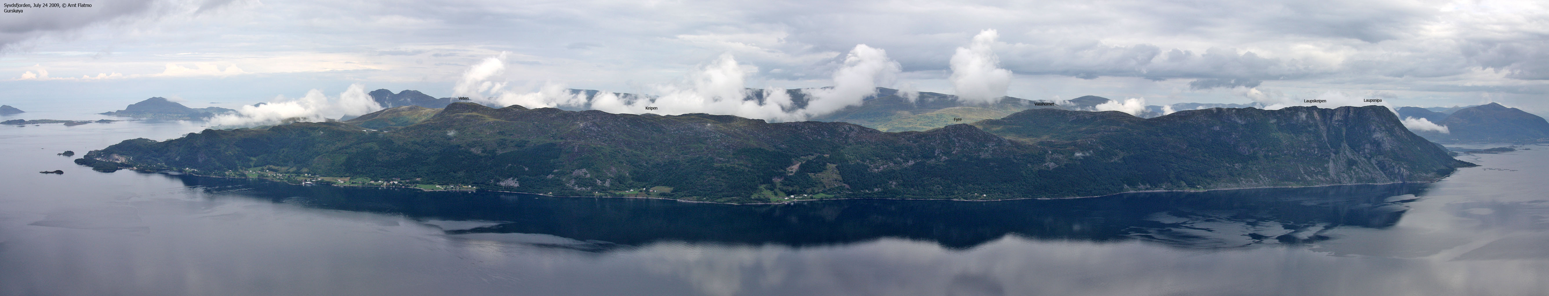
As explained on the information page, Syvdsalpane / Breteigsfjella are common names for the characteristic peaks that rise out of Syvdsfjorden. The actual mountain is called Sandegga or Skoranipane on maps. Trollkoppehornet (974m) is the highest point on this massif.
The weather on this Friday morning was not good. It was pouring down when I was waiting for the ferry at Årvika, and Sandegga was so grey and cloudy that it could make one cry. This kind of weather would not do justice to this mountain! On my way across the fjord, it stopped raining, and thick fog was now eating up the mountain. But by the time I got to Syvden, it had cleared and it seemed to be a splendid day. And all this happened within 30 minutes..

Dramatic weather shift. For the better...
![]()
(Click for larger image)
I teamed up with Edvin in Syvden. After saying hello (this was the first time we met) we drove to Skor and left his car there, before continuing to Syvdsneset. Both of us were under the impression that the trail would be well-worn and marked. At least the Vanylchattedven Turkart map led us to make this assumption. But no trail could be seen, so we just had to start walking and see what we would come across.
It was obvious that we should stay left of the first section of the ridge, and after a little while, we found a vague path that we stuck to. Once on the ridge proper, the path was slightly more distinct. Not that it was all that important, as there was no forest to fight. And the ridge itself was - though steep in places - easy to follow.
We took it nice and easy up the ridge. It was turning into a very hot day, and the drifting fog only added value to the scenery which became more and more spectacular the higher we got. I took close to 100 pictures before we even reached Haukelandsnipa - the first of the Syvdsalpane tops. Edvin was excellent company, and we talked as if we had already known each other for some time...

VERY nice view
(Click for larger image)
We had left Syvdsneset 10:10am and arrived on Haukelandsnipa (743m) 12:15pm. It was time for lunch and to enjoy the views. We talked about the route ahead, then agreed on that it should be across the highest tops. We would still see a lot of the Syvdsfjorden side on our way to Fossanipa, and it was only natural to visit the highest point also. The weather was still fairly good, but a rain shower in the distance might just come our way...
Back on the path, we stopped by Labergsheia, Keipen and Fossenipa - all fantastic viewpoints. The hike was just as good as we had hoped it would get. And fun too...

Marshall arts..
(Click for larger image)
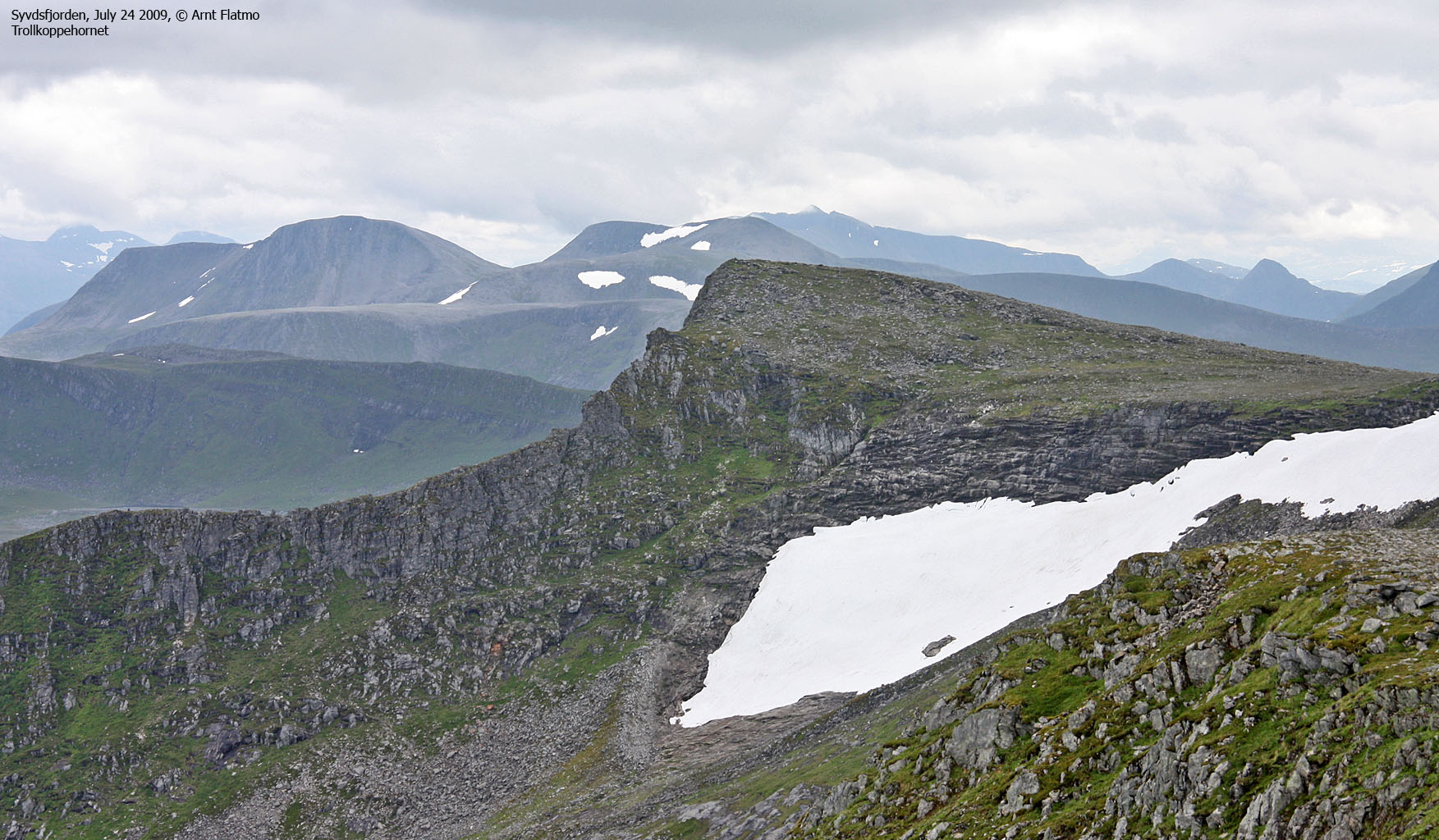
It was certainly tempting to continue along the edge, but we had decided to go for the ridge and we stuck to this plan. It is very likely that I soon will revisit this area - being very curious about the terrain near Høystakken. It took us 20 minutes from Fossanipa up to Sandegga 970m (1:40pm) The mountainside towards Rovde was steep, but not quite as fascinating as the Syvdsfjorden side.
Trollkoppehornet (2:18pm) was a 20-minute walk from Sandegga. It was raining lightly by now, but that was OK. We would soon be on our way down anyway. The view would have been quite extensive from up here, had it not been for the rain clouds. No complaints, though. It was very good to (finally) be up here.

Trollkoppehornet and I
(Click for larger image)
It was time to head back down, west in the direction of Fossane. We found a vague track along the ridge south of the river - which was just a creek at this time of the year. Thirsty as we were, it was nice to come across running water again. The sun was now shining, and this was just a nice spot to be in. Edvin was still smiling, like he had done throughout the hike. He'd been wanting to do this hike for quite some time, too.

Edvin in Fossane
(Click for larger image)
We lost the vague track as we arrived in the valley below, then aimed for a cabin further down on the meadows - a natural place to look for a path. We met a group of people at this cabin, and we chatted for a while. They pointed out the path for us, which was easy to follow until we were almost down. After a short-cut through someone's backyard, we were back at Edvin's car - 4:07pm, approx. 6 hours after heading out. Edvin drove me back to Syvdsneset where we parted. And hopefully - there will be a '10 summer hike with him.


")


