
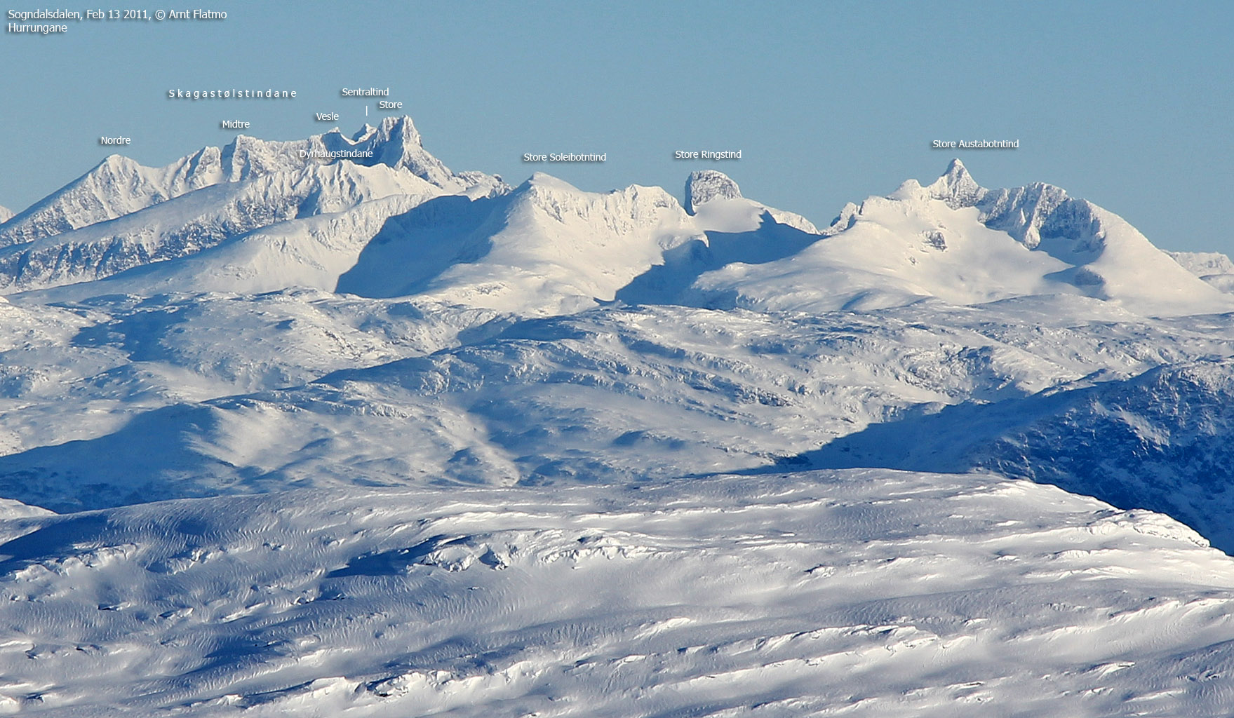
Norwegian Mountains, Sogn og Fjordane
Torstadnakken on skis, Feb 13 2011
To the main Torstadnakken page (maps, route descriptions, other trip reports, etc.)

The winter route to Torstadnakken
(Click for larger image)
The day after finally reaching the top of Lusaskard, Anne and I decided to visit Torstadnakken. Anne had already been there a couple of times, but I had been (intensely) wanting to visit this mountain ever since I began commuting to Sogndal. This Sunday was a beautiful, but cold day. The temperature was -13 deg. C. in Sogndal, and we expected it to be only slightly colder on the mountain. But when we crossed the Hodlekvebrui bridge, the temperature sunk to -23. And the temperature kept sinking on our way toward Svedal; -24, -25, -26, -27, -28 and ...

Omigod...
(Click for larger image)
Second to my worry about taking on a long ski-trip with this temperature, was the thought of a car that wouldn't start upon return. But when we reached the Svedal farm - at 440 meters - only 40 vertical meters above the road and bathing in sunshine, the temperature was -13. I figured that the car gauge must have gone crazy, but the woman who granted us parking told us that it was more than likely that it was twice as cold down by the lake.
The trip was now on, and the good news was that someone had already broken trail. We headed out 10:40am and had an easy ride up to Grøssete (840m) that we reached 1 hour later. No longer in shelter by forests and valleys, we had to put more clothes on. We were on our way up a windy mountain!

Towards Grøssete
(Click for larger image)
We still had a long way to go, and it was gradually getting colder. But we were well dressed and prepared and could really enjoy the ski-trip. The views were getting better and better, and I couldn't wait to get to the top.
We passed point 1328m at 1:15pm, descended into a pass and began the final climb to the summit. We reached the first cairn 2:20pm (3h:50m after heading out), and it was time to take a look around. Anne had told me that the high point was somewhere between the two cairns, and it seemed clear that the terrain was slightly higher to our right (east).

Arriving at the first cairn
(Click for larger image)
After a short stop, we moved on to the second cairn. The summit plateau was large enough to give me the feeling of being on top of a glacier - where you have to move around until you find the point where the horizon seems level in all directions.
I have no idea of what the effective temperature was, but even if we were well protected from the wind, it was cold enough to be very serious in case of an accident. This thin line between pleasure and drama was a bit surreal, and I kept thinking about it the whole time we were up there. I'm sure the thought crossed Anne's mind too.

A cold and windy mountain
(Click for larger image)
We proceeded to the second cairn and arrived there 2:30pm. It seemed clear that Anne was correct, in that the high point was a bit further to the south. From the cairn, we couldn't see the southern horizon, which is a good indication of not being on the highest point...
After a round of pictures, we continued up to the high point and celebrated the high point of the trip at 2:35pm. The views were astonishing, but I would better have to enjoy them in front of the computer later on. It was getting late in the day and we wanted to get down before dark.
 cairn")
The second (north) cairn
(Click for larger image)
We (more or less) followed our tracks (the little we saw of them) on the way down. The skiing conditions for descent were not good (wind-packed snow), and we took it nice and easy. Some Sastrugis were tall and thick enough to cause a sudden halt (and a succeeding dive), and we were not going to have accidents!

Taking it easy...
(Click for larger image)
The snow got far better as we got closer to Grøssete. After passing the cabins, skiing was now quite enjoyable, and tracks everywhere revealed that we were not the only ones enjoying the descent from Grøssete. We returned to Svedal 4:07pm - close to 5,5 hours after leaving.
It was a fantastic weekend with two new peaks and two excellent ski-trips in gorgeous weather. It's amazing how quickly weeks and weeks of bad weather is forgotten after two days like these...

Approaching Grøssete, on the way down
(Click for larger image)


