
|


Storskjerdingen and Tverrfjellet are neighbouring tops, forming a side-valley to Nakkedalen, known as Botnen. Both tops are easily accessed from Nakkedalen.
These tops are minor tops on the Blåskjerdingen massif, and Nakkedalen can also be a starting point for accessing Skjerdingen, via Lake Skjerdingsvatnet. In a region where you often find roads on both sides of a mountain, this "back-country" is quite nice and deserves to be visited.
The Tverrfjellet views are quite good, stretching well into Trollheimen.
Storskjerdingen (Norge 1:50,000: 617m, Økonomisk Kartverk 1:15,000: 615,5m ~ 616m, UTM 32 V 386431 6942353) has a primary factor of 93m towards the higher parent mountain Litleskjerdingen (678m). The defining saddle (approx. UTM 32 V 385821 6941757) is found between the two tops. Ref. Økonomisk Kartverk (5m contours), the saddle is within the range 520-525m, interpolated to 523m.
Personal GPS measurement averaged the elevation to 620m, over a 5-minute period. The GPS was located on the ground. The GPS accuracy was reported to be 5m.
Tverrfjellet (Norge 1:50,000: 664, Økonomisk Kartverk 1:15,000: 663,61, 32 V 386282 6943498) has a primary factor of 91m towards the higher parent mountain Grøtfjellet (735m). The defining saddle (approx. UTM 32 V 386292 6944054) is found between the two tops. Ref. Økonomisk Kartverk (5m contours), the saddle is within the range 570-575m, interpolated to 573m.
Personal GPS measurement averaged the elevation to 668m, over a 5-minute period. The GPS was located on the cairn, approx. 1,5m high.
Notes: Class ratings are in reference to YDS. Click here for more information.
The trails described below are not necessarily the *easiest* trails to this mountain.
|
Nakkedalen - Storskjerdingen (summer/autumn)
|
|
Access
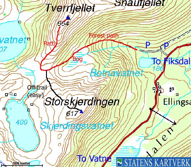
From Ålesund, follow highway E39 towards Åndalsnes. From the E136/E39/Olsvika roundabout near Breivka, follow E39 13,3Km. Turn left onto highway RV661 (Skodje/Brattvåg/Vatne). Pay toll at an unmanned toll booth (coins + credit cards) 1,5Km later. 8,7Km after you left E39, you reach the 659 (Brattvåg) /661 (Vatne) junction at Eidet. Turn right here. Pass the place Vatne and stay right in the road junction there, drive up Vatnedalen, across Reset and descend into Nakkedalen. 14,5Km from Eidet (and 3,5Km from the top of Vatnedalen), turn left onto a gravel road. You may drive this road approx. 300m and find parking on a turn-out on the right-hand side of the road. Alternatively, park near a forest road junction a bit earlier.
The route
Follow the forest road to its end, and follow a nice forest path up to 400m elevation, where the ground may get boggy. Proceed westbound in the outskirsts of a meadow and gradually climb up to the Tverrfjellet - Storskjerdingen saddle at 500m elevation. Leave the path and proceed off-trail, on grass, southeast up to the top of Storskjerdingen, which is marked by a small cairn.
|
Nakkedalen - Tverrfjellet (summer/autumn)
|
|
Access
See "Access" for the Storskjerdingen route.
The route
Follow the forest road to its end, and follow a nice forest path up to 400m elevation, where the ground may get boggy. Proceed westbound in the outskirsts of a meadow and gradually climb up to the Tverrfjellet - Storskjerdingen saddle at 500m elevation. Walk until you see the path that runs up Tverrfjellet's south ridge. Follow this path to the summit cairn.


No Javascript:
 westcoastpeaks.com
Other Møre & Romsdal mountains
Other Norwegian mountains
westcoastpeaks.com
Other Møre & Romsdal mountains
Other Norwegian mountains

