
|

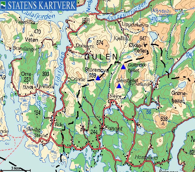
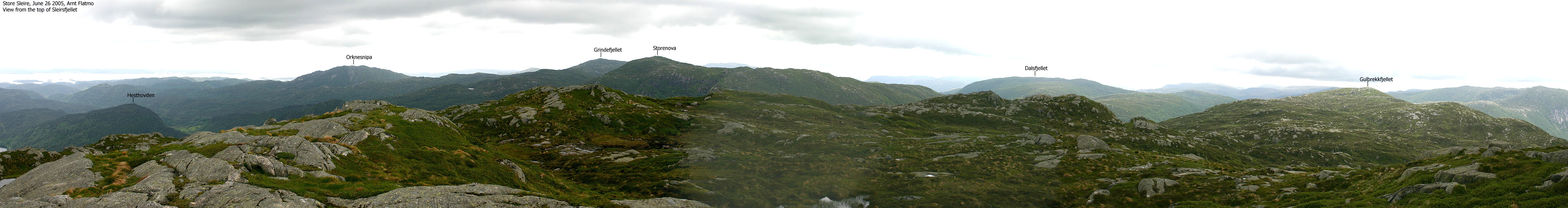
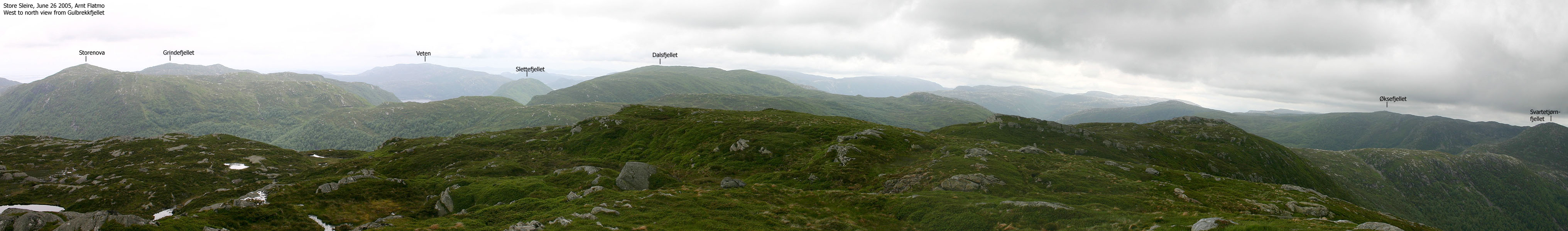
Gulbrekkfjellet and Storenova (Sleirsfjellet is not considered an independent mountain in this context) are located on Gulenhalvøya (Gulen peninsula) and are part of a mountain range that separates Sogn and Fjordane and Hordaland fylker (counties).
This web-page describes a round trip from Sleire that includes both mountains. Alternatives are mentioned along the way. If you want to hike Storenova only, Sleire is the best place to start. An alternative trailhead is Vyrkesdal in Dalsøyra. If you want to hike Gulbrekkfjellet only, the best starting place is Kjellbju S of Austgulfjorden, but the Sleire trailhead will offer more alternatives.
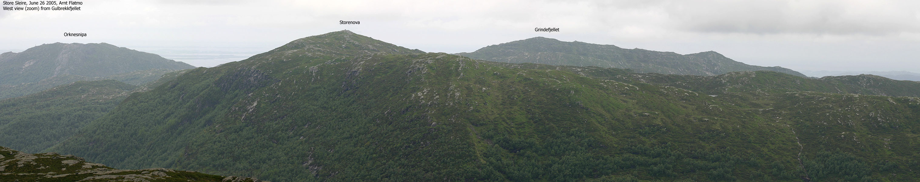
Storenova (M711: 559m, Ø.K: 558,67m) has a primary factor of 146m towards the higher Dalsfjellet (574m) The saddle is found in Austdalsskaret (Ø.K.) between the tops. Ref. Økonomisk Kartverk (5m contours), you cross the 415m contours on the high route, but not 410m. The saddle height has been interpolated to 413m.
Gulbrekkfjellet (M711: 566m, Ø.K: Highest contour is 565m) has a primary factor of 108m towards the higher Svartetjørnfjellet (637m). The saddle is found between the two tops, near Gulateigen. Ref. Økonomisk Kartverk (5m contours), you cross the 460m contours on the high route, but not 455m. The saddle height has been interpolated to 458m.
Sleirsfjellet (M711: 549m, Ø.K: 548,72m) has a primary factor of 51m towards the higher Gulbrekkfjellet (559m) The saddle is found on the plateau between the two tops. Ref. Økonomisk Kartverk (5m contours), you cross the 500m contours on the high route, but not 495m. The saddle height has been interpolated to 498m.
Notes: Class ratings are in reference to YDS. Click here for more information.
The trails described below are not necessarily the *easiest* trails to this mountain.
|
Sleire - Sleirsfjellet - Gulbrekkfjellet - Storenova round trip (summer/autumn)
|
|
From Bergen, you have two main alternatives;
a) w/ferry (Leirvåg - Sløvåg)
From Bergen, follow highway E39 northbound. After the Nordhordlandsbrua bridge,
pay (NOK 45,- for passenger cars per May 2005) at the Toll station. Drive 2,4Km
and turn left onto highway RV57 (Leirvåg). Follow RV57 36,6Km, then turn
right right towards "Leirvåg". The ferry to Sløvåg is 1,4Km
from this exit. Note that the ferry sometimes stop by Skipavik, west of Sløvåg.
Per July 2005, the ferry schedule was published on
ruteinfo.net.
From Sløvåg, continue 3,9Km. Turn right onto RV57 towards Duesund. Follow this road 6,2Km and turn right towards Sleire. Follow this road 6,2Km to Sleire and locate a gravel road that runs up to your left. Find parking nearby.
Another ferry alternative is Masfjordnes - Duesund. A scenic, but not the fastest or shortest route.
b) Via Kringla:
From Bergen, follow highway E39 northbound. After the Nordhordlandsbrua bridge,
pay (NOK 45,- for passenger cars per May 2005) at the Toll station. Drive 66,6Km
and at the Kringla junction, turn left towards Solheim/Duesund and drive down to -
and along the beautiful Masfjorden until you reach the Duesund junction.
Turn right and continue approx. 3,6 to another junction. Turn right here. This road
goes towards Brekke. Follow this road approx. 4,5Km to the Sleire junction. Turn left
and drive the remaining 3,1Km to Store Sleire. The gravel road mentioned above is up
to your right.
Another alternative is to drive along Haugsværfjorden via Solheim.
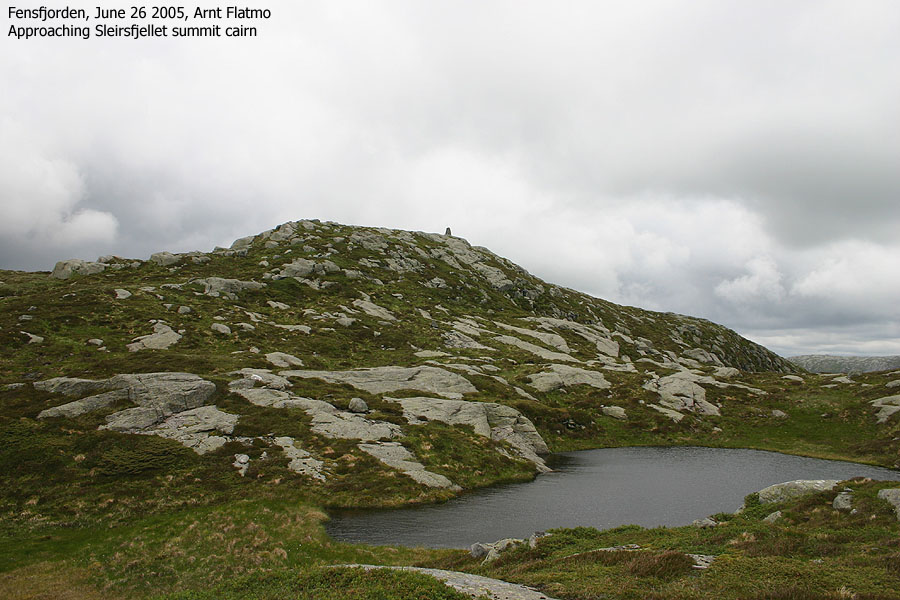
Follow the gravel road upwards and pass a gate early on. The road turns into a trail heading towards Lake Markhusdalsvatnet. Leave this road after 500m and follow (off-trail) a ridge up to your left that takes you all the way to the Sleirsfjellet summit cairn. This is easy terrain to follow. Hardly any bush.
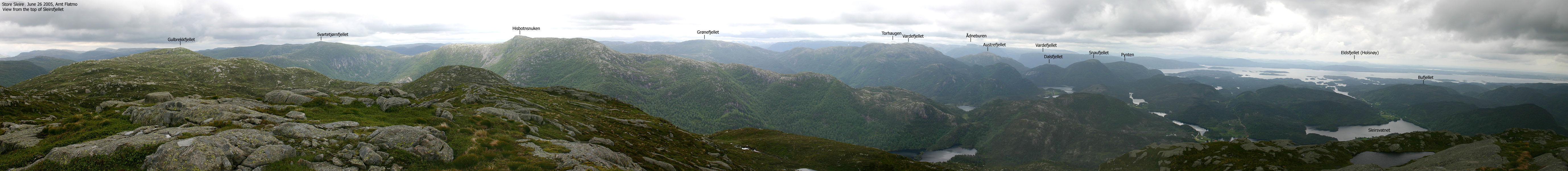
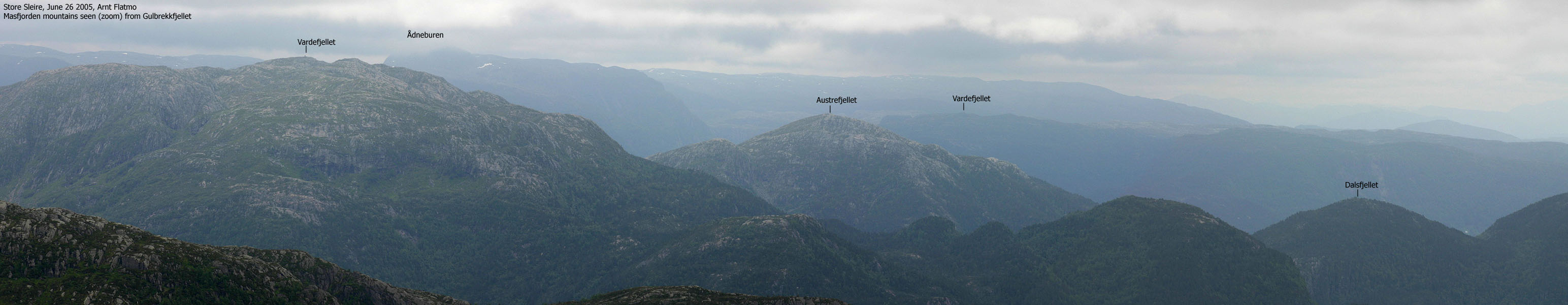
Proceed northbound towards Gulbrekkfjellet. Stay left on the plateau in the beginning. Gulbrekkfjellet has no proper summit cairn, but is easy to identify, being the only top.
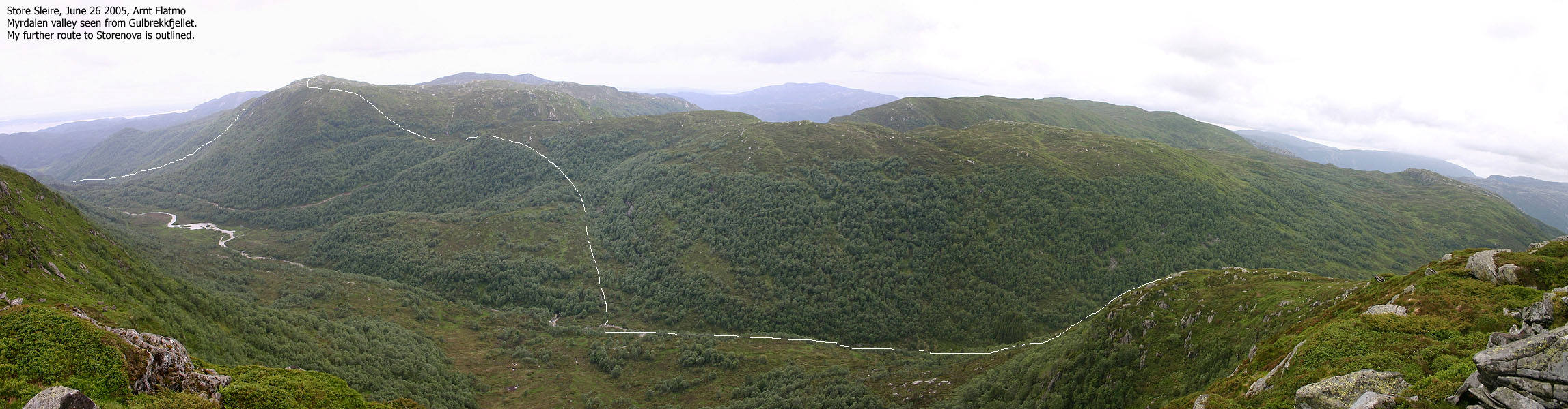
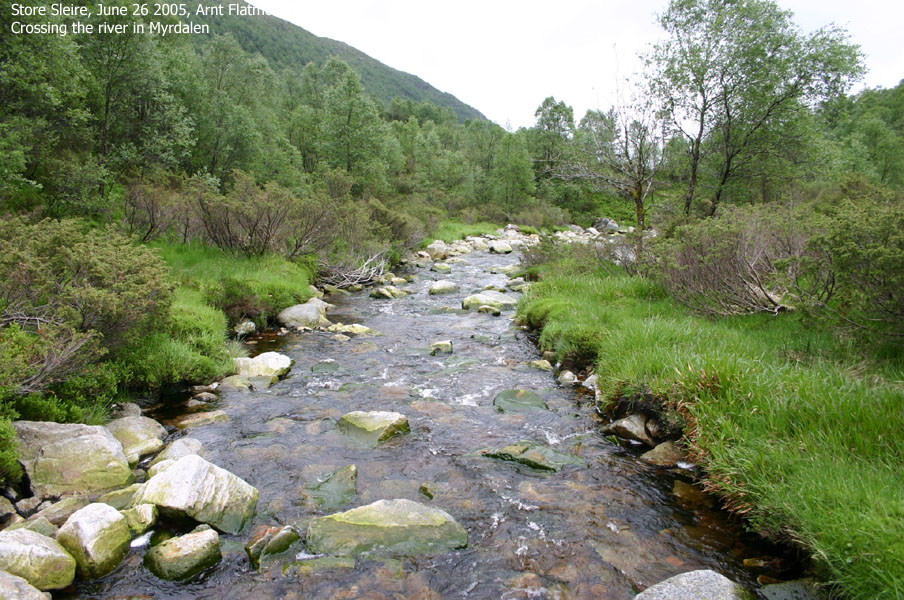
Proceed northbound 400m and descend northwest down a ridge that takes you down to Myrdalen valley. During this descent, you will have to descend ledges (nothing airy) and fight bush. Follow the Myrdalen path along the river for a little while before you cross the river and start ascending towards Storenova. If you are unable to cross the river in a safe manner, there is a bridge near Dalen further south. (If you don't want to include Storenova on your hike, just follow the Myrdalen path down to the forest road leading to Sleire)
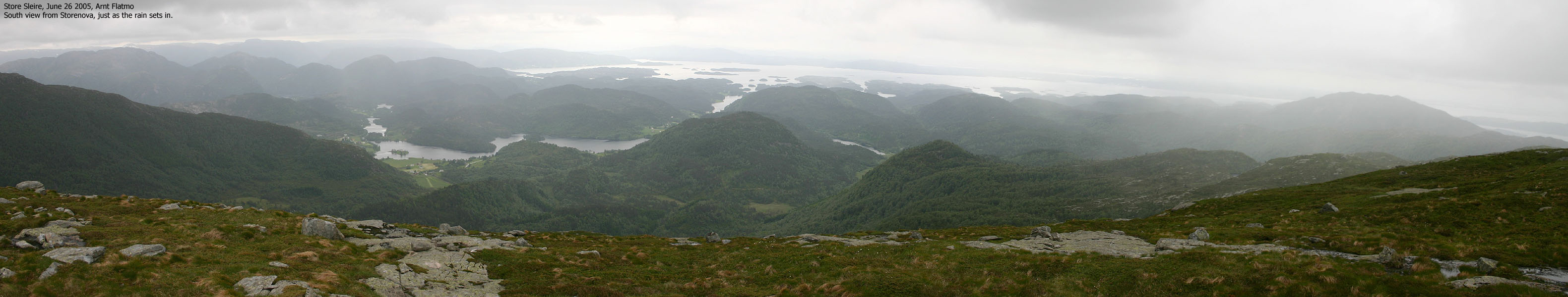
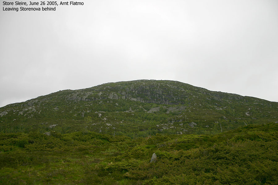
Follow Storenova's northeast ridge up to the summit cairn. Descend west down to the Grindefjellet - Storenova pass and follow the stream down in the southeast direction. At approx. 300m elevation, you reach a tractor road (turning into a forest road further down). Follow this road back to Sleire. There are a few junctions, but if you have taken a look at the map, you should have no problems following the main forest road.
|
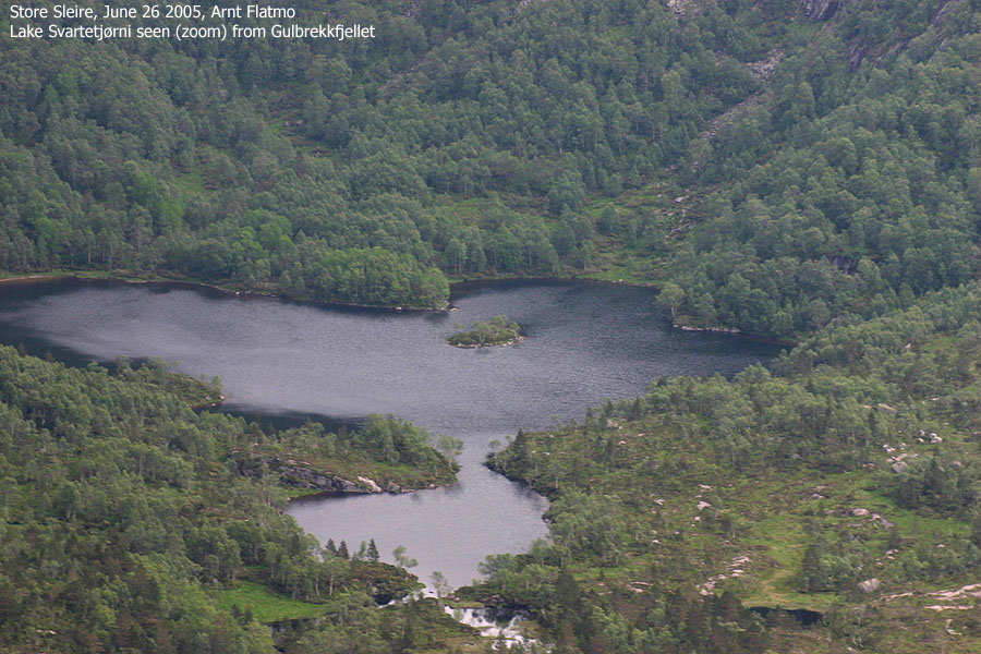
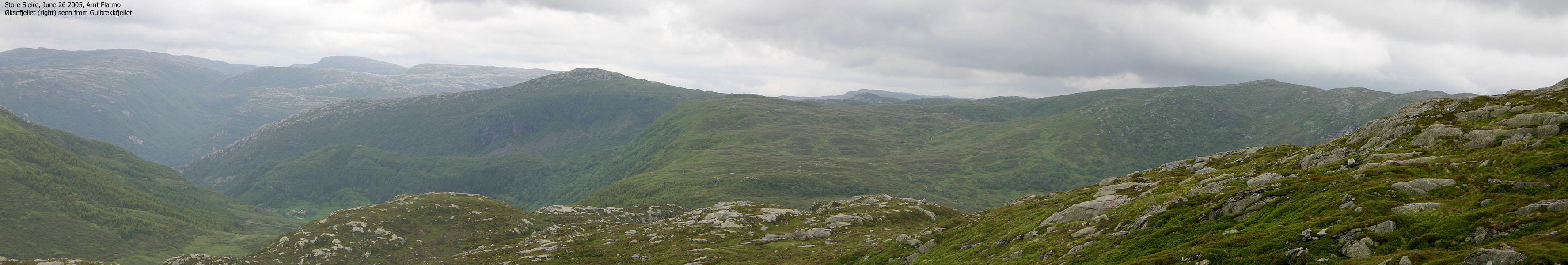
Trip report May 26 2005A mix of a bad weather forecast and tired legs after a tough hike in the Rosendal mountains the day before made me settle for something easier this Sunday. But as I had a dog-free week-end, I felt I should take advantage of the situation. My choice fell on the Gulbrekkfjellet - Storenova round trip, allowing me to tick off two more Hordaland mountains from my list. The decision came late. I was all ready to go - somewhere - and checked the Leirvåg - Sløvåg ferry schedule on the internet. If I left NOW, I would just make the 11:15AM ferry. I noticed that this ferry didn't run on Sundays, but this was not applicable. It was Saturday, and I was in a hurry to reach the ferry. Just before reaching Mongstad and the Leirvåg exit, it suddenly dawned on me that it was indeed Sunday, and it was more than one hour to the next ferry. Four-letter English words flew around and I wondered how I should kill one hour up here in the coastal district. It then came to mind that upon my visit to Litlåsfjellet back in Apr 2000 - the highest point in Austrheim kommune - I probably didn't visit the high point. With one hour to the next ferry, I made sure that the high point was visited once and for all. A while later, I arrived Sleira and talked to a local. I was granted permission to park on the gravel road that headed in the direction of Lake Markhusdalsvatnet. I left the car 13:20PM and reached the top of Sleirsfjellet 14:05PM. After a round of pictures, I realized that the pictures wouldn't be very good. The weather was "gloomy" and I wouldn't be surprised if it started to rain any minute now. I moved on towards Gulbrekkfjellet. By 14:40PM, I had collected Gulbrekkfjellet. I looked towards Dalsfjellet and Øksefjellet - mountains I had visited 5 years earlier. Back then, I had no illusion that I would be collecting Hordaland mountains and thought that I had visited Gulen mountains for the last time. But here I was, looking back at familiar mountains in all directions. I descended down to Myrdalen valley and encountered the evil bush that some of us associate with the Gulen mountains. I crossed the river and headed up to Storenova which I reached 16:30PM, just before the rain sat in. My feet were getting tired now, and I looked forwards getting back to Sleire. On my way up Sleirsfjellet, I could have sworn I saw a forest road down from the Grindefjellet - Storenova pass. But from my position in the pass, no forest road could be seen. I mentally prepared for the biggest bush war of all times, and started to fight my way down along the stram. At approx. 300m elevation, I ran into the forest road. I knew this road would take me all the way back to Sleira, and I was relieved. I didn't mind the rain a bit. I sat down on a rock in the middle of the stream and treated myself with a few bisquits before I continued down to Sleira. I was back at the car 17:45PM and could start the long drive back to Bergen - without a ferry connection this time.
|
Move cursor to read notes, and click on the images to see full version.
Some of the thumbnails may have been cropped to fit the format.
To Sleirsfjellet


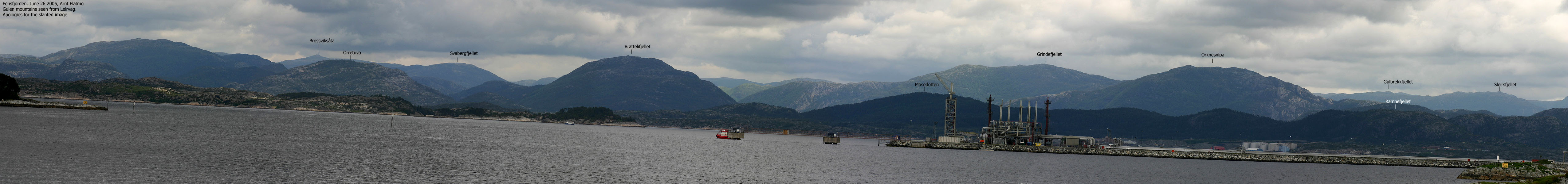
Gulbrekkfjellet


To Storenova and descent


No Javascript:
1 2 3 4 5 6 7 8 9 10 11 12 13 14 15 16 17 18 19 20 21 22 23 24 25 26


No Javascript:
Other hordaland mountains
 Other Masfjorden K. mountains
westcoastpeaks.com
Other Masfjorden K. mountains
westcoastpeaks.com

