
Norwegian Mountains, Hordaland
Storeflåtten attempt, Aug 30 2008
To the main Storeflåtten page (maps, route descriptions, etc.)
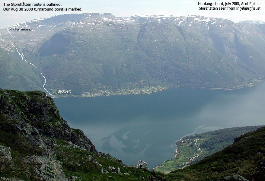
The route from Bjotveit
(Click for larger image)
Liv Nygård could have retired from her profession as a school teacher, spending the days of summer minding her beautiful fruit garden. But instead, she continues to help kids who need that extra bit off attention, that extra kind word, that extra clap on the shoulder and that extra care. Liv is a person that gives, without asking for anything in return. I have nothing but great admiration for Liv. She is also my oracle when I try to figure out what animal, plant or feature I've photographed.
There's a Mt. Everest for everyone, and I'm boldly assuming that Storeflåtten is Mt. Everest for Liv. Her first attempt, perhaps not quite wholeheartedly, happened in 2005. Her second attempt, in 2006, didn't bring her to the summit either. That's when I said I would make the trip from Ålesund and walk up the mountain with her. Liv would be standing on top of Storeflåtten in the summer of 2007! There was no doubt in my mind. Unfortunately, various obstacles didn't allow us to find a good time for the trip. This was quite disappointing, because Liv had put in a lot of training for it. In the summer of 2008, her troublesome knee was downright bad news, but it got slightly better during August. We then decided to give it a go. August 30 2008 would be Everest day.
Although Storeflåtten is not a difficult mountain, it is certainly NOT a stroll. You start down by the fjord and walk 1600 vertical meters, and more than 10 kilometers, one way. You'll have to be in shape for this mountain, otherwise you can easily be having quite a bad day up there. I walked this mountain in 2003, and was already familiar with it. I knew that Liv very much appreciated company on this trip, and I appreciated the opportunity and her trust in me as a mountain guide.
I drove down to Hardanger Aug 29 and Liv offered me a nice guestroom. It was nice to see Liv again. Her dog Sheeba too, and her new cat Kinso. It was nice to see a dog and a cat together, and I thought back on the days when I had Tussa and Troll. I missed them both, and decided that when I had proved whatever I want to prove in the mountains, I'll get myself a cat and a dog again. Later in the evening, I took Liv for a drive in the Tiger. She had never been for a drive in a convertible sportscar before, and she will probably not forget it any day soon..

On the way to Hardanger. Patience is required..
(Click for larger image)
On the morning of Aug 30, we drove from Jåstad to Bjotveit, a 1,5h drive. It was only 5 years since I hiked Storeflåtten, but it seemed like a lifetime. I looked forward to revisit the area. Sheeba came along for the trip, and seemed to settle in the utility compartment behind the seats. The weather forecast had promised a sunny day, but clouds were still covering the mountains. We hoped that the fog would burn off during the morning hours.
8:30am, we were on our way to Storeflåtten. It was important for me that Liv found her own pace, and she seemed to be doing just fine. Worse off was Sheeba, who lay down after a while. We were prepared for this, and I had brought my small-dog-compatible backpack. Initially, Sheeba didn't feel like entering this mysterious bag, but once in, she seemed quite content. I figured I could just as well carry her all the way upwards, and that she could spend her energy on the descent. I found it a bit odd that the second time I ascended Storeflåtten, I was carrying another dog.

On the trail. Some of us, at least
(Click for larger image)
10:45AM, we arrived at Lake Vatnasetevatnet (870m), and I was very happy about the time. We were practically halfway there. The only question was; how was Liv feeling? She definitely felt the ascent, but was ready to move on after a break by the lake. The weather did not live up to the promise. Although we sometimes could see Storeflåtten's summit, it didn't seem as if it would clear up any time soon.
We entered Skoddedalen (Fog valley) in thick fog. We were off-trail, on a direct route towards a ridge that would take us up to the plateau east of Storeflåtten. The terrain was getting gradually rougher, and I noticed that Liv was getting tired. After having walked 8Km and ascended 1220 vertical meters, we arrived on the ridge and sat down. Liv said she was a bit tired, and that she feared the descent if she pushed herself for the summit.
This was sad news. I really, really wanted her to be standing on top on this mountain, but not at any cost, of course. I knew that she would have the strengths to make it to the top, but the descent would be much harder and we could be running out of daylight. But I had no intent of pushing her. She would have to make the call, and she did. 1220m was the highest she had been on this mountain. Now she had seen the remaining hillside and could start to build confidence about her 2009 trip. Knowing her, I'm sure there will be one. And I'm sure she'll be taking in the views of beautiful Hardanger from Storeflåtten summit. One sunny day..

Storeflåtten seen from the lake
(Click for larger image)
Upon descent, the fog started to
burn off. We had all the time in the world, and took it nice and easy down the
mountain. Sheeba was very happy about walking again, especially now that there
was only downhill ahead. It was a gorgeous day when we reached the Bjotveit
trailhead. And even if we hadn't reached the top, it had still been a nice trip.
After yet another enjoyable drive along (and around) Sørfjorden, Liv
served a nice and tasty dinner. And beer too! Oh, it's hard to be a mountain man
![]()
Early, early next morning, I drove back to Ålesund, visiting Nipahøgdi (1375m) along the way.


