
|

Snaufjellet and Pynten seen from RV57(No Javascript) |
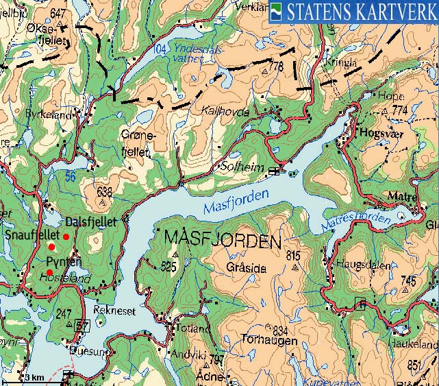
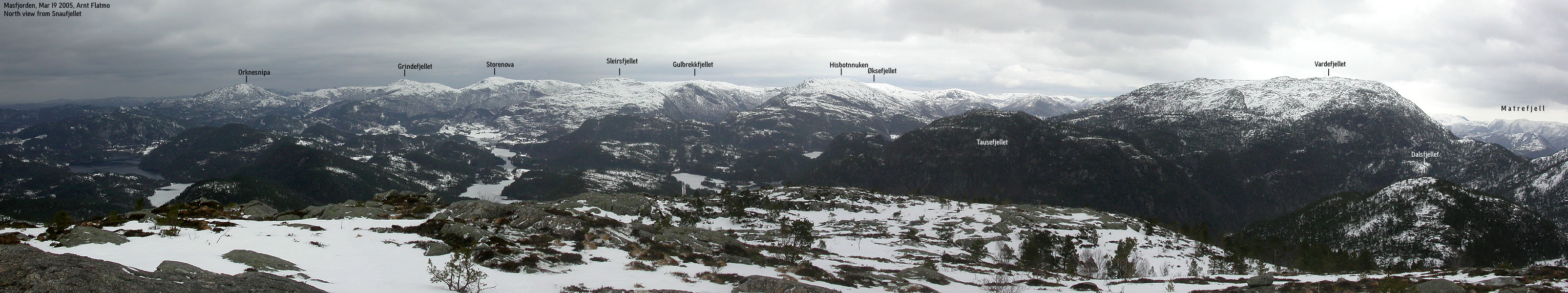
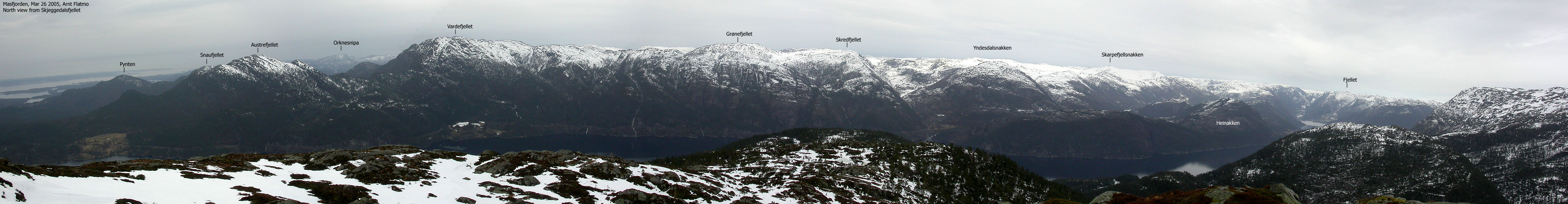
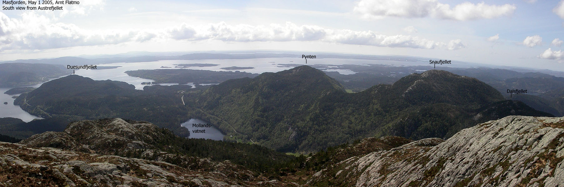
Snaufjellet, Pynten and Dalsfjellet are located north of where Masfjorden drains to Fensfjorden, and appear as anonymous forest hills compared to the higher Masfjorden mountains. The three tops are found on a ridge east of Mollandsdalen valley. Although this forest ridge has steep and unfriendly terrain, the ridge walk offer no challenges.
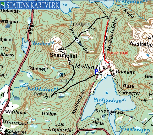
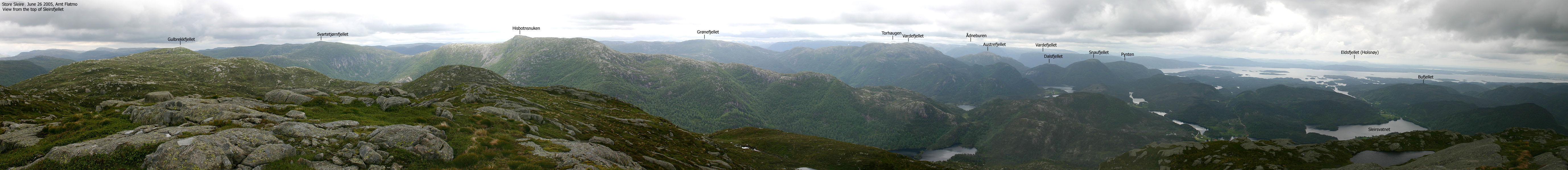
The best point of access is the place Molland, where you have the possibility to make a round trip of your hike. You can also include Austrefjellet (528m) on your hike. Your primary views are the mountain range across Nord-Gulen and the Masfjorden/Matre mountains towards the east. The characteristic Ådneburen landmark (797m) can be seen from all of the tops. Several names exist for these tops. Some refer to Pynten as "Hatten" or "Storafjellet". Pynten and Dalsfjellet do not have their names on the M711 maps. The names were however found on Økonomisk Kartverk (5m contours).
Snaufjellet (M711: 425m, Ø.K: 425,43m) has a primary factor of 277m towards the higher Austrefjellet (528m). The saddle is found in Mollandsdalen valley. Ref. Økonomisk Kartverk map (5m contours), you cross the 150m contours on the high route, but not 145m. The saddle height has been interpolated to 148m.
Pynten (M711: 373m, Ø.K: 368,5 ~ 369m) has a primary factor of 126m towards the higher Snaufjellet (425m). The saddle is found between the two tops, along the ridge. Ref. Økonomisk Kartverk map (5m contours), you cross the 245m contours on the high route, but not 240m. The saddle height has been interpolated to 243m. According to my GPS reading, 373m seems more correct.
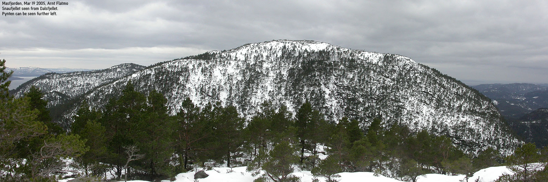
Dalsfjellet (M711: 359m, Ø.K: Highest contour is 355m) has a primary factor of 111m towards the higher Snaufjellet (425m). The saddle is found between the two tops, in Breidskardet pass. Ref. Økonomisk Kartverk map (5m contours), you cross the 250m contours on the high route, but not 245m. The saddle height has been interpolated to 248m.
Notes: Class ratings are in reference to YDS. Click here for more information.
The trails described below are not necessarily the *easiest* trails to this mountain.
|
Molland - all tops round trip(winter)
|
|
From Bergen, follow highway E39 nortbound. After the Nordhordlandsbrua bridge, pay (NOK 45,- for passenger cars per March 2005) at the Toll station. Drive 2,4Km and turn left onto highway RV57 (Leirvåg). Follow highway RV57 for 36,6Km, then turn right right towards the Leirvåg - Sløvåg ferry. The ferry is 1,4Km from the exit. Note that the ferry sometimes stop by Skipavik, west of Sløvåg.
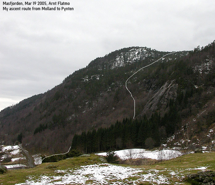
From Sløvåg, continue 3,9Km. Turn right onto RV570 towards Duesund. Follow this road for 11,8Km and turn left towards Molland. Drive 1,4Km and find parking on a turnout on the left-hand side just before a creek, and before you reach the Molland houses.
Alternatively from Bergen, follow highway E39 past Jernfjelltunnelen tunnel north of Matre and turn left towards Sløvåg. Follow this road to the Molland exit.
Pynten
From the parking, walk south of the small spruce forest and maintain a west to southwest direction all the way to the summit. The terrain is easy, but you will have to find your own way through the forest. The distance from the parking to the summit is approx. 1,2Km. No cairn marks this summit.
Snaufjellet
From Pynten, descend northeast towards the pass between Pynten and Snaufjellet. You will have to follow the ridge between the tops. This is obvious, as the south side of Snaufjellet is nearly vertical. Pass over a hump, descend down to another pass and start ascending Snaufjellet. The ascent consists of constantly finding a way up to your right until you are on the high plateau. The summit is marked by a proper cairn.
Dalsfjellet & return to the trailhead
Descend from Snaufjellet, aiming directly at the meadow southwest of Dalsfjellet. The terrain is easy all the way to Dalsfjellet, looking aside from bushes. The summit is marked by a lower cairn, compared to the Snaufjellet summit cairn. Descend northeast from Snaufjellet. At 250m elevation, you may be forced slightly to the east in order to avoid a steep section. Maintain the northeast direction all the way to 120m elevation, where you find a way to descend the cliffs to your right. After a short pitch through the forest, you join the forest road between Molland and Tenndalen. After a short ascent up the forest road, you're on top of Mollandsdalen valley and can follow the road all the way back to the car.
|
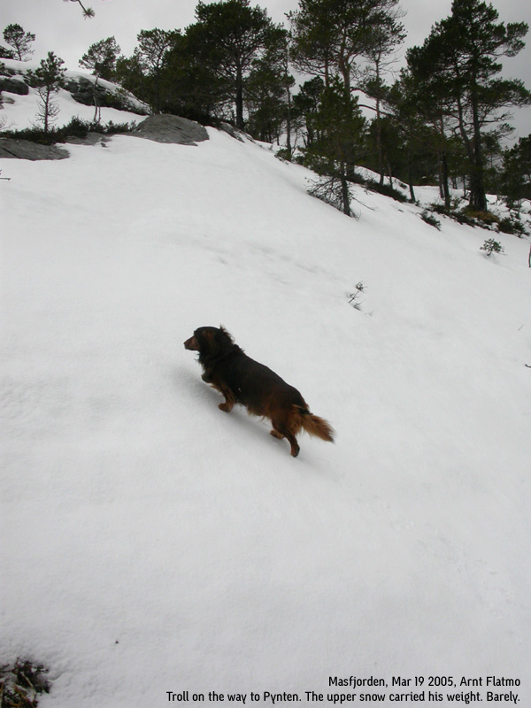
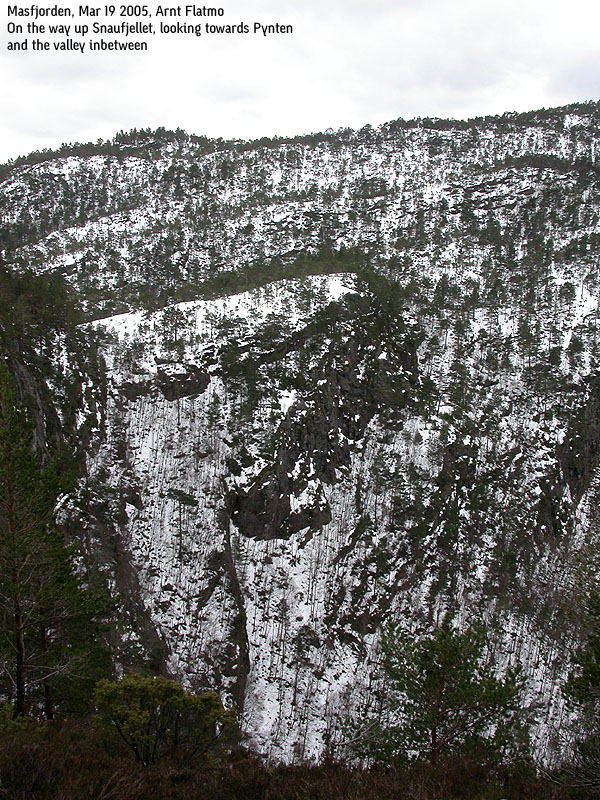
Trip report Mar 19 2005I was not in mood for hiking or skiing today. Neither the mind nor the body was very co-operative, but I had to do *something*. I decided to go to Masfjorden, and visit some lower forest hills. I had my eyes set on a forest walk that could result in 4 tops being ticked off my Hordaland mountain list. I was concerned about the amount of snow, but hoped that the recent rain had done something good. I took the Leirvåg - Sløvåg ferry and drove to Molland. I rang the doorbell at the nearest house and got some good advice, especially on how I should descend Dalsfjellet. The east side of Dalsfjellet (facing Mollandsdalen) is steep and unfriendly, and a few good pointers would come in handy. The man I talked to must have silently wondered why the heck I was going up this forest, but never asked. I thanked him for the useful information, and drove to the starting point. I left the car 11:30AM with Troll (the dog) in the backpack. I was going for a direct approach towards Pynten. The initial part of the forest route was easy due to minimal snow. But long before I reached 100m elevation, I was stomping in deep snow. I did keep a good pace, and reached Pynten within 45 minutes. I had let Troll out of the backpack above 300m elevation, as the snow was harder. The snow carried his weight, but not mine. While I was able to plow the snow further down the forest, the snow now carried for a fraction of a second before I broke through. I felt the fatigue come upon me. Or was it irritation? The goal was to hike across Pynten, Snaufjellet and Dalsfjellet. If I had any strengths left, I would also go for Austrefjellet. Austrefjellet meant additional 380m of vertical ascent on top of the 680m required for the first three forest hills. Already on Pynten, I was no longer convinced that I would be standing on top of Austrefjellet today. The descent from Pynten was painful. The snow was hard (but not hard enough to carry) and my legs suffered from breaking the snow) It felt like the hard crust cut right into the leg-bone. But soon, I was on my way up Snaufjellet. The ascent involved always looking out for a place to climb higher up to my right. I didn't ran into any problems and stood on top of Snaufjellet 1 hour after reaching Pynten. Troll was now and then let out of the backpack, but was in general miserable. It was windy and cold, and he didn't seem happy with the backpack. Everytime I broke through the snow, I heard a deep OOMMPF from the backpack. And throughout the hike, there were many OOMMPFFs. On Snaufjellet, I decided to head across Dalsfjellet and then call it the day. The descent from Snaufjellet was extremely painful, as the snow crust kept hurting my legs. On average, the snow reached halfway up to my knees, making every step a small effort. By 14:00PM, I was standing on top of Dalsfjellet. The steep northwest ridge on Austrefjellet looked very tempting. I decided to make the final decision once down in Mollandsdalen valley. The descent from Dalsfjellet was the most tricky part of the route, but after a small detour I was finally able to join the forest road in Mollandsdalen. After 3 hours of walking in deep snow, I was soaking wet and confessed to myself that enough was enough. I would return to Austrefjellet on a sunny day. I have had way too many hikes in the Masfjorden area in grey weather. Troll was let out once we hit the forest road, and walked back to the car, which we reached 14:45PM. It was a bit difficult to summarize this hike. I had spent a precious Saturday by hiking three forest hills, all below 430m elevation. I hadn't even walked a Norwegian mile (10Km). It didn't seem like much, but nevertheless, I felt there had been some effort. My legs were a bit tired and sore. I concluded that I should have gone skiing, but since I didn't, ticking off 3 mountains on my list wasn't a bad substitute.
Pictures from the Mar 19 2005 hike
Move cursor to read notes, and click on the images to see full version.
Pynten
Snaufjellet
Dalsfjellet & return to trailhead
No Javascript: 1 2 3 4 5 6 7 8 9 10 11 12 13 14 15 16 17 18 19 20 21 22
|


No Javascript:
Other hordaland mountains
 Other Masfjorden K. mountains
westcoastpeaks.com
Other Masfjorden K. mountains
westcoastpeaks.com


