
Norwegian Mountains, Møre og RomsdalNipa/ Gjøna, 531m
|
| Fylke/Kommune : | Møre og Romsdal/Sande | ||||||||||
| Maps : |
1119-III Vanylven (Statens Kartverk, Norge 1:50 000)
1119-IV Fosnavåg (Statens Kartverk, Norge 1:50 000) |
||||||||||
| Primary factor : |
Nipa: 163m Egga: 93m Haugshornet: 53m |
||||||||||
| Hiked : | Mar 2007, Apr 2009 | ||||||||||
| See also : |
| ||||||||||
| See also : | Other Sande mountains |

Saursegga and Nipa/Gjøna
(Click for larger image)
An interesting mountain ridge is found between Gjerdsvika and the Gursken fjord/Haugsbygda. This ridge has two distinct tops. The highest point on this ridge is called Nipa on the Haugsbygda side, and Gjøna on the Gjerdsvika side. Saursegga (often just referred to as Egga) is located closer to Haugsbygda . The walk across Saursegga and to Nipa/Gjøna is one of the finest walks on Gurskøya island.
Via Haugshornet, the ridge merges with the mountains further east (Nørdbergsheida, Storetua, Røddalshorn). This mountain region is separated from the northern Gurskøya mountains by the Simavatnet - Raudsandvatnet - Storevatnet lakes and drains.
Nipa/Gjøna and Saursegga is normally reached from the Haugsbygda side, but this web page will also describe a route (partly off-trail) from Gjerdsvika.

Nipa/Gjøna
(Click for larger image)
Nipa/Gjøna (Norge 1:50,000: -, Økonomisk Kartverk: Highest contour is 530m (set to 531m on this site), UTM 32 V 320706 6906855) has a primary factor of 163m, towards the higher parent mountain Storetua (592m). The saddle (approx. UTM 32 V 322815 6905905) is found between Hanen and Haugshornet. Ref. Økonomisk Kartverk (5m contours), the saddle height is defined through a fixed point - 367,5 ~ 368m.
Saursegga/Egga (Norge 1:50,000: -, Økonomisk Kartverk: Highest contour is 515m (set to 516m on this site), UTM 32 V 321436 6906443) has a primary factor of 93m, towards the higher parent mountain Nipa (531m). The saddle (approx. UTM 32 V 321044 6906641) is found between Egga and Nipa. Ref. Økonomisk Kartverk (5m contours), the saddle height is within the range 420-425m, interpolated to 423m.
Notes: Saursegga's 1:50,000 514m map point (513m on ØK.), is located 380m southeast of the high point.
Haugshornet (Norge 1:50,000: 431m, Økonomisk Kartverk: 431m, UTM 32 V 323114 6905818) has a primary factor of 53m, towards the higher parent mountain Nørdbergsheida (509m). The saddle (approx. UTM 32 V 323923 6905771) is found between these two tops, south of Telebergvatna. Ref. Ref. Økonomisk Kartverk (5m contours), the saddle height is within the range 375-380m, interpolated to 378m.
Table of
GPS waypoints from various visits. Over time, one will hopefully see a
conclusive pattern:
| Nipa/Gjøna | Saursegga high point |
Saursegga 1:50,000 514m point |
| 529m | 499m(!) | 511m |
| 537m | 521m | 512m |
| 535m | 519m | 518m |

Saursegga
(Click for larger image)
Google's interactive map. You can zoom, pan and click on the markers.
|
|
|
|
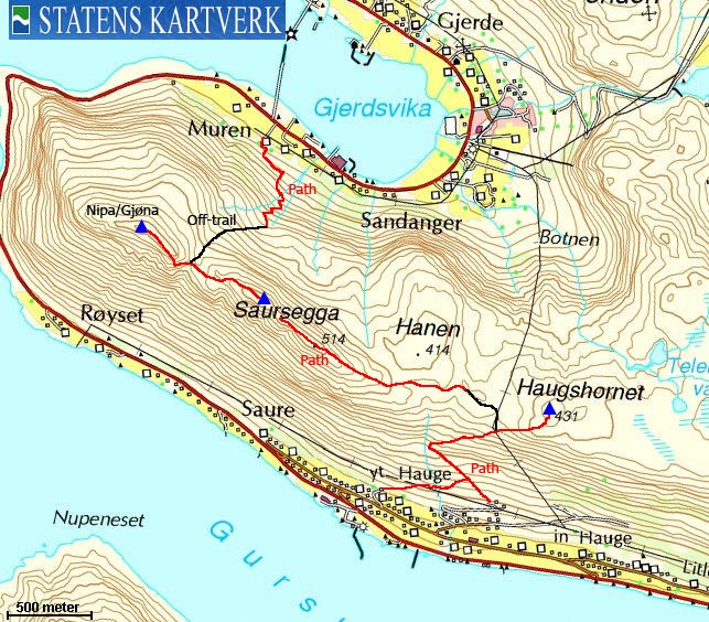
Route 1: Haugsbygda - Nipa via
Saursegga (summer/autumn)
|
|
Access
(all distances are approx. distances)
The nearest larger city is Ålesund. From Ålesund, follow highway E39 towards Bergen, and then RV61 towards Hareid. Take the Sulesund - Hareid ferry, and from the roundabout in Hareid, follow RV61 19,8km to the RV61/RV654 junction at Myrvåg, 1km after the Dragsundet bridge. You pass Ulsteinvik and make a sharp right turn (Måløy) along the way.
From the RV61/RV654 junction at Myrvåg, drive 12,6km to the Gursken fjord, turn right towards "Haugsbygda/Moldtustranda" Drive 3,9km and turn right towards "Haugsbygda/Vonheim".
After 1km on this side road, turn right. Drive 200m, then turn left. After 500m, turn left and find parking at the end of the road.
The route
From the parking, follow the path to the northwest. You see two gates. Ignore the first gate, then go through the second, which will get you on the right track. The path continues northwest (in the direction of Saursegga), then it turns northeast at 210m elevation. This path continues all the way to Haugshornet.
In order to get to Saursegga, head northwest at approx. 380m contour, and aim for the 380m contour located between Hanen and Haugshornet. If you haven't found the path already, you should be able to find it on top of this contour. Pass Hanen on the south side before you the path takes you up Saursegga. None of the Saursegga points are marked, but you will see a single rock in the grass at the high point.
Descend into the Saursegga - Nipa/Gjøna pass and follow the path which is found on the south side (left) of the pass. The path climbs steep before you top out on the Gjøna ridge. Nipa summit (which has a summit marker) is 200-250m to the northwest.
Variation to the above route
ref. Access above: ....After 1,4km on this side road, locate a road going up to your right. Find a place to park. Follow the road 150m up to two houses. A marked path begins between these two houses, and continues northeast until it joins the route described above, at approx. 150m elevation.
|
Route 2: Muren (Gjerdsvika) - Nipa/Gjøna (summer/autumn)
|
|
Access
(all distances are approx. distances)
The nearest larger city is Ålesund. From Ålesund, follow highway E39 towards Bergen, and then RV61 towards Hareid. Take the Sulesund - Hareid ferry, and from the roundabout in Hareid, follow RV61 19,8km to the RV61/RV654 junction at Myrvåg, 1km after the Dragsundet bridge. You pass Ulsteinvik and make a sharp right turn (Måløy) along the way.
From the RV61/RV654 junction at Myrvåg, drive 12,6km to the Gursken fjord, turn right towards "Haugsbygda/Moldtustranda" Drive 10,5km (passing Haugsbygda and Gjøneset) to Muren in Gjerdsvika. Locate a farm on your right-hand side, almost directly opposite to the sea wall (molo in Norwegian). Find an appropriate place to park, or drive up to the farm and ask for permission to park there.
The route
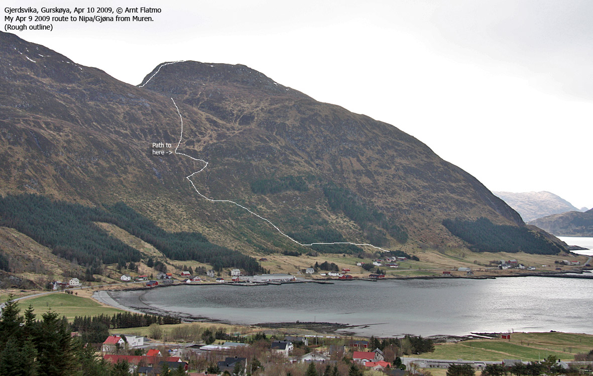
Route to Nipa/Gjøna from Gjerdsvika
(Click for larger image)
The path begins behind the farm, and can be a little difficult to find. It runs to the right of the forest behind the farm, ascends 60m (distance) straight up, then continues 150m southeast (left) through the forest. From the other side of the forest, it runs straight up 100m (distance) before it turns south towards the creeks from the mountain. From the first creek, the path switchbacks into a mini-valley directly below Saursegga. The path is marked by sticks where can be difficult to see it.
The path ends by some ruins below Saursegga, but you should
before then turn southwest and continue (off-trail across turfs and bog) towards
the pass between Nipa/Gjøna and Saursegga. From the pass, follow the path
described in route #1 above.
 westcoastpeaks.com
Other Møre & Romsdal mountains
Other Norwegian mountains
westcoastpeaks.com
Other Møre & Romsdal mountains
Other Norwegian mountains


