
|

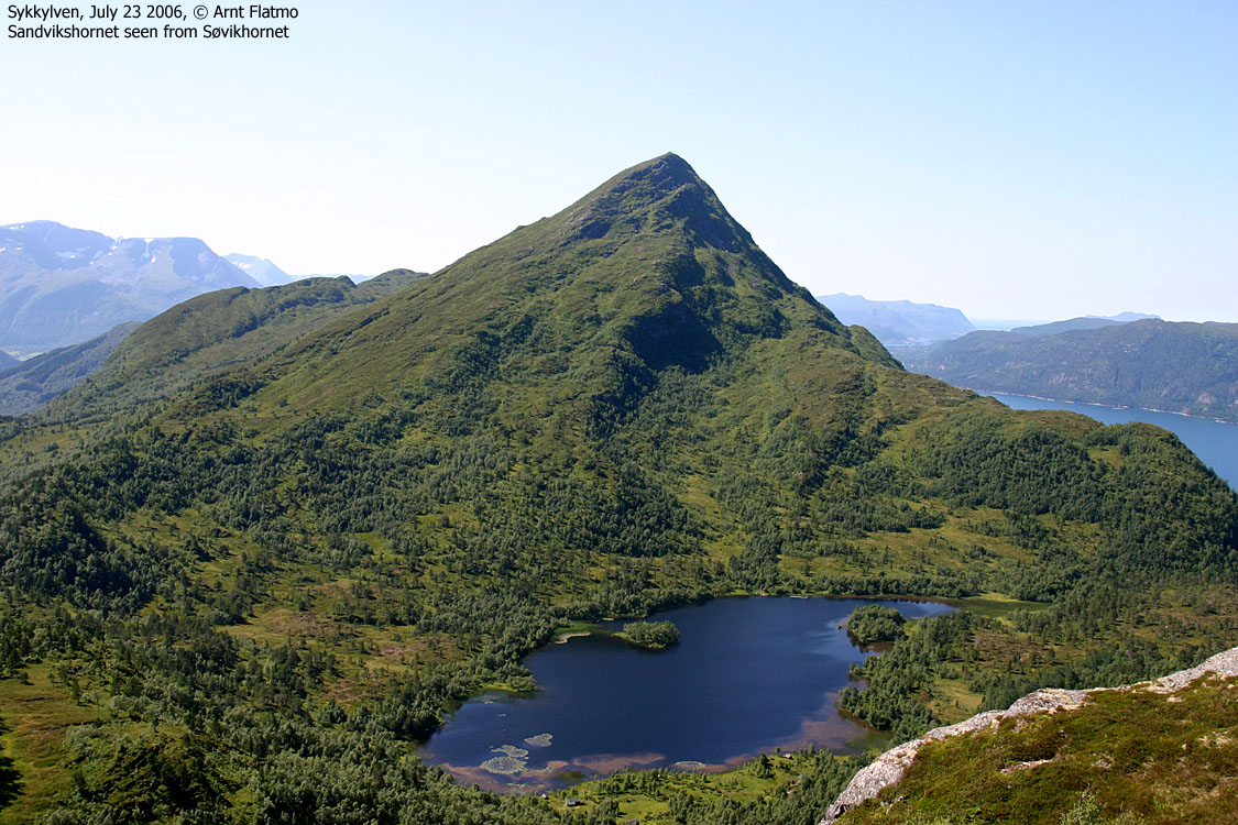


Sandvikshornet and Søvikhornet have their names from the farms/places Sandvik and Søvik by Storfjorden. Sandvikshornet is a tremendous, and popular viewpoint above Storfjorden. Søvikhornet is much less visited. Søvikhornet has a lover elevation, a lower primary factor and no summit cairn. Seen from the east, Sandvikshornet stand out as a near-perfect pyramid shape, while the twin-topped Søvikhornet becomes a bit more anonymous in the front.
It seems as most Sandvikshornet visitors choose to hike from Hjellane above Sykkylven. This route is approx. 2Km longer than the route from Løset, described on this page. Another "upside" about the Løset route is that you have the option to include Søvikhornet on your hike.
From Løset, you can reach both Sandvikshornet and Søvikhornet on paths. The tops share a common trail up to the forest ridge, south of Løsetvatnet. The paths up to the two tops are less distinct than the trail to Løsetvatnet, but they are fairly easy to follow.
The view from Sandvikshornet is a true delight, but because of the low mountain height, the view doesn't extend very far. But if you want to get a good overview of the Ålesund, Haram, Skodje, Ørskog, Vestnes, and Sykkylven region, Sandvikshornet is a good top to visit. While Søvikhornet is a bit more cumbersome, compared to the Sandvikshornet path, both tops are in the "family hike" category.


Sandvikshornet (Norge 1:50,000: 876m, Ø.konomisk Kartverk: 875,53m, UTM 32 V 379279 6924360) has a primary factor of 788m towards the higher parent mountain Vardefjellet (891m). The defining saddle (approx. UTM 32 V 383318 6924165) is found east of Lake Litlevatnet. Ref. the Økonomisk Kartverk map (5m contours), the saddle is within the range 85-90m, interpolated to 88m.
Søvikhornet (Norge 1:50,000: 706m, Ø.konomisk Kartverk: 706,33m, UTM 32 V 382457 6925114) has a primary factor of 363m towards the higher parent mountain Sandvikshornet (876m) The defining saddle (approx. UTM 32 V 381355 6924170) is found on the forest ridge S of Lake Løsetvatnet. Ref. the Økonomisk Kartverk map (5m contours), the saddle is within the range 340-345m, interpolated to 343m.
Notes: Class ratings are in reference to YDS. Click here for more information.
The trails described below are not necessarily the *easiest* trails to this mountain.
|
Løset - Sandvikshornet - Søvikhornet (summer/autumn)
|
|


Access
From Ålesund, follow highway E39 towards Bergen, and then highway RV60 (Stranda) to the Magerholm - Ørsneset ferry. This ferry runs quite often; every 20 minutes in the busy hours of the day. From Ørsneset, follow RV60 (Stranda) approx. 2,6Km and turn left towards "Ramstaddal". Follow this road 7,8Km to Løset. You have a road to your right and a road up to your left. Turn right and park near a standalone garage.


The route
Sandvikshornet:
Head up to the farm that is located EAST of the powerline from Løsetvatnet. Head up a short hill between the farm house and the barn and enter a forest path that will take you up to the forest ridge at 350m elevation, where you run into a trail fork. Per July 2006, there was a salt stone for the sheep at the trail fork.
Follow the path along the forest ridge, as it gradually climbs up the Sandvikshornet southeast ridge. Sandvikshornet is marked by a cairn and a trig. point.
Søvikhornet:
Descend back to the trail fork on the forest ridge. Turn left at the fork and follow the trail towards Løsetvatnet for just a few meters. If you pass a rock-fence and the trail begins to descend towards Løsetvatnet, you've gone too far. Backtrack a few meters and locate a narrow forest path that continues northeast along the forest ridge.
This path will take you to a distinct meadow. Head straight across (the shortest route) and locate the path that continues up to the ridge. On the ridge, you run into a cliffband that you ascend on the left-hand side. Once back on top of the ridge, the path runs on the south side of the ridge proper until you are out of the forest. At approx. 580 elevation, the path seems to go the wrong way (northbound). Turn right (northeast) and follow the terrain as you see fit up to the summit. The summit is not marked by any cairn. There are two seemingly equally high tops. The first you arrive is most likely the high point. Descend your ascent route.


 westcoastpeaks.com
Other Møre & Romsdal mountains
Other Norwegian mountains
westcoastpeaks.com
Other Møre & Romsdal mountains
Other Norwegian mountains

