
Norwegian Mountains, Møre og RomsdalRossfjellet, 118m
Rossfjellet
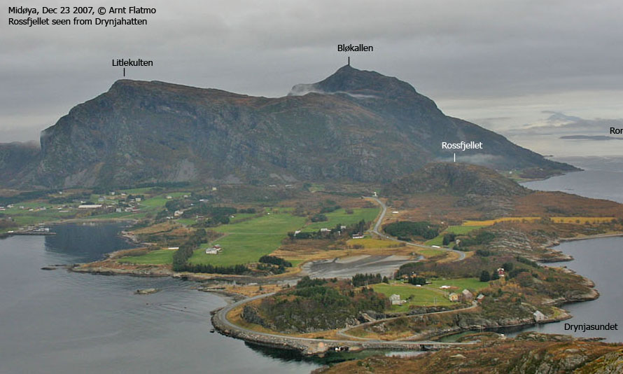
IntroductionAs westcoastpeaks.com has chosen 100m primary factor as the definition of a mountain top (thus, minimum height is also 100m), then hills like Rossfjellet are bound to find their way to the mountain lists. This is for the most part a coastal, more than an inland issue. Other hills with similar height, such as Harøyburet on Harøya and Æafjellet on Fjørtofta have actually quite good views towards the mainland peaks. You'll see a number of mountain tops from Rossfjellet too, although its higher neighbour Bløkallen offers much better views. Rossfjellet is only a ten minute walk (or less) on a dirty path, and less than 100 vertical meters. Primary factor:Rossfjellet (Norge 1:50,000: 118m, Økonomisk Kartverk.: 117,74m , UTM 32 V 376685 6949511) has a primary factor of 100m towards the higher parent Bløkallen (522m). The defining saddle (approx. UTM 32 V 376887 6950026) is found near Gangstad. Ref. Økonomisk Kartverk (5m contours), the saddle is within the range 15-20m, interpolated to 18m. There is also a fixed point (17,1m) which could possibly raise the primary factor to 101m.
Google mapGoogle's interactive map. You can zoom, pan and click on the markers.
Trail descriptions
Notes: Class ratings are in reference to YDS. Click here for more information.
The trails described below are not necessarily the *easiest* trails to this mountain.
Access (all distances are approx. distances) From Ålesund, follow highway E136->E39 towards Åndalsnes. From the E136/E39/Olsvika roundabout near Breivka, follow E39 13,3Km. Turn left onto highway RV661 (Skodje/Brattvåg/Vatne). Pay toll at an unmanned toll booth (coins + credit cards, AutoPass) 1,5Km later. 8,7Km after you left E39, you reach the 659(Brattvåg)/661(Vatne) junction. Turn left towards Brattvåg. 13,6Km later (from this junction), turn right towards the ferry to Dryna, and continue 600m down to the ferry harbor. On Dryna, turn right and drive 4,2Km. You now have Rossfjellet to your right. The Molde/Ramsvika road junction is only a few hundred meters ahead of you. You'll find parking (1 car) where the path begins. The route From the parking, follow the path 80m to the southeast, then
turn left and head northeast up a ridge, passing a steep cliff to your right.
The path curves around this cliff and you'll be heading southeast to the top. On
the top you will find a trigonometric marker (fallen per Dec '07). Descend your
ascent route.
Trip notes and pictures, Dec 23 2007
I visited Rossfjellet after having been to Litlekulten. I left the car 13:44PM and reached the top 13:50PM. After a quick round of pictures, I was back at the car 13:56PM, in good shape for the 14:15PM ferry from Dryna.


No Javascript:
Other pictures:
|


