
Norwegian Mountains, Møre og RomsdalFausateighornet, Storheirøra and Sjurlihornet from Nysætervatnet, Oct 13 2007This route is described as route #2 on the Ramstadvarden main page.
Intro The only reason for not having been to these tops yet, was getting back to the car without a) walking back the same way or b) walking up/down Fasteindalen. No fun in that. But then my colleague Arngeir came to rescue. He has a cabin by Nysætervatnet and he was interested in these tops too. Now that he was spending a week up there, the transport problem was solved. Bad morning From time to time, my muscles in the upper body give me grief. They contract and nerves get squeezed. I woke up this Saturday with a hangover-like headache and considered strongly calling in sick. But the need for a good hike was stronger. A mix of painkillers turned out be the solution for the problem. It was a dose that would have made the Doctor slap my face, and I considered writing a note to myself; remember to blink. It's good for the eyes. And off we went Arngeir was waiting for me at the Årsetsætra trailhead. We parked my car there and drove up to Nysætervatnet. I looked forward to a hike that did not include carrying a dog. Thanks to my excellent neighbour Pål for looking after Troll! We left the trailhead 11:13AM and were happy to find a path that seemed to lead all the way to Fausateighornet. The forecast had promised a cloudy day, but it wasn't supposed to rain much. A most excellent forecast it was. It was indeed cloudy, and only a couple of light showers passed us during the hike. Fausateighornet We reached the top of Fausateighornet at noon. Two tall cairns marked the summit, and I was impressed by them still standing. The ascent had been a doddle, and I was by no means tired. Yet the blood pump was working hard. Deep, deep down I realized I had a strong headache, but thanks to the be-your-own-doctor event this morning, I was still feeling human. Arngeir was good company. We had only been on two hikes together before this one. A scramble up Trollråsa (Sukkertoppen) and a nice group trip to Straumshornet in Sykkylven. He's fit, indeed, well above the average, and while taking time needed on the tops, we kept a fair pace once we got moving. Sjurlihornet and descent We passed Storheirøra 12:30PM and continued up to Sjurlihornet. The terrain was quite easy and .. slightly boring. We enjoy some "action", and hoped that the descent from Sjurlihornet would give us some problems. We reached Sjurlihornet 13:00PM and stopped a few minutes for pictures. Then we headed down to the top of the steep cliff above Forsevatnet. Yup, this could be interesting. We went down to a ledge to get a better overview. We couldn't descend further from here. The ridge splitting Årsetvatnet and Forsevatnet was a guaranteed route down, but that meant an additional kilometer of walking. Below us was a ridge that we knew would take us down to Forsevatnet. If we just could get on it. A cliffband between us and this ridge prevented further progress. But I was convinced that if we just continued westbound, we would find a route, and sure enough.. The descent was steep, but never risky in any way. We began traversing Forsevatnet quite high, so by the time we reached the lake, we were already at the western end. We continued off-trail down to Årsetvatnet, where we followed a nice path along the shore, to the dam. We had both walked the route from the dam to Årsetsætra on our separate trips to Ramstadvarden, so we decided to run down the path. We had an OK pace down the forest. The time was 13:43PM when we started to run at 580m elevation, and 13:53PM when we reached the car at 210m. We drove back up to Nysætervatnet and parted. Ouch.. After this efficient descent from the mountain, my body was in havoc. The pills were out of the system by now, and my head was ready to explode. The muscles in the back were too sore to touch, and the only remedy was to follow the stretching procedure that my physiotherapist had ordered. But Fjellsætra wasn't the place. I had to get back home. With the car window open, I was shivering. With the car window closed, I was drowning in sweat. It felt exactly as returning from a 4000m mountain with Acute Mountain Sickness. And boy, do I know something about that. In plain survival mode, I got myself back to Ålesund. I was home 15:15PM and sunk down in the chair, trying to gather strength for the upcoming exercise. From 15:30PM to 20:30PM, I walked back and forth between the chair and the doorway, where the stretching took place. Little by little, life as I like to know it got restored, and by 21:00PM, I could attend to the slightly confused dog. What a day...
Pictures from the Oct 13 2007 tripNote: Poor image quality due to difficult lighting conditions.
Slideshow:
Map of the route
To Fausateighornet
Wide-angle view from Fausateighornet
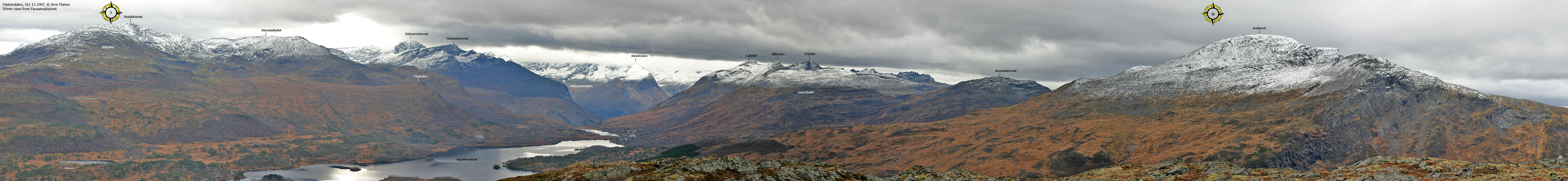
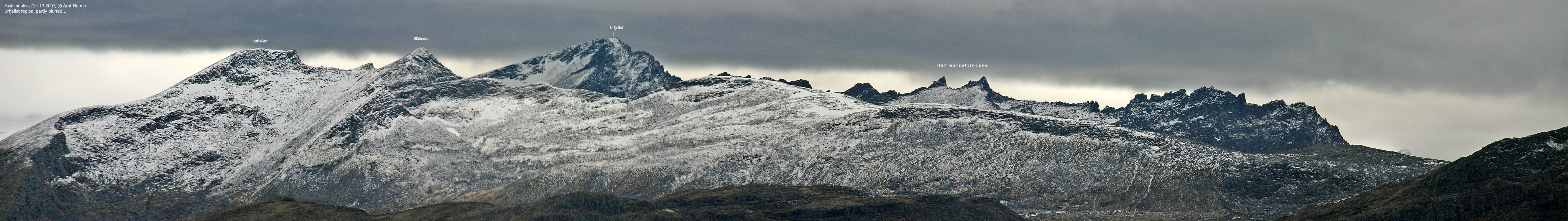
50mm views from Fausateighornet
Other pics from Fausateighornet
Storheirøra
Sjurlihornet
Descent
No Javascript: 0 1 2 3 4 5 6 7 8 9 10 11 12 13 14 15 16 17 18 19 20 21 22 23 24 25 26 27 28 29 30 31 32 33 34 35 36 37 38 39
|


