
Norwegian Mountains, Møre og RomsdalProsten, 1263m
|
| Fylke/Kommune : | Møre og Romsdal/Rauma,Vestnes | ||||||||||
| Maps : |
1220-II Vestnes (Statens Kartverk, Norge 1:50 000)
1320-III Åndalsnes (Statens Kartverk, Norge 1:50 000) |
||||||||||
| Primary factor : |
Prosten: 673m Svartevasstinden: 149m Trolltinden: 111m |
||||||||||
| Hiked : | Apr 2006 (Trolltinden), July 2008 (Svartevasstind), Aug 2008 (Prosten) | ||||||||||
| See also : |
| ||||||||||
| See also : | Other Vestnes and Rauma mountains |

Trolltinden - Svartevasstinden - Prosten
(Click for larger image)
Trolltinden, Svartevasstinden and Prosten are the most prominent peaks on an isolated mountain range, located just east of Tresfjorden, a branch of Romsdalsfjorden. Blåtindane, Trollstolen and Blåstolen are also part of this massif, but are documented on separate pages. There are also a number of other, lower tops such as Grøntinden, Kaldtinden and Midttinden, but this page will focus on the primary peaks.
Most of the mountain tops belong to Rauma, except for Blåtinden, Midttinden, Trolltinden and Svartevasstinden, which are found on the Vestnes/Rauma border.

Svartevasstinden
(Click for larger image)
Svartevasstinden is not the highest of the peaks, but by far the most challenging. This is the only top on this massif that you can not easily ascend and descend. This page will describe a route from Daugstadsætra, which involves climbing with rope. This route is (supposedly) the same as the route described in the book "Til Fjells i Vestnes". However, local experts claim that Svartevasstinden can be scrambled on a different route. This information will be added, when obtained. In any circumstance, you will be moving in a very exposed landscape, and as most people (of the few that visit this peak) will choose to rappel down, a rope is needed anyway. See the "Route Descriptions" section further down.

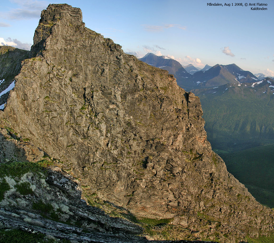
Kaldtinden - Grøtinden - Prosten
(Click for larger image)
Prosten, Grøntinden and Kaldtinden offer a very nice round trip in summer/autumn. The normal routes to Prosten run from the Måndalen valley, either via Venåsdalen or Modalen. This ridge traverese should fit most hikers, although there is at least one point between Grøntinden and Prosten that requires concentration.
Prosten is best skied from Venåsdalen, while Grøntinden and Kaldtinden offer nice slopes for skiing into Modalen. If Venåsdalen is your entry point, then Blåtindane are also within close distance.
Prosten's northeast ridge is not documented on this page, but pictures can be found on the Prosten page (coming soon). This ridge looks very interesting, and chances are that you can follow it without the use of a rope. This ridge will be properly documented at a later point in time.
Most people will (presumaby) ascend Prosten via Grøntinden, but it is quite easy to ascend Prosten via the lowest point on the Grøntinden - Prosten ridge through a neat (but steep) grassy slope.

Trolltinden
(Click for larger image)
Trolltinden, along with Midttinden and Blåtinden offer a very nice terrain for skiing. You can reach Trolltinden either from Daugstadsætra or Hjelvika.
The Trolltinden - Svartevasstinden ridge is indeed rugged, and should be of interest to mountaineers. For the most part, one can walk alongside this ridge, but the terrain is exposed and most people would enjoy the safety of a rope in this area.

The Svartevasstinden - Trolltinden ridge
(Click for larger image)
Prosten (Norge 1:50,000: -, Økonomisk Kartverk (ØK): -, Garmin's GPS map: 1263m, UTM 32 V 413701 6935499) has a primary factor of 673m towards the higher parent mountain Sandfjellet (1470m). The defining saddle (approx. UTM 32 V 411404 6934623) is found north of Lake Stavvatnet. Ref. Norge 1:50,000 (20m contours), the saddle is within the range 580-600m, interpolated to 590m.
GPS measurement on the summit cairn (which is level with the highest block on the northeast ridge) read 1271m, averaged over a 20-minute period (error margin 1,2m). Based on this reading, it is fair to assume that the mountain could be higher than 1263m (1269m is a fair assumption), as stated on the GPS map. The summit cairn is located 56m (!) north of point 1263m on the GPS map.
Svartevasstinden (Norge 1:50,000: -, Økonomisk Kartverk (ØK): -, Other internet sources: 1259m, UTM 32 V 412188 6935855) has a primary factor of 149m towards the higher parent mountain Prosten (1263m). The defining saddle (approx. UTM 32 V 412822 6935456) is found between these two tops. Ref. Norge 1:50,000 (20m contours), the saddle is within the range 1100-1120m, interpolated to 1110m.
GPS measurement on the summit cairn (approx. 1m high) read 1261m, averaged over a 10-minute period (error margin 0,8m). Based on this reading, it is fair to assume that 1259m is the correct height. The maps are completely wrong for the Svartevasstinden area. The highest contour is 1200m(!) and the high point is located 50m NW of the 1200m contour.
Trolltinden (Norge 1:50,000: 1241m, Økonomisk Kartverk (ØK): -, UTM 32 V 411666 6936584) has a primary factor of 111m towards the higher parent mountain Svartevasstinden (1540m). The defining saddle (approx. UTM 32 V 411885 6936082) is found between these two tops. Ref. Norge 1:50,000 (20m contours), the saddle is within the range 1120-1140m, interpolated to 1130m.
GPS measurement on the summit cairn (on the ground) read 1246m, averaged over a 5-minute period (error margin not recorded).
Other tops:
| Top | Height | PF |
| Midttinden | 1220m | 41m |
| Blåtinden | 1166m | 16m |
| Grøntinden | 1179m | 59m |
| Kaldtinden | 1115m | 45m |
Google's interactive map. You can zoom, pan and click on the markers.
|
|
|
Notes: Class ratings are in reference to YDS. Click here for more information.
The trails described below are not necessarily the *easiest* trails to this mountain.
|
Route 1: Hjelvikbukt - Blåtinden - Midttinden - Trolltinden (winter)
|
|
Access
(all distances are approx. distances)
Ålesund is the nearest larger city. From Ålesund, follow highway E136->E39 eastbound towards Åndalsnes. You pass the place Sjøholt, drive across Ørskogfjellet, down Skorgedalen valley to the Molde/Åndalsnes junction just before you reach Tresfjorden. Turn right towards Åndalsnes, drive around the Tresfjorden bay, pass the northern tip of the peninsula and drive to the Hjelvika bay.
Turn right onto a smaller road runs on the south side of Nakken. After 1,5Km you arrive the trailhead. There is parking for a couple of cars on your left-hand side, and the forest road towards Skålsetra on your right-hand side. Park here.
The route

Midttinden and Blåtinden
(Click for larger image)
Follow the forest road southbound 1,2Km in direction of Skålsetra. At UTM 32 V 409499 6941006, just before a stream coming from Skålsetra, turn left, leave the forest road and follow a summer path, marked by red paint on trees.
From Skålsætra, aim for a distinct gap. The gap (a small valley) leads you to a larger valley where you have Skåla up to your right and Storhaugen up to your left. Head up this valley. If you can find the summer path (north side of the river), the ascent becomes easier. The upper part of this valley makes for a fun ski-descent.
At the top of this valley, you have a clear view towards Blåtinden, which you can approach straight on, or ascend its NE ridge. Upon descent, the snow quality on the NE ridge may be very different from the snow on the NW ridge. With powder snow, the descent from Blåtinden could well be the trip's big bonus.
If you ascend Blåtinden via the NE ridge, keep away from the overhanging cornices to your left. The ridge narrows as you approach Blåtinden summit, but is not directly exposed. Access can be more inconvenient if the snow is hard or icy.
The further route to Trolltinden via Midttinden is straightforward. Descend your ascent route, but you can prevent extra vertical gain by staying W of Midttinden.
|
Route 2: Daugstadsætra - Svartevasstinden (summer)
|
|
Access
Ålesund is the nearest larger city. From Ålesund, follow highway E136->E39 towards Åndalsnes. From the E136/E39/Olsvika roundabout near Breivka, follow E39 47,1Km (passing the place Sjøholt along the way). Turn right towards "Åndalsnes". Drive approx. 12,5Km on highway E136 (you pass the place Tresfjord along the way) and turn right towards "Daugstadsetra".
Follow the Sætrevegen road 500m, then turn left (signed). Drive 100m and turn right (signed). Continue 4Km up to Daugstadsætra. The Setervegen Daugstad - Sætre is a toll road. The fee (per Jul 2008) was NOK 30,- for passenger cars. The parking areas may be fenced in (!), but you should be able to find parking at road end, where the path begins.
The route
Note: This route is probably not the easiest route to Svartevasstinden. More info will be added when obtained.

The route to Svartevasstinden
(Click for larger image)
Ascent:
From Daugstadsætra, follow a marked path southeast towards Lake Stavvatnet. After approx. 3Km, you pass a creek which drains to Lake Ytstetjørna. Soon after, you arrive at an open meadow. Turn left and leave the path. Some bush fighting is necessary before you rise above the forest.
Looking up towards Svartevasstinden, you'll see that the summit has a steep drop towards the southeast. Find the couloir leading towards it. At approx. 1130m elevation, a small ridge splits this couloir into two gullies. Head up the rightmost gully. Another ridge splits this gully into two gullies. Continue in the leftmost gully, and follow grassy ledges along the ridge splitting the final gullies. Then traverse (still on grass) from right to left towards a pillar that will take you up to the summit ridge.
There is one exposed point before you reach the pillar, and you might want to belay already at this point. The pillar is overall easy climbing, although it gets gradually harder (possibly 3+, Norwegian scale) the higher you get. Once on the summit ridge, either scramble the top of the ridge, or walk along it on the east side. The summit is marked by a small cairn. The view towards Svartevatnet is brilliant.
Descent:
The rappel point is just few meters from the summit, in the direction towards Prosten. There is no need to belay this leg. The rappel point is a huge rock (should be obvious) and you will probably see a number of slings around this rock. The easiest rappel will be down to the ridge that continues towards Prosten. Once down on the ridge, continue the rappel into the gully you came up. To avoid having to scramble down the grassy ledges, 2 x 50-60m ropes are needed.
Descending down to the valley requires concentration, as the terrain is quite steep. Hiking poles (or an axe) may be of help.
|
Route 3: Måndalen - Prosten - Grøndtinden - Kaldtinden round
trip (summer)
|
|
Access
Ålesund is the nearest larger city. From Ålesund, follow highway E136->E39 towards Åndalsnes. From the E136/E39/Olsvika roundabout near Breivka, follow E39 47Km (passing the place Sjøholt along the way). Turn right towards "Åndalsnes". Drive approx. 40,4Km on highway E136 to the place Måndalen.
Just before E39 crosses the river Måna, turn left (actually, it's straight ahead). In a junction after 100m, turn left and follow this road into the valley. 2,8Km after you left E39, turn right onto a gravel road leading up to a farm (200m). Find parking near the farm without blocking for traffic.
The route

Prosten trailhead
(Click for larger image)
Follow the tractor road upwards. After 300m, you enter a road fork. Go left (to the west). After 350m, the road makes a sharp right turn (northeast). You will follow this road to its end. After 150m, you'll see a tractor road coming down on your left-hand side. You'll be coming down this way. 1,1Km after the right turn, the road ends. The road actually forks at the end. Take the left fork and continue on a visible, but not marked forest path.
850m later, you pass the Mosetra cabins. Go straight trough the cabin area and locate the continuation of the path by the outdoor toilet. Follow the path for another kilometer. You're now more or less above the forest. Turn southwest, leave the path and head for the ridge between Grøntinden and Prosten. The terrain up to the ridge is quite gentle. There may be snow below the ridge well into August.
Prosten:
Locate a distinct, grassy slope that offers a convenient route up to the ridge. The slope is steep, so mind your steps. Especially when wet! Once on the ridge, it's a nice 550m stroll up to Prosten summit. Prosten's cairn more or less levels with the highest block on the northeast ridge. If you like excitement, consider descending this ridge. This site hopes to present this ridge at some point in the future.
Grøntinden:
Follow the ridge from Prosten towards Grøntinden. It's overall easy, but has a couple of narrow points. This is where the route classification rises from YDS 2 to 2+. It's not really a scramble as long as you choose the right sequence of steps. The ridge UP to the summit is YDS 3, unless you seek easier terrain down to your right. Grøntinden has several cairns on the summit. The cairn that marks the high point should be obvious.
Kaldtinden:
Follow the ridge from Grøntinden towards Kaldtinden. It's an easy walk until you've passed the lowest point between the two tops. Kaldtinden rises steep ahead of you, and the climb looks really nice. But the normal route is to bypass the cliff on the north side. You'll enter Kaldtinden close to the high point (which is the westernmost of the two cairns on Kaldtinden).
Descent:
Descend along Kaldtinden's east ridge. Aim for a
cabin at 470m
elevation. Getting there, another cabin appears. Follow an open, grassy slope
(still eastbound) until you reach the forest path. Follow this path 300m until
you reach a tractor road. This tractor road joins your ascent route just north
of the sharp right turn described above.
 westcoastpeaks.com
Other Møre & Romsdal mountains
Other Norwegian mountains
westcoastpeaks.com
Other Møre & Romsdal mountains
Other Norwegian mountains


