
|

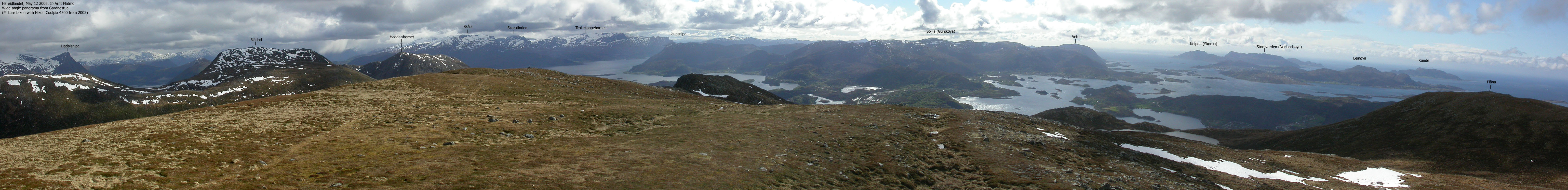
Laupsnipa is located southeast on Gurskøya island, and the Herøy/Sande kommune border runs across the summit. Laupsnipa is one of the more distinct mountains in this coastal region, rising 558m up from Rovdefjorden. The views from the top are just excellent, especially towards the Hareidlandet and Ørsta regions. This is also an excellent viewpoint for viewing the mountains between Dalsfjorden and Syvdsfjorden, with Skoratinden as the most characteristic peak.
The easiest route to Laupsnipa runs from Vålneset. A forest path and a mountain path brings you safely to the summit. This is the route described on this page.
Note that the Laupsnipa high point is located 100m west of the summit cairn. According to Økonomisk Kartverk, the high point (32 V 331586 6901686) is at least 560m, but personal GPS measurements do not support this theory. Awaiting further details, this page uses 558m as the official height.
Laupsnipa (Norge 1:50,000: 558m, Økonomisk Kartverk: 558,??m, UTM 32 V 331682 6901715) has a primary factor of 380m towards the higher parent Storetua (592m). The saddle is located NE of Klipevatnet (approx. UTM 32 V 330447 6903501). Ref. Økonomisk Kartverk (5m contours) the saddle height is in the range 175-180m, interpolated to 178m.
Personal GPS measurements read 561m on top of the summit cairn, and 557m at the high point (on ground). This does not concur with the map and how I perceived the terrain, and thus, the GPS readings are ignored.
Notes: Class ratings are in reference to YDS. Click here for more information.
The trails described below are not necessarily the *easiest* trails to this mountain.
|
Vålneset - Laupsnipa (summer/autumn)
|
|


Access
The nearest larger city is Ålesund. From Ålesund, follow highway E39 towards Bergen, and then RV61 towards Hareid. Take the Sulesund - Hareid ferry and follow RV61 (roughly) 3Km towards Ulsteinvik. At the roundabout junction outside Ulsteinvik, turn left and follow RV61 southbound until you turn right when you see the "Måløy/Åvik" sign. Follow RV61 2,8Km and turn left towards "Måløy/Åvik". Follow RV61 3,4Km and turn left towards "Voldnes". Follow this road 5,4Km until you see the "Laupsnipa" sign on the right-hand side of the road. Find parking nearby.


The route
Follow the forest road up to 130m elev. Stay right in the first two road forks, and turn left on the third. You will see a "T" painted in red at the third fork. The forest (tractor) road turns into a "T" marked forest path. Cross Vålneselva river and follow the ridge all the way to the top. Note that the high point is 100m west of the summit cairn.
 westcoastpeaks.com
Other Møre & Romsdal mountains
Other Norwegian mountains
westcoastpeaks.com
Other Møre & Romsdal mountains
Other Norwegian mountains

