
|

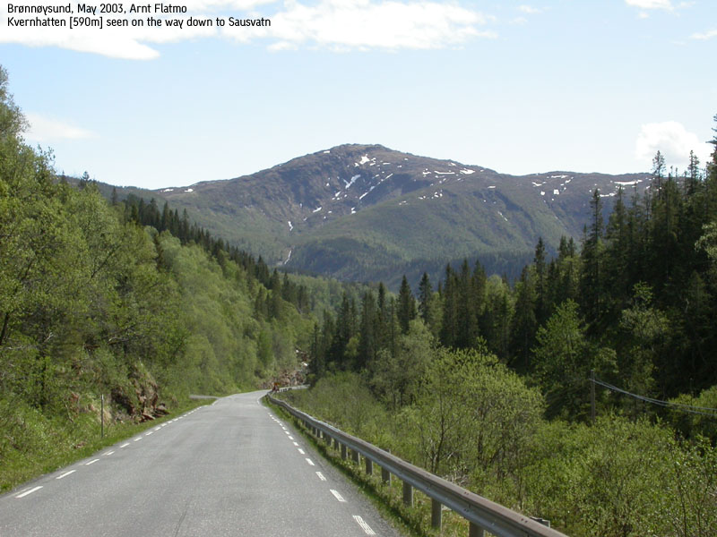
Kvernhatten seen from the road(No Javascript) |
Kvernhatten is one of the lower Velfjorden mountains, located above Lake Sausvatnet. Kvernhatten is from time to time part of "Fjelltrimmen" - 10 mountains that hikers are encouraged to visit during the year, and the route described on this page was properly marked because of "Fjelltrimmen". Throughout the years, the locals have visited Kvernhatten by a number of routes in addition to this one.
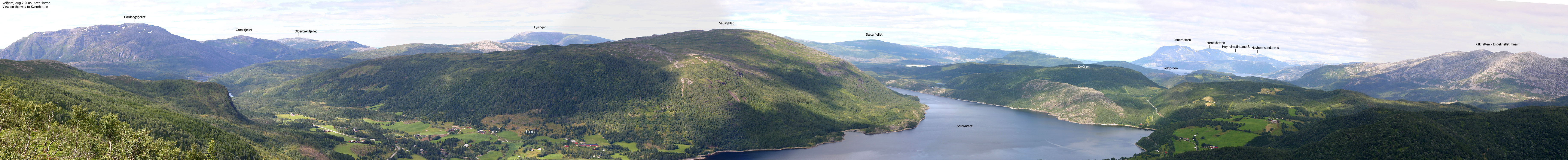
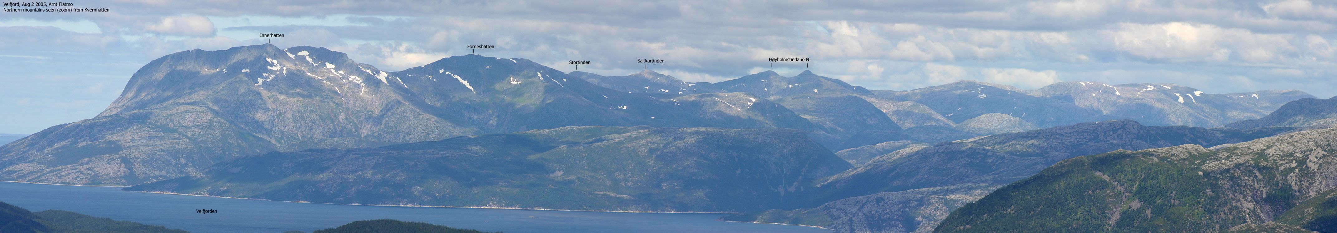
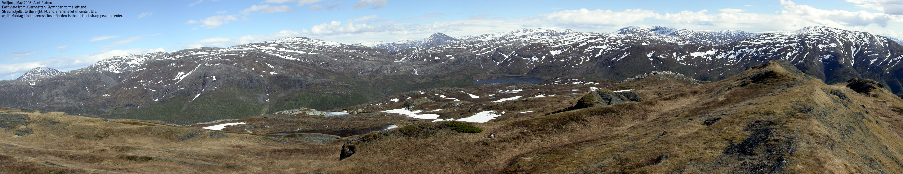
The mountain massif that stretch from Råkfjellet via Engelvikfjellet, Øyrtinden and Snøfjellene block the eastern views, but the coastal view is excellent. Kvernhatten was always popular mountain because of the views and even more so as the trail has been part of "Fjelltrimmen".
Kvernhatten (M711: 590m, Ø.K.: 590,47m) has a primary factor of 327m towards the higher Landfjellklubben (662m). The saddle is found just N of Lake Grunnvatnet. Ref. Økonomisk Kartver (5m contours), you cross the 265m contours on the high route, but not 260m. The saddle height has been interpolated to 263m.
Notes: Class ratings are in reference to YDS. Click here for more information.
The trails described below are not necessarily the *easiest* trails to this mountain.
|
Highway RV76 - Kvernhatten (all seasons)
|
|
From the RV76/RV17 junction at Skillvika outside Brønnøysund, follow highway RV76 for approx. 34Km. Along the way you have passed the places Hommelstø and Sausvatn. The trailhead is found at the end of a long stretch just before the road curves to the right. When Kvernhatten is part of "Fjelltrimmen", the Vassbotnet parking and the trail will be signposted. The parking area is located 50m before the trailhead, on the right-hand side of the road (if you come from Brønnøysund) and has room for 5-6 cars.
If not signposted, the tractor road can be hard to see at first. But it is there, approx. 50m SE of the parking area. The tractor road switchbacks upwards on the south side of Forhatten. Above 130m elevation, the road forks. Go right and follow the road to road end. Continue on forest trail (boggy) and subsequently follow Kvernhatten's northwest ridge all the way to point 486m where the trail turns eastbound and runs directly up to the summit. The ridge route also involves crossing of a meadow that gets quite boggy after rain. Descend your ascent route. Landowners disapprove of hikers during the autumn moose hunting season.
|
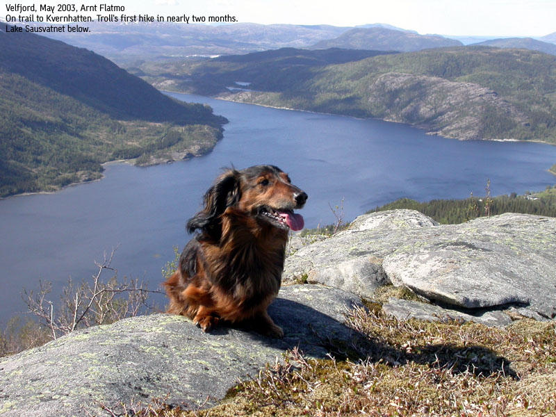
My August vacation had begun and while I would go off hiking and climbing cool mountains, my dog "Troll" would spend the month up here in the north with my mom. I had a great week up here, visiting lots of nice mountains. Due to a seriously nice party with friends the night before, I didn't feel for going anywhere else but to our local mountain Kvernhatten. I brought along my dog. In a sentimental mood, I invited the dog to come along for our last hike before I headed out on my August adventures. My dog is obviously not of the sentimental kind and responded with an "absolute" sit-down at the beginning of the trail. Troll entered the backpack 11:25AM, where he remained until we reached the summit 1 hour later. We were not the best of friends by then, and while Troll (well realizing this) tried to become invisible next to the summit cairn, I sat down and reflected on the events taking place here nearly two years ago. My dad (born 1938) grew up here and from his kitchen window, he could see directly up to the Kvernhatten summit. This was "his mountain", throughout his lifetime. After a series of cardiovascular accidents during the 1990's, a number of muscles were partly paralysed. He could walk, but had to drag his foot along the way. Apparently, he wanted to visit "his mountain" one last time, but had problems finding people who wanted to come along. Quite naturally, given his condition. So what do you do? One autumn day in 2003, he set off on his own and phoned us from the top of the mountain. Proud from top to bottom. He nearly made it all the way down, but a massive cardiac arrest forced him to give up. By this time, we had called friends who formed a search party. It had turned dark, but it didn't take long before they found him. Our friends kept him company until the ambulance arrived. He never regained consciousness and passed away at the hospital. Everyone knew how much he wanted to reach this top, one last time. In my mind, I believe this has to be the best of endings. These were some of my thoughts when I left Kvernhatten this nice autumn day. Troll followed willingly along, knowing there would only be downhill from now on.
|


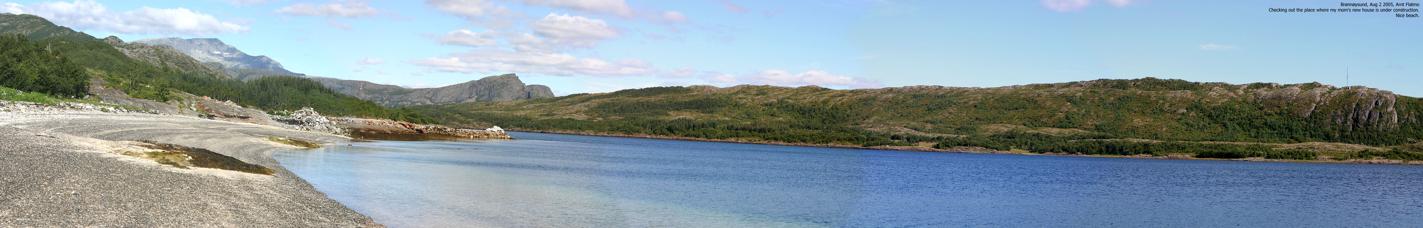
Pictures from later in the day, visting the place in Brønnøysund where my mom's new house is being built.


No Javascript:
1 2 3 4 5 6 7 8 9 10 11 12 13 14 15 16 17
|
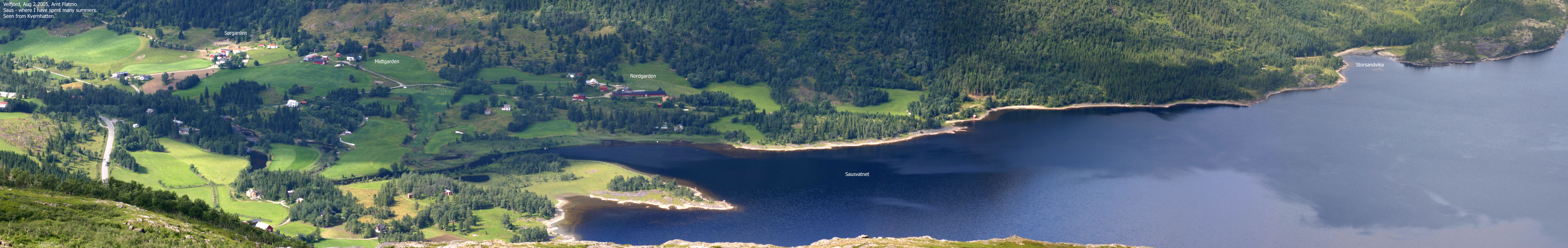
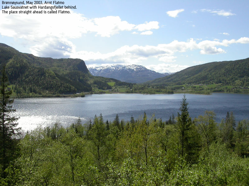
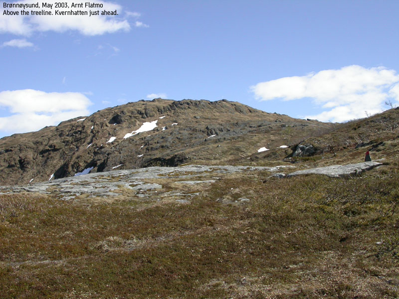
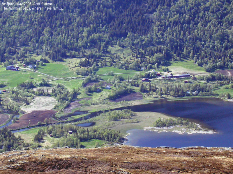
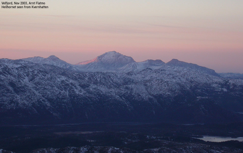
I was on a quick visit in Velfjorden, located east of Brønnøysund in Nordland Fylke. This is where I lived from age 2 to 6, and where I have spent at least 25 great summers and other vacations. The purpose of the trip was to bring the dog back to "reality". He had spent nearly two months in great tranquility up here, and I was wondering what kind of shape he was in. I had decided to take him on a hike to Kvernhatten the same day, and get my answers there. It was forecasted rain in the afternoon, but the weather was gorgeous. The trailhead was only a couple of kilometres from our place, and there was a "Fjelltrimmen" parking sign along the road. Very convenient. The forest road started only a few yards from the parking. Already in the steep forest road, I could see that Troll was not quite sure if this was how he wanted to spend the afternoon. It was clearly warm, and his tongue was touching ground. At the place where the forest road forks (the trail follows the right fork), Troll decided to take a rest for an infinite period of time. I had no backpack, and carried him in my arms for 5 minutes. The pause did him good, and he kept a good pace up the trail in the pine forest. The trailbreakers had done a good job. The trail was easy to follow, and red "T" markings appeared everywhere. Out of the pine forest, we crossed a small meadow that is guaranteed to be soaking wet after rain, before we started to head up a long ridge in a birch forest. The ground was moss, and Troll's strength quickly vanished. I carried him halfway up the ridge, until the Moss got harder. Now that Troll had the summit in view, he found the motivation to finish the hike in style. We both welcomed the stream just below the summit, as one gets thirsty up here, on a warm day. The views from above the birch forest gave promise of greater views from the summit. And I was not disappointed. A chilly wind cooled us both down, and I layed down flat on the summit, just enjoying life. It took us 1h:5m to the top. Troll was running in circles, looking for his regular summit lunch box, but there was none. Troll uttered serious disappointment. I took a lot of photos on top, especially towards Heilhornet, which I am about to hike later in 2003. This was clearly a popular mountain. I signed in the guestbook as #10 that day, and more hikers were on the way up the mountain. After 25 minutes on top, we headed down, and Troll showed no sign of a two-month rest. A wonderful afternoon hike, recommended to anyone who is driving from Brønnøysund towards highway E6.
|
Move cursor to read notes, and click on the images to see full version.
Some of the thumbnails may have been cropped to fit the format.
Pictures are presented in the order they were taken.


No Javascript:
1 2 3 4 5 6 7 8 9 10 11 12 13 14
Other pictures from the car:


No Javascript:
Pictures from the Nov 29 2003 hike:


No Javascript:
 Other hordaland mountains
Other Norwegian mountains
westcoastpeaks.com
Other hordaland mountains
Other Norwegian mountains
westcoastpeaks.com

