
|

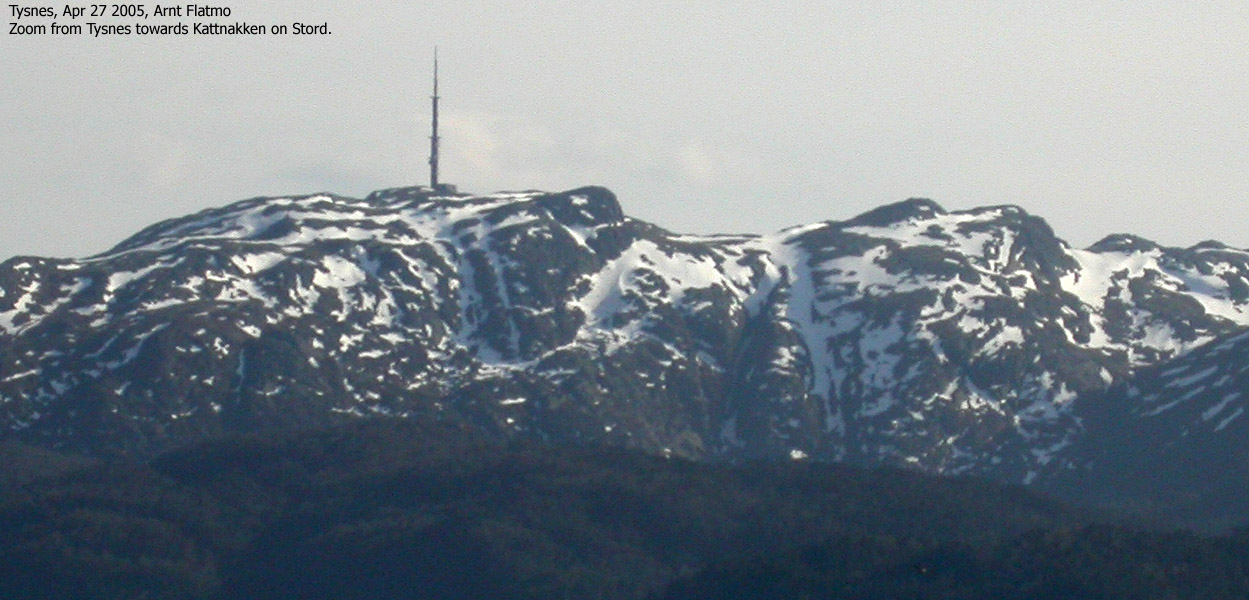
Kattnakken seen from Mehammarsåta(No Javascript) |
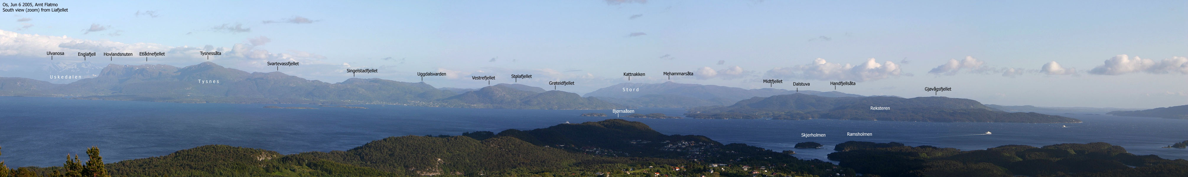
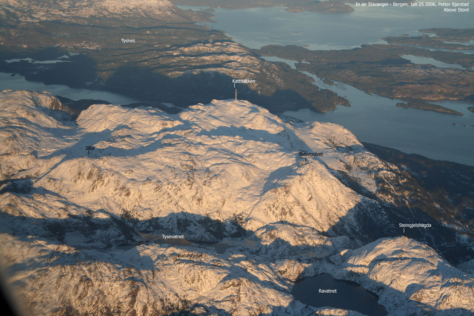
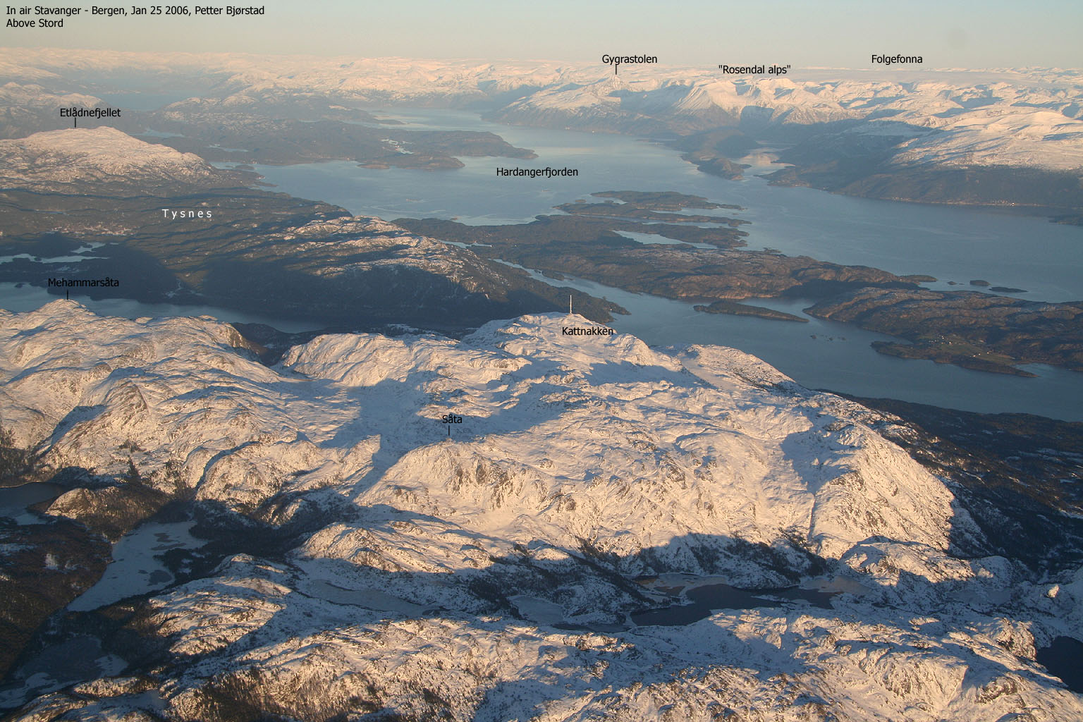
Mehammarsåta (749m) is the dominating mountain on the island of Stord. This peak is the highest point on a large mountain plateau on the island. Kattnakken is the second highest point on this plateau (and on the island), but would have been much less significant if it hadn't been for the large TV mast located next to the summit. Stovegolvet marks the southern end of this massif, and falls steep down to the south and south-west. Stovegolvet is an unusual name for a mountain. In English this would translate to "Living room floor", and probably reflects the flat concrete foundation below the Storegolvet building.
Further south and south-west of this plateau, you will find a number of smaller humps, falling completely in the shadow of the larger plateau. The humps with enough independence to qualify as separate mountains are Steingilshøgda (529m), Budalsfjellet (526m) and Klovfjellet (518m). Note that Budalsfjellet has no name on the M711 map, only the 526m and 511m points. Steingilshøgda is also known as Steingjelshædda.
A good trail system has been developed on Stord. The mountain plateau resembles Byfjellene in Bergen, with respect to the terrain and number of marked trails. The Stord citiziens should be proud of this beautiful terrain just outside their doorstep. The views are enormous in all directions. One has an unobscured view towards Folgefonna, the Rosendal and Uskedalen mountains, which are the mountains that will immediately attract your attention.
On this page you will find a route that will take you over all the mountains mentioned above, except Mehammarsåta, which is described on a separate page. Half of the hike is off-trail, while the route up to Stovegolvet and towards Kattnakken follows the trail system.
Kattnakken has a primary factor of 206m towards the higher Mehammarsåta. The saddle is near lake Stemmetjørna. The last adjacent 5m contours (Norgesglasset 5m detail map) are 520m. The saddle height is interpolated to 518m.
Stovegolvet has a primary factor of 45m towards the higher Skorafjelle. The saddle is found between these two tops. The last adjacent 5m contours (Norgesglasset 5m detail map) are 660m. The saddle height is interpolated to 658m.
Steingilshøgda has a primary factor of 176m towards the higher Såta. The saddle is just N of lake Ravatnet and the high route runs across Budalsfjellet before it turns eastbound by point 426m. The last adjacent 5m contours (Norgesglasset 5m detail map) are 355m. The saddle height is interpolated to 353m.
Budalsfjellet has a primary factor of 158m towards the higher Såta. The saddle is just N of lake 361m. The last adjacent 5m contours (Norgesglasset 5m detail map) are 370m. The saddle height is interpolated to 368m.
Klovfjellet has a primary factor of 155m towards the higher Budalsfjellet. The saddle is just W of lake Ravatnet. The last adjacent 5m contours (Norgesglasset 5m detail map) are 365m. The saddle height is interpolated to 363m.
Note: Class ratings are in reference to YDS (Yosemite Decimal System).
Note: The trail described below is not necessarily the easiest trail to this mountain.
|
Power plant - All summits (summer/autumn)
|
|
Access
From Bergen, follow highway E39 southbound. From Halhjem (outside Osøyro), take the ferry to Sandvikvåg. The ferry takes about one hour, and the fare is NOK 159,- for passenger cars (1 person) per Nov 2003. From Sandvikvåg, follow E39 southbound towards Leirvik/Stavanger. Approx. 20,8Km after you leave the ferry, exit right towards "Lundseter 5".
Follow this road upwards. After 1,5Km, the road makes a sharp right turn. This turn is marked "Lundseter". After 4,8Km (from where you left highway E39) you see a Y junction. You will be coming down the gravel road to the right. Go left in the Y junction and continue 400m towards a power plant. Park here.
The route
Steingilshøgda
The main hiking trail runs from behind the power plant. Instead of following this trail, follow the gravel road that curves upwards (400m after the Y junction described above). Follow this road towards the dam from lake 318m (height not given on M711 map). As you pass a building on your right (just before the dam), notice a trail that goes off to the left. Follow this trail upwards until it descends. Then leave the trail and go off-trail in a southbound direction. You will need to switchback up and down to avoid obstacles in the terrain. The off-trail route to the summit is class 2. The summit consists of a cairn and an antenna for cellular network.
Klovfjellet
A cairned trail will take you halfway (south-west) across the Steingilshøgda plateau before you will have to go off-trail in order to reach the south end of lake Ravatnet. Follow the ridge that leads to the dam. When you reach a cliff, either go down a convenient crack in the cliff, or seek left to bypass the cliffs. Below the cliffs, go right when you face a hump that is higher than where you are. Walk around this hump. When you reach the lake, either cross below the dam or earn extra credit for climbing directly onto the dam. The Vatnadalen forest road runs all the way to this dam, and a trail runs on the W side of lake Ravatnet.
You will not be following any of these trails. Instead, climb directly (south-west) up the Klovfjellet hillside. In this hillside, you can follow some boulderfields that will provide a variation from grass and turf. Klovfjellet consists of two equal heigth points, both marked with modest cairns. It is impossible to tell which is the highest. According to the map, the northernmost of these two points is the highest - 518m. The route from Steingilshøgda to Klovfjellet is class 2.
Budalsfjellet
This name is not found on the M711 map. A hunter told me that points 526m and 511m are known as Budalsfjellet. As lake Budalsvatnet is just south of this mountain, this may very well be so. In a north-east direction, follow the main Klovfjellet ridge towards Budalsfjellet. Aim directly for the saddle. Cliffs dominate above the saddle, and you need to find a steep gully that takes you safely down. Down below, you can see the "Kløvbu" cabin. Once down the first gully, climb over the fence on the right hand side. Then go left and find a route that takes you down to the trail that runs along lake Budalsvatnet. Some bushfighting is involved in order to reach the trail. The gully takes the route from class 2 to class 2+.
From the cabin, walk only a few meters towards lake Budalsvatnet and locate a vague path that climbs northbound to Budalsfjellet. The general is direction is northbound all the way to the summit. A distinct cairn marks the summit. The view towards Stovegolvet is great. Study the ridge you will be going up next.
Stovegolvet
Now you need to get down to the trail by lake Tysevatnet. The fastest way is to head south-east towards a distinct hump, and then go down left in a jungle of juniper bush. You need to show caution if you take this way. Alternatively, follow your ascent route back to the cabin and follow the trail from there. You're now on a "T" marked trail that follows the south shore of lake Tysevatnet. You cross the dam before the trail begins to descend towards the small lake 318m.
The following is a bit tricky. You need to get on a trail that was running parallel to the forest road you were following in the beginning. The only connection between these two trails is halfway below lake Tysevatnet and lake 318m. It is hard to see in the beginning. Look for faint "T" marks on the rock up to your left. The trail climbs upwards, then follows boggy terrain before it descends. Follow the trail downwards until you see the trail fork. Then follow the other trail up again.
When you reach a yellow information sign ("don't pollute the ground"), then follow a trail that runs up to your right. Follow this "T" trail all the way to Stovegolvet summit. This is in general a class 1 trail, but a section where you need to use a fixed rope to avoid scrambling, makes this a class 2+ trail. It is very seldom a "T" trail reaches class 2+ grade. After all this hiking, and the strenuous ascent towards Stovegolvet, a surprise awaits you near the top. The summit isn't so close as you thought. You actually have to descend some before taking on the final hill. But soon, you can step onto the Stovegolvet summit, which has a large cairn denoting the summit.
Kattnakken
You're on the main mountain plateau now, and there is a myriad of trails up here. Set a north-east direction towards Kattnakken, and follow the main ridge down from Stovegolvet. "T" trails will take you to where a stream runs directly down to Heia. A trail runs directly down to Heia from here. Follow a lesser path across the streams (still north-east direction) towards Kattnakken. The 724m point is just next to the TV mast. Follow the gravel road down to the Y junction mentioned in the Access chapter. Then turn right and head back the 400m to the car.

It was high time I did some more peaks on Stord. It had been over three years since I visited Kattnakken, and still I hadn't made a web page for the mountain. I also noticed the great opportunity of getting a bag of mountains in one hike. Just needed a week-end day free of rain. This Saturday was cloudy, but apparently, no rain was expected. On my way to Stord, I had this feeling I would get sunshine during the day. Don't know why. Just had the feeling. As I drove towards Leirvik, I reminisced the crazy hike to Mehammarsåta and Tysnessåta in April 2003. Totally insane. I was smiling as I passed the Børtveit trailhead.
As I had hiked Kattnakken from Heia back in Apr. 2000, I knew the area. Instead of driving up to Heia, I decided to follow the road until it ended, and play it by the ear from there. I left the trailhead 10:42AM. Troll looked utterly confused when I tried to get him going up the forest road. It's the same old thing. First he looks a different way, as he didn't hear me. On my next command he sits down. On my third command he lays down. On my fourth command he shows his teeth. This is level 4 and means backpack time. Level 5, the highest, means he runs back to the car. That has only happened once before, on Spiterstulen, after realizing that I wanted him to walk up to Galdhøpiggen.
Steingilshøgda and Klovfjellet
With a heavier load than planned, I was heading up to Steingilshøgda. Going off-trail in these mountains after rain called for some caution. The rock was extremely slippery. I had brought my ice-axe which I repeatedly made good use of, even if there was not an inch of snow on the entire island. But for advancing up cliffs, it gave me a welcome grip so I could drag myself onto the next ledge. I reached Steingilshøgda summit 11:30PM after a 320m vertical ascent. From here, I got a good view of the rest of the route. At this point I had no idea on how strenuous the day would be. Troll complained about the lack of lunch from his backpack position. He knows a summit when he sees one. I replied with a well founded "Grrr" and he shut up.
The hike up to Klovfjellet didn't offer much problems. The terrain clearly demanded some route-finding, but the routes were quite obvious. The hardest part was to climb onto the Ravatnet dam, although this was not necessary. I could have crossed the stream below. After a slightly rough ascent up to Klovfjellet, I reached the summit 12:44PM after having visited both high points. Troll made further sounds from the backpack, but it was not lunch time yet. He had actually done some walking on the way to lake Ravatnet, but nothing that would qualify for a meal just yet.
Budalsfjellet
While heading towards Budalsfjellet, I studied the ridge leading to Stovegolvet. I saw vaguely a trail in the lower section, and told myself I would be climbing up this ridge even if this was not the public trail. The trail to Stovegolvet did not show on my M711 map, so I had no idea where the trail was. As I reached the NE end of the Klovfjellet plateau, I couldn't figure out how to get down to the saddle. But after looking around, I found a steep gully that offered a safe route down. Again, the axe came in handy, but this time to get an anchor in the slippery grass. Half-way down, I had to cross a fence. Then I took the wrong route towards the cabin further down. I ended up in a spooky place where I spent at least 10 minutes figuring out how to get myself and the dog safely down. Finally I gave up and headed up again. Then I found a parallel route which was too damned easy. But eventually, I joined the trail near lake Budalsvatnet.
On the way to Budalsfjellet I followed an extremely vague trail, which I lost numerous times. Fortunately, the pathmakers and I had the same idea on where the route should run, so after losing the trail, I would find it again a minute later. At 13:57PM, we reached Budalsfjellet summit, and it was time for lunch. Sunshine came along, and the day was just getting great. Suddenly I started to worry about the time. Although I had been to Kattnakken before, I still wanted to visit this summit again. This time via the trail up to Stovegolvet. I tried to calculate how long it would take, and the plan was to be back at the car by 18:00PM. At this point, I forgot that it would be dark already by 17:30PM.
Stovegolvet and Kattnakken
Due the time pressure, I took the short way down from Budalsfjellet. Hiking in the juniper tree jungle was far from safe. A fall down a small cliff was a bit painful, but inconsequential. After crossing the dam at lake Tysevatnet, I found the trail that would connect with the Stovegolvet trail, but gave on it when it started to descend. I went off-trail, hiked up a ridge and found the trail higher up. An effort to get the dog climb the trail failed. I was in for a hard walk up the long hillside. I then came to the spot where a fixed rope was put in place. I made no efforts of bypassing this rope. The rock was way too slippery. Higher up, I had to take several short breaks and realized I had to get a lighter backpack. I took the dog out, looked him deep into his eyes, and told him quietly, yet firmly - Walk! He walked. We reached Stovegolvet 15:45PM and the red evening glow painted a pretty picture on the mountain plateau ahead of us.
The "T" trail towards Kattnakken was a but cumbersome for a small dog, and I decided to carry him to save precious time. I was walking at full speed and reached Kattnakken 16:36PM. I headed immediately down the road from Kattnakken. Just before Heia I met a guy walking the dog. The time was now 17:00PM and it was getting darker by the minute. He offered me a ride back to my trailhead, which I gladly accepted. 17:15PM I was back at the car, and now it was getting seriously dark in the forest. I caught the 19:00PM ferry from Sandvikvåg and was back at the house 20:35PM, 12 hours after leaving it.
Move cursor to read notes, and click on the images to see full version.
Some of the thumbnails may have been cropped to fit the format.
Pictures are presented in the order they were taken.


No Javascript:
1 2 3 4 5 6 7 8 9 10 11 12 13 14 15 16 17 18 19 20 21 22 23 24 25 26 27 28 29 30 31 32 33


No Javascript:
 Other hordaland mountains
Other mountains in this area
westcoastpeaks.com
Other hordaland mountains
Other mountains in this area
westcoastpeaks.com

