
|


Skarven is one of the most popular skiing mountains in the Åndalsnes region. Although Skarven does not offer the same number of descending meters as Kyrkjetaket and Kjøvskartinden, access is convenient, and you still get a good run. Skarven is located above Skorgedalen valley, and the trailhead is the same as for Rauma Skisenter. Check their web-site for information about when the road opens in winter.
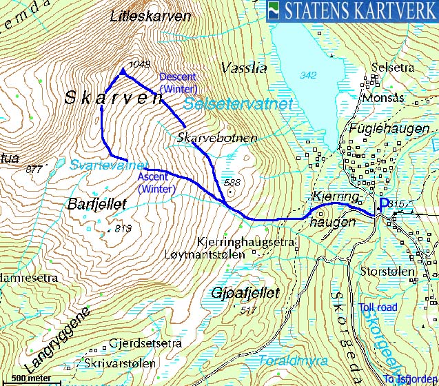
Those who come to Skarven for Telemark skiing, would typically ascend via the southwest ridge, and descend directly into Skarvebotnen. There is however nothing wrong with ascending from Skarvebotnen, which is the shortest route to the top. The route via the southwest ridge will also give you a fine (less steep) run back to the trailhead.
As from most tops in Møre og Romsdal, the views will not disappoint you. Skarven is somewhat more "independent" than the average Rauma top, as deep valleys "isolate" Skarven from the massive mountain region north of Isfjorden/Åndalsnes - the "haven" for all spectacular mountaineering in Rauma kommune.


Skarven (Norge 1:50,000: 1048m, Økonomisk Kartverk: 1048,21m, UTM 32 V 428226 6942634) has a primary factor of 661m, towards the higher parent Tarløysa (1086m). The saddle (approx. UTM 32 V 428066 6944232) is found northwest of Tverrberget, between the two mountains. Ref. Økonomisk Kartverk (5m contours), the saddle is defined as a fixed point - 387m.


Google's interactive map. You can zoom, pan and click on the markers.
Notes: Class ratings are in reference to YDS. Click here for more information.
The trails described below are not necessarily the *easiest* trails to this mountain.
|
Skorgedalen - Skarven (winter)
|
|
Access
(All distances are approx.)
From the city of Åndalsnes, follow highway RV64 (Molde) eastbound along Isfjorden. The road curves around the Isfjorden bay, and heads westbound. Near Uraneset, 14,5Km from the south side of Nebbetunnelen in Åndalsnes, turn right when you see the "Skorgedalen Skisenter" sign.
After 500-600m, turn left towards "Rauma Skisenter". Pay toll at the entrance of the road (on busy week-ends, they may collect the fee) and drive up the Skorgedalen parking area (3,3Km)
The route
From the Skorgedalen parking area, look west, and you will see the Kjerringhaugen hill with cabins on top. Pass this hill to your right (north), head west for the river from Barfjellet (you don't see it, but expect tracks) and stay on the north side until you everything gets obvious. Eventually, you gain the southwest ridge (never narrow) and proceed to the top.
For descent, enjoy skiing down into the Skarvebotnen basin, and then aim for your ascent route up from the trailhead. You have all sorts of options, which you will get familiar with, upon ascent.


 westcoastpeaks.com
Other Møre & Romsdal mountains
Other Norwegian mountains
westcoastpeaks.com
Other Møre & Romsdal mountains
Other Norwegian mountains

