
|

Haafjellet seen from Utåke |
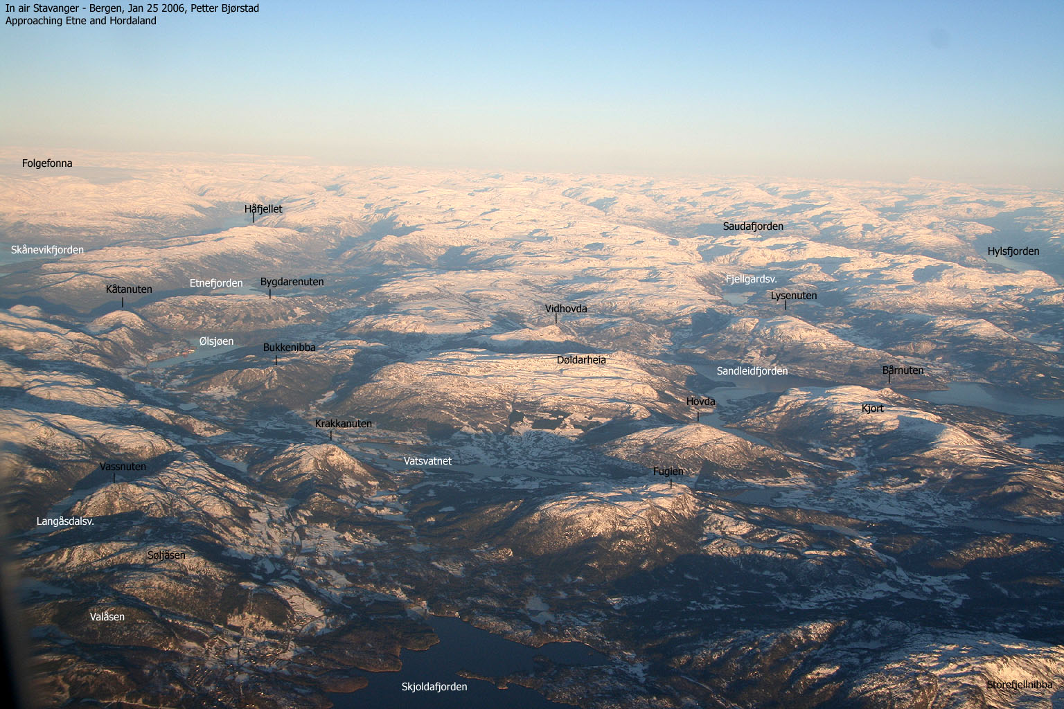
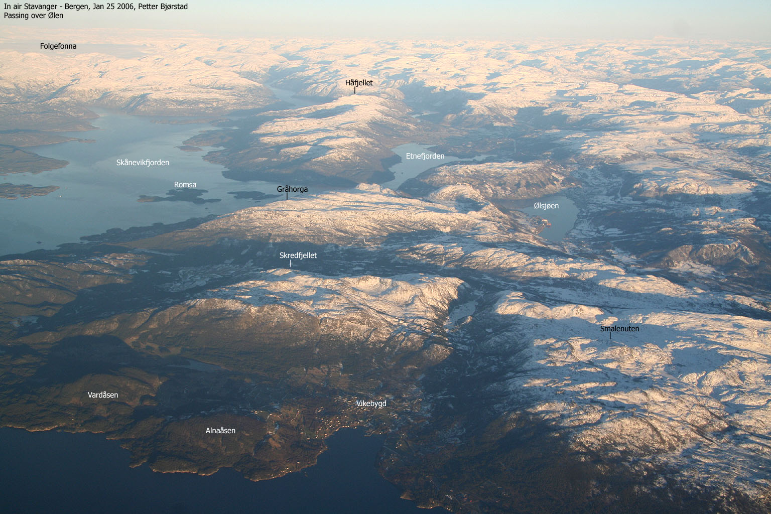
Håfjellet dominates a long ridge of mountains south of Skånevikfjorden and Åkrafjorden, and can be seen across the fjord when taking the ferry from Utåke to Skånevik. The mountain can be reached from the east or west. The north and south slopes of the mountain fall steep to Åkrafjorden (north) and lake Stordalsvatnet (south).
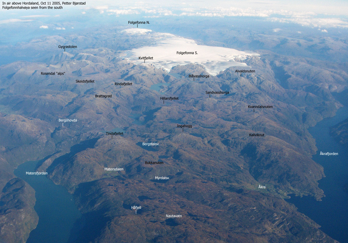
The views are splendid. A string of high Etne mountains dominates the south and east views. Towards the north, the view is dominated by the Ulvanosa massif (Uskedalen), the rugged and wild mountains near Rosendal and the Folgefonna glacier.
Hovlandsskuten is the 2nd highest mountain on this ridge, and is located SW of Håfjellet. The views from the mountain are about the same as from Håfjellet, except that the NW views are obscured by Håfjellet. The mountain connects to Håfjellet via an easy traveled saddle, and a easy route up between some large cliffs.
Primary Factor
Håfjellet has a primary factor of 759m towards the higher Etne mountains in the east. The saddle is approx. 178m. The adjacent 5m contour lines (Norgesglasset) are 180m. This ranks Håfjellet as #8 in Hordaland, when ranked by primary factor.
Hovlandsskuten has a primary factor of 136m towards the higher Håfjellet. The saddle is at Norheimskar and the height of the saddle is approx. 643m. The adjacent 5m contour lines are (Norgesglasset) are 645m.
Note: Class ratings are in reference to YDS (Yosemite Decimal System).
|
Hustufta - Håfjellet - Hovlandskuten & back (summer/autumn)
|
|
Access
To Hustufta
From Bergen, your destination is Hustufta farm near Håland. There are several ways to get there. In any way, you will need to cross the Hardangerfjord. This can be done at several locations, but the Gjermundshamn- Løfallstrand ferry is used as example on this page.
From Bergen, follow highway E16 towards Oslo. Exit onto highway RV7 at the Trengereid junction. The Trengereid junction is approx. 9,2 from the beginning of the Arnanipa tunnel, which you need to pass when coming from Bergen (unless you take the Os-Venjaneset ferry). Follow highway RV7 for 14Km and exit right onto highway RV48 (Tysse). Follow this road to the RV552 junction at Eikelandsosen for approx. 25,1Km. Continue towards the Mundheim junction for 16,5Km and exit right onto highway RV49 towards Gjermundshamn. The road from Mundheim to Gjermundshamn is approx. 12,7Km.
Take the Gjermundshamn-Løfallstrand ferry, and turn right towards Rosendal. Drive this road for approx. 46,5Km until you reach Utåke. Take the Utåke-Skånevik ferry. Go left after the ferry, and follow this road for approx. 11,9Km. Exit right onto a gravel road that runs by a few houses and farms. Follow this road for 600m to Hustufta. Either park by the highway or ask for permission to park on the Hustufta farm.
Different route back to Løfallstrand
If you want to vary the route, then go right on the highway (coming from Hustufta). Continue 1Km to a junction and go left. You're now on E134 towards Røldal/ Odda/Haukelisæter. Follow this road for approx. 40,5Km and turn left towards Odda. Continue this road for approx. 17,6Km to the highway RV13/RV48 junction in Odda. Go left towards Rosendal. Drive approx. 2,9Km and go left in the roundabout (Rosendal). Drive approx. 37,3Km to the ferry at Løfallstrand and go back the same way you came.
From Odda, you can also drive to Kinsarvik or Utne, and take the ferry to Kvanndal, and return to Bergen via Voss or Norheimsund.
The route
Håfjellet
Follow a small forest road from the Hustufta farm which will cross the field, going towards the left. Cross the fence via a gate and locate a vague path going upwards. Seek gradually left and you will connect to a trail coming from Neset. The trail will take you to the left of the ridge, and eventually give you a view towards Lake Stordalsvatnet. The path continues upwards but curves around the ridge, so you are actually in the slopes towards the lake. Continue up through the forest, and you will see a long cliff wall (rock face) to your right. The trail takes you to a boulderfield. Go right, towards the wall, and follow the trail that runs up by the wall.
The trail tops out on a meadow, and continues up to your left. The trail will curve around a distinct hill above you. On top of this hill, you are on a ridge with views on both sides. Next, you will arrive at the first "Håfjellet" trailsign. On the left-hand side are the ruins of an old stone cabin (Nesestølen). Continue on the path which runs upwards, slightly left. You will meet a small valley coming up from your left. In this valley, you will see the 2nd trailsign. Follow the valley which leads you to the pass between Dalanuten and Håfjellet. Here you will find trailsign #3.
The final part to Håfjellet (left) is much steeper than the route so far, but the walk up should be easy. When you get on the plateau, move towards the north and the summit. There you will find a large cairn and (perhaps) the visitor's register.
Hovlandsskuten
If you have the will to continue, then move towards the west end of the large summit plateau. Seek towards the left, and you will find a route down with a cliffband to your right. This route will take you down to a path that will take you towards the saddle between the two mountains. The direction should be obvious.
When you reach the cliffs that you must pass in order to get to the saddle, then seek far left (towards lake Stordalsvatnet), without loosing any significant elevation. A small stream falls down to the next level. If you find this stream, then a gully just to the left will take you down one level. When down one level, go right, pass the same stream and locate a tiny opening in the second cliffband. It's big enough to walk in, and this opening will take you down one level. From this level, the route to the saddle is obvious.
From the saddle, pass a series of humps on your way to the summit, which is a bit further away. If you have clear weather, there is no mistake about the summit, marked by a few rocks (tiny cairn).
|
My friend Petter had visited this mountain Apr 5th, on the conquest for the top 10 mountains in Hordaland with largest primary factor. He had some great pictures to show for his trip, and I decided that it was time I visited this area as well. In his trip report, he made some comments about the lengthy drive to this mountain. I got to experience this as well. I left Bergen 06:50AM and caught the 08:20 ferry to Løfallstrand. There was absolutely no connection with the Utåke-Skånevik ferry, and I had to wait 40 minutes at Utåke. I drove to the same farm as Petter used as the trailhead, and was granted permission to park on the farm. 11:30AM, I was on my way. I had some problems finding a proper trail, but I remembered from his trip report that left was good. By seeking towards the left, I found a good trail that I followed all the way to the snowline. The trail was easy traveled and I had a quick pace up the mountain. At the snowline, near the pass between Håfjellet and Dalanuten, there were tracks from deer and humans, crossing in any direction. But the route to the mountain was obvious. Straight up! I reached the summit 12:45PM and signed the guestbook. There had been 4 visitors since Petter was here. One woman had been here three days in a row, and then some other guy. As the hike had been so short, I decided to go for Hovlandsskuten, further SW. I left the summit 13:00PM and headed towards the saddle. Above the saddle, I ran into some complex cliff formations, and from above, it wasn't easy to determine the best route down. I started to descend, and performed a small technical move (both hands and both feet) to advance to a ledge that looked to be a gateway to the next level. It did, and I prayed that I would see a better route from below. Passing the next cliff level was far easier, and I could then begin the long walk up the ridge towards the summit. There were all sorts of ups and downs on this route. I reached the Hovlandsskuten summit at 14:05PM. I checked the map, and confirmed that there were no higher mountains further on the ridge. The next summit, Stølehetta was 5 meters lower, and had less than 100m primary factor towards the summit I was on. It was time to go home. I left the summit 14:10PM and from the saddle, I assumed I had found a better route up. From being a scrambler's route, the route was now degraded to class 1. It was an easy all the way back to the Håfjellet summit, which I reached 15:15PM. From the summit, I noticed a forest fire on the other side of the fjord, near Matre. I called the fire dept., but the fire had already been reported. This fire made it to the TV news later in the evening. I was making good progress on the way down, until I started looking for a good place to photograph lake Stordalsvatnet. After taking pictures, I followed the trail that appeared before my feet, and after 5 minutes, I concluded that I was going in the wrong direction. It was fairly easy to understand that I was heading towards Neset, but I didn't bother climbing up again. I followed this trail all the way down to the highway. This route involved a fairly complex crossing of a high and sharp wired fence. I climbed up on a rock, placed on foot on the top of the wired fence, and jumped. Unfortunately, my ice axe on the backpack got tangled up in the fence. The landing was quite sudden and brutal. And I had to remove the backpack before I could get disconnect from the fence. From the highway, I found a old tractor road that was heading towards Hustufta. This saved me from at least 1Km on the road. Due to the bad navigation, the hike down took 30 minutes longer than strictly necessary, and I arrived the car at 16:45PM. I decided to take another route back home, and drove along Åkrafjorden towards Odda. I had never driven this road before, and found the drive quite enjoyable. I also noticed that the forest fire had increased. Another, smaller, fire had started further east on the mountain. It has been a very hot period. From Odda, I took the tunnel under the Folgefonna glacier, and arrived Løfallstrand 18:15PM. The next ferry was leaving 19:20PM. Sigh... I was back at the house in Bergen at 21:15PM. A good hike, but a long day in the car.
|
Move cursor to read notes, and click on the images to see full version.
Some of the thumbnails may have been cropped to fit the format.


No Javascript:


