
|


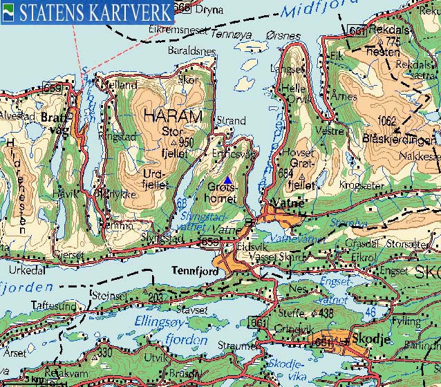
Grøtshornet is located above the place Vatne, with Storfjellet as a close neighbour to the west and the Grødet-Otrefjellet-Blåskjerdingen massif to the east.
The mountain can be reached on forest road + path from (just outside) Vatne and was per Jan. 2006, part of "Fjelltrimmen, I.L. Ravn". "Fjelltrimmen" is a common name of a fixed number of tops/points that people attempt to visit during one season. The sporting assocations who organise these activities also maintain and mark the paths up to the tops on the list, and I.L Ravn (IdrettsLag - sporting assoc.) has prepared a good route from Eide up to the top of Grøtshornet.
Another route runs up the north ridge. This route has also been part of "Fjelltrimmen" in the past. Per May 2006, the path indicated that it was no longer frequently traveled, and the red "F" paint on rocks had begun to fade. Normally, the Fjelltrimmen organisers (throughout the country) alternate between paths on popular mountains. It is therefore likely to assume that the north ridge route will be "refreshed" at some later point in time.
The mountain range that spans Gamlemsveten, Tverrfjellet, Hildrehesten, Storfjellet, Grøtshornet, Grødet and Blåskjerdingen offers excellent views from all the tops. Blåskjerdingen and Storfjellet are the primary viewpoints, but from all of these tops, you have a front-row seat towards the "Sunnmøre alps", with Romsdal and Tafjord mountains further in the background.
Grøtshornet (M711: 663m Ø.K.: 662,96m, UTM 32 V 375874 6939976) has a primary factor of 581m towards the higher parent mountain Storfjellet (950m) The defining saddle (approx. UTM 32 V 374641 6941441) is found just north of Lake Fannevatnet between Storfjellet and Grøtshornet. The lake drains south and 300m further north, a stream from Storfjellet drains north. The saddle is found between the stream and the lake. Ref. Økonomisk Kartverk (5m contours), the saddle is given as a fixed point; 81,5m --> 82m.
Notes: Class ratings are in reference to YDS. Click here for more information.
The trails described below are not necessarily the *easiest* trails to this mountain.
|
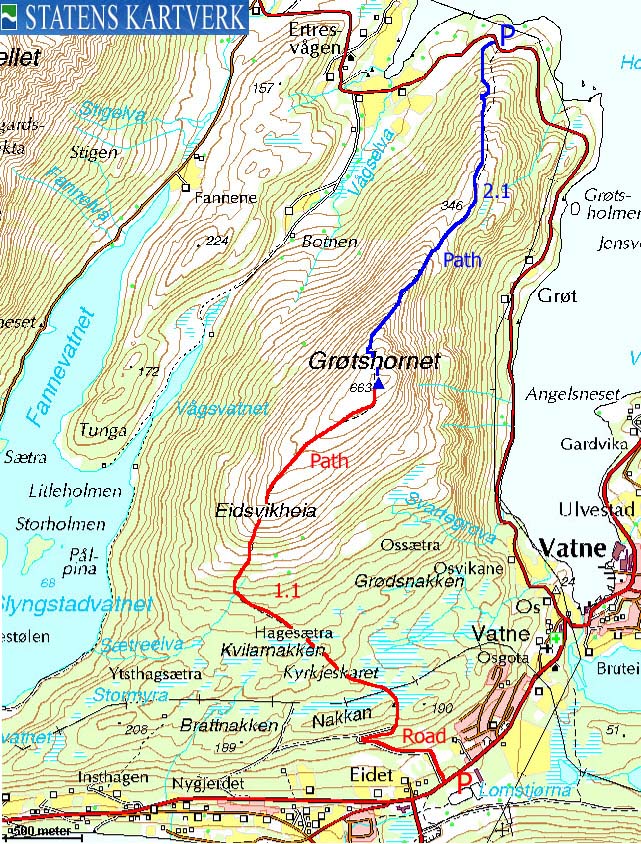
Route 1.1: Eidet - Grøtshornet (summer/autumn)
|
|
Access
From Ålesund, follow highway E136->E39 towards Åndalsnes. From the E136/E39/Olsvika roundabout near Breivka, follow E39 approx. 13,3Km. Turn left onto highway RV661 (Skodje/Brattvåg/Vatne). After 1,5Km, pay toll at an unmanned toll booth (coins + credit cards + AutoPass). Approx. 9,7Km after you left E39, you reach the RV659 (Brattvåg)/661(Vatne) junction. Turn right here. After 200m, you see a forest road on your left-hand side (signed "Grøthornet"). This is your route. Proceed 150m and find parking at the Ravn Stadion. A trail map is posted where you park.
The route
Follow the main road towards the forest road. Continue upwards 730m (distance) until you run into a road fork (Kyrkjeskardet/Sætreskardet). Turn right, proceed 130m and turn left onto a forest path marked by poles with red paint.
The path runs northbound until you are standing below a powerline. From here, the direction is northeast, across wetlands, aiming for the Grøtshornet south ridge. The path is easy to follow until you reach the boggiest part of the wetlands. The poles are missing for a short disance on the other side (this may have been solved by the time you read this), and if you lose sight of them; maintain your direction for 200m and then traverse back and forth until you are back on the path. Should you lose track of the path, and just aim for the ridge, then adjust your course to the left and perhaps you stumble onto the path. The poles are just missing for 100-200m after the wetlands.
Now that you enter the forest, the path is also marked by red paint on trees and red sticks hanging from the trees. The path leads you to a ruin (280m elev.) where you will find a mailbox with a visitor register (marked with the number "9"). Apparently, this ruin is named Hagesætra, and ref. the Fjelltrimmen list, the elevation is 340m. On my map, the ruins are located between the 280m and 300m contours. Furthermore, the distance between "Hagesætra" on my GPS map is 605 east of the ruin.
The path to Grøtshornet runs up to your right JUST BEFORE Hagesætra. Make sure you see the red sticks in the trees.
The route now continues up the main ridge, with some two-way path alternatives. The best route switchbacks west of the main ridge, giving you views down to Lake Fannevatnet. The summit is marked by a proper cairn with a mailbox (marked "3") containing the summit logbook. Descend your ascent route.


|
Route 2.1: Grøtshornet via the north ridge (summer/autumn)
|
|
Access
From Ålesund, follow highway E136->E39 towards Åndalsnes. From the E136/E39/Olsvika roundabout near Breivka, follow E39 approx. 13,3Km. Turn left onto highway RV661 (Skodje/Brattvåg/Vatne). After 1,5Km, pay toll at an unmanned toll booth (coins + credit cards + AutoPass). Approx. 9,7Km after you left E39, you reach the RV659 (Brattvåg)/661(Vatne) junction. Turn right and drive to Vatne. When you reach Vatnefjorden, turn left towards "Hellandshamn". Drive 4,7Km and locate the trailhead in a sharp left-hand curve. You will see a red/white markers in a tree near the road. There is also parking for one car on the right-hand side of the road (in this curve)
The route
Follow the path, marked by red/white markers in trees, up the forest until you gain the north ridge. Before you gain the ridge, there is one steep section that drives the classification of this route from 1 to 2, but it involves absolutely no exposure or danger. But you are likely to use your hands for support.
Once on the ridge, the route is obvious all the way to the top. In winter, a point high on the ridge may seem exposed if large cornices have built up on this ridge. Without snow, there is absolutely no danger. You can even seek further left on the ridge if you have a weak head for heights. The summit is marked by a proper cairn with a mailbox (marked "3") containing the summit logbook. Descend your ascent route.
 westcoastpeaks.com
Other Møre & Romsdal mountains
Other Norwegian mountains
westcoastpeaks.com
Other Møre & Romsdal mountains
Other Norwegian mountains

