
Norwegian Mountains, Møre og RomsdalKvitegga, 1311m
Kvitegga seen from the air
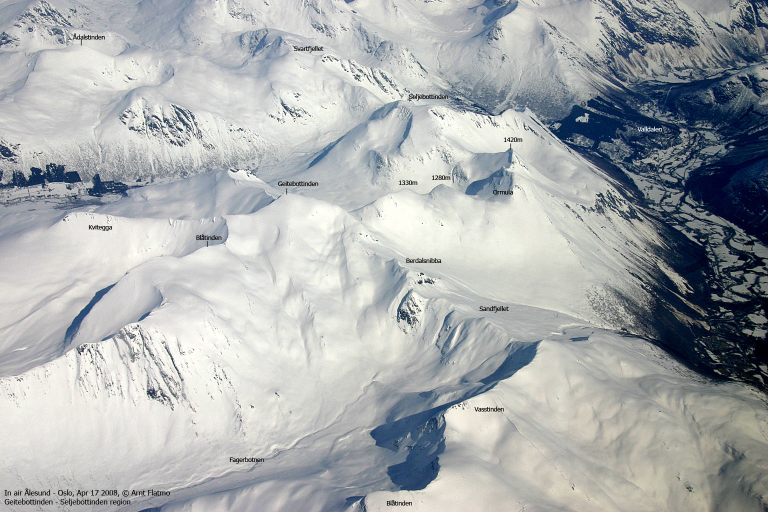
IntroductionAs the above aerial picture shows, Kvitegga is a part of the Geitebottinden - Seljebottinden massif, located between Stordalen and Valldalen valleys. Through the Rundeskaret pass, this massif connects in turn to a mountain range that runs all the way to Åndalsnes. Other known mountains in this range are Finnan, Kongen, Hesten, Høgstolen, Taskedalstinden and Ådalstinden. Kvitegga (The White Ridge) is one of the lowest tops in this mountain range, and is easily accessible from Langhaugbotn or Telbergsbotn. This page will describe a winter/spring skiing route via Langhaugbotn that should fit anyone. The Kvitegga ridge continues towards Geitebottinden, but this is an advanced route. Even in late April (while Ålesund is on the brink of summer), there is a chance that you can ski directly from the car. Primary factor:Kvitegga (Norge 1:50,000: 1311m, Økonomisk Kartverk: -, UTM 32 V 406765 6915806) has a primary factor of 61m towards the higher parent mountain Geitebottinden (1495m). The defining saddle (approx. UTM 32 V 406969 6915413) is found along the Kvitegga ridge. Ref. Norge 1:50,000 (20m contours), the saddle is within the contours 1240-1260m, interpolated to 1250m.
Google map
Google's interactive map. You can zoom, pan and click on the markers.
Trail descriptions
Notes: Class ratings are in reference to YDS. Click here for more information.
The trails described below are not necessarily the *easiest* trails to this mountain.
Access (all distances are approx. distances) From Ålesund (the nearest bigger city) follow highway E136->E39 towards Åndalsnes. From the E136/E39/Olsvika roundabout near Breivka, follow E39 approx. 28Km to the RV650 junction just after Sjøholt. Turn right onto RV650 (Geiranger/Stordal) and drive approx. 25,2Km (passing the place Stordal along the way) and turn left towards Overøye (signed). Drive 6,6Km and turn right towards Seljebotn (signed). Drive down a hill and attempt to find parking down by the bridge (310m elev.) without blocking for other traffic. You can also drive up the farm at Langhaugen (370m elev.) and ask for permission to park at/near the premises. The route 
The route from Langhaugen
Kvitegga summit is directly south of Langhaugen. But the Langhaughornet ridge will force you to pass a bit further west. Be aware of spring avalanches down from the Langhaughornet side. In other words, keep your distance to the mountainside. Once you're above the forest, you can maintain a gentle route and gain the ridge halfway between Nakkeskreda and Kvitegga, or follow a more direct (and more steep) route towards Kvitegga. You'll pass the Kvitegga
viewpoint cairn (UTM 32 V 406670
6915923) and a beautiful view
towards Stordal, before you reach the high point on the Kvitegga ridge, 150m to the
southeast. Descend your ascent route, unless you have a mountaineering project
ahead of you, involving Geitebottinden.
Pictures and Trip reports:
|


