
|

Fuglafjellet seen from Geitafjellet(No Javascript) |
Kvamskogen is the primary recreation area for the Bergen region, only less than one hour drive from Norway's 2nd largest city. While Tveitakvitingen (1299m) is perhaps the most visited of the higher mountains, Fuglafjellet is the highest in the region. As two majesties, these two mountains throne on opposite sides of highway 7.
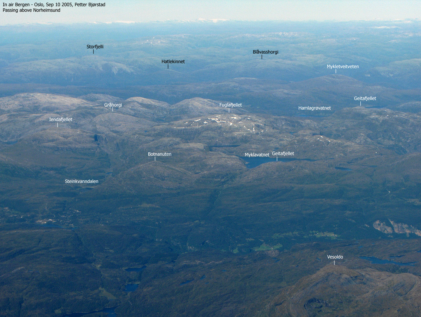
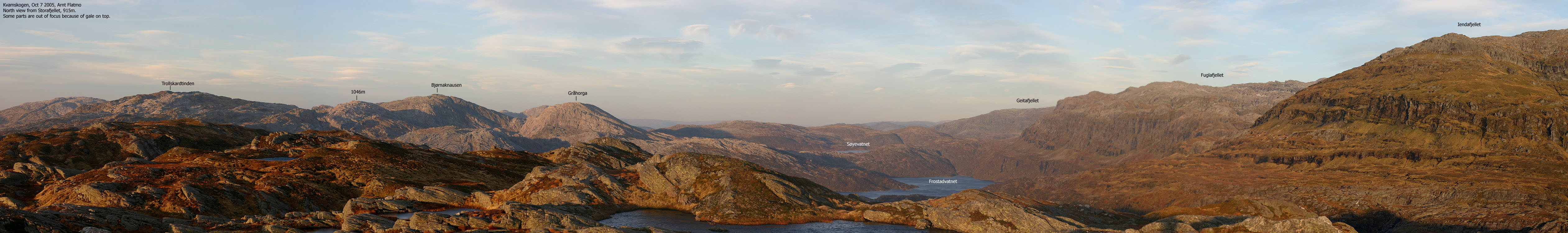
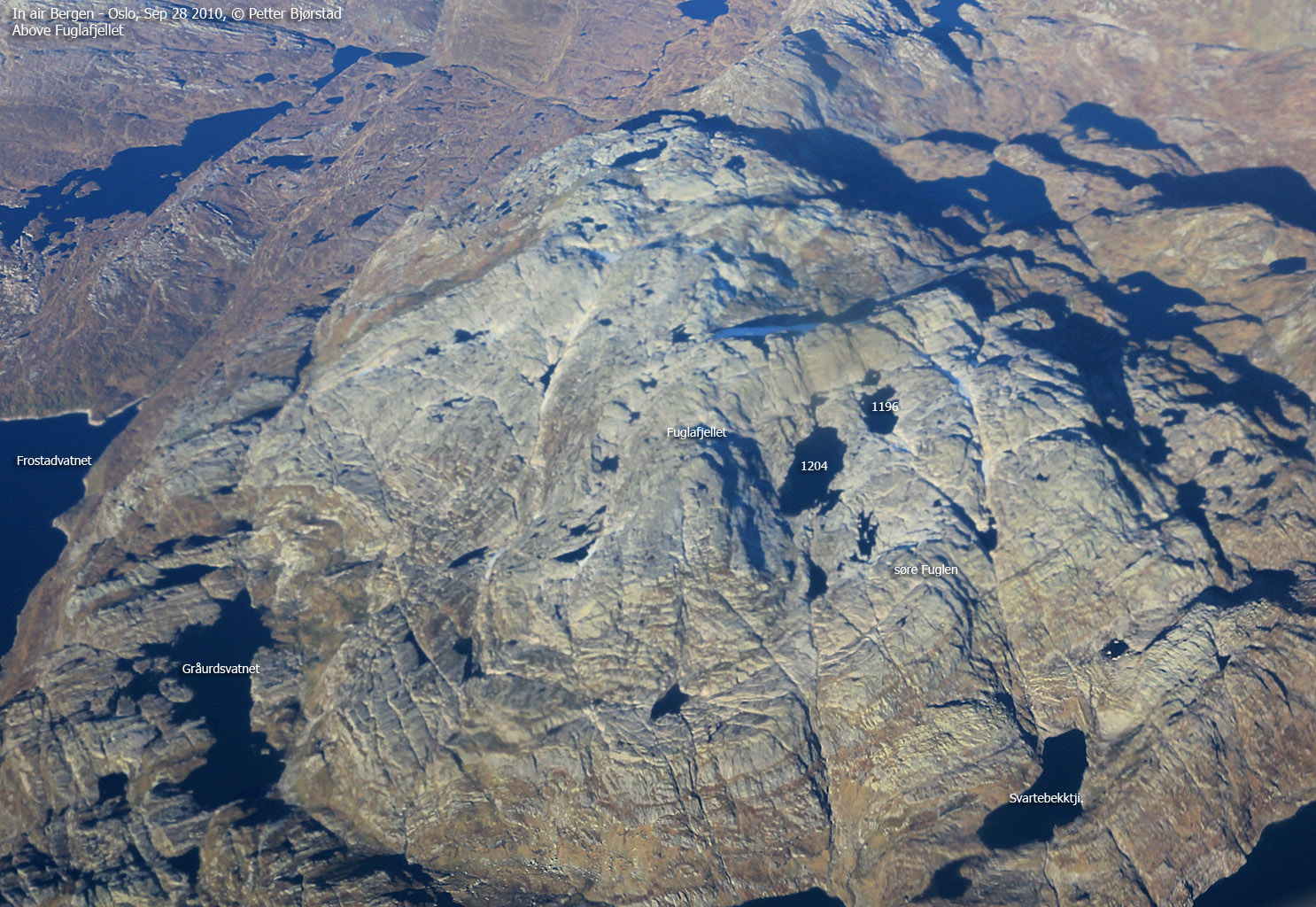
Fuglafjellet ("bird mountain") is a rough mountain with no public trails. There are some "trade routes" and paths, but the mountain is more attractive for those who enjoy seeking outside the regular trails. A characteristic feature is the many cliffbands that surround the mountain, offering challenges when the fog comes creeping in. The number of cliffbands also has a positive side in terms of many exciting routes up the mountain. This page will describe access from Steinkvanndalen. You may also ascend Fuglafjellet from Hamlagrø (via Vending) and from Øystese via Vossadalen/Fugladalen.
The views from the top are quite extensive, and the mountain ranks as #13 on the Hordaland primary factor list (high primary factor means good views) You may also be in luck an spot the herd on reindeer that is often sighted on this mountain.
Should you chose to hike this mountain from Steinkvanndalen valley, you have the option to include Iendafjellet (Såta) on the hike. The "ultimate" round-trip is going up Byrkjefjellet, continue across Iendafjellet, Fuglafjellet, Fotasperrnuten, Goddalseggene and descend via Botnanuten. This is a very long and strenuous hike and is recommended for those who can walk a full day in rough terrain. If you look at the Fotasperrnuten, Byrkjefjellet and Iendafjellet pages, you will have sufficient information for compiling this trip.
Fuglafjellet (M711: 1334m, Ø.K: 1334m) has a primary factor of 664m towards the higher Hjortahorgi (1351m). The saddle is found between lake Blåkollvatnet and lake Gråurdvatnet. These lakes are found south of lake Hamlagrøvatnet. Ref. M711 maps (20m contours), you cross the 680m contours on the high route, but not 660m. The saddle height is interpolated to 670m.
Notes: Class ratings are in reference to YDS. Click here for more information.
The trails described below are not necessarily the *easiest* trails to this mountain.
|
Steinkvanndalen - Fuglafjellet (summer/autumn)
|
|
From Bergen, follow highway E16 towards Oslo. At the highway E16/RV7 junction at Trengereid, turn right onto highway 7. Follow highway 7 over Gullbotn, down to Samnangerfjorden and through two tunnels before the road climbs up to Kvamskogen.
Approx. 38,6Km from the highway E16/RV580 junction at Indre Arna, you will see the NAF Camping on your right hand side. Stop here and ask for the key to Steinkvanndalen. There is a deposit for the key (NOK 100,- per June 2001) and the key rent is NOK 30,- (per June 2001). You may call +47 5655 3131 in advance to find out if the road is open for traffic. It normally opens when the road has "settled" after spring and stays open until late autumn.
Once the key has been retrieved, continue approx. 1,9Km. Turn left towards a Bed & Breakfast building on your left hand side. Turn immediately left onto a gravel road that leads to Steinkvanndalen. A gate blocks the road early on. Open and close the gate with the rented key. Proceed all the way to øvra Kvanndalsvatnet (5Km from highway 7). Make sure you turn left when you reach Steinkvanndalsvatnet, the first lake in this valley. The road up the valley can be rough in places, but you can drive a small passenger car on this road.
Follow the river north (5 minutes) until you reach a bridge. There is a hut on the other side of the river. Cross the bridge, and locate a trail next to the hut. The trail is "T" marked all the way to the top of Gråurdi pass. Up through the pass you cross a "forest" of huge rocks. Do not lose the trail, or you're in for rough scrambling. Note: there is another visible trail *before* you cross the bridge. This trail does not seem to lead anywhere.
At the top of the pass, turn east (right) and proceed towards a little pointy rock (1070m) Climb it! Next, proceed northeast and walk around lake Gråurdvatnet (lake 1014m). It seems natural to approach the mountain from the lefthand side while looking straight at it. The cliffs look too step to climb, but there are a couple of alternatives:
Alternative 1:
Looking at the eastern cliffs from lake 1014m, you will see a waterfall in early season. Go to the north end of lake 1014m and then turn south until you reach the center section of the mountain. You must start ascending before you reach the lower parts of the waterfall. There is a natural crossing before the final waterfall to lake 1014m. Head on up, aiming for the upper waterfall. Head up between the two leftmost smaller falls. A grassy slope will take you up on the mountain.
When you're above the waterfalls, you will se another cliff in the northeast. You will have to switchback to get up there. From the top of this level, you will now have a view of the top, and the cairn is just behind the point you see.
Alternatives 2 and 3 (round-trip):
Set course for the northern end of lake 1014m. Continue north for a couple of minutes, and you will arrive at a small lake which is a little awkward to pass on the east side. From this lake, head up a slope in the north-east direction, and follow a natural path in the terrain up to the mountain. This route may require minor scrambling, all dependent of the choices you make. Once on the massif, head southeast in the direction of the summit. A number of cliffs blocking your way will force you to switchback a number of times on the route to the summit. No difficult parts, though.
On your way down, you may choose to turn north when arriving the steep eastern side of Fuglafjellet (see the map). The northern route will take you down into a basin, enclosed by the points 1210m, 1249m and 1296m. The mountain side here is steep, but you may traverse the side in the north/northeast direction. Once down in the basin, head southwest, and you will arrive a steep side which looks quite ugly at first. But although a little steep, there is no problem to switchback down this side. Once down, move to the south end of lake 1016m, head a little north to onto higher ground and look for a trail. The trail runs south-west along side the Storaskori cliffs, before you return to the Fuglafjellet eastern basin. Head for Gråurdvatnet (lake 1014m) and you will rendevouz with your original track.
Alternative 4
This was sent to me by Rune Mjelde Blomberg. I have not explored this trail myself:
"The fastest way up from Steinkvanndalen valley runs up Skrukkane, up to the right just after Øvre Steinkvanndalssæter. The massif is climbed along the creek that flows out in Kvitebekk on the north-west side. A vague trail with some cairns is found here. When arriving the summit late fall, the snowfield just south of the summit has melted, and one can enter a cave towards the east - 4m high, 0,5m wide and 20m deep. 20m inside, the cave turns towards the right and the floor rises up. A flashlight would be handy at this point."
Thanks to Rune for this, and other info on Kvamskogen mountains.
Lots of places to refill water. This mountain looks very different going down, due to the many cliff systems. It is fairly easy to lose the track, so pay close attention to landmarks in the terrain. With snow on the mountain, walk as much as possible in the snow, but be careful about crevasses. In the autumn, the permanent snow is hard as ice, and should not be attempted without crampons. Some of the crevasses are deep enough to give you critical problems, in the event of a fall. In the summer season, cattle reside near the parking, and I've seen them mighty curious towards the cars. Also expect Gråurdi pass to be filled with sheep.
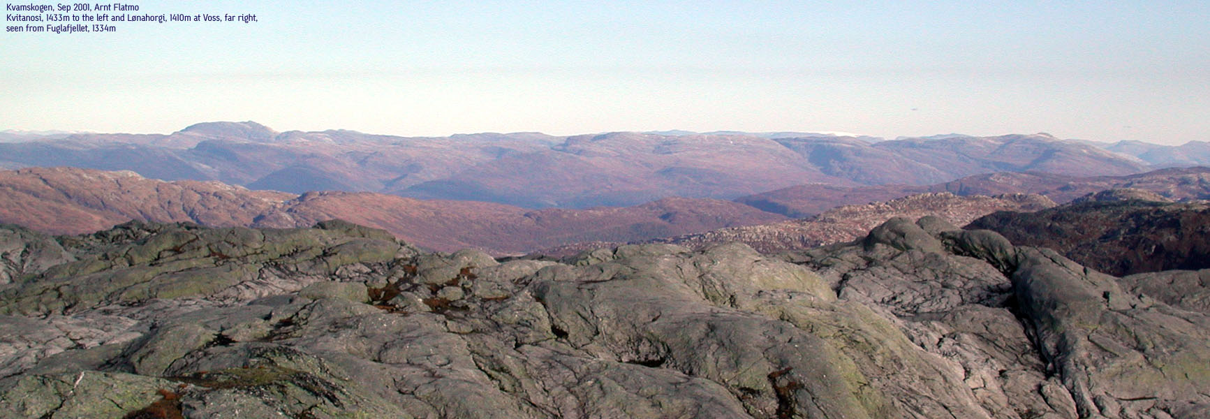
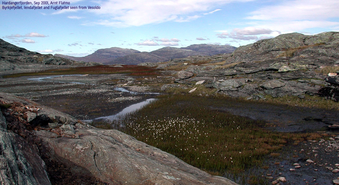
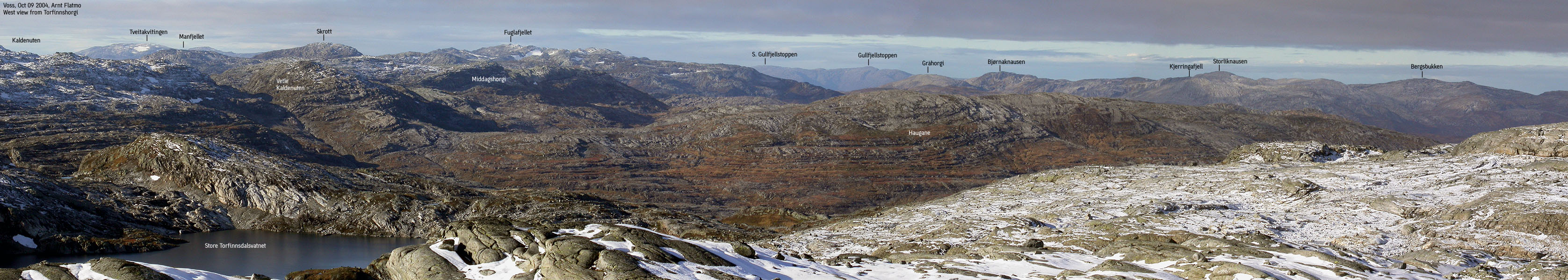
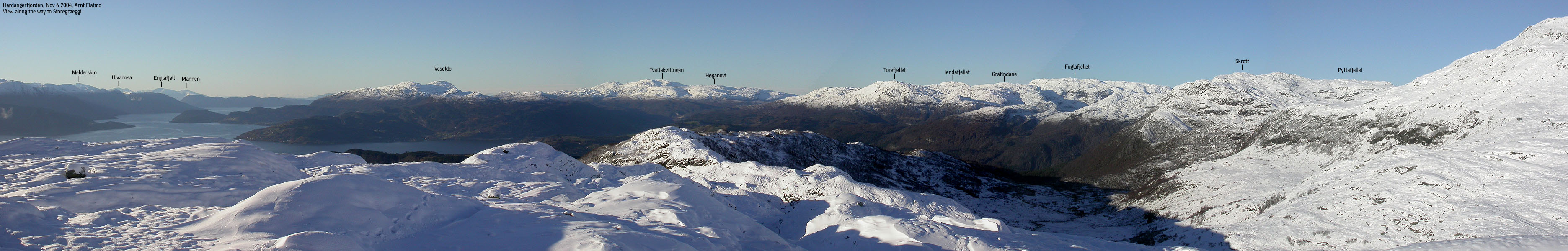
The view from Fuglafjellet is grand. Going 360 degrees, you see Folgefonna, Rosendal alps (Melderskin, etc), Ulvanosa, Bergen mountains incl. the Ulriken mast, Masfjorden, Stølsheimen with Kvitanosi in the centre, Voss (Lønahorgi), Fresvikbreen glacier, Voss/Hardangerfjorden mountains, Hardangerjøkulen glacier, Vassfjøra, and the mountains on northern Hardangervidda (Store-Flåtten).

|
Trip Report Sep 29 2001Talking to Petter Bjørstad, I learned that he and his twelve-year old son Pål Jørgen decided to go for the highest point in Kvamskogen the following day. Although I had some mountains to do in the Øystese region, I'm always glad to get company, so I quickly decided to join their project. At least I could bring some useful guiding, as I had visited this particular mountain once before, and knew the area well from other hikes. We arrived the NAF centre at Kvamskogen 08:45AM, and picked up the key to Steinkvanndalen. Although it is hard to enjoy this somewhat bumpy drive, we were busy enjoying the awesome Fotasperrnuten from the south. In addition, it looked to be the perfect day, almost too good to be true this late in September. We started the hike 09:15AM from lake Øvre Kvanndalsvatnet and made our way up the Gråurdi pass.
Peak 1070m I had promised Pål Jørgen an interesting scramble, so from the pass, we took a small detour over to peak 1070m. This peak looks hard to free-climb, coming from west, but going around the peak, a small ledge in the mountain offers an opportunity. The ledge can be accessed from the base of the peak, is narrow and calls for caution and precision while climbing the 2-3 meters up to safer ground. A fall would not be fatal, but could lead to something broken. Pål Jørgen - a seasoned climber at the age of 12 - just walked up and down. The ledge was not large enough for the grown-ups, so Petter and I had to use the gracious "on-the-ass" technique on the way down.
Fuglafjellet Content about the nice start of the day, we scouted for a way up to Fuglafjellet, and decided on a slope on north end of lake Gråurdsvatnet. We passed a couple of hunting parties, looking for grouse. They didn't seem happy to see us, but who cares. The route finding up the massif was enjoyable. While Petter was seeking a hikeable route (for reference to others), Pål Jørgen and I could monkey around, and go for small climbs here and there. Once on the massif, the hike over to the summit called for an infinite number of switchbacks due to the many ledges and cliffs blocking a direct approach. 2,5 hours after we left the car, we arrived the Fuglafjellet summit. After celebrating the summit for a few minutes, we decided to head down. The wind at this level was not favourable. We missed the route down and ended up further north. Fortunately, our new course led us safely down the mountain, and we picked up a trail that led us back to lake Gråurdsvatnet.
Iendafjellet, 1260m Back at Gråurdi pass, we decided to hike Iendafjellet (1260m) which was just on the other side of the pass. This would give Petter and Pål Jørgen Kvamskogen high points #1 and #3 this day. And they had already scaled Tveitakvitingen (1299m). At the start of the climb, Petter accelerated while Pål Jørgen started to fall behind. After all, we had hiked for about 4,5 hours in steep terrain. I was thinking to myself - I've got a twelve-year kid here, scaling two of the highest mountains in the area, in a killing pace. Now he's tired and hungry. Should I really drag him up to this mountain? But this is hardly the average 12-year kid. He has scaled about 50 4000m peaks since the age of 11. This is a kid who argues about the rating system of some of the highest peaks in the Rocky Mountains! And then I remembered Petter's description of the boy. "He's like a car. Just give him fuel and allow hime an occasional rest, and he's ready to go many more miles". I handed him a box of bisquits. "Nam", he replied and headed straight for the Iendafjellet summit. Pål Jørgen got his recommended break on Iendafjellet, and put his father well behind, on the way down. The evening sun was overwhelming and we had several breaks down through the Gråurdi pass. It felt as if it was a crime to leave the mountain on a day like this. We made it back to the car, 6,5 hours after we left it. A great day in Kvamskogen mountains was over.
Pictures from the Sep 29 2001 hike
Move cursor to read notes, and click on the images to see full version.
No Javascript: 1 2 3 4 5 6 7 8 9 10 11 12 13 14 15 16 17 18 19 20 21 22 23 24 25 26 27 28 29 30
|


No Javascript:
1 2 3 4 5 6 7 8 9 10 11 12 13 14 15 16 17 18 19 20 21 22 23 24 25
 Other hordaland mountains
Other Kvam K. mountains
westcoastpeaks.com
Other hordaland mountains
Other Kvam K. mountains
westcoastpeaks.com


