
|

Flæfjellet/Grøet seen from Totlandsfjellet(No Javascript) |
Børdalsfjellet, Grøet and Flæfjellet defines the beginning of the Kvamskogen mountains, on the north side of highway 7. These mountains are also indeed popular in winter, as this is the winter resort closest to Bergen. More known as Eikedalen ski centre. In summer, the area is far less popular, but many day hikers find their way into the beautiful Skeiskvanndalen valley.
A trail runs on each side of lake Skeiskvanndalsvatnet, and the easternmost runs from Teigen by highway 7 all the way to the dam at lake Svartavatnet. This is one of several routes from Kvamskogen to the Bergsdalen region. A variation to this route, from Eikedalen is to follow the trail to lake Skeisskardtjørni via lake Skeiskvanndalsvatnet (see below on this page), hike off-trail across Storafjellet/Røyrfjellet and arrive at lake Svartavatnet.
The neighbour Iendafjellet (1260m) blocks the eastern views, but you have excellent views in the other directions. Tveitakvitingen in the south, Bergsdalen mountains in the north and the Bergen mountains in the soutwest.
Litterature related to this region is the book "Kvamskogen" written by Svein Oldervoll Aadland. The book features many interesting stories from Kvamskogen (and Skeiskvanndalen) in addition to wonderful pictures.
Flæfjellet (M711: 939m, Ø.K: 938m) has a primary factor of 220m towards the higher Iendafjellet. The saddle is found in south of lake Kråketjørni. Ref. Økonomisk Kartverk (5m contours), you cross the 720m contours on the high route, but not 715m. The saddle height has been interpolated to 718m.
Grøet (M711: 920m, Ø.K: 920,17m) has a primary factor of 52m towards the higher Flæfjellet (938m). The saddle is found between the two tops. Ref. Økonomisk Kartverk (5m contours), you cross the 870m contours on the high route, but not 865m. The saddle height has been interpolated to 868m.
Note: Class ratings are in reference to YDS (Yosemite Decimal System).
Note: The trail described below is not necessarily the easiest trail to this mountain.
|
Eikedalen - Flæfjellet round-trip (summer)
|
|
From Bergen, follow highway E16 towards Oslo. At the Trengereid roundabout, turn right and follow highway 7. Pass Bjørkheim by Samnangerfjorden, drive through two tunnels, pass the highway 48 exit (Tysse) and set your odometer at the bridge by the Kvitingen exit. After 8,65Km, exit left towards Eikedalen. Drive approx. 500m until a gate blocks the road. Park near the gate.
Ascent
Pass the gate and follow the road until you are at the beginning of the easternmost (rightmost) skilift. A path runs directly below the skilift. The path more or less ends at the top of the ski-lift. Continue your path directly northbound and head up a boulderfield (if you don't like boulder, then you can follow the grassy hill to the top right and make it to the summit from there).
At the top of the boulderfield, you have another boulder gully ahead of you. Turn right and then left and follow more convenient terrain to the top of this gully. Follow further gullies and you soon will be on top of Flæfjellet. The summit is marked by a single rock. Note that the boulderfield gives this route YDS class 2. If you choose to bypass this boulderfield, the entire route is YDS class 1.
Descent
Descend your ascent route, or return via Skeiskvanndalen:
Set a northeast course for lake Skeisskardtjørni. You may follow vague paths, perhaps sheeptracks, but the terrain is gentle, so just head towards the lake. From the northeast end of the lake, follow the stream and look for a more distinct trail that evolves along the way. When the stream gets wider, the trail follows the river, a bit higher up, on the west side (on your right as you move downwards). The trail takes you (almost) down to lake Skeiskvanndalsvatnet and passes the innermost cabin.
From here on, the trail runs close to the lake. The trail can be immensly wet and muddy. You will be better off in the forest in the worst conditions. Pass the Herand cabins and enter the forest road when the rougher waterfalls begin. Follow the road back to the trailhead.
|
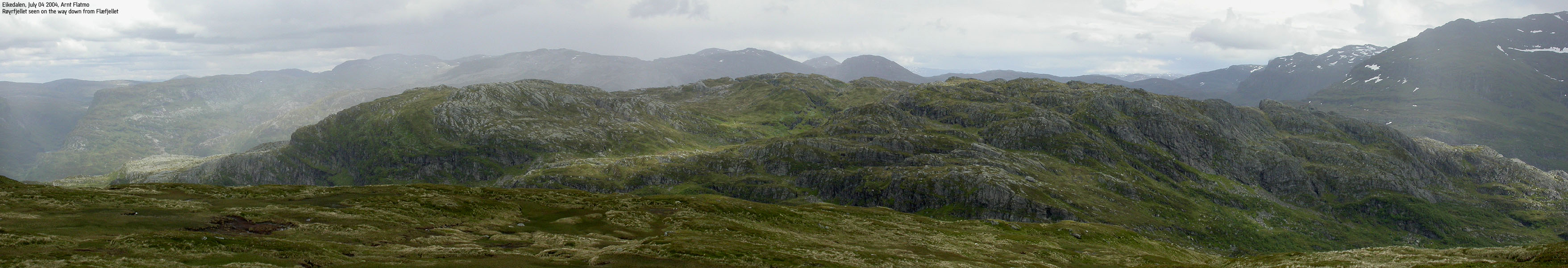
Trip Report July 04 2004I've been taking it easy for some days due to an inflammation in a leg. Staying home yesterday (Saturday) almost drove me insane. Random rainshowers helped a bit, but this Sunday, the weather was brilliant. I got desperate. I had been to the doctor on Friday. The doctor told me to take it easy for a few days. That was 15:30PM on Friday. If I went to Kvamskogen, I wouldn't get to start the hike until 13:00PM. That's aaaalmost "a few days". Close enough. I was that desperate. Leaving Bergen, I called my colleague Ketil Vevle and asked if he was up for a hike. His house is by Samnangerfjorden, and I could just pick him up along the way. By 12:40PM we were on our way from the Eikedalen parking. We had driven over Kvamskogen prior to the hike, checking out the dark clouds hanging over us. It was raining less than 1Km from Eikedalen - classical rainshowers sweeping across. The question where they were coming from, and where they were heading. Back at Eikedalen, everything was dry. Samnanger vs Kvam. At least according to Ketil, living on "the right side". Troll was thrilled to have extra company, and never considered the usual sit-down protest. We found a good path below one of the ski-lifts and continued up a boulder field when we were out of a path. It started to rain, and we took a small break below a convenient cliff. The rain didn't amount to anything, and we continued up the mountain. We arrived the summit 14:00PM. We did see some solid rainshowers in the horizon, and concluded we had been lucky so far. We agreed to return via Skeiskvanndalen valley. My ambition had be to include Røyrfjellet/Storafjellet on the return, but my leg now was now starting to get far worse, and I skipped the idea. I had been to Røyrfjellet, but visited the wrong top on my foggy hike in June 2002. Thus, I never visited the high point. Here it was, just 200 vertical meters above me, and I skipped it. Those who know me well will understand what kind of my shape my leg was in. Despite the lightning pain that was shooting down my leg, I enjoyed the hike very much. Skeiskvanndalen is a fine area. Cows were gathering around the cabin deep down in the valley. They didn't pay much attention to the visitors, except for a few that headed our way when we sat down for a little break. I didn't feel like introducing cows to Troll, or the other way around for that matter. We moved on and took our break further down the trail, outside cow views. The fog was now covering Iendafjellet, and we yet again mentioned that we had been fortunate, avoiding the rainshowers. On the other hand, we didn't have much good to say about the muddy trail. We got back to the forest road that led us back to Eikedalen. By 16:20PM, we were back at the car.
Pictures from the July 04 2004 hike:
Move cursor to read notes, and click on the images to see full version.
No Javascript: 1 2 3 4 5 6 7 8 9 10 11 12 13 14 15 16 17 18 19 20 21 22 23 24 25 26
|


No Javascript:
Other hordaland mountains
 Other Kvam K. mountains
westcoastpeaks.com
Other Kvam K. mountains
westcoastpeaks.com


