
Norwegian Mountains, Møre og RomsdalBrudefølget, 1345m (Brudefølgjet)
|
| Fylke/Kommune : | Møre og Romsdal/Vestnes, Stordal | ||||||||||
| Maps : | 1219-I Stranda (Statens Kartverk, Norge 1:50 000) | ||||||||||
| Primary factor : |
Brudefølget: 115m Rollsbotnskorka: 68m Litleskorka: 315m |
||||||||||
| Hiked : | July 2008 | ||||||||||
| See also : |
| ||||||||||
| See also : | Other Vestnes and Stordal mountains |
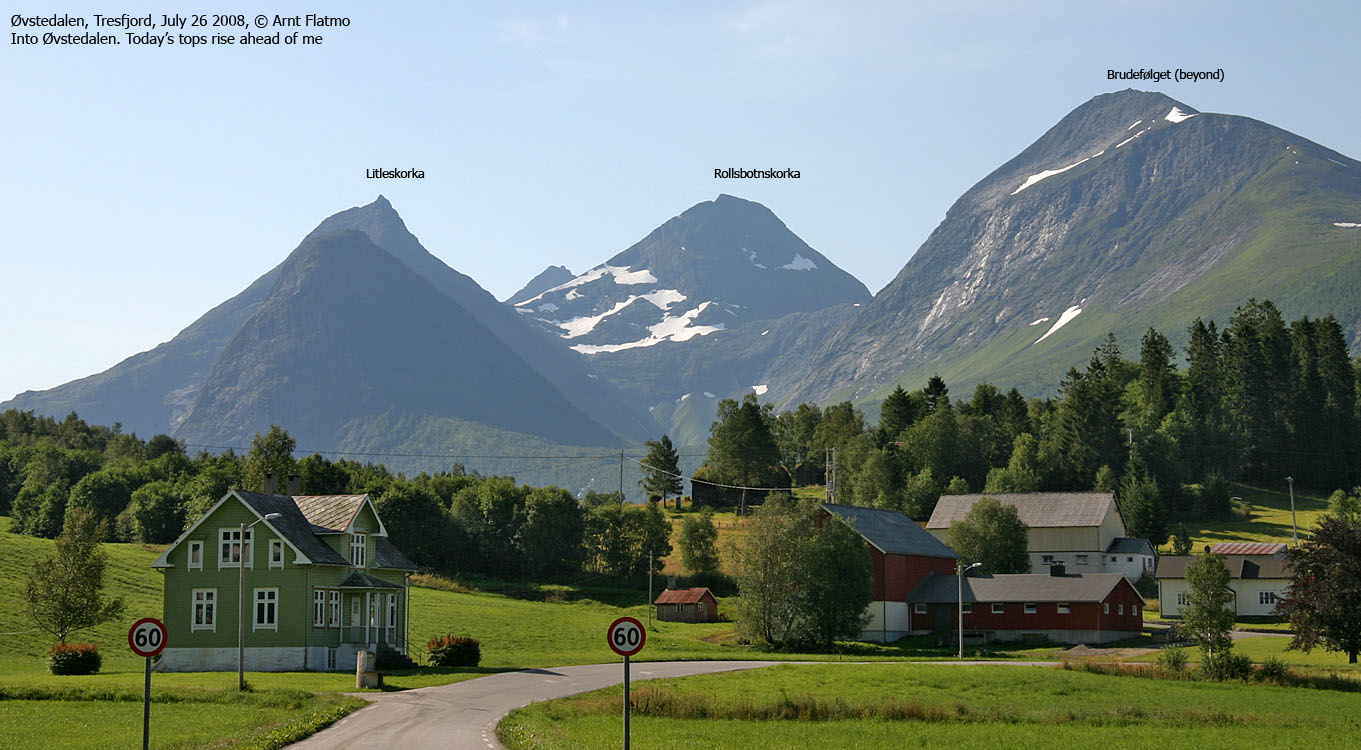
The tops seen from Tresfjord
(Click for larger image)
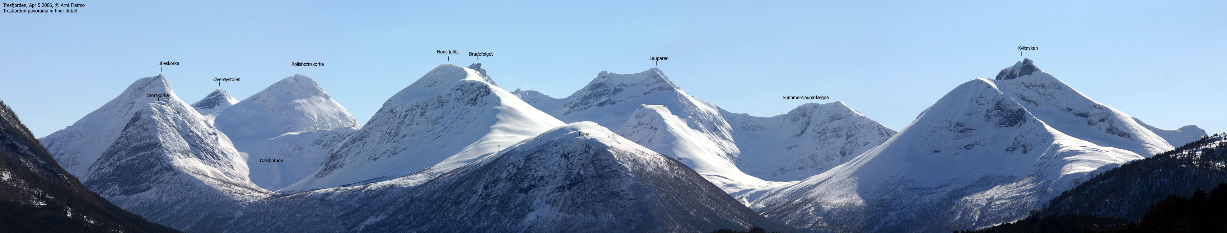
Brudefølget, Rollsbotnskorka and Litleskorka, are part of a mountain range that a.o. comprise Lauparen, Grytavasstinden, Storbotnshornet, and Øverøystolen. The peaks that are facing Tresfjord, are commonly called Tresfjordfjella. These three peaks are presented together, as the easiest route to Brudefølget passes Rollsbotnskorka and Litleskorka. Fit hikers could get a grand slam when they set out for Brudefølget.
Brudefølget (The Bridal Procession) is quite an unusual mountain name, and Norwegian romantic nationalism comes easily to mind. Brudefølget consists of a number of rugged peaks and pinnacles. The highest point can be reached through easy scrambling (YDS 3), but a section below the summit is extremely exposed, and even more dangerous if the mountain is not dry.
There are people who scramble between Lauparen and Brudefølget, but the easiest route runs from Kleiva in Øvstedalen. You head up either of Litleskorka's eastern ridges, pass Rollsbotnskorka on the north side, cross the ridge between Rollsbotnen and Dalsbotnen and scramble up to Brudefølget. Brudefølget's north ridge should be classified as a climbing route. Access via Dalsbotnen is most likely not very difficult, but the Kleiva route offers a higher trailhead, and a better path. Access via Rollsbotnen should also be straightforward, but the walk into Jasvollbotnen is a long one.
Rollsbotnskorka is a pointy peak which is easiest reached (marked route) on its northeast ridge. In winter, you might see ski tracks between Øverøystolen and Rollsbotnskorka.
Litleskorka is another pointy peak which is easiest reached on one of its two eastern ridges, or via the south flank (if you come from Overøye). There is a subsidiary peak to the north, which can be reached via descent from Litleskorka to the west. The north ridge continues towards Storskorka (861m), which is described on this page.
"Skork" is seemingly another word for pointy tops used in the Stordal-Vestnes region. In terms of Litleskorka vs. Storskorka, it is a bit odd that the highest of the two is called Litleskorka ("Little Skork"). This top is 303m higher than Storskorka ("Big Skork"). A plausible explanation is that the tops were named by people living in the upper part of the Øvstedalen valley, where the closest mountain (Storskorka) seemed larger than the other, being further away. A similar example is Straumshornet vs. Litlehornet in Sykkylven. Although Litlehornet is the higher peak, it appears more distant to the Straumsgjerde locals. To be noted; only 6-7Km to the southwest of Litleskorka, you will find Heimste (the closest) and Fremste (the most distant) Skorkja.

View from Dalsbotnen
(Click for larger image)
Brudefølget (Norge 1:50,000: 1345, Økonomisk Kartverk (ØK): -, UTM 32 V 403933 6926267) has a primary factor of 115m towards the higher parent mountain Lauparen (1434m). The defining saddle (approx. UTM 32 V 403395 6925614) is found between the two peaks. Ref. Norge 1:50,000 (20m contours), the saddle is within the range 1220-1240m, interpolated to 1230m.
GPS measurement on the summit cairn (1m high) read 1347m, averaged over a 10-minute period (error margin +/- 3,1m).
Rollsbotnskorka (Norge 1:50,000: 1333m, Økonomisk Kartverk (ØK): -, UTM 32 V 405135 6925280) has a primary factor of 315m towards the higher parent mountain Øverøystolen (1393m). The defining saddle (approx. UTM 32 V 405526 6923993) is found between the two tops (Raudeberget). Ref. Norge 1:50,000 (20m contours), the saddle is defined as a fixed point - 1018m.
GPS measurement on summit cairn (1m high) read 1341m, averaged over a 10-minute period (error margin +/- 1m). The track log is concurring. This is a notable deviation from the official height.
Litleskorka (Norge 1:50,000: 1164m, Økonomisk Kartverk (ØK): 1164m, UTM 32 V 32 V 405832 6926425) has a primary factor of 194m towards the higher parent mountain Rollsbotnskorka (1333m). The defining saddle (approx. UTM 32 V 405875 6925944) is found between the two tops, north of point 938m. Ref. Norge 1:50,000 (20m contours), the saddle is within the range 980-980m, interpolated to 970m
GPS measurement on the summit cairn (1m high) read 1165m, averaged over a 10-minute period (error margin +/- 1,5m).
Google's interactive map. You can zoom, pan and click on the markers.
|
|
|

Part of the route
(Click for larger image)
Access
(all distances are approx. distances)
The nearest larger city is Ålesund. From Ålesund, follow highway E136->E39 towards Åndalsnes. From the E136/E39/Olsvika roundabout near Breivka, follow E39 47,1Km (passing the place Sjøholt and Ørskogfjellet mountain pass along the way). Just before you reach Romsdalsfjorden, turn right towards Åndalsnes. Drive 7,7Km to Tresfjord, then turn right towards Øvstedal. Follow this road until it ends at 400m elevation. Pay toll (NOK 20,- per July 2008) at an unmanned toll booth down in the valley. Make sure you lock a gate down in the valley. Sheep and horses are up on the hillside. The last hill up to the parking is steep, and the road is rough. If you're driving a small car, consider parking lower down and walk the final 200m to the parking area.
|
Route 1: Øvstedalen - Litleskorka (summer)
|
|
The route
From the trailhead in Dalskleiva, follow a visible and marked route up to Lake Kleivvatnet. On the Sandfjellet - Litleskorka ridge, turn right (southwest) and follow a marked path up Litleskorka's east ridge. You will join the southeast ridge at approx. 1070m. Proceed northeast towards the summit cairn. If you find the ridge crest too airy, you can walk further down on your left-hand side. The summit is marked by a proper cairn.
Descend your ascent route, or continue towards Rollsbotnskorka or Brudefølget. Note that you have an alternative descent route in the southeast ridge. This ridge is rougher. There is no path, and the ridge has several cliffs that must be bypassed. The rule of thumb is to seek right (south) when you run into cliffs. When you're almost down by the lake, descend to the lake via some very distinct ledges.
|
Route 2: Øvstedalen - Rollsbotnskorka (summer)
|
|
The route
From the trailhead in Dalskleiva, follow a visible and marked route up to Lake Kleivvatnet. From the Sandfjellet - Litleskorka ridge, head down to Kleivvatnet and walk along the west side of the lake until you see some very distinct ledges that takes you onto Litleskorka's southeast ridge. There is no path, and you will need to find your way around cliffs. This route will take you up to the Rollsbotnskorka - Litleskorka saddle.
From the saddle, follow Rollsbotnskorka's northeast ridge, which is marked (red paint). The route follows the ridge until you're in front of a steep section below the summit. The route traverses a bit to the south (in the direction of Øverøystolen) until a scree area takes you up to the summit, which is marked by a proper cairn.
Consider descending the access route for Litleskorka (see above). This means you'll have to ascend from 970m in the saddle up to 1070m where the marked Litleskorka route comes up.
|
Route 3: Rollsbotnskorka - Litleskorka saddle - Brudefølget (summer)
|
|
The route
From the Litleskorka - Rollsbotnskorka saddle, descend north of point 938m and head west (slightly southwest) towards the ridge between Rollsbotnen and Dalsbotnen. Head for the steep hillside towards Brudefølget. A good rule of thumb is to stay left (but not as far as the slabs) to avoid scrambling. Just before you gain the ridge, you'll pass a cliff which you should pass on the right-hand side.
Once on the ridge, proceed towards the Lauparen - Brudefølget ridge. There is a narrow section which you can easily bypass on the left-hand side. Follow the ridge crest up to the first cairn, or look for easier sections to your left or right. From the first cairn (UTM 32 V 403958 6926208), you'll see the high point cairn, 65m to the north.
To get to the high point, descend 20m to the east, then descend north on exposed ledges until you are level with the gap between the two summits. As you try to get back onto the ridge, an obstructing rock will test your balance. This is an extremely exposed spot. Either crawl below or scramble on the obstructing rock (recommended). Once on the ridge, it is a fairly easy scramble to the top. You'll probably seek to the right just before the top, and you'll probably find descending this section to be slightly awkward. But there is no direct exposure, as long as you're on the ridge proper. The summit is marked by a proper cairn.
Tresfjord peaks
(Click for larger image)
 westcoastpeaks.com
Other Møre & Romsdal mountains
Other Norwegian mountains
westcoastpeaks.com
Other Møre & Romsdal mountains
Other Norwegian mountains


