
|

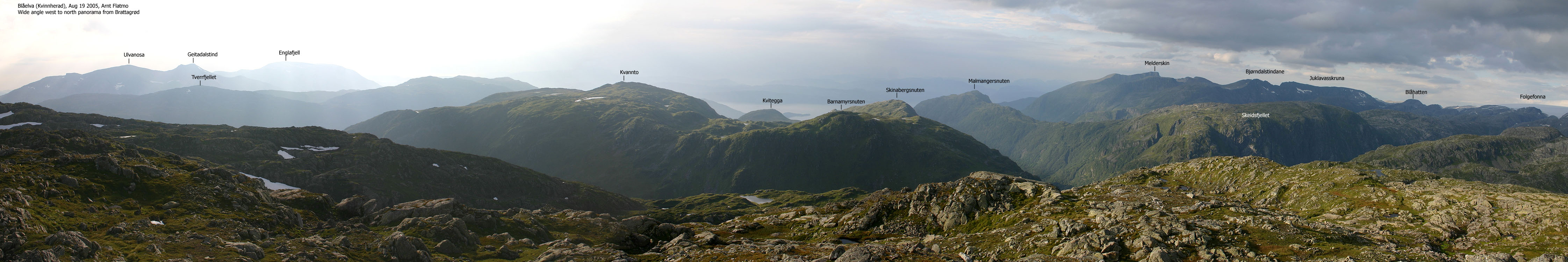
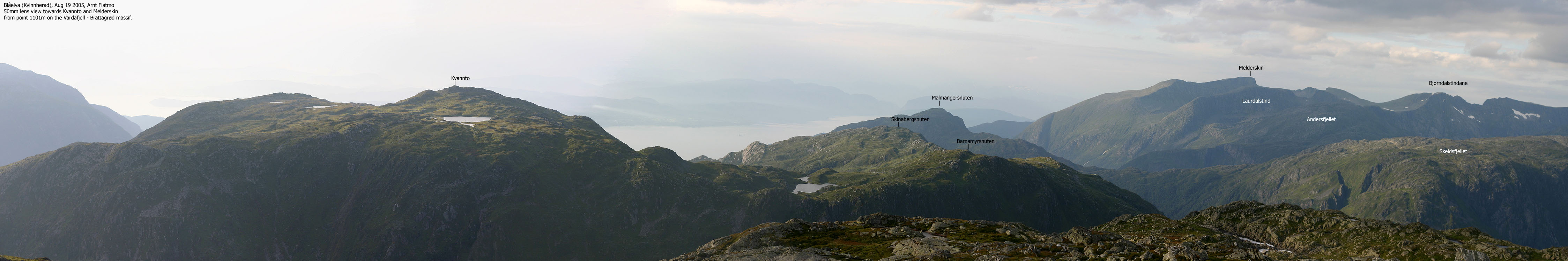
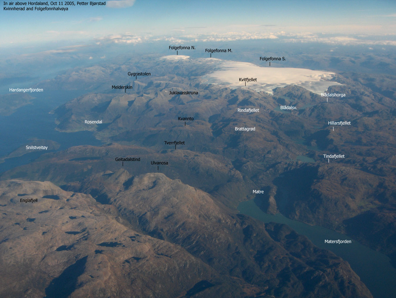
Brattagrød is one of the finest viewpoints between Rosendal in the north and Åkrafjorden in the south. The 360 degree view consists of the "Rosendal alps" and the Folgefonna glacier to the north and east, the Etne mountains to the southeast and south and Ulvanosa/Englafjell to the west. In addition, you will see a number of peaks on the west side of Hardangerfjorden.
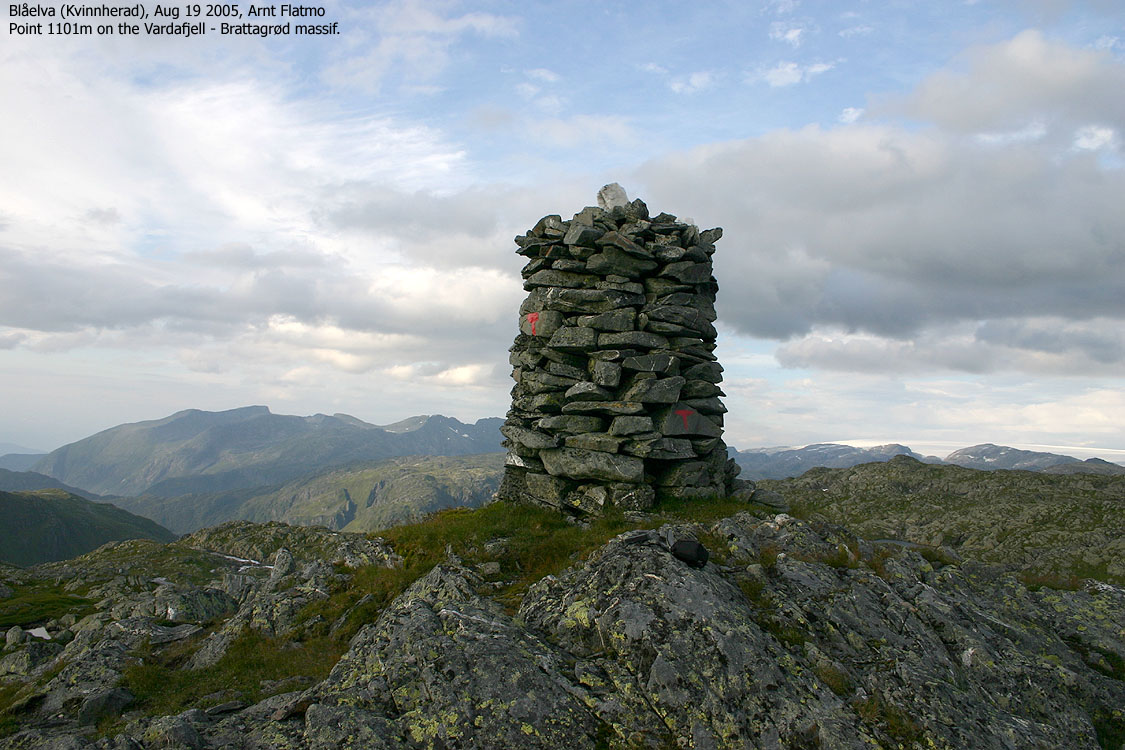
The mountain plateau on which Brattagrød is the high point, consists also of point 1101m and Vardahorga (1056m). The common name is "Vardafjell" and the main cairn is found on point 1101m. Brattagrød has only a modest rock marking the high point.
The main (marked) trail to Vardafjell runs from Åmvikedalen/Myklebustdalen via Lake Aursdalsvatnet and up to point 1101m. The route described on this web page runs from Blåelva and although most of the route is off-trail, this route is shorter. The terrain from Blåelva is in general very easy to follow.
Brattagrød (1214-I: 1111m, Ø.K.: 1111,35m) has a primary factor of 181m towards the higher Rindafjellet (1155m). The saddle is found N of Lake 923m. Ref. the 1214-I map (20m contours), you cross the 940m contours on the high route, but not 920m. The saddle height has been interpolated to 930m. Over a 10-minute period, I measured (GPS) the summit (no cairn) to be approx. 1112m.
Vardafjell (1214-I: 1101m, Ø.K.: Highest contour is 1095m) has a primary factor of 58m towards the higher Brattagrød. The saddle is found south of the lake (1043,5 on Ø.K.) between point 1101m and Brattagrød. Ref. Økonomisk Kartverk (5m contours), you cross the 1045m contours on the high route, but not 1040m. The saddle height has been interpolated to 1043m.
Note that on the 1214-I Kvinnherad map edition (the map is now named 1214-I Rosendal, this point is named 1011m. It is reasonable to assume that Statens Kartverk has mixed up some of the digits. Over a 10-minute period, I measured (GPS) the summit (top of cairn) to be approx. 1103m. Given a small error margin, the height (1101m) seems fairly correct.
Notes: Class ratings are in reference to YDS. Click here for more information.
The trails described below are not necessarily the *easiest* trails to this mountain.
|
Blåelva - Brattagrød - Vardafjell (summer/autumn)
|
|
From Bergen, follow highway E16 (Oslo). At the Trengereid junction (approx. 25 minutes from Bergen), turn right onto highway RV7. When you arrive Bjørkheim by the Samnangerfjord, drive through two tunnels, and turn right onto highway RV48 (Tysse/Mundheim/Rosendal) shortly after the second tunnel.
Follow highway RV48 to Mundheim by Hardangerfjorden and turn right towards Gjermundshamn (RV49). Take the Gjermundshamn - Løfallstrand ferry. Sometimes this ferry makes a stop at Varaldsøyni island. Allow 2 hours for driving from Bergen to Gjermundshamn, and dialing 177 (Norwegian short-dial for traffic information) or checking hsd.no for ferry departures might be a good idea. Onboard the ferry, you may also obtain the ferry schedule in the cafeteria.
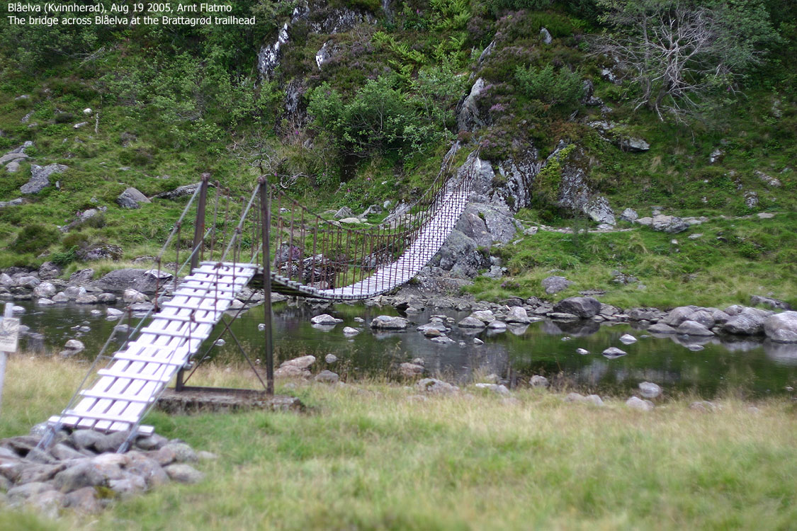
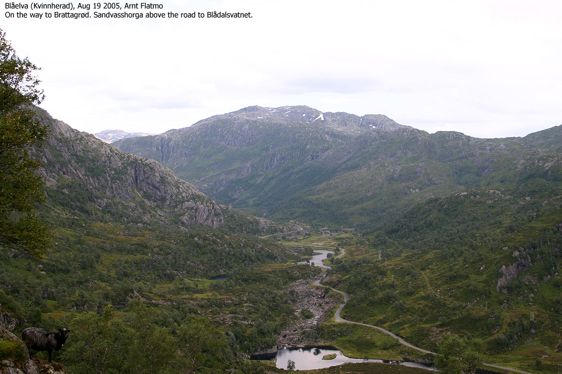
From the Løfallstrand RV48/RV551 junction, turn right towards Rosendal and drive 8,4Km (pass Rosendal and Dimmelsvik). Turn left towards Omvikdal/Åkra/Matre and follow this road 9,9Km. Turn left towards "Blådalsvatn" and follow this road 3,1Km (along Lake Fjellhaugvatn). Turn left towards "Blådalsvatn" in the new junction and drive approx. 5,4Km in the direction of Blådalsvatnet.. You should now have a bridge across Blåelva to your left.
Brattagrød
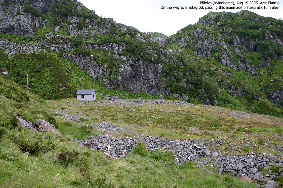
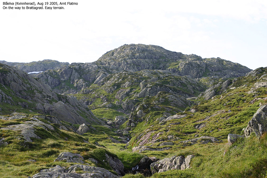
Cross the sway bridge, turn right and follow a visible path that leads up to a cabin at approx. 610m elevation. Turn left and head west/northwest up the hillside until you join the main stream down the mountain. Hike along side the stream upwards. When you see another stream come down up to your right, follow the terrain between the two streams and follow a ridge upwards. You will probably enter the summit plateau approx. 300m south of the summit. The summit is marked by a modest rock.
Vardafjell
From Brattagrød, head southwest towards the north end of the lake that is found east and below point 1101m. Proceed up to the large cairn. Easy terrain, as long as you follow the highest contours.
Descent
Pass the lake on the south side, head eastbound and cross over the ridge that leads to Brattagrød. Descend into a valley and join your ascent route at approx. 870m elevation.
|
Trip report continued from Blådalshorga.
To Brattagrød and Vardafjell After having visited Blådalshorga, I still had time for one more mountain before I had to go looking for a camp-site. I searched the map for a nearby "hit-and-run" mountain and Brattagrød appeared as the obvious candidate. The time was 17:05PM when I left Blådalsvatnet, and by 17:15PM, I was on my way to Brattagrød. After following the trail up to a cabin and a peculiar, large manmade plateau, I went off-trail and just headed upwards without any sort of plan. I ended up in a valley and followed a stream upwards. My direct route led me into minor scrambling terrain which I easy could have avoided. I adjusted the course and followed a ridge (not a very distinct one) that took me up to the high plateau. I noticed the high point, a few hundred meters towards the north. While heading over there, I also kept looking towards a similar-height point further west. This point had a large cairn, while I couldn't see one in the direction I was heading. I reached Brattagrød 18:25PM and concluded after a while that my GPS and the map height seemed to conform. I kept staring towards the other point and decided that I should visit this point too, just in case. I reached point 1101m 18:55PM and the conclusion was that the map height seemed to be correct here as well. Although I understand that there is normally a good reason for a cairn's location, it can be "frustrating" for top collectors when the cairn and the high point are almost 1Km apart.
Damned sheep From Vardafjell, I took a direct route down the mountain and planned to join my ascent route in a fine and graceful manner. On my way down the valley, a flock of sheep came running my way. My generic intuition tells me to sit down and talk to the sheep, but I always end up trying to chase them off. That's the recommended practice, as it is preferrable that the sheep stay on the high mountain. Besides, they're obviously not running down the valley for a good conversation, and I am not the salt guy. But this flock wouldn't give up without a fight and refused to move more than inches away. First thought: "outrun them". The attempt failed. Big time. Second thought: "confuse them". I jumped across the stream, then back again, then back over the stream and so on. They walked down along the stream while their bleat caused sheep from the neighbouring valleys to join in. Third thought: "climb". But would they follow? Can I outclimb sheep? Fourth thought: "Head back up". I did, and they followed. Fifth thought: "act crazy". This made them nervous, but they didn't move. The final solution now became apparent; Act crazy, head upwards, turn around, cross the stream, climb up a cliff and run like hell down the neighbour valley. This worked! But when I entered the neighbour valley, another flock came running towards me. I surrendered and had company all the way down to the trailhead.
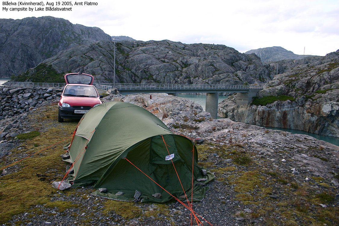
Camp-site The time was 19:45PM and I left the flock of sheep to look for a camp-site. Every grassy spot was full of sheep droppings. I headed up towards Lake Blådalsvatnet and had to pass the dam before I found a spot that wasn't full of shit. This also meant that there wasn't any grass, but I didn't care. I rigged the tent before preparing dinner. While dinner was cooking, I sat on a rock and enjoyed a beer. "This is the life", I told myself. Somehow, it didn't sound convincing, so I had to repeat it. It still didn't sound convincing, and I felt I should try to be honest. "This is actually a bit boring" had honesty written all over it. I am a restless soul. I can work on a computer for 24 hours straight, or hike from summit to summit until I can walk no further. But to sit here and watch the grass grow? (and this place didn't even have any!). I had brought a book, but suddenly remembered that I had read it already. I went to sleep and woke up one hour later. The rain was pouring and the wind was trying to sweep the tent away. This felt better. Some "action" at last. Camp-life had turned more enjoyable and I wondered what kind of weather I could expect on my Kvitafjellet hike the next day. Trip report continues on the Kvitafjellet page.
|
To Brattagrød


Summit views


Vardafjell


Camp-site


No Javascript:
1 2 3 4 5 6 7 8 9 10 11 12 13 14 15 16 17 18 19


No Javascript:
 Other hordaland mountains
Other Kvinnherad K. mountains
westcoastpeaks.com
Other hordaland mountains
Other Kvinnherad K. mountains
westcoastpeaks.com

