
|

Bjørndalskamben seen from Tverrfjellet(No Javascript) |
Bjørndalskamben is found south on the Vikafjellet mountain plateau. The summit is shared by Sogn of Fjordane fylke (county) - Vik kommune and Hordaland fylke - Voss kommune. Where highway 13 switchbacks up from Holå to Vikafjellet, you will see Bjørndalskamben up to your right.
The mountain is very popular in both winter and summer. A popular summer trail runs from Kvassdalen while Revhaugen (south) is a popular place to ski from in winter. The route from Kvassdalen is described on this page. Per July 2004, there were two (!) registers on the summit - one for Vik and one for Voss.
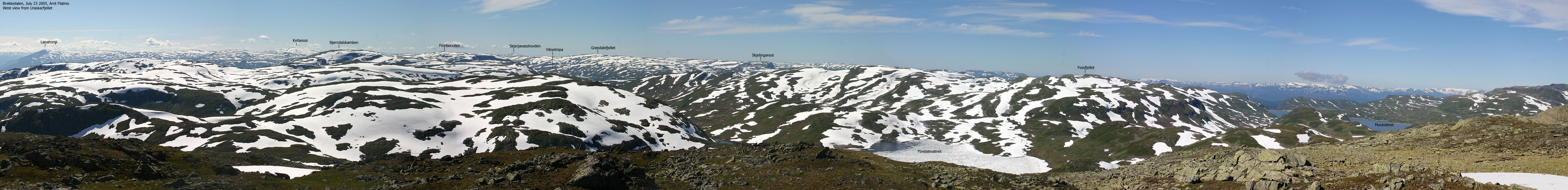
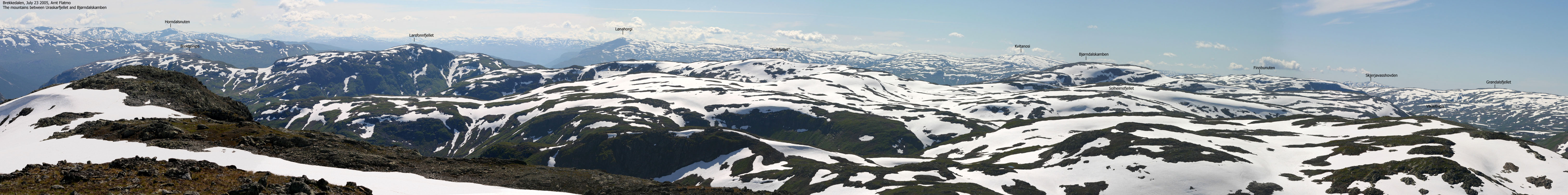
The views are quite extensive. You have a good view northbound across Vikafjell and towards the high Sogn mountains in the horizon. Finnbufjellet and Grøndalsfjellet takes away some of the views towards Stølsheimen, but you have good view towards mountains such as Kvitanosi, Lønahorgi, Raundalsegga and up to Storebreen. I'm not 100% sure, but I believe you see the Jostedalsbreen glacier from the top. In addition you see the Hardangerjøkulen, Folgefonna and Fresvikbreen glaciers.
Bjørndalskamben is absolutely a mountain for everyone. No difficulties on the easiest routes, and the mountain is well suited for families. Typical for this region is grass high on the mountain. You are likely to see sheep above 1200m in summer.
Primary factor:
Bjørndalskamben has a primary factor of 272m towards the higher Uraskarfjellet. The saddle is found in Viksetskaret pass, south of Viksetnipa. The M711 map states that the 1140m contours define the saddle. The saddle height has been interpolated to 1130m.
Notes: Class ratings are in reference to YDS. Click here for more information.
The trails described below are not necessarily the *easiest* trails to this mountain.
|
Kvassdalen - Bjørndalskamben (summer)
|
|
From Bergen, follow highway E16 to Voss. From the traffic light downtown Voss, turn left and follow E16 approx. 1,3Km to the E16/RV13 junction. Then turn left and follow E16 approx. 18,9Km and turn left again in the roundabout at Vinje. Follow RV13 approx. 14,7Km and find parking by some buildings on your left. This is normally a goat farm in summer. The switchbacks up to Vikafjellet is ahead of you.
Locate a narrow path that runs upwards, on the right hand side (east) of the road. At first glance, it doesn't look like it's possible to go straight up here, but the trail is cleverly made and will take you safely up the plateau above. Continue northeast until you join the river from Bjørndalen. Note that the trail runs over some wetlands on the way to the river, and could be less visible here. Be observant, so you find the right route while descending. Follow the trail along the river up to the Bjørndalen cabins.
From the cabins, the rest of the route is quite obvious. Follow a trail that continues from the cabins and runs up the Bjørndalskamben northwest ridge. After a while, the trail turns into two trails. One runs on the north side of the ridge, the other one on the south. You may lose the trail now and then, but being in high country, you really don't need a trail. The resident sheep are maintaining the trails, and you will notice that some trails ends at a natural sheep shelter.
The summit area have steep cliffs to the west, but convenient access is found further right (when you look at the cliffs). The route up to the summit is marked by small cairns. The summit is marked by a proper cairn, and per Aug. 2004, there were two trail registers (one for Vik, one for Voss) on the summit.
Winter notes:
This route should be avoided in winter. In icy conditions, the trail up from RV13 may also be dangerous. Better alternatives exist. Normal skiing route is from Revhaugen, south of Bjørndalskamben. Avalanches from Bjørndalskamben may occur in winter, and even block RV13. There are driving restrictions across Vikafjellet in winter (gates) and the road is closed in severe weather.
After a memorable hike with Elysa and Rohan on Ulvanosa the day before, we woke up at Bavallstunet (Voss) to yet another lovely day. After dropping the others off in Voss and wishing them good luck with the rest of their vacation in Norway, I headed towards Bjørndalskamben. I wasn't sure where the best route was, and stopped by the goat farm by the switchbacks up to Vikafjell.
I spent a good while talking to Olav Farestveit and his brother. They recommended I went straight up and pointed to a trail that headed *straight up* the steep hillside. We also talked about Hordaland mountains in general until became apparent that we had been on Greenland at the same time in May. Olav and a friend had crossed the ice on a 23-day hard journey. Quite a coincidence. There weren't *many* Norwegians on Greenland in May, and it was a bit odd to meet someone who indeed was there. He had an interesting story to tell. When he told me they had to dig the tent completely down due to fall winds, I realized we had been tremendously fortunate with the weather.
11:20PM, I headed up the trail they had pointed out. It was very warm and very steep and I had to carry Troll up the amazingly steep hillside. Once in more level terrain, I let Troll out, and I walked almost to the top. When we arrived the cabins at Bjørndalen, the ridge route to the summit was quite obvious. Some dark clouds made me wonder if we would run into rainshowers, but not a single drop fell during our hike. Actually, the weather improved quite a bit on our way down.
We reached the summit 13:20PM. I had seen one person on the top, and ran into another hiker below the summit cliffs. We walked up together. On top, we saw 5 people, and to my surprise, I was #24 on the summit this Sunday. I learned later that this was not the usual Sunday attendance. A group of 21 people from Vik had been on the summit just before we arrived. During the lunch break, I saw massive rainshowers over Raundalsegga, and decided it was time to leave. The rain never came our way and after a pleasant hike downwards, we arrived the car 15:11. Olav came back out and we continued exchanging Greenland experiences. After a long and pleasant chat, it was time to head back to Bergen.
Move cursor to read notes, and click on the images to see full version.
Some of the thumbnails may have been cropped to fit the format.


No Javascript:
1 2 3 4 5 6 7 8 9 10 11 12 13 14 15 16 17 18 19 20 21 22 23 24 25 26 27 28 29 30 31 32


No Javascript:
Other hordaland mountains
 Other Voss K. mountains
westcoastpeaks.com
Other Voss K. mountains
westcoastpeaks.com

