
Norwegian Mountains, Møre og RomsdalBåsenibba, 910m (Ljønibba)
|
| Fylke/Kommune : | Møre og Romsdal/Stranda | ||||||
| Maps : | 1219-II Geiranger (Statens Kartverk, Norge 1:50 000) | ||||||
| Primary factor : |
Båsenibba: 120m Sætrenibba: 109m |
||||||
| Hiked : | Nov 2008 | ||||||
| See also : |
| ||||||
| See also : | Other Stranda mountains |

Sætrenibba and Ljøsætra
(Click for larger image)
The mountain ranges on both sides of Strandadalen meet near Lake Nykkjevatnet, just west of (and above) Ljønibbtunnelen (tunnel) between Stranda and Hellesylt. The mountain pass is found between Lakes Nykkjevatnet and Kremmarvatnet, and Den Trondhjemske Postveg (old postal route, seen on the above picture) runs across this pass. Sætrenibba and Båsenibba (Ljønibba) are two tops that rise above this pass.
Sætrenibba is very accessible from the south; you follow the postal road up past Ljøsætra, and a path runs up to the top. Båsenibba may seem a bit daunting at first glance, but the route up the south side is quite trivial. You can also hike from the north; you follow the postal road past Lake 602m and head for Båsenibba or Sætrenibba once you've passed Kremmarvatnet.

Båsenibba (foreground)
(Click for larger image)
Båsenibba and Sætrenibba, along with Skurdahornet, are the three lowest independent tops (primary factor >= 100m) in the municipality of Stranda, and they are surrounded by much higher peaks. If you want to see hundreds of mountain tops, these tops should not be your first choice. But the Geirangerfjord view (this fjord is one of Norway's major tourist attractions) will make your visit well worth while. And the hike along the postal road is excellent as a family hike. You can get to Ljøsætra with the smaller kids. If the kids are up for some walking, you can leave one car at each end of the postal road, and walk across. Båsenibba and Sætrenibba are there for grabs, only 15-20 minutes away from the postal road.
Båsenibba (Norge 1:50,000: 910m, Økonomisk Kartverk (ØK): 909,67m, UTM 32 V 391829 6891614) has a primary factor of 120m towards the higher parent mountain Blåfjellnibba SE-1 (1451m). The defining saddle (approx. UTM 32 V 391521 6891352) is found between Lakes Kremmarvatnet and Nykkjevatnet. Ref. Norge 1:50,000 map (20m contours), the saddle is within the range 780-800m, interpolated to 790m.
GPS measurement on the summit (ground) read 912m, averaged over a 5-minute period (error margin +/- 1,2m).
Sætrenibba (Norge 1:50,000: Highest contour is 840m, Økonomisk Kartverk (ØK): -, Suggestion: 859m, UTM 32 V 391349 6890816) has a primary factor of 109m towards the higher parent mountain Blåfjellnibba SE-1 (1451m). The defining saddle (approx. UTM 32 V 390894 6891015) is found on the southwest side of Nykkjevatnet. Ref. Norge 1:50,000 map (20m contours), the saddle is within the range 740-760m, interpolated to 750m.
GPS measurement on the summit cairn read 865m, averaged over a 5-minute period (error margin +/- 4m). The suggested height of 859m is set in order not to exceed the 860m contour (which is not on the map).
Google's interactive map. You can zoom, pan and click on the markers.
|
|
|
|
Route 1: RV60 - Sætrenibba - Båsenibba (summer/autumn)
|
|
Access
(all distances are approx. distances)
The nearest larger city is Ålesund. From Ålesund, follow highway E39 towards Bergen, and then highway RV60 (Stranda) to the Magerholm - Ørsneset ferry. This ferry runs quite often; every 20 minutes during the busy hours of the day. From Ørsneset, drive RV60 to Stranda (34,3Km). Turn south (right) and continue on RV60 towards Hellesylt. Drive through the Ljønibbtunnelen tunnel and find parking on the left-hand side of the road, next to a shed, 900m after the tunnel exit, (23,5km from the Stranda junction).
The route
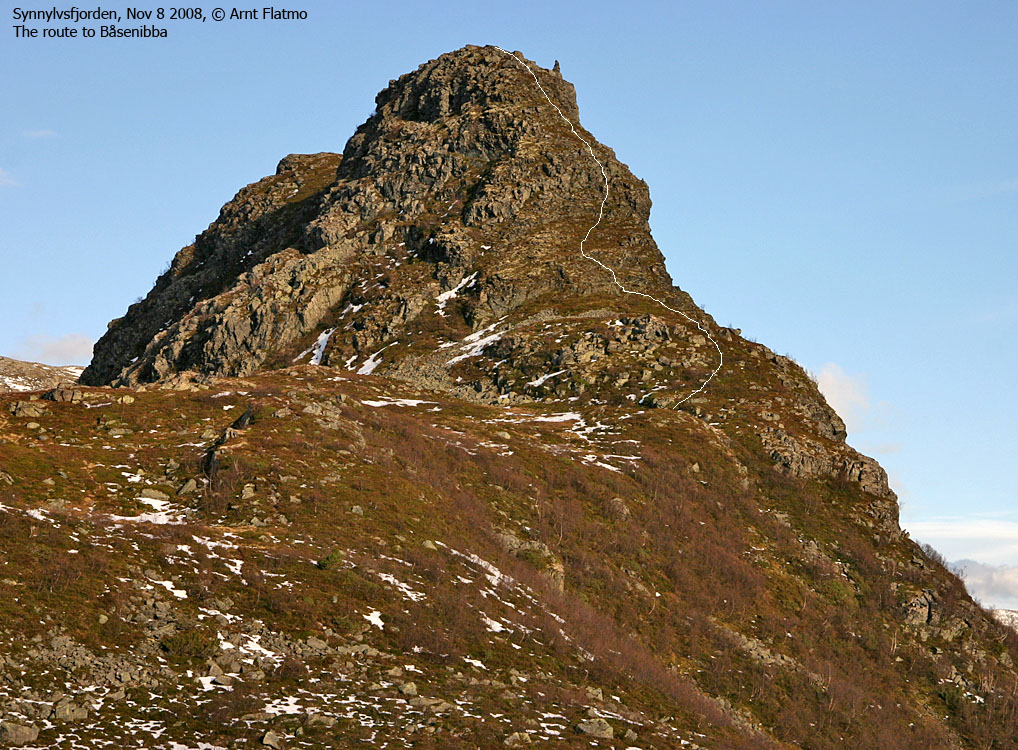
The route up Båsenibba
(Click for larger image)
Sætrenibba
Locate the postal road sign on the other side of the road (cross the bridge) and follow it up to Ljøsætra. You'll pass the Spønhaugen ruins at 490m. At Ljøsætra, leave the postal road and scramble up a boulder field (note a long piece of rock along the way), stay to the right so you'll find a cairn at 800m (UTM 32 V 391399 6890642) - a nice viewpoint. Proceed up to Sætrenibba summit, which is marked by a cairn.
Båsenibba
Don't attempt to descend Sætrenibba to the north. Instead, descend to the southwest, into a gully between Sætrenibba and the hump to the west. Don't descend directly to Nykkjevatnet, but traverse until you reach Sætrenibba's north ridge. Cross the drain from Nykkjevatnet and head for Båsenibba.
In a while you'll come across a path, and you might see the Båsenibba sign. The ascent is steep, and a small section may qualify as a scramble. Pass the cairn, then descend a few meters until you reach the summit, marked by a trigonometric point (fallen per Nov. 2008).
Descent
Descend from Båsenibba and join the postal road between Nykkjevatnet and Kremmarvatnet. Then follow the postal road back to the trailhead.
 westcoastpeaks.com
Other Møre & Romsdal mountains
Other Norwegian mountains
westcoastpeaks.com
Other Møre & Romsdal mountains
Other Norwegian mountains


