Norwegian Mountains, Sogn og FjordaneHjelmen, 1215m
|
| Fylke/Kommune : | Sogn og Fjordane/Bremanger | ||||
| Maps : | 1118-I Måløy (Statens Kartverk, Norge 1:50 000) | ||||
| Primary factor : | 385m | ||||
| Hiked : | Aug 2010 | ||||
| See also : |
|
||||
| See also : | Other Sogn og Fjordane mountains on westcoastpeaks.com |

Hjelmen (the Helmet) is one of several characteristic tops on Ålfotmassivet - or Ålfotbremassivet. The most distinct feature for this region is the many shelves (aka benches/ledges/terraces/balconys) facing west. The shelves are Devonian sandstone structures (400 million years old) and are superb for climbing. From the summit, you'll have a great view towards the Saga, Plogen and Keipen peaks, as well as Sunnmørsalpane to the northeast.

One of numerous climbing opportunities near Hjelmen

(Click for larger image)
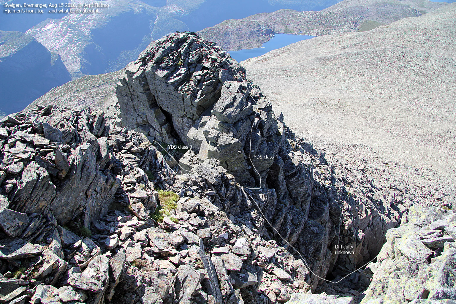
The easiest route to Hjelmen follows the normal route to Keipen (the highest peak in the Ålfotbreen region, except for the glacier high point) to Rundevatnet. From here, you go off-trail and negotiate a slab section and a few ledges before you ascend Hjelmen (on boulder) from the east. This page will also mention a round trip option that involves ascent from the west, which involves a short climbing pitch (YDS class 4) where you may or not may need a rope, and some exposed scrambling (YDS class 3). If climbing isn't what you're looking for, stick to the normal route.
Note that the easiest route also involves some scrambling of the easier sort, but only on the way up to Rundevatnet. The mountain calls for fit hikers, as the easiest route is more than 10km long (one way), and the vertical gain is more than 1000m.

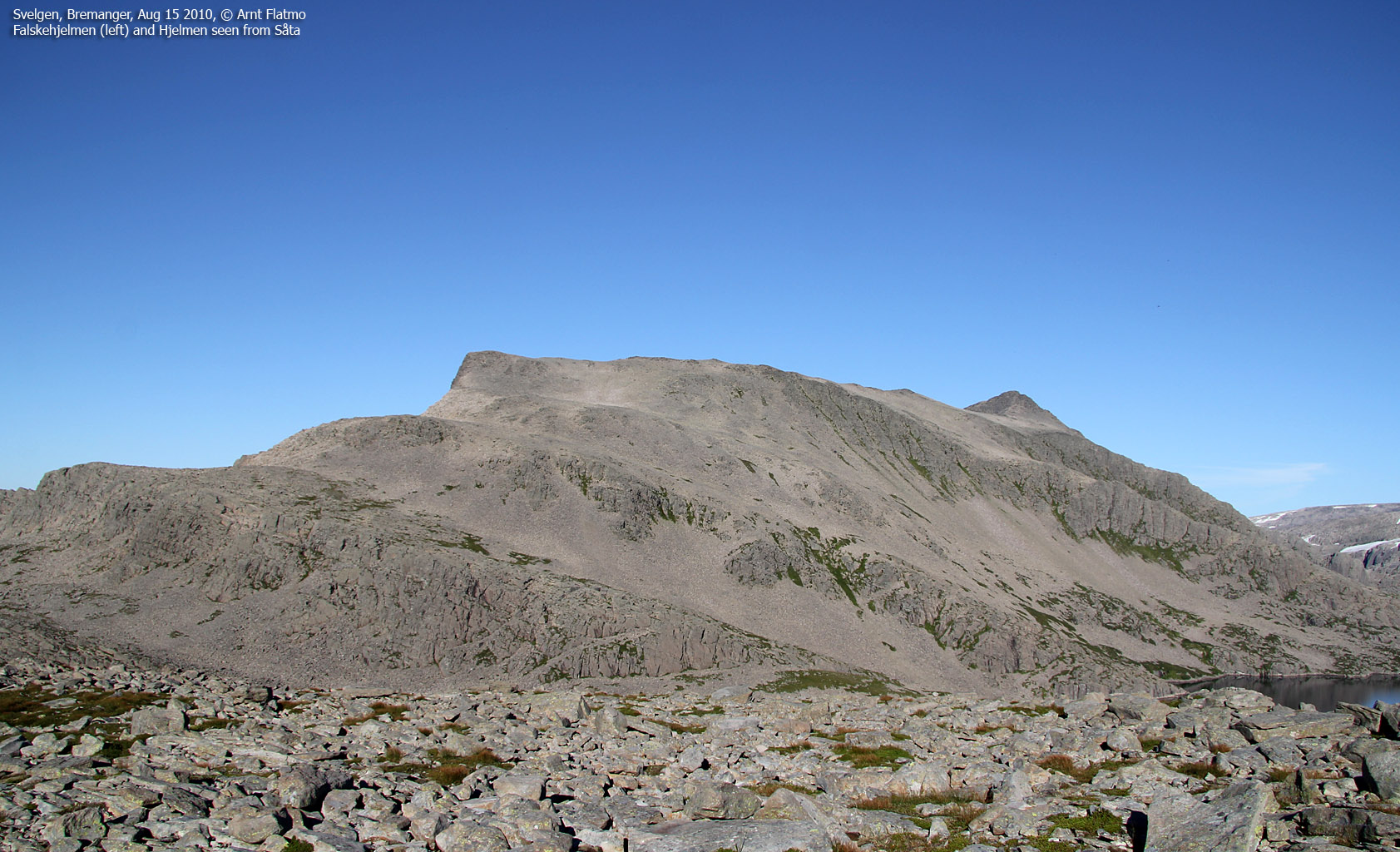
On your way along lake Søre Hjelmevatnet (726m (meters)), you can also visit Såta (840m), which offers a fine view towards Hjelmen.

Falskehjelmen and Hjelmen seen from Såta

(Click for larger image)
Hjelmen (Norge 1:50,000: 1215m, Økonomisk Kartverk: -, UTM 32 V 309617 6853454) has a primary factor of 385m towards the higher parent Keipen (1362m). The defining saddle (approx. UTM 32 V 310539 6852403) is found between west of Rundevatnet. Ref. Norge 1:50,000, the saddle is within the range 820-840m, interpolated to 830m.
GPS measurement read 1220m (on the summit cairn,<1m high), averaged over a 10-minute period (error margin +/- 1,7m)
Såta (Norge 1:50,000: 840m, Økonomisk Kartverk: -, UTM 32 V 307009 6853482) has a primary factor of 90m towards the higher parent Hjelmen. The defining saddle (approx. UTM 32 V 307590 6853539) is found just northwest of lake Søre Hjelmevatnet. Ref. Norge 1:50,000, the saddle is within the range 740-760m, interpolated to 750m.
GPS measurement read 844m (on the summit cairn,<1m high), averaged over a 3-minute period (error margin +/- 0,9m)

Google's interactive map. You can zoom, pan and click on the markers.
|
|
|
|
Route 1: Sørdalsvatnet - Hjelmen (summer/autumn)
|
|
Access
(all distances are approx. distances)
The starting point for this route description is Svelgen by the Nordgulen fjord in Bremanger. If you come from the north, you need to take a ferry from Stårheim to Isane and drive RV614 in the direction of Svelgen. Locate Lake Sørdalsvatnet (approx. 6,7km if you drive from Svelgen), and find a large parking area (N61.79399 E5.36374) alongside the road.
The route

Part of the ascent route from Sørdalsvatnet

(Click for larger image)
Walk along RV614 to the southwest end of the lake, then climb a staircase (Sørdalstrappa) which takes you onto the "T" path towards Keipen. Follow the forest path until you're back at the lake, then turn right when you see the Keipen signpost. Head up Søre Dalen to the Knekkevatn cabin (N61.77981 E5.34471). Continue southwest 500m until the path turns south and climbs up to Lake Søre Hjelmevatnet.
Continue up and down along Søre Hjelmevatnet (the path almosts passes the top of point 797m), then descend slightly and follow a ledge above Lake Vasskarvatna. The "dramatic" part of the route begins now. Follow the "T" route, well above Vasskarvatnet and in the direction of the Hjelmen - Keipen saddle. There are steep walls everywhere, and the terrain is rugged.
Descend to Lake Rundevatnet and find a place to cross the slab area to your left. Negotiate a number of shelves and continue (across boulder) to the top of Hjelmen (N61.76651 E5.39141).
Alternative ascent route (climbing):
As you top out on the meadow between Såta and Hjelmen, turn left (N61.76997 E5.34589) and find a convenient route up the long (yet easy) boulder fields. You top out near Falskehjelmen ("the false Helmet", 1094m) where you get a glimpse of Hjelmen summit. Proceed towards Hjelmen and you will see a distinct gap between the summit and a lower satellite top.
Scramble up to the satellite top, where you face two options; a) continue along the ridge and climb down to the gap (YDS class 4) or scramble around the satellite top on the south side (YDS class 3) towards the gap. If you can find a way into the cleft between Hjelmen and the satellite top, this might be the easiest way up to the gap.
Someone has built a "staircase" of rocks at the gap (a long time ago), allowing you to reach a solid handhold a bit higher up. Pull yourself up (YDS class 4) up to a small ledge, and scramble up to the summit.

 westcoastpeaks.com
 Other Sogn og Fjordane mountains
 Other Norwegian mountains