
Pawnee Peak, 3945m (12943 ft)Mountain area: Indian Peaks, Colorado USA Hiked: July 18, 2001 Maps: Nat'l Geographic #102 - Indian Peaks/Gold Hill Books:
|
 Pawnee Peak seen from Pawnee Pass trail |
Access (Long Lake Trailhead):
Please refer to the above books for more details and alternative routes
From Boulder, follow Colorado 119 westbound to Nederland, then Colorado 72 north to Ward. Immediately after Ward, turn left towards Brainard Lake Recreation Area. After a couple of miles, you have to pay a $5 fee at the fee station. Continue 6 miles past Brainard Lake to Long Lake Trailhead. If you're heading out a sunny summer morning, you could end up parking a good distance from the trailhead.
The trail:
From Long Lake trailhead, follow signs to Pawnee Pass, 4,25 miles from the trailhead. The first hour is easy forest trail until you reach lake Isabelle. At the lake, the Pawnee Pass trail starts switchbacking upwards. The trail profile is good for all hikers, allowing you to rest some while continue walking.
At the Pawnee Pass, you have Shoshoni Peak on your left and Pawnee Peak on your right. Leave the trail and walk up to Pawnee Peak the few hundred remaining feet.
Notes:
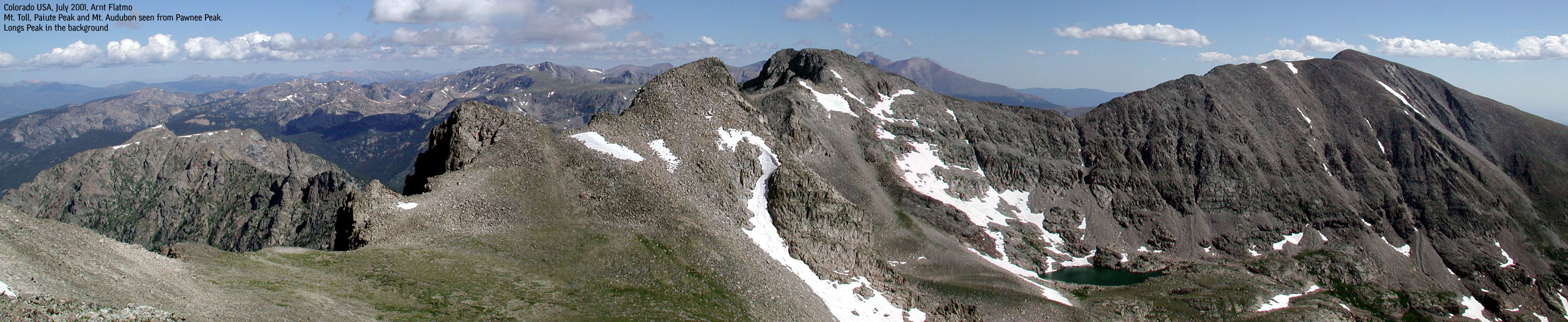
Mt. Toll (seen from Pawnee Peak summit) is a popular climb together with Pawnee. Walk down the north side of the mountain (avoid the snowfield) to the Toll foothills at 12,250 ft, and scramble up a talus to the top. I have not hiked this one myself, but it's said to be a class 2 hike. It looked steep from distance, though. Also, hiking Shoshoni Peak gives you 3 peaks on this day hike.
This was my fourth day in the Indian Peaks, and I had increased from Niwot (11,471ft), Saint Vrain (12,162ft) to Pawnee (12943ft). Still, sick as a dog while hiking down. The ambition to climb Toll and Shosoni faded as I reached Pawnee Peak summit.
I started from Long Lake TH at 7:20AM and reached Pawnee Peak at 10:00AM. I'm convinced I hiked in normal tempo. The hike down only took 1,5 hours, desperately wanting to get back to the hotel.
The views - even more spectacular than I expected. See the pictures. The Pawnee Pass trail is probably the most popular trail in the Indian Peaks. On a Wednesday july morning I met about 20 people on my way down to Lake Isabelle. And probably 20 more on the Long Lake trail.
Pictures: (move cursor to read notes, and click on the images to see full version)


Other trail descriptions for this region:
Links: