
Norwegian Mountains,
Nordland
|
| Fylke/Kommune : | Nordland/Vega |
| Maps : | 1726-1I Vega (Statens Kartverk, Norge 1:50 000) |
| Primary factor : |
Trollvasstinden: 804m Gullsvågfjellet: 529m Vikatinden: 160m Hestbaken: 111m |
| Hiked : | July 1996 (Trollvasstinden), July 2009 (Gullsvågfjellet), July 2010 (Vikatinden/Hestbaken) |
| See also : | Nordre Høyholmstindan |
| See also : | Søndre Høyholmstindan |
| See also : | De Syv Søstre |
| See also : | Dønnmannen |
| See also : | Other Nordland mountains on westcoastpeaks.com |

Vega mountains
(Click for larger image)
Vega island (and municipality) is situated approx. 20km northwest of Brønnøysund - a town on the sør-Helgeland coastline (Nordland county). The Vega Archipelago consists of 6500 islands, smaller islands and reefs, and is found on Unesco's World Heritage List.
The higher mountains are found on the west side of Vega island, Trollvasstinden (804m) being the highest. The other major mountain tops are Gullsvågfjellet (737m), Hestbaken (669m) and Vikatinden (661m). 1,8km west of Vega, you find Søla island, rising 432m above sea level. On the maps, you will see the name Vegtindan, located close to Hestbaken on Vikatinden, but according to locals, Vegtindan is the common name for all peaks on Vega.
You arrive on Vega via Igerøy, by ferry from Tjøtta (north) or Horn (south). Alternatively by a passenger boat from Sandnessjøen (north) or Brønnøysund (south). In summer, many tourists travel to the Ylvingen and Vega islands, and the ferry queues can be long. A good tip is to leave the car behind and bring your bicycle.

Vega mountains
(Click for larger image)
This page will describe a route from Bjørnlia to Gullsvågfjellet. A route to Trollvasstinden also begins at Bjørnlia, but is not described on this page (visited a long time ago, and recollection about the details is vague). None of the mountains have any difficult sections. Gullsvågfjellet is (probably) the most popular top, because of the short distance from the trailhead.

Trollvasstinden
(Click for larger image)
This page also describes an off-trail route from Myra to Hestbaken and Vikatinden. Although the route has no difficult sections, it is more suited for experienced hikers.

Vikatinden, Hestbaken and Trollvasstinden
(Click for larger image)
Trollvasstinden (Norge 1:50,000: 799m, Økonomisk Kartverk: 804m, UTM 32 W 629495 7281170) has a primary factor of 804m, being the highest point on Vega island.
Gullsvågfjellet (Norge 1:50,000: 737m, Økonomisk Kartverk: 737m, UTM 32 W 629946 7284269) has a primary factor of 539m towards the higher parent Trollvasstinden. The defining saddle (approx. UTM 32 W 629187 7282544) is found between these two tops - in Vegdalsskardet. Ref. Økonomisk Kartverk (5m contours), the saddle is within the range 205-210m, interpolated to 208m.
GPS measurement read 734m (on the cairn, ~2m high), averaged over a 5-minute period (error margin +/- 1,5m). This point is called Røsstinden on the map. Gullsvågfjellet (733m) is where the mast is - 370m northeast of Røsstinden.
Hestbaken (Norge 1:50,000: 668m, Økonomisk Kartverk: 669m, UTM 32 W 630494 7281063) has a primary factor of 111m towards the higher parent Trollvasstinden. The defining saddle (approx. UTM 32 W 630227 7281054) is found between these two tops. Ref. Økonomisk Kartverk (5m contours), the saddle is within the range 555-560m, interpolated to 558m.
GPS measurement read 669m (on the ground), averaged over a 5-minute period (error margin +/- 1,3m). On Økonomisk Kartverk, this mountain is also referred to as Vasstindan. The name Hestbaken is found on the Vikatinden side of the mountain ridge, but there is no doubt that Hestbaken is the mountain between Vikatinden and Trollvasstinden.
Vikatinden (Norge 1:50,000: 661m, Økonomisk Kartverk: 660,67m, UTM 32 W 632281 7281365) has a primary factor of 160m towards the higher parent Hestbaken. The defining saddle (approx. UTM 32 W 631278 7281170) is found between these two tops. Ref. Økonomisk Kartverk (5m contours), the saddle is defined as a fixed point - 501m.
GPS measurement read 662m (on the ground), averaged over a 5-minute period (error margin +/- 1,7m). This top is also referred to as Vegtinden on Økonomisk Kartverk.

Søla
(Click for larger image)
Google's interactive map. You can zoom, pan and click on the markers.
|
|
|
|
Route 1: Bjørnlia - Gullsvågfjellet / Røsstinden (summer/autumn)
|
|
This route description is valid per July 2009
Access
(all distances are approx. distances)
The starting point is Brønnøysund. Follow highway RV17 north (Sandnessjøen). Take the Horn - Vega ferry to Igerøy. Note that a ferry also runs to Anddalsvågen from Horn, so make sure you find the correct lane.
From Igerøy, follow highway RV839 towards Gladstad. Turn left towards Åsen (signposted). Continue 3,3km to the Rørøy junction (signposted). Turn right (straight ahead). Drive 1,5km to the junction near Breidablikk. Turn left and drive 1,3km up to the parking at Bjørnlia.
The route

The route to Gullsvågfjellet
(Click for larger image)
The path begins just before the gate in front of the gondola. The path forks very soon (next to a creek), but the two paths merge a bit higher up. The forest section can be somewhat strenuous, but you enter easier terrain in the valley higher up. You will (normally) find running water as you reach the valley.
From the valley, the path turns right (north) and leads up to a ridge. When you're below point 704m, the route changes direction to the southwest. Follow the markers (probably meant for snow vehicles) which take you on a detour around Gullsvågfjellet summit. Unless there is fog, you might just want to head straight up to Gullsvågfjellet. The final 100-150 vertical meters are boulder terrain.
From the mast (and the cairn) on Gullsvågfjellet, proceed 400m south/southwest to Røsstinden - also marked by a proper cairn. Return the way you came.
|
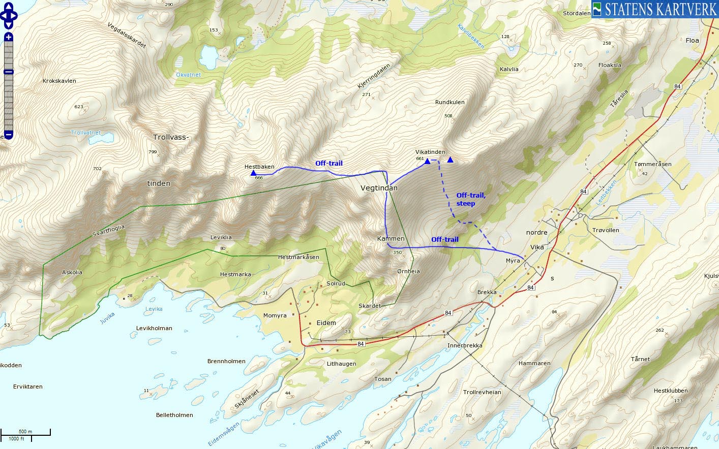
Route 2: Myra - Hestbaken - Vikatinden (summer/autumn)
|
|
This route description is valid per July 2010
Access
(all distances are approx. distances)
The starting point is Brønnøysund. Follow highway RV17 north (Sandnessjøen). Take the Horn - Vega ferry to Igerøy (N65.67743 E12.13152). Note that a ferry also runs to Anddalsvågen from Horn, so make sure you find the correct lane.
From Igerøy, follow highway RV839 towards Gladstad. After 9km, turn left (N65.66121 E11.98467) on the road towards Eidem. Drive 6,8km to Myra (N65.61692 E11.90077) and find parking where appropriate.
The route

Part of the route to Hestbaken
(Click for larger image)
Alternative 1:
Head west in the direction of Ørnheia (see the above picture). The terrain is a bit cumbersome before you get onto the Kammen ridge. Follow the ridge upwards and turn left towards Hestbaken when you arrive on the ridge crest. You'll have to descend 100 vertical meters before you can climb the 170 vertical meters up to Hestbaken (N65.62508 E11.83439) - marked by a small cairn.
On your way back, Vikatinden (N65.62707 E11.87344) is an easy top to reach. Also consider visiting Vikatinden's eastern spur (N65.62726 E11.87819 - approx. 640m). Vikatinden is marked by a medium-sized cairn.
Alternative 2:
Head northwest in the direction of Vikatinden (see the above picture) and aim for a distinct cleft. In this cleft, look for an easy scramble section on the left-hand side of the cleft. Once past this section, the rest of the hike up to Vikatinden is steep, but easy.

Vikatinden - Hestbaken round trip route
(Click for larger image)
 westcoastpeaks.com
Other Nordland mountains
Other Norwegian mountains
westcoastpeaks.com
Other Nordland mountains
Other Norwegian mountains


