
|

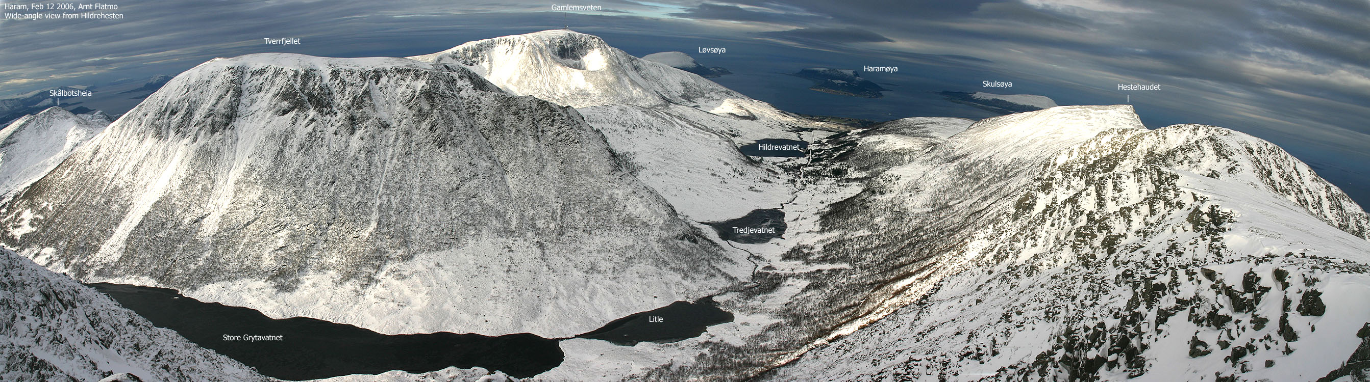
Tverrbotshornet is the 5th highest top in Haram kommune, located between Gamlemsveten and Hildrehesten. Tverrbotshornet is the high point on Tverrfjellet, a mountain with a fairly flat surface on top. The mountain can be ascended from the mountain service road that leads to Gamlemsveten. And while the most common route is (I only assume this) via the northwest ridge, the southwest ridge is more fascinating. This is the route described on this page. There are also routes that run from Hildre on the north side.
Although it gets more and more airy the higher you get on the southwest ridge, the ridge will seem safe for everyone with at least a slight head for heights. This applies to winter as well, unless large cornices make the ridge razor-sharp.
There are two cairns on Tverrbotshornet. The largest of these is a viewpoint cairn. The summit cairn is smaller. If you continue across the plateau, you will also find two minor cairns on Tverrfjellet high point.
Tverrbotshornet (M711: 749m, Ø.K.: 752,5 ~ 752m, UTM 32 V 363796 6938793) has a primary factor of 354m towards the higher parent mountain Gamlemsveten (791mm). The defining saddle (approx. UTM 32 V 363056 6939543) is found at Heiane, between the two mountains, and south of Lake Søvikvatnet. Ref. Økonomisk Kartverk (5m contours), the saddle is within the range 395m-400m, interpolated to 398m.
Notes: Class ratings are in reference to YDS. Click here for more information.
The trails described below are not necessarily the *easiest* trails to this mountain.
|
Søvik - Tverrbotshornet (all seasons)
|
|
Access
From Ålesund, follow highway E136->E39 towards Åndalsnes. From the E136/E39/Olsvika roundabout near Breivka, follow E39 approx. 13,3Km. Turn left onto highway RV661 (Skodje/Brattvåg/Vatne). After 1,5Km, pay toll at an unmanned toll booth (coins + credit cards + AutoPass). Approx. 9,7Km after you left E39, you reach the RV659 (Brattvåg)/661(Vatne) junction. Turn left here. Follow 659 4,3Km and turn left towards "Søvik/Grytastranda". Drive 14,4Km along this road and turn right when you see the "Sentrum" sign in Søvik.
Follow the main road 500m and turn 90 deg. left when you see a large, red barn on your right-hand side. You're now on the road to the trailhead. Stay on the main road for 600 more meters (you cross a creek along the way) until you reach a 3-way junction. Follow the middle road and follow the gravel road up to the trailhead (the road gate). Don't attempt to drive further, should the gate be open. You will find parking space just before the gate.
An alternative route from Ålesund is to drive via Ellingsøya. The Ellingsøytunnelen toll is (per Jan 2006) NOK 60,- (passenger cars, one person) thus, NOK 30,- more expensive than by driving E39.
The route
Follow the mountain service road towards Gamlemsveten up to 340m elevation. You will see a trailsign pointing towards Tverrbotshornet. I assume there is a summer path here, and that it leads to the northwest ridge. Just aim directly for the southwest ridge. You have to cross a stream from Heiane along the way, which should pose no problems. Next, gain the ridge and follow it to the top.
Descend your ascent route, or via the northwest ridge.


 westcoastpeaks.com
Other Møre & Romsdal mountains
Other Norwegian mountains
westcoastpeaks.com
Other Møre & Romsdal mountains
Other Norwegian mountains

