
|


Trolltinden (Troll Peak) is located on Ørskogfjellet and is one of the most characteristic mountains in this region. The mountain connects to Ytstetinden (1162m) via a sharp arete, and together with Remmemstinden, these tops form a beautiful mountain massif on the west side of E39 across Ørskogfjellet. The mountain was formerly known as Brustinden, and this name may still be used in certain areas.
Trolltinden also connects to Sandfjellet (905m) via another sharp arete. If you plan to ski Trolltinden, don't plan your ascent route across Sandfjellet. It would be wrong to classify Trolltinden as the ideal mountain for skiing. From Ørskogfjellet, you have to cross a large birch forest before taking on a very steep hill from the Trolltinden - Sandfjellet saddle. If the snowdepth is moderate, ice-axe and crampons may be the better choice up from the saddle.
The views are spectacular, and Trolltinden's primary factor is the highest in Vestnes kommune.
Trolltinden (M711: 1170m, Ø.K.: -, UTM 32 V 396066 6939727) has a primary factor of 857m towards the higher parent mountain Sprovstinden (1194m). The defining saddle (approx. UTM 32 V 394340 6935314) is found close to the county border and highway E39 on Ørskogfjellet. Ref. Økonomisk Kartverk (5m contours), the saddle is within the range 310m-315m, interpolated to 313m.
My GPS reported 1173m on the summit, averaged over at least 5 minutes.


Notes: Class ratings are in reference to YDS. Click here for more information.
The trails described below are not necessarily the *easiest* trails to this mountain.
|
This route is not suited for those who enjoy a smooth and easy ski-trip to the top of a mountain.
Bakkesætra - Trolltinden (winter)
|
|
Access
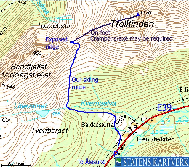
From Ålesund, follow highway E136->E39 towards Åndalsnes. From the E136/E39/Olsvika roundabout near Breivka, follow E39 40,2Km (passing the place Sjøholt along the way) and locate a small parking area on your right-hand side. Bakkesætra is located just down the road, on your left-hand side. Park here, or closer to Bakkesætra if you can find a convenient place to park.
The route
Ski from your trailhead towards Bakkesætra and overcome obstacles along the way (bush, forest, fences, etc). From Bakkesætra, follow Kvernelva river on the south side up to 400m elevation and then cross. The terrain so far is fairly open, but the birch forest becomes more dense up to 500m elevation below Sandfjellet. Switchback upwards and pick a route that you see fit.
Climb gradually up to the Sandfjellet - Trolltinden saddle. The route will become obvious along the way. The lower part of the ridge up to Trolltinden is not suited for average skiers, and unless the snow-depth is significant, you may be better off walking. If the ridge is icy, crampons/axe are very useful. From 950m elevation and upwards, the terrain is gentle. To reach the summit, you have to cross cornices. Make sure you stay on the safe side.
Descend your ascent route. Telemark skiers would probably (after checking avalanche conditions) carry their skis to the top and ski down Trolltinden's south side.


 westcoastpeaks.com
Other Møre & Romsdal mountains
Other Norwegian mountains
westcoastpeaks.com
Other Møre & Romsdal mountains
Other Norwegian mountains

