
Norwegian Mountains, Møre og Romsdal
Grøthornet via Eltraneset, Oct 18 2008
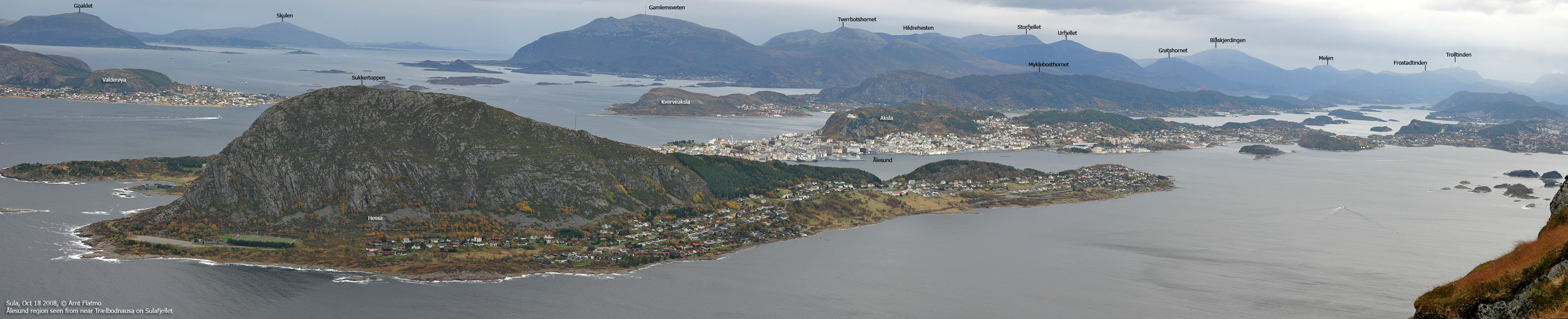
To the main Sulafjellet page.

The route up from Eltraneset
(Click for larger image)
This hike was the last item on my hikes-to-do-before-leaving-Ålesund list. Actually, it was the ridge up from Eltraneset (Eltrane) that was the driving factor. From distance, there was just no telling what this ridge would be like. On a windy Saturday in October, I decided to do the hike. I knew the hike would be long, but I had this clever idea about how to make it "shorter" - just walk fast.
There was no doubt it was gonna rain this Saturday. The only question was when. It was just overcast when I left home, and if I could just get to Eltraneset without getting soaked, I would claim that as a bonus. I already knew the trailhead, having walked the dog there earlier in the year. I left the trailhead 10:30am, and it was still not raining.

The north shore
(Click for larger image)
There is nothing much to broadcast from the hike to Eltraneset. An eagle kept me company, which was nice. I did the 5,5km hike in 1h:7m, and it was still not raining. The bonus was cashed in. But it didn't take me many seconds to conclude that I would not be going up the northwest ridge today. First of all, it was quite a bit steeper than I had imagined it to be. Then there was this wet, slippery grass which my worn-down boots wouldn't be happy on. I psyched out a bit, and wondered what to do. I felt raindrops. Should I turn around, or should I continue all the way to Sulesund and cross the mountain from there?
I chose to continue towards Sulesund. Perhaps I would find a way up along the way? After walking 800m, I was in a forest that didn't give me any view up the mountain. But then I noticed a boulder field. And sometimes, a boulder field provides access to higher ground. I figured; "what the h...", why not just check it out. The rain had made the rocks slippery, but this was of no big concern upon ascent.
I soon ran into some steep cliffs, which I got around on the right-hand side. I then discovered a vague track. Shortly after, I entered a couloir that would guarantee access to the upper plateau. I felt very good at this point. Moving up along the boulder in this couloir would be cumbersome, so I joined the ridge up to my left. Again, I ran into a vague track. This ridge was slightly airy in a few places, and I was thinking to myself that this was typical YDS class 2+ terrain. But the ridge led me safely up to the plateau and a cairn, and the time was now 12:43pm.

Parts of the route
(Click for larger image)
It was raining quite heavily by now, and I wondered if I should just skip Sulafjellet's high point - Vardane (778m). My foot had begun to ache. The inflammation had clearly not gone away. After ten minutes of walking, I was limping. Vardane was definitely out of the question. My only focus was to get down as fast as possible. I passed Langerabben (591m - the 581m map height is wrong!) before setting course towards Grøthornet (650m).
The rain was pouring down by now, and the fog swept across the island within just a couple of minutes. I passed across Grøthornet and took a direct route down to Blåfjellet. I had pictured a cumbersone descent from Blåfjellet, but discovered a path from the Reidarvarden cairn that took me down to Sandvika, just 670m east of the trailhead. I was back at the car 2:25pm, 3h:55m after leaving it. Taken the vertical gain into account, the hike was at least 16km. I drove home in my underwear ("undiken" as they, amusingly, say in Bergen) and a dry Gore-tex jacket.
To get to the Eltraneset trailhead outside Langevåg; From Ålesund, drive towards Sulesund, turn right towards Langevåg (signed), drive 800m, then turn right towards Langevåg (signed), drive 9,3km to the end of the road at Molvær (follow sign to Molvær in a Langevåg junction). Just before road end, turn right and follow a gravel road to the trailhead.


