
Norwegian Mountains,
Sør-Trøndelag
Strætasfjellet, 490m (Storvarden)
| County/ Municipality: | Sør-Trøndelag/Stjørdal | ||
| Maps: | 1621-I Stjørdal (Statens Kartverk, Norge 1:50 000) | ||
| Primary factor: | 182m | ||
| Hiked: | June 2013 | ||
| See also: |
| ||
| See also : | Other Sør-Trøndelag mountains on westcoastpeaks.com |

Strætasfjellet
(Click for larger image)
Introduction
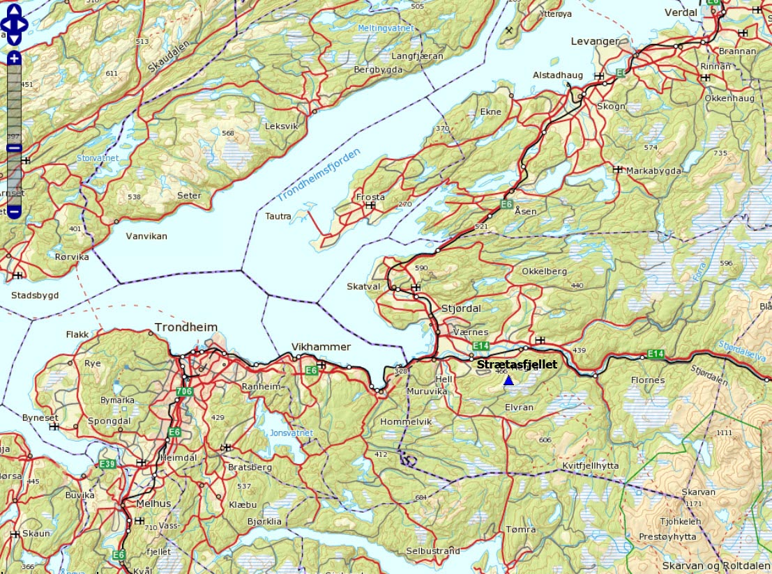
Strætasfjellet (also referred to as Strætesfjellet) is located southeast of the town Stjørdal in Sør-Trøndelag county. There is a military installation on the top. There are several routes to the high point, including a forest/mountain road leading all the way up. The mountain road passes through a shooting range, and the road is closed when the range is in use. This page will describe a marked path from Myrplassen at Sorte (Svorte). This is the most popular route to the top.

Trails in the local region
(Click for larger image)
Primary factor:
Strætasfjellet (Norge 1:50,000: -, Økonomisk Kartverk: high contour: 490 meters, UTM 32 V 603285 7034710) has a primary factor of 182m towards the higher parent mountain Klimpan (606m). The defining saddle (approx. UTM 32 V 606200 7034137) is found just southwest of Lake Flaksjøen. Ref. Økonomisk Kartverk (5m contours), the saddle is with the range 305-310m, interpolated to 308m.

Top of Strætasfjellet
(Click for larger image)
Google map
Google's interactive map. You can zoom, pan and click on the markers.
|
|
Route descriptions
| This disclaimer is regarding all of the literature and instructional guides posted on the westcoastpeaks.com website. These instructions are guidelines only, and should not be used in lieu of common sense or judgment when attempting any of the actions involved or instructed. Westcoastpeaks nor myself will not be liable nor will it indemnify any form of compensation to anyone who has injured, harmed or even killed themselves or others while following any of the instructions written within the website. It should be noted by any persons willing to undertake any of the instructions provided that mountains offer varying levels of risk, regardless of size or incline. Risks to be considered are as follows but not limited to: wild animals, weather, the terrain, bad judgment, inappropriate or insufficient equipment, improper training or experience and of course, bad luck... |
|
Route 1: Myrplassen - Strætasfjellet
|
|


This route description is valid per June 2013
Access
(all distances are approx. distances)
This route description begins at Stjørdal, east of Trondheim. From E6 Follow signs towards highway RV705 (Selbu) and you arrive at a roundabout (N63.45124 E10.91563). From here, drive as follows;
- Drive 350 meters south to another roundabout (N63.44836 E10.91449). Go straight through.
- Cross the Stjørdalselva river on a bridge
- Turn right onto highway RV705
- Drive under the bridge and continue east on 705.
- Drive 0,8km, then turn left. Signposted "Hegra". N63.44408 E10.92381.
- Drive 2,6km, then turn right. Signposted "Sorte". N63.44514 E10.97088.
- Drive 3,3km, then turn right (approx. 0,5km after Ekra Gård). N63.43536 E11.02620
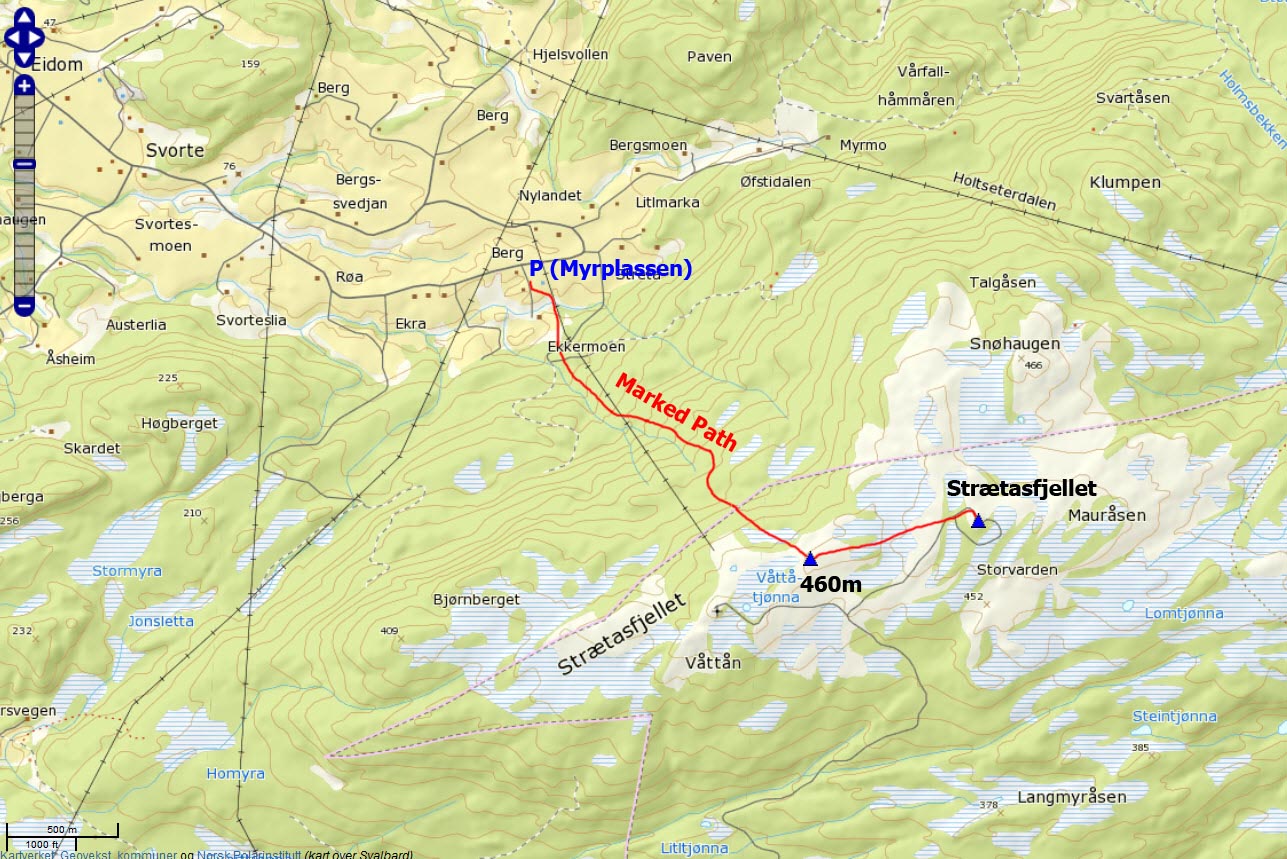
- Drive into "Myrplassen" and find parking here (N63.43459 E11.02772)
The route:

The route, as seen in Google Earth
(Click for larger image)
Look for the "Tursti" signpost on the southwest side of Myrplassen. From here;
- Follow a marked and visible path 0,4km
until you reach an intersecting forest road (N63.43202
E11.03040)
- Continue 70-80 meters to the south,
and you will see a "Gapahuk" at
Våggåskiftet. (N63.43150 E11.03040).
- Follow the marked path (signposted "Strætesfjellet")
1,7km up the forest until you reach
a signpost
marked "Strætasfjellet" at 460 meters (N63.42366
E11.05436). This is not the high point! The upper part of the path is
boggy
after rain.
- From the cairn, you can
follow cairns
(painted in blue) to the
high point (N63.42589 E11.06955). You
will join the mountain road which loops around the
top. Take the left side. There are
two cairns - one on each side
of the fence that is meant to protect the building on top from
intruders. Interestingly enough, the largest cairn is on the
inside of the fence...
Comment: Halfway between the 460m cairn and the top, we lost faith in that the cairns would take us to the high point and we aimed for the mountain road and followed it to the top. But from what we have learned afterwards, the cairns do lead to the high point.

No reason to get lost...

(Click for larger image)
 westcoastpeaks.com
Other Sør-Trøndelag mountains
Other Norwegian mountains
westcoastpeaks.com
Other Sør-Trøndelag mountains
Other Norwegian mountains