
Norwegian Mountains, Møre og RomsdalStorgrovfjellet, 1629m

Storgrovfjellet seen from Breitinden
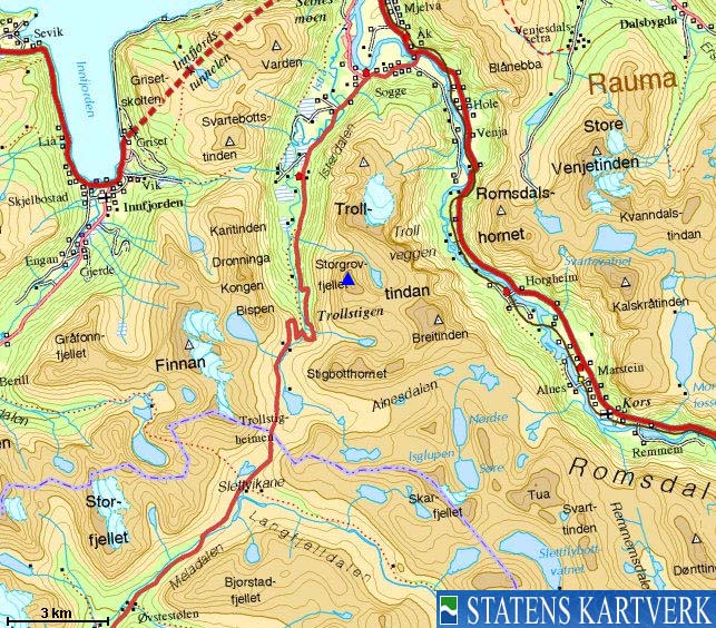
IntroductionStorgrovfjellet rises steep up from the Isterdalen valley in the west and connects to Søndre Trolltind/Semletind above Romsdalen valley in the east. The normal route begins at Stigrøra, the popular viewpoint on top of the famous Trollstigen road (one of Norway's most popular tourist attractions). Storgrovfjellet is a classic mountain for summer-skiing, and the prime visiting period is between the opening of the Trollstigen road (May-June) and before the snow in Stigbotnen valley has melted away. In other words, the visiting hours are short. Should you run into people on Storgrovfjellet, it is likely that they are seasoned summer skiers in the Trollstigen area, and that they are already very familiar with the more attractive mountains, such as Alnestinden, Finnan and Breitinden. Visiting Storgrovfjellet is the summertime poses no difficulties other than boulder. Storgrovfjellet is also a first class viewpoint towards the Trolltindane - Breitinden massif. Primary factor:Storgrovfjellet (Norge 1:50,000: 1529m, Økonomisk Kartverk: -, UTM 32 V 432962 6927492) has a primary factor of 299m towards the higher parent mountain Breitinden (1797m). The defining saddle (approx. UTM 32 V 434297 6926842) is found between the two tops. Ref. Norge 1:50,000 (20m contours), the saddle is within the range 1320-1340m, interpolated to 1330m. Personal GPS measurement on top of the Storgrovfjellet cairn read 1630m (1m error margin), as average over 10 minutes. The spring snow of 2008 measured approx. 1m higher, and below is rock higher than the base of the cairn.
Google map
Google's interactive map. You can zoom, pan and click on the markers.
Trail descriptions
Notes: Class ratings are in reference to YDS. Click here for more information.
The trails described below are not necessarily the *easiest* trails to this mountain.
Access (all distances are approx. distances) Note: The Trollstigen road is open between late spring and late autumn. Check this link for road info. From Ålesund, you can drive to Trollstigen via E136 to Åndalsnes, then southbound to the RV63 Trollstigen junction and then up the Isterdalen valley. Or; follow E39 to Sjøholt (29Km from Breivika), turn right towards "Stordal/Geiranger" and continue along Norddalsfjorden on RV63 to the place Sylte (45Km). Turn north and follow RV63 to the top of Valldalen (Alnesreset) and then down to the parking above the Trollstigen switchbacks (34,5Km). The route 
The route to Storgrovfjellet
Follow a path leading towards the river(s) from Lake Stigbottvatnet. This path runs higher than the path leading to the tourist viewpoint. Pick a line with consecutive snow up along the river. If the hill becomes too steep for you, seek towards the river. You'll need to cross the river on snow bridges.
Once in Stigbotnen, pick a line in the direction of point 1464m
and then follow Storgrovfjellet's southeast ridge to the top. Note that you'll
pass a false top before you reach the summit. Storgrovfjellet's wide
south flank
will give you a good run down on skis.
Pictures and Trip reports:
|


