
For Information, maps, trailhead and route descriptions, click HERE.
I decided to invite a number of colleagues for a hike across Bergetindane. 3 had the opportunity this Tuesday evening; Torill, Terje and Olav. I had been on hikes with all of them, and Torill was my climbing mate on Romsdalshorn. Olav had been to Romsdalshorn as well, and Terje is a "fast-lane" guy, doing all sorts of crazy stuff, ski-jumping included. The group consisted of people having been in steep terrain before, and with a general desire to seek new challenges.
I had hiked Bergetindane solo in June, and strongly "felt" my precense on this mountain. I was alone, I didn't quite know what was awaiting, and the mountain was wet and slippery. I felt a very strong focus on that hike. My previous trip report ended with "Should I do it again, I would traverse the ridge swiftly, knowing where to go and what to do, and without skipping heartbeats along the way". This turned out to be very true. The second hike is completely a different thing.
The hike
After leaving Torill's car at Reme, we headed out from Helland school 16:50PM. The forecast promised good weather, but the Haram mountains were swept in fog. I didn't mind much. I expected the rock to be dry, and the fog to create nice contrasts in the pictures. The pace upwards was steady, and we didn't take any long breaks. Some of us got temporarily busy with some rock scrambling on the ridge up to Bergetindane, but got, eventually, back on track.
When we arrived the pole, the first narrow point on the ridge, I got confused. I could swear I was scrambling here on my last hike. Now, we were simply walking across. Based on my previous trip report, the expectations in the group were "high", and I strongly wondered how the rest of the hike would be.
The next point of interest was "the bridge". I clearly remember my low gravity on this ridge, primarily because of the wet and slippery rock, and that I was happy to get off this bridge, half-way across. But today, walking straight across felt like the easiest thing in the world. I can only speak for myself (and Terje, of course) but it didn't seem like Torill and Olav were bothered with the route or the exposure. Focused, I'm sure. After all, this was their first time on this route. But not seemingly bothered.
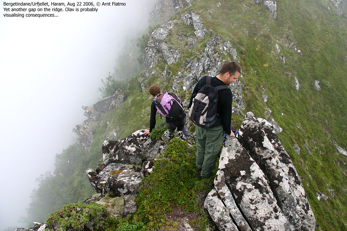
I felt a bit embarassed at this point, as the route didn't seem to offer any noteworthy challenges to anyone. I guess the others had pictured a much harder route, based on my previous trip report, and how I had described the route. But it was nevertheless a very fun hike. I was most curious about the "crux" point of the route, where my attention level was at all-time high upon my last visit. I thought to myself - Terje will arrive the crux point, just jump across and give me the "was this the hard part?" look. And guess what... Once he was down, I lowered my camera to him, then he climbed down the ridge and was sitting on a turf, high across on the other side, before I could say b-e-e-r.
Torill was next in line, and chose a different method for getting across. She wanted to stretch out and slide into the gap. This concerned me, as she would expose herself more in case of a unforseen problem. I mounted a long sling, not for her to use, but as a lifeline in case something should go wrong. I had brought along equipment for belay, but the others didn't feel this was necessary. Torill and Olav passed this point swiftly and were already descending down from the ridge by the time I had jumped across and retrieved the sling. I had now descended this awkard section of the ridge on both sides. Clearly, jumping was the easiest way.
We had now completed the roughest part of the ridge. The rest of the route had zero exposure, as we could walk alongside the ridge crest. However, we chose to extend the FUN as long as possible. We arrived the summit 19:15PM and waited around 15 minutes, hoping the sun would break through. We had blue sky above, the sun was "lurking" behind the fog, but the fog never let go. We descended towards Reme, and arrived Torill's car 20:35PM. The original plan was to descend via Ringstaddalen, but the Reme route offered more path and a COMPLETE traverse of the mountain.
It was a very fun hike, well suited for people who have been around terrain like this before. While the "technical" challenges are few, good balance and a head for height is a must. The exposure is significant in parts of the route. Those who get dizzy from heights, should NOT attempt this route. On wet rock, this route is a altogether a different story...
Map: We followed routes 5A and 3 on this trip

To Bergetindane


Towards the "crux"


The "crux"


Final section of the ridge


Summit and descent


No Javascript:
1 2 3 4 5 6 7 8 9 10 11 12 13 14 15 16 17 18 19 20 21 22 23 24 25 26 27 28 29 30 31 32 33 34
 westcoastpeaks.com
Other Møre & Romsdal mountains
Other Norwegian mountains
westcoastpeaks.com
Other Møre & Romsdal mountains
Other Norwegian mountains