
|


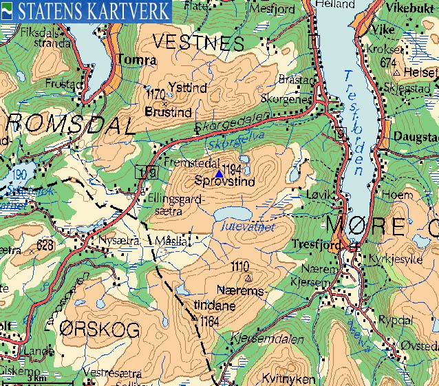
Sprovstinden is located on Ørskogfjellet and is the highest mountain on the mainland north of the Vagsvika - Tresfjorden road, and is a landmark (together with the Trolltinden - Ytstetinden massif), especially when seen from Ålesund in the west. Sandtinden is one of Sprovtinden's satellite tops, and two ski-lifts and a couple of downhill slopes are found at Sandtinden's foothills.
This web-page describes a route that runs up the downhill slopes, which works well when the slopes are closed. Alternatively, start at the main Ørskogfjellet parking area and ascend Sprovstinden via Varguraksla. Sprovstinden can be reached on skis without any particular steep and exposed parts, but because of a rocky terrain, you need a good amount of snow before you can "let yourself go" upon descent.
The views are phenomenal, as Sprovstinden's primary factor is among the 35 highest in Møre and Romsdal county.
Sprovstinden (M711: 1194m, Ø.K.: 1193,96m, UTM 32 V 398374 6936733) has a primary factor of 821m towards the higher parent mountain Kvitnyken (1244m). The defining saddle (approx. UTM 32 V 398607 6927815) is found at the north end of Lake Kjersemvatnet along the road between Vagsvika and Tresfjorden. Ref. Økonomisk Kartverk (5m contours), the saddle is within the range 371-375m, interpolated to 373m.
On the maps, it seems that Lake Kjersemvatnet drains both north and south. It drains south, while a stream from Litlebotnen passes the lake 60m further east. A branching creek from this stream drains down to the lake. The saddle has to be at the point of the branch. In other words, on your way from Sprovstinden to Kvitnyken, you have to cross running water (a less typical scenario).
Sandtinden (M711: 1065m, Ø.K.: 1065,26m, UTM 32 V 397157 6936434) has a primary factor of 55m towards the higher parent mountain Sprovstinden. The defining saddle (approx. UTM 32 V 397534 6936566) is found on the ridge between the two tops. Ref. the 1220-II map (20m contours), the saddle is within the range 1000-1020m, interpolated to 1010m.
Notes;


Notes: Class ratings are in reference to YDS. Click here for more information.
The trails described below are not necessarily the *easiest* trails to this mountain.
|
Ørskogfjellet Alpinanlegg - Sandtinden - Sprovstinden (winter)
|
|
Access
From Ålesund, follow highway E136->E39 towards Åndalsnes. From the E136/E39/Olsvika roundabout near Breivka, follow E39 38,7Km (passing the place Sjøholt along the way). Turn right towards "Skitrekk". If the road to the downhill slopes has not been plowed, there are (most likely) turn-outs along the road.
The route
Assuming there is downhill traffic in the slopes, head up the widest slope, which makes a left turn at 530m. Proceed up towards the upper ski-lift (700m elevation), and set an eastern course before you reach the ski-lift. Continue on a long traverse up to 760m elevation where you turn left and head up Sandtinden's south ridge. Find your preferred route up to Sandtinden. You will find a number of cairns here. The highest point is obvious.
From Sandtinden, descend approx. 55m to the ridge that connects the two tops, and find your preferred route up to Sprovstinden. No cairn marks the top. Be aware of cornices and stay on the mountain! Descend your ascent route. I *assume* that Telemark skiers would descend southbound from the Sandtinden - Sprovstinden ridge, in the direction of Jutevatnet, and then curve along Varguraksla on the way back to the main road. But this is only my assumption.


 westcoastpeaks.com
Other Møre & Romsdal mountains
Other Norwegian mountains
westcoastpeaks.com
Other Møre & Romsdal mountains
Other Norwegian mountains

