
Norwegian Mountains, Møre og Romsdal
Sandegga, 1389m
| County/Municipality: | Møre og Romsdal county/Volda & Ørsta municipality | ||||||||||
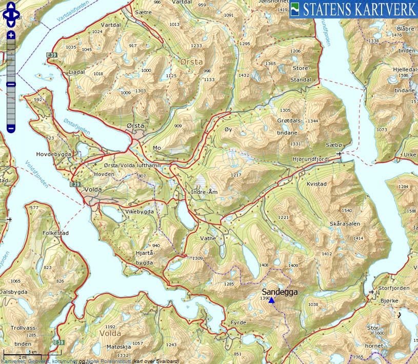
| Maps: | 1219-III Hjørundfjord (Statens Kartverk, Norge 1:50 000) | ||||||||||
| Primary factor: | 239m | ||||||||||
| Hiked: | Apr 2012 | ||||||||||
| See also: |
| ||||||||||
| See also : | Other Møre og Romsdal mountains on westcoastpeaks.com |

Sandegga
(Click for larger image)
Introduction
Sandegga is found on the Ørsta/Volda municipality border and belongs to the mountain region defined by Bondalen, Skjåstaddalen and Austefjorden. The mountain has 3 summits; 1389m is the south top and is normally ascended from Langvatn by Austefjorden (this is the route described on this page). Point 1387m is found 250 meters to the northeast. This top - and the the north top (1345m) is normally ascended from Skjåstadsætra. At the present, this site has no knowledge about the summit ridge across the three tops, or the ridge connecting to Storetinden (via point 1216m).

Sandegga
(Click for larger image)
The route from Langvatn is used both as a hiking route and spring skiing route. There is avalanche danger from Sandegga's south face (Neshornet) as well as from the slopes below Langvassætra. These slopes are also dangerous if the snow is hard. In this case, ice-axe and crampons might be required. In addition, point 1389m has dangerous cornices. Be very aware of the snow conditions on this mountain!

The route from Langvatn to Langvassætra
(Click for larger image)
Primary factor:
Sandegga (Norge 1:50,000: 1390m, Økonomisk Kartverk: 1389m, UTM 32 V 363971 6886802) has a primary factor of 239m towards the higher parent mountain Storetinden (1408m). The defining saddle (approx. 32 V 365132 6888188) is found between point 1216m and point 1363m. Ref. Norge 1:50,000 (20m contours), the saddle is within the range 1140-1160m, interpolated to 1150m.

The two main summits
(Click for larger image)
Google map
Google's interactive map. You can zoom, pan and click on the markers.
|
|
Trail descriptions
| This disclaimer is regarding all of the literature and instructional guides posted on the westcoastpeaks.com website. These instructions are guidelines only, and should not be used in lieu of common sense or judgment when attempting any of the actions involved or instructed. Westcoastpeaks nor myself will not be liable nor will it indemnify any form of compensation to anyone who has injured, harmed or even killed themselves or others while following any of the instructions written within the website. It should be noted by any persons willing to undertake any of the instructions provided that mountains offer varying levels of risk, regardless of size or incline. Risks to be considered are as follows but not limited to: wild animals, weather, the terrain, bad judgment, inappropriate or insufficient equipment, improper training or experience and of course, bad luck... |
|
Route 1: Langvatn - Sandegga (all seasons)
|
|


This route description is valid per Apr 2012
Access
(all distances are approx. distances)
The starting point for this route description is the town Volda on Sunnmøre.
From Volda, follow the road along Austefjorden towards Fyrde/Austefjord. As this is written, the Kvivsvegen road is under construction, so the road description is for the moment a bit vague. Once you have passed the two exits towards Fyrde (the new road runs north and outside of Fyrde/Austefjord), drive approx. 1,3km and turn left (N62.06177 E6.36946) towards Solsida (the old road - and signposted). Drive 0,9km and turn left on a gravel road (N62.06022 E6.38485 - not ploughed in winter). Continue this (rough) road 0,3km up to a parking area (N62.06210 E6.38807).
The route:

The route, as seen in Google Earth
(Click for larger image)
From the parking, walk towards a gate by the nearest creek. Go through the gate and follow a path 0,2km to the east (don't cross the creek!) before the path turns northeast and runs upwards between the two creeks coming down the mountain. The path is vague and may be very hard to see in places. Moreover, avalanches may make forward progress difficult in the lower section. Expect to look for the route in places, and in worst case - use your hands to negotiate obstacles like small cliffs. Once you pass 400 meters, the obstacles are history and it's a straightforward hike up to Langvassætra (N62.06852 E6.40298) at 676m.
From the cabins, head northeast until you reach the Sandegga - Langvasshornet ridge. Turn left (northwest) and follow the ridge upwards. The summit point may be difficult to reach in winter because of cornices. Think twice before you decide to challenge mother nature...

The route from Langvatn to Sandegga
(Click for larger image)
Pictures and Trip reports:
- Sandegga on skis, Apr 22 2012 (w/Anne)
- Sandegga seen from other mountains
 westcoastpeaks.com
Other Møre og Romsdal mountains
Other Norwegian mountains
westcoastpeaks.com
Other Møre og Romsdal mountains
Other Norwegian mountains