
For Information, maps, trailhead and route descriptions, click HERE.
Weather...
On the day, three months after visiting Kolåstinden, the time had come to visit Romedalstinden. The decision came late; I have the greatest neighbour in the world. He called me late the evening before; "Gorgeous day tomorrow. I'll look after your dog, so you can climb a fine mountain". I got up reasonably early the next morning, ate breakfast, minded the dog and headed out.
The "gorgeous day" turned out to be a very, very foggy day. Now what, I wondered, while driving towards Solavågen and the ferry. I called a friend who was on the way to Elsandtinden, and learned that Stranda has gorgeous weather. I assumed, and hoped, that this fog would lift, but it wasn't just THAT KIND OF FOG, either. I ended up on the 09:20AM ferry to Festøya, still very confused about how the day would be. I wondered if I should go inland. I called a friend in Ørsta, but was told that Ørsta was "all fogged in".
Great start...
I parked at Ytre-Standal and ran an equipment-check. Not too bad. Only food and map were missing. But I had gaiters! I wondered when I last used them. I switched on the GPS to get to know the territory. The small display isn't always easy to read, but I learned that if I wanted to go to Molladalen, I should be on the north side of the river, and otherwise, on the south side. I was jealous on the gravel road that seemed to go quite far - on the NORTH side of the river. On the south side, I could only drive 200m.
Fair enough, I had plenty of time, waiting for this fog to lift. I headed out 10:05AM and was a bit surprised when all I could find, was an overgrown, faint path. The (high) grass was all wet, and the gaiters came on pretty fast. The path wasn't difficult to follow, but there was something strange about it all.
10:30AM, the path ended and I was standing in front of the river. On the other side, I could see a road!! I looked at the GPS, this time with a finer comb, and wrote a large mental note; PREPARE BETTER. Next job was to get across the river. It took about 10 minutes, but I managed without falling in, or otherwise getting more wet than the grass had caused. On the road, I turned a bend, and there was a bridge...
Where's the path?
By the time I passed Ytre-Standalsætra 11:00AM, I was in fog-land. But a trailsign and a T-trail lifted my spirit. But then I noticed "Molladalen" on the trailsign, and concluded that I wasn't so lucky after all. I left the trail, and headed down to the river from Litlekoppen. This was no fun terrain at all. Large rocks, dense bush, and it was almost impossible to walk down there. While being a bit frustrated, it suddenly dawned on me that the trailsign had said something else too. Did it say "Standalhytta" ? I looked at the GPS, but there was no path towards Standalshytta. I had to conclude that there was a trailfork higher up. I decided to head through the forest, join the trail and see what happened next.
After a minor bush-war, I followed the trail up to 440m elevation, and the "red light" was now flashing. I was clearly on my way to Molladalen. And what was I to do in Molladalen in this fog? I decided to break through the forest and get back to the river. I had a feeling that Romedalstinden was slipping, but at least I got to learn the territory...
After a rather tiresome fight through the forest, I stumbled onto something that very much looked like a path! And then I heard voices. Ingunn, Tor and Terje from Ørsta were also on their way to Romedalstinden. I asked where the h... this path began, and they told me. Although the trailsign had fallen down, I should still have seen the path! Enough of this amateur business. Time to focus.
Where's the col?
The time was now 11:40AM, I joined their group, and we were obviously heading the right way. Twentysome-minutes later, nothing short of a miracle happened. We could see mountains! At 500m elevation, we rose above the sea of fog that covered Hjørundfjorden (and the ocean as well) and had Romedalstinden straight ahead of us.
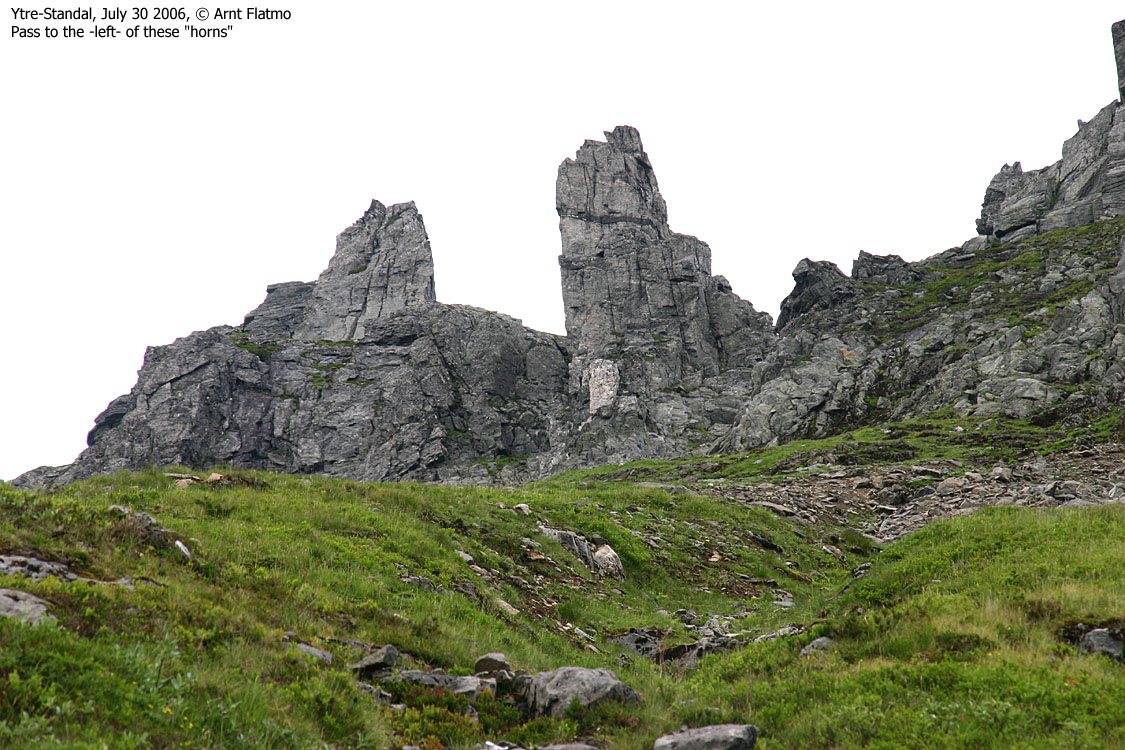
High in the hillside towards Romedalstinden, below two distinct "horns", we discussed where we should ascend the ridge. My point of view was that we should maintain our course, but the other route was short, and it wouldn't be time-consuming to check it out. Reaching the ridge, which would be the southeast ridge of Storkopptindane, didn't give the right answers. People had obviously been up here. While Terje scrambled the ridge to get a better look, I went around on the back side. After a few minutes, I headed down and told the others that I wanted to proceed on our previous course.
I realised that this was loose-rock country and tried to move as weightless as I possibly could. That didn't stop from releasing a rock of a size of a football, and painfully, I watched it fall and fall, repeatingly causing other rocks to fall along with it. The "upside" was that the rocks headed into ditches, causing them to end up in a large slab area above the lake. It was rather unlikely that people would be down there, and I hope the sheep had enough wisdom to stay furhter into the valley. I didn't actually step on the rock, but soft ground gave way, and released the rock. I couldn't see it coming, and decided not to slap myself for missing focus.
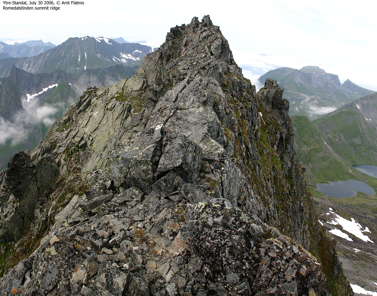
13:40PM, I topped out on the col, proceeded along the ridge, whistled down towards the others (resting at the wrong col), found the route around the pinnacle and headed up to the front top. I was very well aware of the summit ridge, and had decided (long ago) that once up here, I should be equally bold as the old man in the "Fotturar" book. The ridge was to be walked upright! That went surprisingly easy, and by 14:05PM, I was standing on Romedalstinden summit.
The others
I decided to wait around for the others. I took a lot of pictures and then headed back to the front top, to see how they were doing. I descended yet some more, for some more pictures. The others arrived, and I went back up to the front top along with them. I knew well that the summit ridge pictures would be more fun with people on the ridge. Ingunn chose to wait by the front top, while Tor and Terje headed across. I followed them to get a picture close to the one in the book. Terje looked as if a head for heights was given to him at birth.
"The others" were very nice people and we chatted for a good while. I was treated with coffee and offered sandwiches. They took pity in me, as I hadn't brought food. But I wasn't all that hungry, and declined.
Descent
Time was "flying", and I suddenly started thinking about my dog and the neighbour. I parted with the others and left the mountain 15:40PM. I managed to descend the long hillside rather fast, but without causing more rockfall. But the descent put the feet "on fire", and every step down the valley, was painful.
The fog had now lifted, and I could fully enjoy the beautiful valley. A group of afternoon hikers were reaching Ytre-Standalssætra as I passed it, and then it began to rain. I attempted to run, but my feet wouldn't let me. I could have sworn that smoke came out of my boots. But the rain stopped and the sun was shining again. I tried to have merry thoughts as I passed the upper parking, knowing my car WASN'T THERE. But 17:10PM (after having jumped the river), I was back at the car. I decided to postpone changing boots until I reached the ferry, which (of course) left one minute prior to my arrival. Well, now I had 30 minutes to change the boots, and plenty of time to think back on Romedalstinden.
To Litlekoppen


To the Romedalstinden - Storkopptindane col


To the summit


Near-360 deg. wide-angle panorama

360 deg. 50mm panorama, 2 parts


Misc. views from Romedalstinden


Romedalstinden summit ridge (the Ørsta group)


Descent


No Javascript:
1 2 3 4 5 6 7 8 9 10 11 12 13 14 15 16 17 18 19 20 21 22 23 24 25 26 27 28 29 30 31 32 33 34 35 36 37 38 39 40
 westcoastpeaks.com
Other Møre & Romsdal mountains
Other Norwegian mountains
westcoastpeaks.com
Other Møre & Romsdal mountains
Other Norwegian mountains