
|


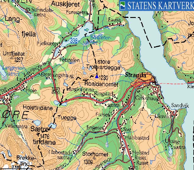
Roaldshornet is a very popular mountain, located east of the place Stranda. A ski-lift runs almost to the top of the mountain, so the mountain is busy all year around. The mountain is known for its good views, and can offer all sorts of routes for hiking and skiing. A traverse of the mountain is recommended, providing you can arrange transportation back to the trailhead.
This web page describes one of the fastest summer routes to the mountain top - up along the ski-lifts, as well as the popular route from Svartevatnet, across Kleivdalsfjellet. Another route runs from Skurdavatna across Trollvardegga and Blåfjellet. Refer to the Skurdahornet page for description of the route from Stranda to Skurdavatna.


Roaldshornet (Norge 1:50,000: 1230m, Ø.konomisk Kartverk: 1230,10m, UTM 32 V 388004 6910781) has a primary factor of 697m towards the higher parent mountain Ytstevasshornet (1330m). The defining saddle (approx. UTM 32 V 384249 6908572) is found north of Lake Svartevatnet. Ref. the Økonomisk Kartverk map (5m contours), the saddle is within the range 530-535m, interpolated to 533m.
Personal GPS measurement averaged the elevation to 1233m, over a 20-minute period. The GPS was located on the ground, and the GPS accuracy was not recorded (bummer..)
Notes: Class ratings are in reference to YDS. Click here for more information.
The trails described below are not necessarily the *easiest* trails to this mountain.
|
Route 1: Strandafjellet Skisenter - Roaldshornet (summer/autumn)
|
|
Access
From Ålesund, follow highway E39 towards Bergen, and then highway RV60 (Stranda) to the Magerholm - Ørsneset ferry (approx. 8Km). This ferry runs quite often; every 20 minutes in the busy hours of the day. From Ørsneset, follow RV60 (Stranda) approx. 30-31Km to Strandafjellet Skisenter parking area (left-hand side of the road)
The route
From the parking area, cross the river on a bridge and head up along the lower ski-lift. In the beginning, follow open space and then stay with the Roaldstrekket ski-lift upwards. A vague path indicates that some do follow this route. Near the end of the lower ski-lift (approx. 850m), move west (left) towards the upper ski-lift (Roaldshorn Fjelltrekk) and follow this to the end at approx. 1170m. A path runs up along this ski-lift, further to the west. From the top of the ski-lift, follow path west of the hump above the ski-lift and continue across rocky terrain up to the summit.


|
Route 2: Svartevatnet - Kleivdalsfjellet - Roaldshornet (summer/autumn)
|
|
Access
From Ålesund, follow highway E39 towards Bergen, and then highway RV60 (Stranda) to the Magerholm - Ørsneset ferry (approx. 8Km). This ferry runs quite often; every 20 minutes in the busy hours of the day. From Ørsneset, follow RV60 (Stranda) approx. 25,2Km to the parking area (right-hand side of the road) on the highest road point on Strandafjellet.
The route
Head 250m to the southeast and locate the signed trail to Roaldshornet. The trail climbs gently to Langevatnet (850m) where you turn left (signed "Roaldshornet"). Don't follow the vague path along the lake. The trail climbs higher up to the left. The ground may be a bit boggy up to this point.
The trail gradually turns into a path, the higher you get. You pass Kleivdalsfjellet 200m southeast of the high point. Make an off-trail visit to the Kleivdalsfjellet cairn, and get back en route to Roaldshornet.
The path (still visible) follows the ridge westbound down to the Kleivdalsfjellet - Roaldshornet saddle, and then northeast to the beginning of the ridge to the summit. Hands may be needed for support here and there along the ridge, but it is still very easy terrain. The Roaldshornet summit is marked by a large cairn.
 westcoastpeaks.com
Other Møre & Romsdal mountains
Other Norwegian mountains
westcoastpeaks.com
Other Møre & Romsdal mountains
Other Norwegian mountains

