
European Mountains,
Bulgaria
Musala, 2925m (Мусала)
Malka Musala, 2902m (Малка Мусала)
Irechek / Ireček, 2852m (Ирецхек)
Deno, 2790m (Дено)
| Maps : |
Rila (Рила) tourist map (1:50 000) from Domino GPS: bgmountains.org |
||||
| Primary factor : |
Musala: 2473m Malka Musala: 60m Irechek, 40m Deno, 90m |
||||
| Hiked : | July 2011 | ||||
| See also : |
| ||||
| See also : | Other European mountains on westcoastpeaks.com |
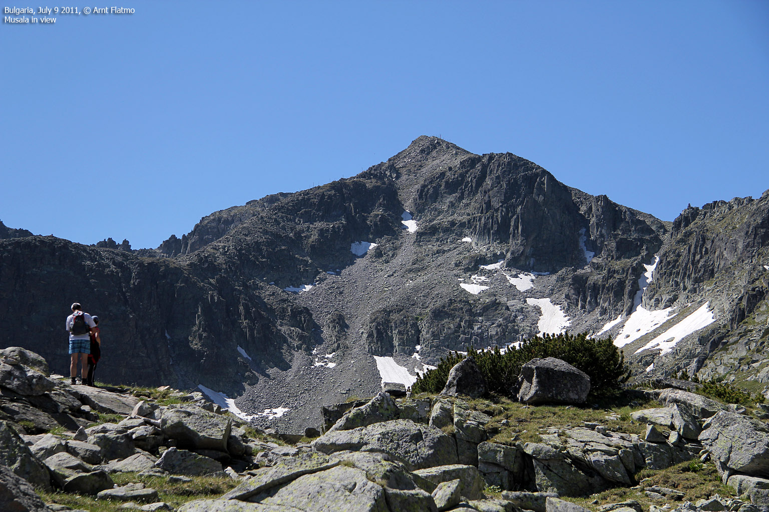
Musala Peak

(Click for larger image)
Introduction
Musala is the highest peak in Bulgaria and the entire Balkan peninsula. The mountain is located in the Rila mountain range and inside the Rila National Park. There are several buildings on top, including a weather station.
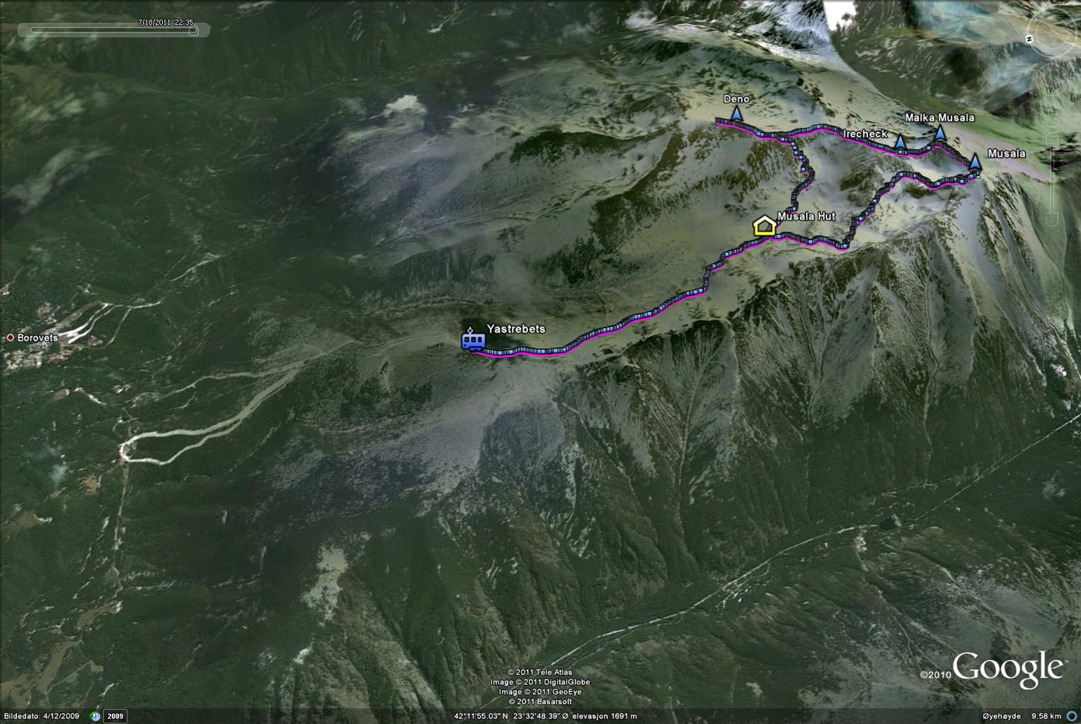
The peak is widely popular, and many choose to take the gondola lift from Borovets (Бороветс) (approx. 1300m) to Yastrebets (2369m) - when it is in operation. On your way up the mountain, you pass the Musala hut (approx. 2400m) and the Everest shelter (approx. 2720m). A well-worn trail runs all the way to the summit, and there are no difficult or airy sections.
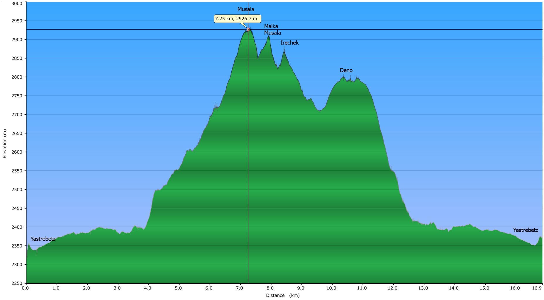
From the summit, you can do a round trip hike across Malka Musala, Irechek and Deno and descend to the Musala hut. The ridge between Musala and Malka Musala is called the Trionites, and is rugged and a bit airy in places.
Deno, Irechek and Malka Musala

(Click for larger image)
Primary factor:
Musala (2925m, N42.17933 E23.58523) has a primary factor of 2473m according to prominence lists on the internet.
The GPS map contours does not seem to be trustworthy, when compared to the GPS readings. Based on the GPS track log, I have set the following (rounded) primary factors for the other peaks; Malka Musala: 60m, Irechek: 40m and Deno: 90m.
Google map
Google's interactive map. You can zoom, pan and click on the markers.
|
|
|
Trail descriptions
| This disclaimer is regarding all of the literature and instructional guides posted on the westcoastpeaks.com website. These instructions are guidelines only, and should not be used in lieu of common sense or judgement when attempting any of the actions involved or instructed. Westcoastpeaks nor myself will not be liable nor will it indemnify any form of compensation to anyone who has injured, harmed or even killed themselves or others while following any of the instructions written within the website. It should be noted by any persons willing to undertake any of the instructions provided that mountains offer varying levels of risk, regardless of size or incline. Risks to be considered are as follows but not limited to: wild animals, weather, the terrain, bad judgement, inappropriate or insufficient equipment, improper training or experience and of course, bad luck... |
The route descriptions are valid per
July
2011.
|
Route 1: Borovets - Musala + round trip across Malka Musala, Irechek and Deno (summer/autumn)
|
|
Access
(all distances are approx. distances)
The starting point for this route description is the village Borovets (Бороветс). Use Google Maps to get the road description from Sofia Airport, Sofia, Bulgaria (if this is your starting point) to Borovets, Samokov, Bulgaria. In short, route 82 is your road to the south. This route is 68,3km and takes 1h:17m (according to Google). You pass the larger town Samokov (Самоков) approx. 8km north of Borovets.
Locate the gondola lift (N42.26647 E23.60361) in the village centre. The gondola (if it is running) will take you from approx. 1320m to 2369m (Yastrebets) - a total distance of 4827 meters. If your head for heights if of the moderate sort, then there may be sections of this gondola trip that you might not like. The rest can sit back and enjoy the views...
If the gondola is not running (Monday through Wednesday might not be good days to rely on it), your hike will be significantly longer; 1046 additional vertical meters and 8km (at least) to the Musala hut - opposed to the 3,6km from Yastrebets to the Musala hut. This page does not describe the route up through the forest.
Make sure you learn when the last gondola for the day leaves Yastrebets...
The route - To Musala
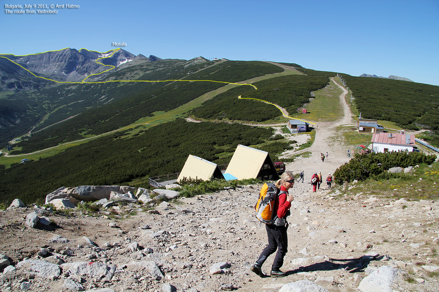
From Yastrebets (N42.22691 E23.58086), follow the 3,6km road to the Musala hut (N42.19812 E23.58751, approx. 2400m). See the above picture. Enjoy the local flora along the way. The Musala hut area consists of a few buildings, including a cabin where you can buy drinks. And a large building that looks like a hotel under construction?. You will also find drinking water here.
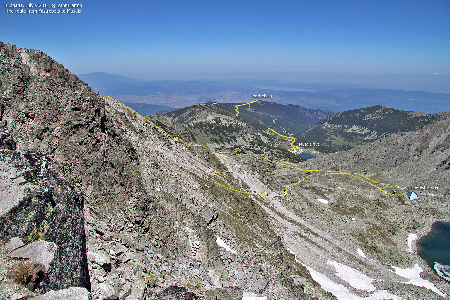
Next follows a 2,5km hike up to the Everest shelter (N42.18352 E23.58838, approx. 2720m - said to be the highest mountain shelter in Bulgaria). The main trail from the Musala hut runs on the west side of the lake just south of the hut.
The final leg up to the top is a 0,9km walk up Musala's northeast ridge. The trail up the ridge is well-worn. Musala summit consists of a few buildings and the official marker is found at (N42.17933 E23.58523).
The route - the round trip
From Musala, follow a much less pronounced path in the direction of Malka Musala. Part of the ridge walk over to the smaller Musala peak is rugged, airy and requires some scrambling, but there are no sections where you have to climb. The terrain is amazing! You will find a couple of large cairns on top of Malka Musala (2902m, N42.18014 E23.59143).
Descend Malka Musala's north ridge, in the direction of Irechek. The terrain is now much easier and you reach the top of Irechek (2852m, N42.18394 E23.59181) with much less effort than you spent on your way to Malka Musala.
From Irechek, head northeast in the direction of Studenia Chal (2720m). Visit this top too, or continue north towards Deno. The hike up Deno's south ridge is easy and the summit (2790m, N42.19664 E23.60317) is marked by a proper cairn. There is a point 0,2km to the northeast of Deno, but it is not higher.
Descend in the direction of the distinct rock in the pass between Deno and Studenia Chal and locate the path down to the Musala hut. It's easy to find (N42.19207 E23.59889) and quite important that you do so!. The path switchbacks down to the basin and the lakes and there are no difficult sections.

The round trip, seen from Musala

(Click for larger image)
Pictures and Trip reports:
- Musala, Malka Musala, Irechek and Deno, July 9 2011
 westcoastpeaks.com
 Other European mountains
 Other Norwegian mountains


