
|


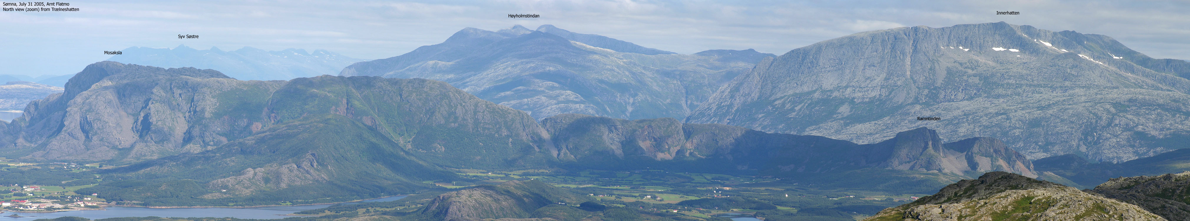
Mosfjellet (also known as Mofjellet) and Ramntinden are two tops found on a rugged, standalone massif, located just north of Brønnøysund. There are two ridges (north and southeast) with the same name - Mosaksla. From the south-eastern Mosaksla, the massif continues southeast across Kjerringskardet and all the way to Ramntinden.
The entire massif has steep cliffs to the west and the south. There are no roads on the east side, so the public route to Mosfjellet runs up the northern Mosaksla, and the public route to Ramntinden runs up via its north-eastern ridge. Both routes are described on this web page.
Mosaksla and Ramntinden are frequently on the list of Fjelltrimmen tops in Brønnøy and Sømna kommuner.
Ramntinden and Mosfjellet/Mosaksla are separated by the Kjerringskardet pass. In case you are considering traversing the massif - this pass, by the looks of it, seem to require climbing. Parts of Mosaksla is a nature preserve. Southeast of Kjerringskardet, you will also find some interesting caves.

Mosaksla (Norge 1:50,000: 526m, Økonomisk Kartverk: 526,01m, UTM 33 W 374681 7271350) has a primary factor of 448m, towards the higher parent Sæterfjellet (599m). The saddle (approx. UTM 33 W 378256 7267693) is found between Ramntinden and point 109m. Ref. Økonomisk Kartverk (5m contours), the saddle is within the range 75-80m, interpolated to 78m.
Ramntinden (Norge 1:50,000: 323m, Økonomisk Kartverk: 322,77m, UTM 33 W 377581 7267485) has a primary factor of 105m, towards the higher parent Mosaksla (526m). The saddle (approx. UTM 33 W 377593 7268135) is found along the ridge, between Ramntinden and Kjerringskardet. Ref. Økonomisk Kartverk (5m contours), the saddle is within the range 215-220m, interpolated to 218m.
Google's interactive map. You can zoom, pan and click on the markers.
Notes: Class ratings are in reference to YDS. Click here for more information.
The trails described below are not necessarily the *easiest* trails to this mountain.
|
RV17 - Mosaksla (summer/autumn)
|
|
Access
(All distances are approx.)
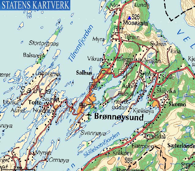
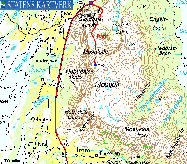
Locate the RV17/RV76 junction, 2,8Km outside the centre of Brønnøysund. Exit towards Horn/Andalsvågen/Vega, and follow RV17 7Km. By the 7Km marker on the right-hand side of the road, you will find the trailhead and parking.
The route


Follow the path, marked in red, into the lower forest. You find ropes in the lower forest, because the turfs are detaching from the mountain. You enter a basin, and the route continue partly steep up to your left. You may need to use your hands for support here and there. Once you are on the mountain ridge, follow it all the way to the summit cairn. You may or may not find a visitor register in a box, in the cairn.
"Extra bonus"...
.. for the experienced hikers. Beginners should not attempt this route:

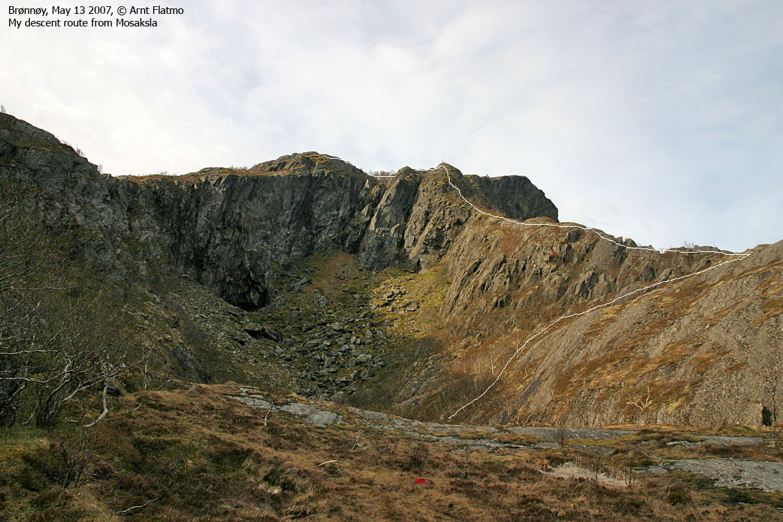
Descend the ridge west of the basin. The name of this ridge is Ytterrabben. You will need to cross a few minor ridges in order to get to the correct ridge. Descend carefully as it gets steeper. Once you slide yourself down a short crack/gully (YDS class 2+), the "problems" are over. Down in the basin, leave the ridge and join your ascent route.
|
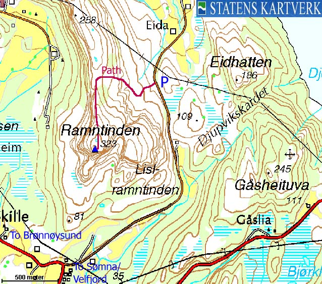
Eide - Ramntinden (summer/autumn)
|
|
Access
(All distances are approx.)
Locate the RV17/RV76 junction, 2,8Km outside the centre of Brønnøysund. Exit towards Horn/Andalsvågen/Vega, and follow RV17 3,8Km. Turn left towards Eide and follow the main road (gravel) 2,1Km. Find parking on your left-hand side.
The route
Follow the road 100m northbound, then turn left and follow a path (marked by red paint) all the way to the top. Note that the cairn (with a container, and possibly a visitor register) is NOT located at the highest point. The highest point is marked by a trigonometric marker - a pole.
In the hillside, the path runs northwest (away) until you reach the ridge and turn south.
You could also visit Lislramntinden on your way down, for additional views. A path takes you down to the pass and then you just head up the flank. Lislramntinden is not marked by a cairn.
 westcoastpeaks.com
Other Nordland mountains
Other Norwegian mountains
westcoastpeaks.com
Other Nordland mountains
Other Norwegian mountains


