
|

Melshovden seen from the road(No Javascript) |
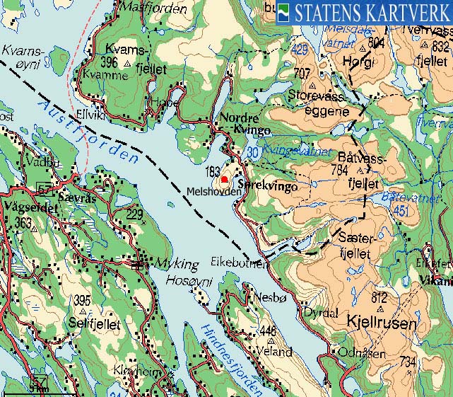
Melshovden is a characteristic and popular coastal hill on Austfjorden. With its 183 meters above sea level, it does not appear on my list of independent mountains exceeding 300m, but if you happen to drive along the road towards Masfjordnes, I recommend you stop and walk up the path to the summit cairn. You get a good view of the area from Sørkvingo and Nordkvingo, as well as some of the high Masfjorden mountains.
Melshovden (M711: 183m, Ø.K: 183,25m) has a primary factor of 140m towards the higher Båtevassfjellet. The saddle is found on the road to Masfjordnes, at Sørkvingo. Ref. Økonomisk Kartverk map (5m contours), you cross the 45m contours on the high route, but not 40m. The saddle has been interpolated to 43m.
Notes: Class ratings are in reference to YDS. Click here for more information.
The trails described below are not necessarily the *easiest* trails to this mountain.
|
Sørkvingo - Melshovden (summer/autumn)
|
|
From Bergen, follow highway E39 northbound towards Førde. Cross Nordhordlandsbrua bridge and pay toll on the north side of the bridge (NOK 45,- per March 2005). Continue 26,2Km on E39 and exit left onto the road towards Masfjordnes just before Eikefettunnelen.
Follow the road towards Masfjordnes for 10,8Km. You will see a turn-out on the right hand side of the road, in a gentle left curve 300m after you pass a bus-stop on both sides of the road. Park here.
Go through an opening in the fence and follow a nature trail all the way to the top. Between the rock and slabs, you will see a visible path. In any case, the direction is quite obvious. The summit is marked by a large cairn, and you may find a trail register at the summit cairn.
|
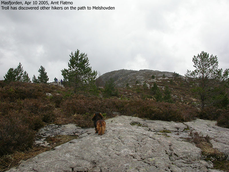
Trip notes Apr 10 2005I decided to visit this hill on my way down from Kvamsfjellet. My two motives were to give the dog some additional exercise before we headed back to Bergen, and to get some pictures of the Masfjorden mountains. We left the car 14:55PM and headed up the path. We caught up with a group of 4 other hikers, and "Troll" decided that this was his new family. I wanted the group to have some privacy, and kept on going. When the other group took a pause, Troll suddenly remembered who is feeding him, and came running in full speed up the hill. I honored him for his loyalty, and together we arrived the summit cairn 15:17PM. An old man named Monrad was sitting on the top of Melshovden when we arrived. When the other group arrived, I learned that this was a man who knew the Masfjorden mountains quite well. We had fun together, identifying all the Masfjorden tops we could see. I also learned from the other group, that hiking maps are being developed both for Masfjorden and Modalen. Fjon ungdoms- og idrettslag has marked routes to a number of Masfjorden mountains, which the general public is encouraged to visit. Collecting mountain tops from a list of local tops is a modern, and now typical, Norwegian outdoor activity. I overheard that on one day during Easter, 58 people had visited this top! After the nice chat with Monrad and the other group, it was time to head back to Bergen. A "lazy" day in Masfjorden was over, but new territory had been visited, which is always interesting.
|
Move cursor to read notes, and click on the images to see full version.
Some of the thumbnails may have been cropped to fit the format.


No Javascript:
Other hordaland mountains
 Other Masfjorden K. mountains
westcoastpeaks.com
Other Masfjorden K. mountains
westcoastpeaks.com

