
|


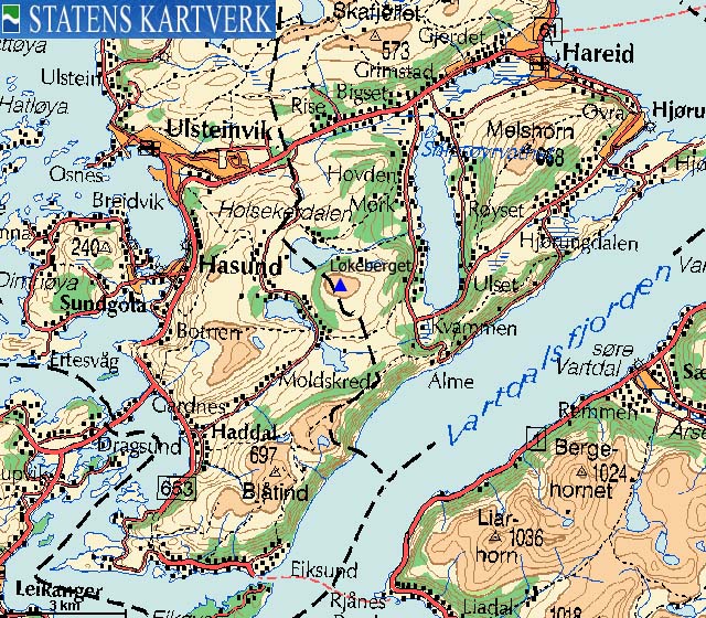
Løkeberget (Onion mountain???) is a standalone mountain that is difficult to see from RV61 between Hareid and Ulsteinvik. From many other angles also, "tucked away" as it is, between Melshornet, Kongsvollen, Hovdenakken/Ramnefjellet and Gardnestua/Hasundhornet. The Ulstein/Hareid kommune border runs only 100m west of the summit, which is located within Hareid kommune.
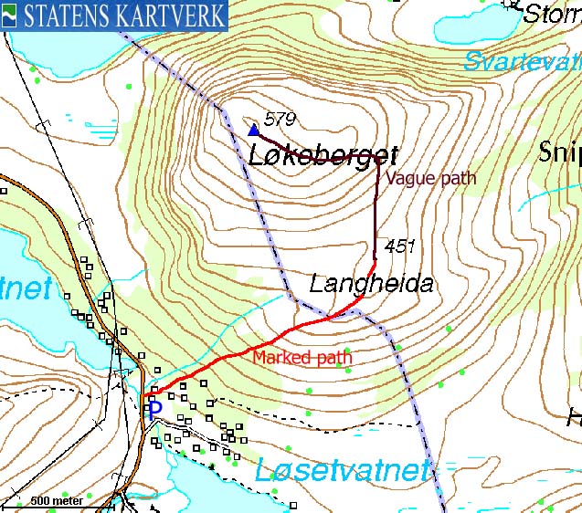
A well marked path takes you from the trailhead by Løsetvatnet and up to Langheida (451m) - a viewpoint on the east side of the mountain. You can follow a vague path up to the summit plateau, where you pass the hump Steinholten (570m) on your way to the summit. The summit is marked by a proper cairn.
Løsetvatnet is also trailhead for Kongsvollen, Blåtind and Gardnestua. There is however a shorter route to Blåtind from further down in Ringstaddalen.
Løkeberget (M711: 579m, Ø.K.: 579,14m, UTM 32 V 341236 6913210) has a primary factor of 300m towards the higher Gardnestua (653m). The saddle is found between lakes Fjellsvatnet and Hammarstøylsvatnet. Ref. Økonomisk Kartverk (5m contours), the saddle is given as a fixed point - 279m.
Note; My GPS recorded 576m as average height over 10 minutes, measured on the ground.
Notes: Class ratings are in reference to YDS. Click here for more information.
The trails described below are not necessarily the *easiest* trails to this mountain.
|
Løsetvatnet - Løkeberget (summer/autumn)
|
|


Access
From Ålesund, follow highway E39 towards Bergen, and then RV61 towards Hareid. Take the Sulesund - Hareid ferry and follow RV61 (roughly) 3Km towards Ulsteinvik. At the roundabout junction outside Ulsteinvik, turn left and follow RV61 southbound. RV61 later turns right (SW) towards Måløy. At this junction, drive straight ahead and keep driving for approx. 1,3Km and turn left towards "Haddal".
Drive approx. 500m on the main road (which curves sharp to the right in the beginning) and turn left into "Ringstaddalen". Follow this road approx. 3,9m (the road turns to gravel road after 2,9Km) to a parking area. You will see the "Blåtind" trailsign on the left-hand side of the road. The parking slots are for the most part reserved, but you will find available pockets here and there.
Alternative route from Hareid;
Follow RV61 6,5Km and turn left onto a gravel road just before the top of the hill. Follow this road (it is a bypass road, so turn left again after 500m) 6,3Km to the Løsetvatnet trailhead described above. This road is not plowed in winter, and opens when the snow has melted away.
The route
Locate the the "Blåtind" trailsign (on the west side of the road), follow the road 130m northbound and turn right when you see the "Løkeberget" trailsign. The route follows the road to cabins for a short while, then forks left into the forest. The path is very well marked with red ribbons and red paint. Follow the path in the northeast direction to Langheida (451m).
From Langheida, a vague path runs northbound up to 510m elevation before it turns westbound and eventually leading towards the high point. Descend your ascent route, or make an off-trail shortcut down the mountain.


Yet another fine evening on Hareidlandet island. After work (Ulsteinvik), I decided to pay Løkeberget a visit this afternoon. The trailhead was the same as for Kongsvollen and Gardnestua, so I knew exactly where the trailhead was. My dog "Troll" and I left the trailhead 16:00PM.
Troll was for certain not in walking mood, and had to be carried in the backpack. The forst path was, overwhelmingly, well marked. A mix of old and new red ribbons and red paint. Troll finally agreed to walk once we were out of the forest. The path led us up to Langheia, where we stumbled across a grouse that was keeping her eggs warm. I hope she returned after we passed. How clever is it to build the nest along the path?
The marked path ended at Langheia, but there was still a visible trail to the top of Løkeberget, which we arrived 16:45PM. It was indeed a fine day, with "deep" afternoon colors. Løkeberget was a very different mountain than its higher, and a bit more rugged neighbours. Løkeberget was more in the category "large hill", and made me think of Scotland. Nothing wrong said about Scottish hills. I've been to the nine highest.
Avoiding to scare the grouse again, I decided to take a shortcut down the mountain. We followed the south ridge, (if Løkeberget can claim to have a ridge) directly into the birch forest, in the direction of the trailhead. The upper part of the forest was dense, yet easy to travel. In the lower part, I had to carry the dog. 17:30PM, I stumbled out of the forest, 200m away from the car.
 westcoastpeaks.com
Other Møre & Romsdal mountains
Other Norwegian mountains
westcoastpeaks.com
Other Møre & Romsdal mountains
Other Norwegian mountains

